National Register of Historic Places listings in Deuel County, South Dakota

Location of Deuel County in South Dakota
This is a list of the National Register of Historic Places listings in Deuel County, South Dakota.
This is intended to be a complete list of the properties and districts on the National Register of Historic Places in Deuel County, South Dakota, United States. The locations of National Register properties and districts for which the latitude and longitude coordinates are included below, may be seen in a Google map.[1]
There are 10 properties and districts listed on the National Register in the county.
- This National Park Service list is complete through NPS recent listings posted May 1, 2015.[2]
Current listings
| [3] |
Name on the Register[4] |
Image |
Date listed[5] |
Location |
City or town |
Description |
|---|
| 1 |
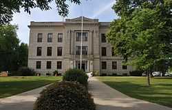
Deuel County Courthouse and Jail |
|
01976-06-16-0000June 16, 1976
(#76001730) |
Highway 22
44°45′17″N 96°41′25″W / 44.754722°N 96.690278°W / 44.754722; -96.690278 (Deuel County Courthouse and Jail) |
Clear Lake |
|
| 2 |
East Highland Lutheran Church |
Upload image |
02000-02-18-0000February 18, 2000
(#00000120) |
Approximately 6 miles northeast of Brandt
44°40′29″N 96°31′31″W / 44.674722°N 96.525278°W / 44.674722; -96.525278 (East Highland Lutheran Church) |
Brandt |
|
| 3 |
First National Bank Building |
Upload image |
01977-12-02-0000December 2, 1977
(#77001242) |
Off Highway 22
44°47′34″N 96°27′24″W / 44.792778°N 96.456667°W / 44.792778; -96.456667 (First National Bank Building) |
Gary |
|
| 4 |
Herrick Barn |
Upload image |
02005-06-22-0000June 22, 2005
(#05000628) |
0.5 miles northwest of the junction of County Road 310 and Highway 101
44°47′43″N 96°28′01″W / 44.795278°N 96.466944°W / 44.795278; -96.466944 (Herrick Barn) |
Gary |
|
| 5 |
Hoffman Barn |
Upload image |
02005-10-26-0000October 26, 2005
(#05001188) |
16937 482 Ave.
44°55′47″N 96°33′31″W / 44.929722°N 96.558611°W / 44.929722; -96.558611 (Hoffman Barn) |
Revillo |
|
| 6 |
Kliegle Garage |
Upload image |
01999-09-29-0000September 29, 1999
(#99001213) |
Lots 1 and 2 of the original townsite of Goodwin
44°52′41″N 96°51′02″W / 44.878056°N 96.850556°W / 44.878056; -96.850556 (Kliegle Garage) |
Goodwin |
|
| 7 |
Odd Fellows Building |
Upload image |
01976-06-03-0000June 3, 1976
(#76001731) |
Main St.
44°47′34″N 96°27′24″W / 44.792778°N 96.456667°W / 44.792778; -96.456667 (Odd Fellows Building) |
Gary |
|
| 8 |
Old Cochrane Road Bridge |
Upload image |
01993-12-09-0000December 9, 1993
(#93001268) |
Abandoned local road over the inlet to Lake Cochrane
44°42′03″N 96°29′15″W / 44.700833°N 96.4875°W / 44.700833; -96.4875 (Old Cochrane Road Bridge) |
Brandt |
|
| 9 |
South Dakota Dept. of Transportation Bridge No. 20-153-210 |
Upload image |
01993-12-09-0000December 9, 1993
(#93001286) |
Local road over Cobb Creek
44°40′27″N 96°34′28″W / 44.674167°N 96.574444°W / 44.674167; -96.574444 (South Dakota Dept. of Transportation Bridge No. 20-153-210) |
Brandt |
|
| 10 |
South Dakota School for the Blind |
Upload image |
01988-05-26-0000May 26, 1988
(#88000570) |
Coteau and 3rd Sts.
44°47′46″N 96°27′18″W / 44.796111°N 96.455°W / 44.796111; -96.455 (South Dakota School for the Blind) |
Gary |
|
See also
References
- ↑ The latitude and longitude information provided in this table was derived originally from the National Register Information System, which has been found to be fairly accurate for about 99% of listings. For about 1% of NRIS original coordinates, experience has shown that one or both coordinates are typos or otherwise extremely far off; some corrections may have been made. A more subtle problem causes many locations to be off by up to 150 yards, depending on location in the country: most NRIS coordinates were derived from tracing out latitude and longitudes off of USGS topographical quadrant maps created under the North American Datum of 1927, which differs from the current, highly accurate WGS84 GPS system used by most on-line maps. Chicago is about right, but NRIS longitudes in Washington are higher by about 4.5 seconds, and are lower by about 2.0 seconds in Maine. Latitudes differ by about 1.0 second in Florida. Some locations in this table may have been corrected to current GPS standards.
- ↑ "National Register of Historic Places: Weekly List Actions". National Park Service, United States Department of the Interior. Retrieved on May 1, 2015.
- ↑ Numbers represent an ordering by significant words. Various colorings, defined here, differentiate National Historic Landmarks and historic districts from other NRHP buildings, structures, sites or objects.
- ↑ "National Register Information System". National Register of Historic Places. National Park Service. 2008-04-24.
- ↑ The eight-digit number below each date is the number assigned to each location in the National Register Information System database, which can be viewed by clicking the number.
|
|---|
| | Topics | |
|---|
| | Lists by states | |
|---|
| | Lists by insular areas | |
|---|
| | Lists by associated states | |
|---|
| | Other areas | |
|---|
|
-
 Category Category
-
 Portal Portal
-
 WikiProject WikiProject
|
|