National Register of Historic Places listings in Dallas County, Alabama
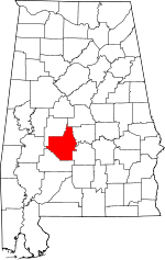
Location of Dallas County in Alabama
This is a list of the National Register of Historic Places listings in Dallas County, Alabama.
This is intended to be a complete list of the properties and districts on the National Register of Historic Places in Dallas County, Alabama, United States. Latitude and longitude coordinates are provided for many National Register properties and districts; these locations may be seen together in a Google map.[1]
There are 31 properties and districts listed on the National Register in the county, including 2 National Historic Landmarks.
- This National Park Service list is complete through NPS recent listings posted May 1, 2015.[2]
Current listings
| [3] | Name on the Register | Image | Date listed[4] | Location | City or town | Description |
|---|---|---|---|---|---|---|
| 1 | Adams Grove Presbyterian Church | 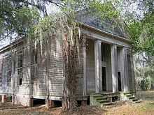 |
(#86001239) |
Southern side of Cahaba-Greenville Rd. 32°16′20″N 87°01′51″W / 32.272222°N 87.030833°W |
Sardis | Wooden-framed Presbyterian church, built in the Greek Revival style in 1853. |
| 2 | Antique Store |  |
(#86003662) |
Off State Route 22 32°39′32″N 86°55′24″W / 32.659023°N 86.923292°W |
Plantersville | |
| 3 | Brown Chapel African Methodist Episcopal Church | 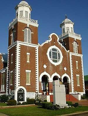 |
(#82002009) |
410 Martin Luther King, Jr. St. 32°24′45″N 87°00′58″W / 32.4125°N 87.016111°W |
Selma | Brick African Methodist Episcopal church, built in 1908. Known for its association with the Civil Rights Movement and Selma to Montgomery marches. |
| 4 | Cahaba |  |
(#73000341) |
11 miles (18 km) southwest of Selma at the junction of the Cahaba and Alabama Rivers 32°19′07″N 87°05′57″W / 32.318546°N 87.099266°W |
Cahaba | First permanent state capital of Alabama (1820–1825); today a ghost town. |
| 5 | Carlowville Historic District | 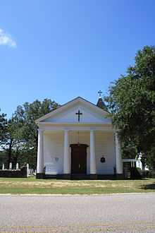 |
(#78000487) |
17 miles (27 km) south of Selma on State Route 89 32°05′15″N 87°02′01″W / 32.087392°N 87.033691°W |
Carlowville | |
| 6 | Christian Church and Parsonage |  |
(#86003664) |
Off State Route 22 32°39′24″N 86°55′29″W / 32.656667°N 86.924722°W |
Plantersville | |
| 7 | Dallas County Courthouse | 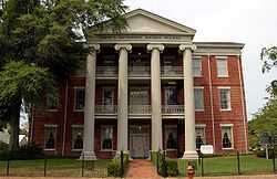 |
(#75000310) |
109 Union St. 32°24′18″N 87°01′33″W / 32.405°N 87.025833°W |
Selma | Three-story brick building in the Greek Revival style, built as the Central Masonic Institute in 1847. It later served as the county courthouse and as a hospital. |
| 8 | Doctor's Office | Upload image | (#86003663) |
Junction of 1st Ave. north of Oak St. and 1st Ave. 32°41′03″N 86°55′24″W / 32.684167°N 86.923333°W |
Plantersville | |
| 9 | Driskell-Martin House | 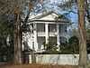 |
(#86003661) |
Northwestern corner of the junction of Cherry St. and 1st Ave. 32°39′36″N 86°55′26″W / 32.66°N 86.923889°W |
Plantersville | |
| 10 | First Baptist Church | 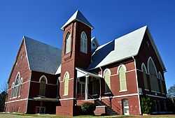 |
(#79000383) |
709 Martin Luther King, Jr. St. 32°24′51″N 87°01′04″W / 32.414167°N 87.017778°W |
Selma | Historically African American Baptist church, built in the Gothic Revival style in 1894. Known for its association with the Civil Rights Movement. |
| 11 | J. Bruce Hain House | Upload image | (#01001295) |
5826 State Route 41 32°17′17″N 86°59′14″W / 32.288056°N 86.987222°W |
Sardis | |
| 12 | Icehouse Historic District | 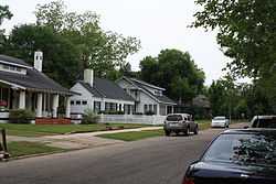 |
(#90000886) |
Roughly bounded by Jefferson Davis and Dallas Aves., Union and Lapsley Sts., and Valley Creek 32°24′39″N 87°01′54″W / 32.410889°N 87.031653°W |
Selma | |
| 13 | Sullivan and Richie Jean Jackson House | Upload image | (#13001033) |
1416 Lapsley Ave. 32°25′09″N 87°01′52″W / 32.419070°N 87.031244°W |
Selma | |
| 14 | Marshall's Grove | Upload image | (#82002010) |
State Route 22 32°27′58″N 87°00′23″W / 32.466111°N 87.006389°W |
Selma | |
| 15 | John Tyler Morgan House | 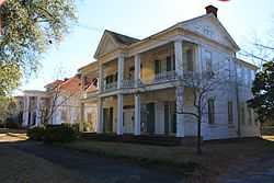 |
(#72000159) |
719 Tremont St. 32°24′49″N 87°01′39″W / 32.413611°N 87.0275°W |
Selma | |
| 16 | Old Town Historic District | 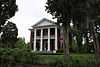 |
(#78000486) |
Roughly bounded by the Alabama River, Jefferson Davis Ave., Pettus, Broad, and Franklin Sts.; also Jefferson Davis Ave.; an area roughly bounded by Broad, Dallas, U.S. Route 80, and Franklin; Selma Ave.; and Franklin St. 32°24′37″N 87°01′31″W / 32.410201°N 87.025323°W |
Selma | Boundaries after the "also" represent a boundary increase of December 15, 2003 |
| 17 | Edmund Pettus Bridge | 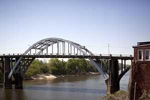 |
(#13000281) |
U.S. Route 80 across the Alabama River 32°24′20″N 87°01′07″W / 32.4056°N 87.0186°W |
Selma | |
| 18 | Wesley Plattenburg House | 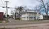 |
(#92001827) |
601 Washington St. 32°24′50″N 87°01′20″W / 32.413889°N 87.022222°W |
Selma | |
| 19 | Pleasant Hill Presbyterian Church | 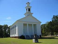 |
(#99000465) |
0.2 miles (0.32 km) east of the junction of County Roads 7 and 12 32°09′53″N 86°54′30″W / 32.164722°N 86.908333°W |
Pleasant Hill | Wooden-framed Presbyterian church, built in the Greek Revival style in 1851. |
| 20 | Riverdale |  |
(#79000384) |
Northeast of Selma on River Rd. 32°26′02″N 86°52′11″W / 32.433889°N 86.869722°W |
Selma | |
| 21 | Riverview Historic District | 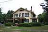 |
(#90000887) |
Roughly bounded by Selma Ave., Satterfield and Lapsley Sts., and the Alabama River 32°24′11″N 87°01′50″W / 32.403063°N 87.030666°W |
Selma | |
| 22 | St. Luke's Episcopal Church | 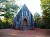 |
(#82002008) |
Beech St. (Cahaba Rd.) near intersection with Capitol Ave. 32°19′09″N 87°06′19″W / 32.319167°N 87.105278°W |
Cahaba | Wooden-framed Episcopal church, built in the Carpenter Gothic style in 1854. |
| 23 | St. Paul's Episcopal Church |  |
(#75000311) |
210 Lauderdale St. 32°24′31″N 87°01′18″W / 32.408611°N 87.021667°W |
Selma | Brick Episcopal church, built in the Gothic Revival style in 1875. |
| 24 | Marcus Meyer Skinner House | 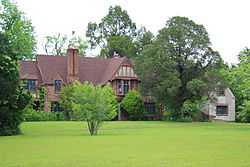 |
(#87001418) |
2612 Summerfield Rd. 32°26′15″N 87°02′01″W / 32.437431°N 87.033540°W |
Selma | |
| 25 | Street Manual Training School | Upload image | (#99000891) |
263 County Road 38 32°06′49″N 87°03′34″W / 32.113657°N 87.059557°W |
Richmond and Minter | |
| 26 | Sturdivant Hall | 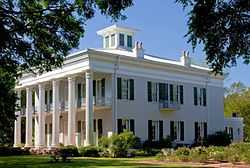 |
(#73000340) |
713 Mabry St. 32°24′47″N 87°01′44″W / 32.413056°N 87.028889°W |
Selma | Greek Revival style mansion designed by Thomas Helm Lee and completed in 1856. |
| 27 | Summerfield District | 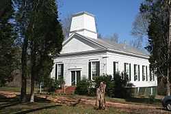 |
(#82002011) |
Selma-Summerfield and Marion Rds., Centenary and College Sts. 32°31′03″N 87°02′45″W / 32.517434°N 87.045751°W |
Summerfield | |
| 28 | Tabernacle Baptist Church | Upload image | (#13000469) |
1431 Broad St. 32°25′10″N 87°01′28″W / 32.419575°N 87.024486°W |
Selma | Part of the Civil Rights Movement in Selma, Alabama MPS |
| 29 | Todd House | 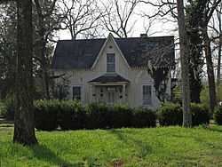 |
(#86003665) |
Southern side of Oak St. west of 1st Ave. 32°39′21″N 86°55′52″W / 32.655833°N 86.931111°W |
Plantersville | |
| 30 | U.S. Post Office Building | 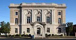 |
(#76000322) |
908 Alabama Ave. 32°24′27″N 87°01′15″W / 32.4075°N 87.020833°W |
Selma | Beaux-Arts style Federal Government building designed by James Knox Taylor and completed in 1909. |
| 31 | Valley Creek Presbyterian Church | 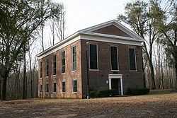 |
(#76000323) |
North of Selma on Valley Creek Rd. 32°28′14″N 87°01′28″W / 32.470556°N 87.024444°W |
Valley Grande | Brick Presbyterian church, built in the Greek Revival style in 1857. |
| 32 | Water Avenue Historic District |  |
(#72000160) |
Water Ave.; also Water Ave. bounded by Lauderdale, MLK Boulevard, Beech Creek, and the Alabama River 32°24′27″N 87°01′00″W / 32.40752°N 87.016783°W |
Selma | Second set of boundaries represents a boundary increase of July 7, 2005 |
See also
| Wikimedia Commons has media related to National Register of Historic Places in Dallas County, Alabama. |
- List of National Historic Landmarks in Alabama
- National Register of Historic Places listings in Alabama
References
- ↑ The latitude and longitude information provided in this table was derived originally from the National Register Information System, which has been found to be fairly accurate for about 99% of listings. For about 1% of NRIS original coordinates, experience has shown that one or both coordinates are typos or otherwise extremely far off; some corrections may have been made. A more subtle problem causes many locations to be off by up to 150 yards, depending on location in the country: most NRIS coordinates were derived from tracing out latitude and longitudes off of USGS topographical quadrant maps created under the North American Datum of 1927, which differs from the current, highly accurate WGS84 GPS system used by most on-line maps. Chicago is about right, but NRIS longitudes in Washington are higher by about 4.5 seconds, and are lower by about 2.0 seconds in Maine. Latitudes differ by about 1.0 second in Florida. Some locations in this table may have been corrected to current GPS standards.
- ↑ "National Register of Historic Places: Weekly List Actions". National Park Service, United States Department of the Interior. Retrieved on May 1, 2015.
- ↑ Numbers represent an ordering by significant words. Various colorings, defined here, differentiate National Historic Landmarks and historic districts from other NRHP buildings, structures, sites or objects.
- ↑ The eight-digit number below each date is the number assigned to each location in the National Register Information System database, which can be viewed by clicking the number.
| |||||||||||||||||||||


| |||||||||||||||||||||||||||||