National Register of Historic Places listings in Curry County, Oregon

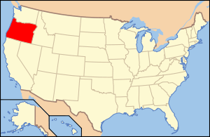
Location of Curry County in Oregon
This list presents the full set of buildings, structures, objects, sites, or districts designated on the National Register of Historic Places in Curry County, Oregon, and offers brief descriptive information about each of them. The National Register recognizes places of national, state, or local historic significance across the United States.[1] Out of over 90,000 National Register sites nationwide,[2] Oregon is home to over 1,950,[3] and 45 of those are found in Curry County.
- This National Park Service list is complete through NPS recent listings posted May 1, 2015.[4]
Current listings
| [5] | Name on the Register | Image | Date listed[6] | Location | City or town | Description |
|---|---|---|---|---|---|---|
| 1 | 35-CU-215-High Point Shell Midden | Upload image | (#01000135) |
Address restricted[7] |
Carpenterville | |
| 2 | Arch Rock | 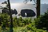 |
(#97001058) |
Address restricted[7] |
Carpenterville | |
| 3 | Archeological Site 35CU1 | Upload image | (#97001043) |
Address restricted[7] |
Sixes | |
| 4 | Archeological Site 35CU13 | Upload image | (#97001045) |
Address restricted[7] |
Port Orford | |
| 5 | Archeological Site 35CU14 | Upload image | (#97001046) |
Address restricted[7] |
Port Orford | |
| 6 | Archeological Site 35CU142 | Upload image | (#97001050) |
Address restricted[7] |
Port Orford | |
| 7 | Archeological Site 35CU153 | Upload image | (#97001049) |
Address restricted[7] |
Port Orford | |
| 8 | Archeological Site 35CU16 | Upload image | (#97001048) |
Address restricted[7] |
Port Orford | |
| 9 | Archeological Site 35CU31 | Upload image | (#97001055) |
Address restricted[7] |
Pistol River | |
| 10 | Archeological Site 35CU69 | Upload image | (#97001066) |
Address restricted[7] |
Carpenterville | |
| 11 | Archeological Site 35CU79 | Upload image | (#97001070) |
Address restricted[7] |
Brookings | |
| 12 | Archeological Site 35CU80 | Upload image | (#97001069) |
Address restricted[7] |
Brookings | |
| 13 | Archeological Site 35CU83 | Upload image | (#97001042) |
Address restricted[7] |
Sixes | |
| 14 | Blacklock Point Lithic Site | Upload image | (#94000805) |
Address restricted[7] |
Port Orford | |
| 15 | Blacklock Point Shell Midden | Upload image | (#94000804) |
Address restricted[7] |
Port Orford | |
| 16 | Cape Blanco Lighthouse | 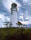 |
(#73002339) |
Westernmost part of Cape Blanco, W of Sixes 42°50′14″N 124°33′44″W / 42.837222°N 124.562222°W |
Sixes | |
| 17 | Cape Blanco Lithic Site | Upload image | (#92000667) |
Address restricted[7] |
Port Orford | |
| 18 | Central Building | 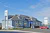 |
(#80003309) |
703 Chetco Ave. 42°03′06″N 124°16′55″W / 42.051667°N 124.281944°W |
Brookings | Built in 1915 by the C&O Lumber Company, the Central Building served as administration building for the Brookings Land & Townsite Co. in the mill town of Brookings. |
| 19 | Eagle Rock | Upload image | (#97001054) |
Address restricted[7] |
Pistol River | |
| 20 | Gold Beach Ranger Station |  |
(#86000818) |
29279 Ellensburg Avenue 42°24′07″N 124°25′08″W / 42.401944°N 124.418889°W |
Gold Beach | The Cascadian Rustic buildings of the Gold Beach Ranger Station were built in 1936 by a Civilian Conservation Corps crew from Gasquet, California. |
| 21 | Harris Park Mound | Upload image | (#97001068) |
Address restricted[7] |
Brookings | |
| 22 | Patrick Hughes House | 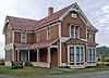 |
(#80003310) |
Cape Blanco State Park 42°50′33″N 124°32′13″W / 42.8425°N 124.536944°W |
Sixes | The Hughes House, which combines elements of the Queen Anne and Stick-Eastlake architectural styles, was designed by P.J. Lindberg and built in 1898. |
| 23 | Mary D. Hume | 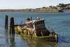 |
(#79002052) |
Port of Gold Beach 42°25′18″N 124°25′06″W / 42.421667°N 124.418333°W |
Gold Beach | Steamer built in 1880 in Gold Beach, wrecked at Gold Beach |
| 24 | Indian Sands | Upload image | (#97001061) |
Address restricted[7] |
Carpenterville | |
| 25 | Indian Sands | Upload image | (#92000668) |
Address restricted[7] |
Brookings | |
| 26 | Khustenete-Hustenate-Xusteneten | Upload image | (#97001057) |
Address restricted[7] |
Carpenterville | |
| 27 | Peter John Lindberg House | 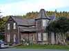 |
(#14001131) |
906 N. Washington Street 42°44′46″N 124°29′44″W / 42.746038°N 124.495638°W |
Port Orford | |
| 28 | Little Ridge-Cape Sebastian (35CU77) | Upload image | (#97001051) |
Address restricted[7] |
Pistol River | |
| 29 | Little Ridge-Cape Sebastian (35CU78) | Upload image | (#97001052) |
Address restricted[7] |
Pistol River | |
| 30 | Lone Ranch Creek Mound | Upload image | (#97001067) |
Address restricted[7] |
Brookings | |
| 31 | Miller Creek | Upload image | (#97001059) |
Address restricted[7] |
Carpenterville | Also known as the Miller Shell Midden. |
| 32 | Newburgh Lithic Site (35CU209) | Upload image | (#97001041) |
Address restricted[7] |
Sixes | |
| 33 | Pistol River Site-Chetlessentan-Chetleshin-Chet-less-chun-dunn |  |
(#97001053) |
Atop bluffs immediately north of the mouth of the Pistol River[8]:322 42°16′52″N 124°24′05″W / 42.281111°N 124.401389°W |
Pistol River | |
| 34 | Port Orford Coast Guard Station | _(curDB4272).jpg) |
(#98000606) |
92331 Coast Guard Hill Rd. 42°44′23″N 124°30′33″W / 42.739722°N 124.509167°W |
Port Orford | |
| 35 | Port Orford Site | Upload image | (#97001044) |
Address restricted[7] |
Port Orford | |
| 36 | Rogue River Bridge No. 01172 | |
(#05000814) |
OR Coast 9, US 101, MP 327.70 42°25′39″N 124°24′44″W / 42.4275°N 124.412222°W |
Gold Beach | Also known as the Isaac Lee Patterson Bridge. |
| 37 | Rogue River Ranch |  |
(#75001581) |
E of Agness near confluence of Mule Creek and Rogue River 42°43′06″N 123°52′53″W / 42.718333°N 123.881389°W |
Agness | |
| 38 | Sheep Trail Shell Midden (35CU32) | Upload image | (#97001056) |
Address restricted[7] |
Carpenterville | |
| 39 | Sixes Hotel | 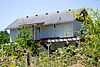 |
(#92001325) |
93316 Sixes River Rd. 42°49′03″N 124°28′45″W / 42.8175°N 124.479167°W |
Sixes | |
| 40 | Thunder Rock | Upload image | (#97001060) |
Address restricted[7] |
Carpenterville | |
| 41 | Whale Head | 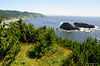 |
(#97001062) |
Address restricted[7] |
Carpenterville | |
| 42 | Whaleshead Lithic Site (35CU207) | Upload image | (#97001064) |
Address restricted[7] |
Carpenterville | |
| 43 | Whaleshead South Midden (35CU208) | Upload image | (#97001063) |
Address restricted[7] |
Carpenterville | |
| 44 | Whaleshead Trail Viewpoint (35CU36) |  |
(#97001065) |
Address restricted[7] |
Carpenterville | |
| 45 | Wheeler Ridge Japanese Bombing Site | .jpg) |
(#06000589) |
Rogue River-Siskiyou National Forest 42°04′42″N 124°06′40″W / 42.078333°N 124.111111°W |
Brookings | Site of first bombing in the United States by airplane |
Former listings
| [5] | Name on the Register | Image | Date listed | Date removed | Location | City or town | Summary |
|---|---|---|---|---|---|---|---|
| 1 | Archeological Site 35CU156 | Upload image | (#97001047) | Address restricted[7] |
Port Orford |
See also
- National Register of Historic Places listings in Oregon
- Listings in neighboring counties: Coos, Del Norte, Douglas, Josephine
- Historic preservation
- History of Oregon
- Lists of Oregon-related topics
References
- ↑ Andrus, Patrick W.; Shrimpton, Rebecca H. et al. (2002), How to Apply the National Register Criteria for Evaluation, National Register Bulletin (15), National Park Service, U.S. Department of the Interior, retrieved June 20, 2014 .
- ↑ National Park Service, National Register of Historic Places Program: Research, retrieved January 28, 2015.
- ↑ Oregon Parks and Recreation Department, Oregon Historic Sites Database, retrieved July 26, 2014. Note that a simple count of National Register records in this database returns a slightly higher total than actual listings, due to duplicate records. A close reading of detailed query results is necessary to arrive at the precise count.
- ↑ "National Register of Historic Places: Weekly List Actions". National Park Service, United States Department of the Interior. Retrieved on May 1, 2015.
- ↑ 5.0 5.1 Numbers represent an ordering by significant words. Various colorings, defined here, differentiate National Historic Landmarks and historic districts from other NRHP buildings, structures, sites or objects.
- ↑ The eight-digit number below each date is the number assigned to each location in the National Register Information System database, which can be viewed by clicking the number.
- ↑ 7.0 7.1 7.2 7.3 7.4 7.5 7.6 7.7 7.8 7.9 7.10 7.11 7.12 7.13 7.14 7.15 7.16 7.17 7.18 7.19 7.20 7.21 7.22 7.23 7.24 7.25 7.26 7.27 7.28 7.29 7.30 7.31 7.32 7.33 Federal and state laws and practices restrict general public access to information regarding the specific location of sensitive archeological sites in many instances. The main reasons for such restrictions include the potential for looting, vandalism, or trampling. See: Knoerl, John; Miller, Diane; Shrimpton, Rebecca H. (1990), Guidelines for Restricting Information about Historic and Prehistoric Resources, National Register Bulletin (29), National Park Service, U.S. Department of the Interior, OCLC 20706997.
- ↑ Moss, Madonna L., and George B. Wasson, Jr. "Intimate Relations with the past: The Story of an Athapaskan Village on the Southern Northwest Coast of North America". World Archaeology 29.3 (1998): 317-332.
External links
- Oregon Parks and Recreation Department, National Register Program
- National Park Service, National Register of Historic Places site
 Media related to National Register of Historic Places in Curry County, Oregon at Wikimedia Commons

| ||||||||||||||||||||||||||
| |||||||||||||||||||||