National Register of Historic Places listings in Crook County, Wyoming
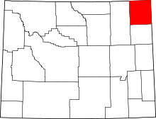
Location of Crook County in Wyoming
This is a list of the National Register of Historic Places listings in Crook County, Wyoming.
This is intended to be a complete list of the properties and districts on the National Register of Historic Places in Crook County, Wyoming, United States. The locations of National Register properties and districts for which the latitude and longitude coordinates are included below, may be seen in a Google map.[1]
There are 13 properties and districts listed on the National Register in the county.
- This National Park Service list is complete through NPS recent listings posted May 1, 2015.[2]
Current listings
| [3] |
Name on the Register |
Image |
Date listed[4] |
Location |
City or town |
Description |
|---|
| 1 |
Arch Creek Petroglyphs (48CK41) |
Upload image |
01986-12-04-0000December 4, 1986
(#86003458) |
Address Restricted
|
Moorcroft |
|
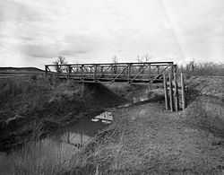
| 2 |
DXN Bridge over Missouri River |
|
01985-02-22-0000February 22, 1985
(#85000419) |
Crook County Road 18-200
44°58′59″N 104°29′39″W / 44.983056°N 104.494167°W / 44.983056; -104.494167 (DXN Bridge over Missouri River) |
Hulett |
|
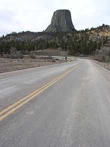
| 3 |
Entrance Road-Devils Tower National Monument |
|
02000-07-24-0000July 24, 2000
(#00000854) |
Devils Tower National Monument
44°35′14″N 104°42′52″W / 44.587222°N 104.714444°W / 44.587222; -104.714444 (Entrance Road-Devils Tower National Monument) |
Devils Tower |
|
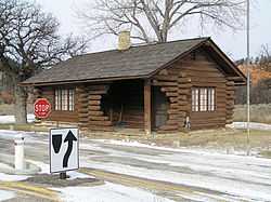
| 4 |
Entrance Station-Devils Tower National Monument |
|
02000-07-24-0000July 24, 2000
(#00000853) |
Devils Tower National Monument
44°35′23″N 104°42′00″W / 44.589722°N 104.7°W / 44.589722; -104.7 (Entrance Station-Devils Tower National Monument) |
Devils Tower |
|
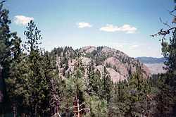
| 5 |
Inyan Kara Mountain |
|
01973-04-24-0000April 24, 1973
(#73001929) |
About 15 mi (24 km) south of Sundance in Black Hills National Forest
44°12′45″N 104°20′40″W / 44.2125°N 104.344444°W / 44.2125; -104.344444 (Inyan Kara Mountain) |
Sundance |
|
| 6 |
McKean Archeological Site (48CK7) |
Upload image |
01991-04-01-0000April 1, 1991
(#91000326) |
Within the Keyhole Reservoir[5]
44°21′55″N 104°50′20″W / 44.365278°N 104.838889°W / 44.365278; -104.838889 (McKean Archeological Site (48CK7)) |
Moorcroft |
|
| 7 |
Old Headquarters Area Historic District |
|
02000-07-20-0000July 20, 2000
(#00000852) |
Devils Tower National Monument
44°35′26″N 104°43′13″W / 44.590556°N 104.720278°W / 44.590556; -104.720278 (Old Headquarters Area Historic District) |
Devils Tower |
|
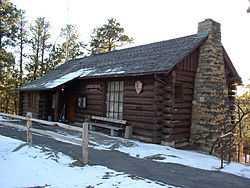
| 8 |
Ranch A |
Upload image |
01997-03-17-0000March 17, 1997
(#97000227) |
Off Riflepit Rd., approximately 3 mi (4.8 km) east of Interstate 90/U.S. Route 14, Ranch A National Fish Genetics Laboratory
44°29′27″N 104°06′53″W / 44.490833°N 104.114722°W / 44.490833; -104.114722 (Ranch A) |
Beulah |
|
| 9 |
Sundance School |
Upload image |
01985-12-02-0000December 2, 1985
(#85003099) |
108 N. 4th St.
44°24′22″N 104°22′38″W / 44.406111°N 104.377222°W / 44.406111; -104.377222 (Sundance School) |
Sundance |
|
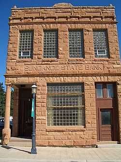
| 10 |
Sundance State Bank |
|
01984-03-23-0000March 23, 1984
(#84003660) |
301 Main St.
44°24′22″N 104°22′47″W / 44.406111°N 104.379722°W / 44.406111; -104.379722 (Sundance State Bank) |
Sundance |
|
| 11 |
Tower Ladder-Devils Tower National Monument |
|
02000-07-24-0000July 24, 2000
(#00000855) |
Devils Tower National Monument
44°35′23″N 104°42′50″W / 44.589722°N 104.713889°W / 44.589722; -104.713889 (Tower Ladder-Devils Tower National Monument) |
Devils Tower |
|
| 12 |
Vore Buffalo Jump |
|
01973-04-11-0000April 11, 1973
(#73001930) |
Between Interstate 90 and the old U.S. Route 14, 5 miles west of the South Dakota border[6]
44°32′09″N 104°09′24″W / 44.535833°N 104.156667°W / 44.535833; -104.156667 (Vore Buffalo Jump) |
Sundance |
|
| 13 |
Wyoming Mercantile |
Upload image |
01991-04-16-0000April 16, 1991
(#91000435) |
Wyoming Highway 24
44°38′25″N 104°11′01″W / 44.640278°N 104.183611°W / 44.640278; -104.183611 (Wyoming Mercantile) |
Aladdin |
|
See also
References
- ↑ The latitude and longitude information provided in this table was derived originally from the National Register Information System, which has been found to be fairly accurate for about 99% of listings. For about 1% of NRIS original coordinates, experience has shown that one or both coordinates are typos or otherwise extremely far off; some corrections may have been made. A more subtle problem causes many locations to be off by up to 150 yards, depending on location in the country: most NRIS coordinates were derived from tracing out latitude and longitudes off of USGS topographical quadrant maps created under the North American Datum of 1927, which differs from the current, highly accurate WGS84 GPS system used by most on-line maps. Chicago is about right, but NRIS longitudes in Washington are higher by about 4.5 seconds, and are lower by about 2.0 seconds in Maine. Latitudes differ by about 1.0 second in Florida. Some locations in this table may have been corrected to current GPS standards.
- ↑ "National Register of Historic Places: Weekly List Actions". National Park Service, United States Department of the Interior. Retrieved on May 1, 2015.
- ↑ Numbers represent an ordering by significant words. Various colorings, defined here, differentiate National Historic Landmarks and historic districts from other NRHP buildings, structures, sites or objects.
- ↑ The eight-digit number below each date is the number assigned to each location in the National Register Information System database, which can be viewed by clicking the number.
- ↑ Mulloy, William. "The McKean Site in Northeastern Wyoming". Southwestern Journal of Anthropology 10.4 (1954): 432-460: 435.
- ↑ Location derived from this Wyoming State Historic Preservation Office website; the NRIS lists the site as "Address Restricted"
|
|---|
| | Topics | |
|---|
| | Lists by states | |
|---|
| | Lists by insular areas | |
|---|
| | Lists by associated states | |
|---|
| | Other areas | |
|---|
|
-
 Category Category
-
 Portal Portal
-
 WikiProject WikiProject
|
|