National Register of Historic Places listings in Crawford County, Missouri

Location of Crawford County in Missouri
This is a list of the National Register of Historic Places listings in Crawford County, Missouri.
This is intended to be a complete list of the properties and districts on the National Register of Historic Places in Crawford County, Missouri, United States. Latitude and longitude coordinates are provided for many National Register properties and districts; these locations may be seen together in a Google map.[1]
There are 13 properties and districts listed on the National Register in the county.
- This National Park Service list is complete through NPS recent listings posted May 1, 2015.[2]
Current listings
| [3] | Name on the Register | Image | Date listed[4] | Location | City or town | Description |
|---|---|---|---|---|---|---|
| 1 | Big Bend Rural School | Upload image | (#78001643) |
Route 19 37°59′47″N 91°22′31″W / 37.996389°N 91.375278°W |
Steelville | |
| 2 | Cuba City Jail | Upload image | (#14000880) |
Prairie St. & 300 blk. of S. Main St. 38°03′40″N 91°24′16″W / 38.0612°N 91.4044°W |
Cuba | Part of the Cuba, Missouri Multiple Property Submission (MPS) |
| 3 | Cuba High School Annex | Upload image | (#13000223) |
308 N. Smith St. 38°03′49″N 91°24′31″W / 38.063579°N 91.408514°W |
Cuba | Part of the Cuba, Missouri Multiple Property Submission (MPS) |
| 4 | Cuba Lodge No. 312 A.F. and A.M. | Upload image | (#14000881) |
201 N. Smith St. 38°03′46″N 91°24′26″W / 38.0627°N 91.4073°W |
Cuba | Part of the Cuba, Missouri Multiple Property Submission (MPS) |
| 5 | Dillard Mill Historic District | 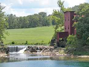 |
(#14001157) |
142 Dillard Mill Rd. 37°43′03″N 91°12′24″W / 37.7175°N 91.2067°W |
Davisville vicinity | |
| 6 | George B. Hamilton House | Upload image | (#14000882) |
401 E. Washington St. 38°03′48″N 91°24′04″W / 38.0634°N 91.4010°W |
Cuba | |
| 7 | Maj. Gen. William S. Harney Summer Home | Upload image | (#84002144) |
332 S. Mansion Ave. 38°12′13″N 91°09′48″W / 38.203611°N 91.163333°W |
Sullivan | |
| 8 | Hotel Cuba | Upload image | (#14000883) |
600 E. Main St. 38°03′47″N 91°23′55″W / 38.0631°N 91.3987°W |
Cuba | |
| 9 | John Manson Munro House | Upload image | (#14000884) |
305 W. Washington Ave. 38°03′44″N 91°24′20″W / 38.0623°N 91.4055°W |
Cuba | |
| 10 | Scotia Iron Furnace Stack | Upload image | (#69000099) |
6.3 miles (10.1 km) south east of Leasburg on County Road H 38°02′15″N 91°11′47″W / 38.0375°N 91.196389°W |
Leasburg | |
| 11 | Snelson-Brinker House | Upload image | (#07000576) |
Route 8 37°56′56″N 91°30′04″W / 37.948889°N 91.501111°W |
Steelville | |
| 12 | Uptown Cuba Historic District | Upload image | (#13000072) |
Roughly W. Main Ave., N. and S. Smith and S. Hickory Sts., and W. Washington Boulevard 38°03′40″N 91°24′24″W / 38.061051°N 91.406726°W |
Cuba | |
| 13 | Wagon Wheel Motel, Café and Station | Upload image | (#03000183) |
901-905 E. Washington St. 38°03′52″N 91°23′43″W / 38.06448°N 91.39516°W |
Cuba |
See also
- List of National Historic Landmarks in Missouri
- National Register of Historic Places listings in Missouri
References
| Wikimedia Commons has media related to National Register of Historic Places in Crawford County, Missouri. |
- ↑ The latitude and longitude information provided in this table was derived originally from the National Register Information System, which has been found to be fairly accurate for about 99% of listings. For about 1% of NRIS original coordinates, experience has shown that one or both coordinates are typos or otherwise extremely far off; some corrections may have been made. A more subtle problem causes many locations to be off by up to 150 yards, depending on location in the country: most NRIS coordinates were derived from tracing out latitude and longitudes off of USGS topographical quadrant maps created under the North American Datum of 1927, which differs from the current, highly accurate WGS84 GPS system used by most on-line maps. Chicago is about right, but NRIS longitudes in Washington are higher by about 4.5 seconds, and are lower by about 2.0 seconds in Maine. Latitudes differ by about 1.0 second in Florida. Some locations in this table may have been corrected to current GPS standards.
- ↑ "National Register of Historic Places: Weekly List Actions". National Park Service, United States Department of the Interior. Retrieved on May 1, 2015.
- ↑ Numbers represent an ordering by significant words. Various colorings, defined here, differentiate National Historic Landmarks and historic districts from other NRHP buildings, structures, sites or objects.
- ↑ The eight-digit number below each date is the number assigned to each location in the National Register Information System database, which can be viewed by clicking the number.
| ||||||||||||||||||||||||||
| |||||||||||||||||||||||||||||