| [3] |
Name on the Register[4] |
Image |
Date listed[5] |
Location |
City or town |
Description |
|---|
| 1 |
Ailes House |
Upload image |
01991-04-09-0000April 9, 1991
(#91000420) |
Rhymes Rd. near its junction with Mississippi Highway 27
32°01′30″N 90°22′15″W / 32.025°N 90.370833°W / 32.025; -90.370833 (Ailes House) |
Crystal Springs |
|
| 2 |
Alford-Little House |
Upload image |
01982-10-19-0000October 19, 1982
(#82000573) |
South of Georgetown off Mississippi Highway 27
31°47′35″N 90°08′45″W / 31.793056°N 90.145833°W / 31.793056; -90.145833 (Alford-Little House) |
Georgetown |
|
| 3 |
Bayou Pierre Bridge |
Upload image |
02005-06-10-0000June 10, 2005
(#05000565) |
Mississippi Highway 18
32°00′10″N 90°41′23″W / 32.002778°N 90.689722°W / 32.002778; -90.689722 (Bayou Pierre Bridge) |
Carpenter |
|
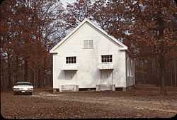
| 4 |
Carpenter United Methodist Church |
Upload image |
01996-06-28-0000June 28, 1996
(#96000705) |
Carpenter Rd., 1.1 miles north of its junction with Mississippi Highway 18
32°02′08″N 90°40′53″W / 32.035556°N 90.681389°W / 32.035556; -90.681389 (Carpenter United Methodist Church) |
Utica |
|
| 5 |
Cherry Grove |
Upload image |
01990-08-10-0000August 10, 1990
(#90001224) |
Old U.S. Route 51, north of its junction with Mississippi Highway 27
32°02′32″N 90°19′20″W / 32.042222°N 90.322222°W / 32.042222; -90.322222 (Cherry Grove) |
Crystal Springs |
|
| 6 |
Cook House |
|
01983-12-08-0000December 8, 1983
(#83003941) |
222 Extension St.
31°51′32″N 90°23′48″W / 31.858889°N 90.396667°W / 31.858889; -90.396667 (Cook House) |
Hazlehurst |
|
| 7 |
George Washington Copley House |
Upload image |
01996-03-01-0000March 1, 1996
(#96000181) |
210 Copley St.
31°59′07″N 90°21′43″W / 31.985278°N 90.361944°W / 31.985278; -90.361944 (George Washington Copley House) |
Crystal Springs |
|
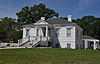
| 8 |
Robert L. Covington House |
|
01984-03-01-0000March 1, 1984
(#84002139) |
240 S. Extension St.
31°51′23″N 90°23′50″W / 31.856389°N 90.397222°W / 31.856389; -90.397222 (Robert L. Covington House) |
Hazlehurst |
Designed by architect George Franklin Barber
|
| 9 |
Crystal Springs Historic District |
Upload image |
01997-03-14-0000March 14, 1997
(#97000236) |
Roughly bounded by Independence, Pearl, Newton, and Marion Sts.
31°59′14″N 90°21′28″W / 31.987222°N 90.357778°W / 31.987222; -90.357778 (Crystal Springs Historic District) |
Crystal Springs |
|
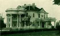
| 10 |
Isaac Newton Ellis House |
Upload image |
01987-11-02-0000November 2, 1987
(#87001914) |
258 S. Extension St.
31°51′19″N 90°23′49″W / 31.855278°N 90.396944°W / 31.855278; -90.396944 (Isaac Newton Ellis House) |
Hazlehurst |
Designed by architect George Franklin Barber
|
| 11 |
Gallman Historic District |
Upload image |
01986-03-31-0000March 31, 1986
(#86000832) |
Roughly U.S. Route 51 and Church St.
31°55′53″N 90°23′27″W / 31.931389°N 90.390833°W / 31.931389; -90.390833 (Gallman Historic District) |
Gallman |
|
| 12 |
Gatesville Bridge |
Upload image |
01988-11-16-0000November 16, 1988
(#88002482) |
Spans the Pearl River on a county road east of Gatesville
31°59′46″N 90°13′26″W / 31.996111°N 90.223889°W / 31.996111; -90.223889 (Gatesville Bridge) |
Gatesville |
Extends into Simpson County
|
| 13 |
Hargrave House |
Upload image |
01993-04-05-0000April 5, 1993
(#91001465) |
Mississippi Highway 28, 14 miles west of Hazlehurst
31°45′04″N 90°34′55″W / 31.751111°N 90.581944°W / 31.751111; -90.581944 (Hargrave House) |
Hazlehurst |
|
| 14 |
Hazlehurst Historic District |
|
01998-11-05-0000November 5, 1998
(#98001336) |
Roughly bounded by S. Extension, Georgetown, Gallatin, and Monticello Sts.
31°51′40″N 90°23′41″W / 31.861111°N 90.394722°W / 31.861111; -90.394722 (Hazlehurst Historic District) |
Hazlehurst |
|
| 15 |
Homochitto River Bridge |
Upload image |
01988-11-16-0000November 16, 1988
(#88002491) |
Spans the Homochitto River on a county road
31°42′48″N 90°40′01″W / 31.713333°N 90.666944°W / 31.713333; -90.666944 (Homochitto River Bridge) |
Hazlehurst |
|
| 16 |
Charles Morris Huber House |
Upload image |
01994-11-10-0000November 10, 1994
(#94001306) |
199 N. Jackson St.
31°59′29″N 90°21′11″W / 31.991389°N 90.353056°W / 31.991389; -90.353056 (Charles Morris Huber House) |
Crystal Springs |
|
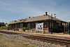
| 17 |
Illinois Central Railroad Passenger Depot |
|
01996-03-01-0000March 1, 1996
(#96000182) |
138 N. Ragsdale Ave.
31°51′39″N 90°23′39″W / 31.860833°N 90.394167°W / 31.860833; -90.394167 (Illinois Central Railroad Passenger Depot) |
Hazlehurst |
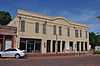
|
| 18 |
Dr. William Little House |
Upload image |
01993-03-04-0000March 4, 1993
(#93000143) |
1022 Collier St.
31°41′52″N 90°23′47″W / 31.697778°N 90.396389°W / 31.697778; -90.396389 (Dr. William Little House) |
Wesson |
|
| 19 |
Marchetti Farm |
Upload image |
01996-03-01-0000March 1, 1996
(#96000183) |
134 Dale Dr.
31°51′09″N 90°24′11″W / 31.8525°N 90.403056°W / 31.8525; -90.403056 (Marchetti Farm) |
Hazlehurst |
|
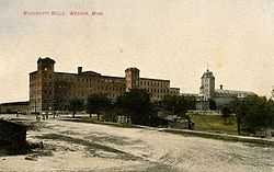
| 20 |
Mississippi Mills Packing and Shipping Rooms |
|
01996-03-01-0000March 1, 1996
(#96000185) |
2058 U.S. Route 51
31°42′05″N 90°23′50″W / 31.701389°N 90.397222°W / 31.701389; -90.397222 (Mississippi Mills Packing and Shipping Rooms) |
Wesson |
|
| 21 |
Mount Hope |
Upload image |
01985-03-21-0000March 21, 1985
(#85000616) |
Off Route 2 across from Mt. Hope Cemetery
31°52′43″N 90°34′38″W / 31.878611°N 90.577222°W / 31.878611; -90.577222 (Mount Hope) |
Hazlehurst |
|
| 22 |
Old Wesson Public School Building |
Upload image |
01980-10-16-0000October 16, 1980
(#80002235) |
Off U.S. Route 51
31°42′08″N 90°23′22″W / 31.702222°N 90.389444°W / 31.702222; -90.389444 (Old Wesson Public School Building) |
Wesson |
|
| 23 |
C.H. Parsons House |
Upload image |
01984-09-07-0000September 7, 1984
(#84002140) |
208 W. Georgetown St.
31°59′18″N 90°21′33″W / 31.988333°N 90.359167°W / 31.988333; -90.359167 (C.H. Parsons House) |
Crystal Springs |
|
| 24 |
Pearl River Bridge on Mississippi Highway 28 |
Upload image |
02005-06-10-0000June 10, 2005
(#05000566) |
Mississippi Highway 28
31°52′31″N 90°08′17″W / 31.875278°N 90.138056°W / 31.875278; -90.138056 (Pearl River Bridge on Mississippi Highway 28) |
Georgetown |
|
| 25 |
Pleasant Valley Methodist Church |
Upload image |
01996-08-01-0000August 1, 1996
(#96000703) |
Pleasant Valley Rd., 0.8 miles east of its junction with Mississippi Highway 28
31°45′38″N 90°33′13″W / 31.760556°N 90.553611°W / 31.760556; -90.553611 (Pleasant Valley Methodist Church) |
Hazlehurst |
|
| 26 |
Dr. Robert W. Rea House |
Upload image |
01996-11-01-0000November 1, 1996
(#96001267) |
1034 Church St.
31°42′01″N 90°23′53″W / 31.700278°N 90.398056°W / 31.700278; -90.398056 (Dr. Robert W. Rea House) |
Wesson |
|
| 27 |
James Samuel Rea House |
Upload image |
01996-03-01-0000March 1, 1996
(#96000184) |
1193 U.S. Route 51
31°41′53″N 90°24′04″W / 31.698056°N 90.401111°W / 31.698056; -90.401111 (James Samuel Rea House) |
Wesson |
|
| 28 |
Tabernacle Methodist Church |
|
01996-06-28-0000June 28, 1996
(#96000704) |
Dentville Rd., 4.6 miles north of its junction with Mississippi Highway 28
31°54′37″N 90°28′17″W / 31.910278°N 90.471389°W / 31.910278; -90.471389 (Tabernacle Methodist Church) |
Hazlehurst |
|
| 29 |
US Post Office-Crystal Springs |
Upload image |
01993-03-18-0000March 18, 1993
(#80004887) |
224 E. Marion St.
31°59′09″N 90°21′25″W / 31.985833°N 90.356944°W / 31.985833; -90.356944 (US Post Office-Crystal Springs) |
Crystal Springs |
|
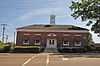
| 30 |
US Post Office-Hazlehurst |
|
01993-03-18-0000March 18, 1993
(#80004886) |
130 Caldwell Dr.
31°51′41″N 90°23′44″W / 31.861389°N 90.395556°W / 31.861389; -90.395556 (US Post Office-Hazlehurst) |
Hazlehurst |
|
| 31 |
Jenkins H. Welch House |
Upload image |
01988-06-30-0000June 30, 1988
(#88000972) |
½ mile north of Mississippi Highway 28 on Dentville Rd.
31°52′50″N 90°24′57″W / 31.880556°N 90.415833°W / 31.880556; -90.415833 (Jenkins H. Welch House) |
Hazlehurst |
|
| 32 |
Wesson Presbyterian Church |
Upload image |
02015-01-14-0000January 14, 2015
(#14001151) |
1022 E. Railroad Ave.
31°41′56″N 90°23′50″W / 31.6989°N 90.3973°W / 31.6989; -90.3973 (Wesson Presbyterian Church) |
Wesson |
|
| 33 |
Col. William James Willing House |
Upload image |
01992-07-10-0000July 10, 1992
(#92000835) |
272 S. Jackson St.
31°58′59″N 90°21′28″W / 31.983056°N 90.357778°W / 31.983056; -90.357778 (Col. William James Willing House) |
Crystal Springs |
|