National Register of Historic Places listings in Coos County, Oregon

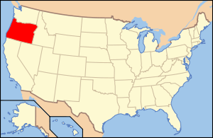
Location of Coos County in Oregon
This list presents the full set of buildings, structures, objects, sites, or districts designated on the National Register of Historic Places in Coos County, Oregon, and offers brief descriptive information about each of them. The National Register recognizes places of national, state, or local historic significance across the United States.[1] Out of over 90,000 National Register sites nationwide,[2] Oregon is home to over 1,950,[3] and 52 of those are found in Coos County.
- This National Park Service list is complete through NPS recent listings posted May 1, 2015.[4]
Current listings
| [5] | Name on the Register | Image | Date listed[6] | Location | City or town | Description |
|---|---|---|---|---|---|---|
| 1 | 35-CS-130-The Osprey Site | Upload image | (#01000131) |
Address restricted[7] |
North Bend | |
| 2 | Edwin and Ethel Abernethy House | 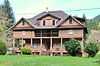 |
(#88001532) |
Box 103, Sitkum Route 43°09′28″N 123°57′42″W / 43.157837°N 123.961730°W |
Myrtle Point vicinity | |
| 3 | Archeological Site 35CS129 | Upload image | (#97001031) |
Address restricted[7] |
Charleston | |
| 4 | Archeological Site 35CS24 | Upload image | (#97001029) |
Address restricted[7] |
North Bend | |
| 5 | Archeological Site 35CS39 | Upload image | (#97001036) |
Address restricted[7] |
Charleston | |
| 6 | Archeological Site 35CS66 | Upload image | (#97001034) |
Address restricted[7] |
Charleston | |
| 7 | Archeological Site 35CS67 | Upload image | (#97001033) |
Address restricted[7] |
Charleston | |
| 8 | Archeological Site 35CS8 | Upload image | (#97001040) |
Address restricted[7] |
Bandon | |
| 9 | Archeological Site 35CS9 | Upload image | (#97001039) |
Address restricted[7] |
Bandon | |
| 10 | A. H. Black and Company Building | 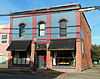 |
(#90001586) |
531 Spruce St. 43°03′54″N 124°08′28″W / 43.065125°N 124.141042°W |
Myrtle Point | |
| 11 | Breuer Building | 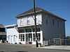 |
(#92001308) |
460 1st Street SW 43°07′15″N 124°25′06″W / 43.120748°N 124.418334°W |
Bandon | |
| 12 | Bullards Beach Site | Upload image | (#97001037) |
Address restricted[7] |
Bandon | |
| 13 | Cape Arago Lighthouse | 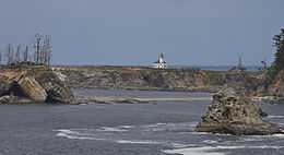 |
(#73002338) |
Gregory Point, north of Cape Arago and about 2 miles (3.2 km) southwest of Coos Bay entrance 43°20′28″N 124°22′31″W / 43.341248°N 124.375330°W |
Charleston | |
| 14 | Cape Arago Site (35CS10) | 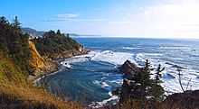 |
(#97001035) |
Address restricted[7] |
Charleston | |
| 15 | Leo J. Cary House | 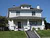 |
(#92001317) |
572 E. 1st St. 43°10′30″N 124°10′59″W / 43.175076°N 124.182981°W |
Coquille | |
| 16 | Chandler Hotel and Annex | 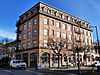 |
(#84002966) |
187 Central Ave. 43°22′04″N 124°12′50″W / 43.367760°N 124.213852°W |
Coos Bay | |
| 17 | J. S. Coke Building | 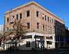 |
(#91000048) |
150 Central Ave. 43°22′05″N 124°12′50″W / 43.368126°N 124.213828°W |
Coos Bay | |
| 18 | Coos Bay Bridge No. 01823 | |
(#05000817) |
OR Coast 9, US101, MP233.99 43°25′44″N 124°13′18″W / 43.428765°N 124.221772°W |
North Bend | |
| 19 | Coos Bay Carnegie Library | 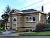 |
(#86000297) |
515 Market Ave. 43°22′09″N 124°13′02″W / 43.369182°N 124.217357°W |
Coos Bay | |
| 20 | Coos Bay National Bank Building |  |
(#89001868) |
201 Central Ave. 43°22′04″N 124°12′52″W / 43.367779°N 124.214443°W |
Coos Bay | |
| 21 | Coquille City Hall | 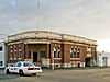 |
(#92001318) |
99 E. 2nd St. 43°10′33″N 124°11′18″W / 43.175719°N 124.188280°W |
Coquille | |
| 22 | Coquille River Life Boat Station | 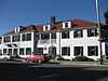 |
(#84002969) |
390 1st Street SW 43°07′14″N 124°25′05″W / 43.120680°N 124.417936°W |
Bandon | |
| 23 | Coquille River Light | 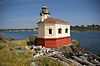 |
(#74001682) |
Bullard's Beach State Park 43°07′26″N 124°25′27″W / 43.123883°N 124.424289°W |
Bandon | |
| 24 | Egyptian Theatre | 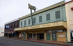 |
(#10000281) |
229 S. Broadway 43°22′00″N 124°12′49″W / 43.366771°N 124.213518°W |
Coos Bay | |
| 25 | John Neal and Dora Gearhart House | Upload image | (#99001003) |
Address restricted[7] |
Myrtle Point | |
| 26 | Judge Lintner Harlocker House | 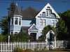 |
(#92001315) |
18 S. Collier St. 43°10′25″N 124°11′08″W / 43.173538°N 124.185547°W |
Coquille | |
| 27 | Hotel North Bend | .jpg) |
(#05000932) |
768 Virginia St. 43°24′24″N 124°13′28″W / 43.406796°N 124.224411°W |
North Bend | |
| 28 | Hub Department Store Building | 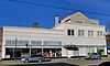 |
(#92001307) |
125 Central Ave. 43°22′04″N 124°12′48″W / 43.367736°N 124.213450°W |
Coos Bay | |
| 29 | Koski Building | .jpg) |
(#93001509) |
241 N. Broadway 43°22′08″N 124°12′48″W / 43.368938°N 124.213414°W |
Coos Bay | |
| 30 | Marshfield City Hall | 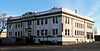 |
(#97000125) |
375 Central Ave. 43°22′04″N 124°12′57″W / 43.367717°N 124.215792°W |
Coos Bay | |
| 31 | Marshfield Elks Temple | 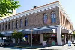 |
(#83002146) |
195 S. 2nd St. 43°22′03″N 124°12′50″W / 43.367446°N 124.213843°W |
Coos Bay | |
| 32 | Marshfield Hotel | .jpg) |
(#84002971) |
275 Broadway 43°22′09″N 124°12′48″W / 43.369147°N 124.213411°W |
Coos Bay | |
| 33 | Marshfield I.O.O.F. Cemetery | 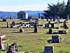 |
(#12000483) |
750 Ingersoll Ave. 43°21′36″N 124°13′12″W / 43.360097°N 124.219895°W |
Coos Bay | |
| 34 | Marshfield Sun Printing Plant | 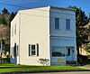 |
(#73001574) |
1049 N. Front St. 43°22′28″N 124°12′44″W / 43.374573°N 124.212220°W |
Coos Bay | |
| 35 | Mussell Reef Village | Upload image | (#97001030) |
Address restricted[7] |
Charleston | |
| 36 | Myrtle Arms Apartment Building | 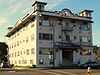 |
(#85003478) |
613 Central Ave. 43°22′04″N 124°13′06″W / 43.367720°N 124.218245°W |
Coos Bay | |
| 37 | Nasburg–Lockhart House | 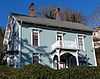 |
(#85003038) |
687 N. 3rd St. 43°22′19″N 124°12′54″W / 43.371943°N 124.215112°W |
Coos Bay | |
| 38 | Hjalte Nerdrum House | 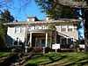 |
(#93000435) |
955 S. 5th St. 43°21′32″N 124°13′05″W / 43.358833°N 124.217947°W |
Coos Bay | |
| 39 | Nerdrum–Conrad House | 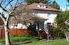 |
(#04000616) |
979 S. 5th St. 43°21′30″N 124°13′05″W / 43.358438°N 124.217932°W |
Coos Bay | |
| 40 | Captain Bror W. Olsson House | 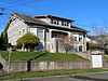 |
(#86002905) |
631 S. 10th St. 43°21′47″N 124°13′20″W / 43.363109°N 124.222356°W |
Coos Bay | |
| 41 | John E. and Christina Paulson House | 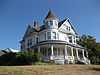 |
(#83002147) |
86 N. Dean St. 43°10′29″N 124°11′04″W / 43.174611°N 124.184411°W |
Coquille | |
| 42 | Philpott Site (35 CS 1) | Upload image | (#79002049) |
Address restricted[7] |
Bandon | |
| 43 | Reorganized Church of Latter Day Saints | _(cooDA0164).jpg) |
(#79002050) |
705 Maple St.[8] 43°03′51″N 124°08′24″W / 43.064281°N 124.139870°W |
Myrtle Point | |
| 44 | Running Foxe Midden (35CS131) | Upload image | (#97001038) |
Address restricted[7] |
Bandon | |
| 45 | St. James Episcopal Church | 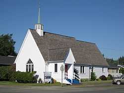 |
(#92001316) |
210 E. 3rd St. 43°10′38″N 124°11′12″W / 43.177204°N 124.186566°W |
Coquille | |
| 46 | Samuels Site (35CS138) | Upload image | (#97001032) |
Address restricted[7] |
Charleston | |
| 47 | Sandy Creek Bridge | .jpg) |
(#79002051) |
Sandy Creek Rd. 43°00′23″N 123°53′30″W / 43.006367°N 123.891769°W |
Remote | |
| 48 | Seelig–Byler House | Upload image | (#93001510) |
1920 N. 14th St. 43°22′54″N 124°13′38″W / 43.381555°N 124.227284°W |
Coos Bay | |
| 49 | A. J. Sherwood House | 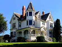 |
(#92001314) |
257 E. Main St. 43°10′25″N 124°11′11″W / 43.173520°N 124.186345°W |
Coquille | |
| 50 | Maj. Morton Tower House | 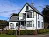 |
(#85003453) |
486 Schetter Ave. 43°23′39″N 124°16′31″W / 43.394251°N 124.275334°W |
Coos Bay | |
| 51 | Tower–Flanagan House | 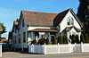 |
(#84002976) |
476 Newmark Ave. 43°23′35″N 124°16′35″W / 43.392988°N 124.276300°W |
Coos Bay | |
| 52 | Tribal Hall of the Confederated Tribes of Coos, Lower Umpqua and Siuslaw Indians | 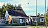 |
(#89000202) |
338 Wallace St. 43°23′19″N 124°15′57″W / 43.388723°N 124.265863°W |
Coos Bay |
Former listing
| [5] | Name on the Register | Image | Date listed | Date removed | Location | City or town | Summary |
|---|---|---|---|---|---|---|---|
| 1 | Powers Hotel | Upload image | (#86001216) | 310 2nd Ave. 42°52′47″N 124°04′11″W / 42.879722°N 124.069722°W |
Powers |
See also
- National Register of Historic Places listings in Oregon
- Listings in neighboring counties: Curry, Douglas
- Historic preservation
- History of Oregon
- Lists of Oregon-related topics
References
- ↑ Andrus, Patrick W.; Shrimpton, Rebecca H. et al. (2002), How to Apply the National Register Criteria for Evaluation, National Register Bulletin (15), National Park Service, U.S. Department of the Interior, retrieved June 20, 2014 .
- ↑ National Park Service, National Register of Historic Places Program: Research, retrieved January 28, 2015.
- ↑ Oregon Parks and Recreation Department, Oregon Historic Sites Database, retrieved July 26, 2014. Note that a simple count of National Register records in this database returns a slightly higher total than actual listings, due to duplicate records. A close reading of detailed query results is necessary to arrive at the precise count.
- ↑ "National Register of Historic Places: Weekly List Actions". National Park Service, United States Department of the Interior. Retrieved on May 1, 2015.
- ↑ 5.0 5.1 Numbers represent an ordering by significant words. Various colorings, defined here, differentiate National Historic Landmarks and historic districts from other NRHP buildings, structures, sites or objects.
- ↑ The eight-digit number below each date is the number assigned to each location in the National Register Information System database, which can be viewed by clicking the number.
- ↑ 7.0 7.1 7.2 7.3 7.4 7.5 7.6 7.7 7.8 7.9 7.10 7.11 7.12 7.13 7.14 Federal and state laws and practices restrict general public access to information regarding the specific location of sensitive archeological sites in many instances. The main reasons for such restrictions include the potential for looting, vandalism, or trampling. See: Knoerl, John; Miller, Diane; Shrimpton, Rebecca H. (1990), Guidelines for Restricting Information about Historic and Prehistoric Resources, National Register Bulletin (29), National Park Service, U.S. Department of the Interior, OCLC 20706997.
- ↑ Coos County Logging Museum, retrieved September 24, 2014
External links
- Oregon Parks and Recreation Department, National Register Program
- National Park Service, National Register of Historic Places site
 Media related to National Register of Historic Places in Coos County, Oregon at Wikimedia Commons

| ||||||||||||||||||||||||||
| |||||||||||||||||||||||||