| [3] |
Name on the Register[4] |
Image |
Date listed[5] |
Location |
City or town |
Description |
|---|
| 1 |
Benjamin Aldrich Homestead |
Upload image |
02003-03-11-0000March 11, 2003
(#03000109) |
East terminus of Aldrich Rd., 0.46 miles east of Piper Hill
44°55′41″N 71°28′35″W / 44.928056°N 71.476389°W / 44.928056; -71.476389 (Benjamin Aldrich Homestead) |
Colebrook |
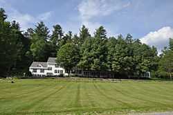
|
| 2 |
The Balsams |
|
02002-03-13-0000March 13, 2002
(#02000166) |
NH 26, 10 mi (16 km) east of Colebrook
44°52′08″N 71°18′25″W / 44.868889°N 71.306944°W / 44.868889; -71.306944 (The Balsams) |
Dixville |
|
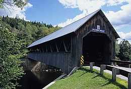
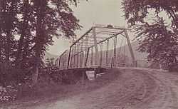
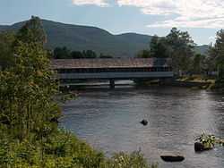
| 3 |
Columbia Covered Bridge |
|
01976-12-12-0000December 12, 1976
(#76000123) |
Across Connecticut River between U.S. Route 3 and VT 102
44°51′12″N 71°33′05″W / 44.853333°N 71.551389°W / 44.853333; -71.551389 (Columbia Covered Bridge) |
Columbia |
Extends into Lemington, Vermont
|
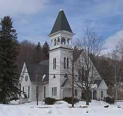
| 4 |
Congregational Church |
|
01980-01-04-0000January 4, 1980
(#80000282) |
921 Main St.
44°28′40″N 71°10′18″W / 44.477778°N 71.171667°W / 44.477778; -71.171667 (Congregational Church) |
Berlin |
|
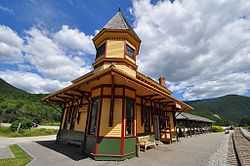
| 5 |
Crawford Depot |
|
01982-04-29-0000April 29, 1982
(#82001672) |
Off U.S. Route 302
44°13′04″N 71°24′40″W / 44.2178°N 71.4111°W / 44.2178; -71.4111 (Crawford Depot) |
Carroll |
Restored former train station, now a visitor center at the top of Crawford Notch
|
| 6 |
Crawford House Artist's Studio |
Upload image |
01985-09-12-0000September 12, 1985
(#85002193) |
AMC Highland Center, Route 302[6]
44°13′11″N 71°24′40″W / 44.2197°N 71.4112°W / 44.2197; -71.4112 (Crawford House Artist's Studio) |
Carroll |
Home and studio of artist Frank Shapleigh, 1877-1893; now part of the Appalachian Mountain Club's Highland Center
|
| 7 |
Garland Mill |
Upload image |
01982-11-12-0000November 12, 1982
(#82000616) |
Garland Rd.
44°28′24″N 71°28′50″W / 44.473333°N 71.480556°W / 44.473333; -71.480556 (Garland Mill) |
Lancaster |
|
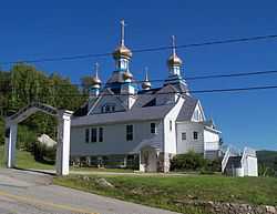
| 8 |
Holy Resurrection Orthodox Church |
|
01979-05-16-0000May 16, 1979
(#79000196) |
Petrograd St.
44°28′06″N 71°11′30″W / 44.468333°N 71.191667°W / 44.468333; -71.191667 (Holy Resurrection Orthodox Church) |
Berlin |
An Orthodox church built by Russian immigrants in 1915
|
| 9 |
Indian Stream Schoolhouse |
Upload image |
02011-10-11-0000October 11, 2011
(#11000730) |
Tabor Rd.
45°02′47″N 71°26′39″W / 45.046389°N 71.444167°W / 45.046389; -71.444167 (Indian Stream Schoolhouse) |
Pittsburg |
|
| 10 |
Martin Homestead |
Upload image |
01998-10-30-0000October 30, 1998
(#98001145) |
U.S. Route 3, 3 mi (4.8 km) north of North Stratford
44°46′16″N 71°35′44″W / 44.771111°N 71.595556°W / 44.771111; -71.595556 (Martin Homestead) |
North Stratford |
|
| 11 |
Meadow Bridge |
|
02003-12-10-0000December 10, 2003
(#03001284) |
Spur of North Rd. in Shelburne across the Androscoggin River
44°24′16″N 71°04′03″W / 44.404444°N 71.0675°W / 44.404444; -71.0675 (Meadow Bridge) |
Shelburne |
Bridge is disassembled beside modern bridge approaches.
|
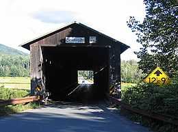
| 12 |
Mount Orne Covered Bridge |
|
01976-12-12-0000December 12, 1976
(#76000124) |
Over Connecticut River southwest of Lancaster off NH 135
44°27′38″N 71°39′12″W / 44.460556°N 71.653333°W / 44.460556; -71.653333 (Mount Orne Covered Bridge) |
Lancaster |
Also listed in the National Park Service NRHP database in Lunenburg, Vermont
|
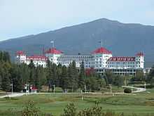
| 13 |
Mount Washington Hotel |
|
01978-09-27-0000September 27, 1978
(#78000213) |
Off U.S. Route 302
44°15′29″N 71°26′25″W / 44.258056°N 71.440278°W / 44.258056; -71.440278 (Mount Washington Hotel) |
Bretton Woods |
Spa hotel in the White Mountains; site of 1944 Bretton Woods international monetary conference.
|
| 14 |
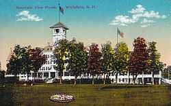
Mountain View House |
|
02004-06-09-0000June 9, 2004
(#04000588) |
120 Mountain View Rd.
44°23′55″N 71°35′19″W / 44.398611°N 71.588611°W / 44.398611; -71.588611 (Mountain View House) |
Whitefield |
|
| 15 |
Mt. Jasper Lithic Source |
Upload image |
01992-05-29-0000May 29, 1992
(#92000631) |
1½ miles northwest of the confluence of the Dead and Androscoggin Rivers
44°29′08″N 71°11′40″W / 44.485556°N 71.194444°W / 44.485556; -71.194444 (Mt. Jasper Lithic Source) |
Berlin |
|
| 16 |
Philbrook Farm Inn |
|
01984-03-15-0000March 15, 1984
(#84002804) |
North Rd.
44°24′16″N 71°03′08″W / 44.404444°N 71.052222°W / 44.404444; -71.052222 (Philbrook Farm Inn) |
Shelburne |
|
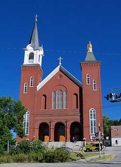
| 17 |
St. Anne Church |
|
01979-05-29-0000May 29, 1979
(#79000197) |
58 Church St.
44°28′22″N 71°10′41″W / 44.472778°N 71.178056°W / 44.472778; -71.178056 (St. Anne Church) |
Berlin |
A Catholic church built in 1900 by French immigrants
|
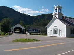
| 18 |
Stark Covered Bridge |
|
01980-12-01-0000December 1, 1980
(#80000283) |
East of Groveton at NH 110 and Northside Rd.
44°36′03″N 71°24′30″W / 44.600833°N 71.408333°W / 44.600833; -71.408333 (Stark Covered Bridge) |
Stark |
Over Upper Ammonoosuc River
|
| 19 |
Stark Union Church |
|
01983-12-08-0000December 8, 1983
(#83004089) |
NH 110
44°36′04″N 71°24′30″W / 44.601111°N 71.408333°W / 44.601111; -71.408333 (Stark Union Church) |
Stark |
|
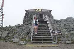
| 20 |
Tip-Top House |
|
01982-01-11-0000January 11, 1982
(#82001673) |
Mount Washington State Park
44°16′14″N 71°18′14″W / 44.270556°N 71.303889°W / 44.270556; -71.303889 (Tip-Top House) |
Sargent's Purchase |
|
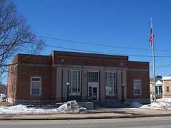
| 21 |
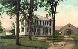
US Post Office-Lancaster Main |
|
01986-07-17-0000July 17, 1986
(#86002245) |
120 Main St.
44°29′15″N 71°34′10″W / 44.4875°N 71.569444°W / 44.4875; -71.569444 (US Post Office-Lancaster Main) |
Lancaster |
|
| 22 |
Wallace Farm |
Upload image |
02001-12-13-0000December 13, 2001
(#01001353) |
27 Wallace Rd.
44°51′59″N 71°31′41″W / 44.866389°N 71.528056°W / 44.866389; -71.528056 (Wallace Farm) |
Columbia |
|
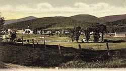
| 23 |
Waumbek Cottages Historic District |
|
02006-03-15-0000March 15, 2006
(#06000142) |
13, 18, 25, and 36 Cottage Rd., and 14 and 38 Starr King Rd.
44°25′01″N 71°28′08″W / 44.416944°N 71.468889°W / 44.416944; -71.468889 (Waumbek Cottages Historic District) |
Jefferson |
|
| 24 |
Weeks Estate |
Upload image |
01985-06-06-0000June 6, 1985
(#85001190) |
US 3
44°27′05″N 71°34′15″W / 44.451389°N 71.570833°W / 44.451389; -71.570833 (Weeks Estate) |
Lancaster |
|
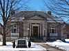
| 25 |
William Dennis Weeks Memorial Library |
|
02000-12-01-0000December 1, 2000
(#00001464) |
128 Main St.
44°29′27″N 71°34′16″W / 44.490833°N 71.571111°W / 44.490833; -71.571111 (William Dennis Weeks Memorial Library) |
Lancaster |
|
| 26 |
Wilder-Holton House |
|
01975-06-11-0000June 11, 1975
(#75000231) |
226 Main St.
44°30′11″N 71°34′41″W / 44.503056°N 71.578056°W / 44.503056; -71.578056 (Wilder-Holton House) |
Lancaster |
|