National Register of Historic Places listings in Conway County, Arkansas
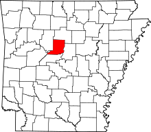
Location of Conway County in Arkansas
This is a list of the National Register of Historic Places listings in Conway County, Arkansas.
This is intended to be a complete list of the properties and districts on the National Register of Historic Places in Conway County, Arkansas, United States. The locations of National Register properties and districts for which the latitude and longitude coordinates are included below, may be seen in a Google map.[1]
There are 51 properties and districts listed on the National Register in the county. Two other sites once listed on the Register have been removed.
- This National Park Service list is complete through NPS recent listings posted May 1, 2015.[2]
Current listings
| [3] | Name on the Register[4] | Image | Date listed[5] | Location | City or town | Description |
|---|---|---|---|---|---|---|
| 1 | Arkansas Christian College Administration Building | 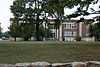 |
(#13001101) |
100 W. Harding St. 35°09′51″N 92°44′36″W / 35.164123°N 92.743223°W |
Morrilton | |
| 2 | Aycock House | 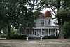 |
(#76000397) |
410 W. Church St. 35°09′06″N 92°45′01″W / 35.151667°N 92.750278°W |
Morrilton | |
| 3 | Cafeteria Building-Cleveland School | Upload image | (#92001194) |
County Road 511 35°23′27″N 92°42′41″W / 35.390833°N 92.711389°W |
Cleveland | |
| 4 | Cedar Creek Bridge | 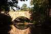 |
(#90000520) |
Off Highway 154, over Cedar Creek at Roosevelt Lake 35°07′43″N 92°55′30″W / 35.128611°N 92.925°W |
Petit Jean State Park | |
| 5 | Coca-Cola Building | 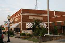 |
(#82000803) |
211 N. Moose 35°09′15″N 92°44′35″W / 35.154167°N 92.743056°W |
Morrilton | |
| 6 | Conway County Courthouse | 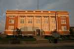 |
(#89001960) |
Moose St. at Church St. 35°09′05″N 92°44′37″W / 35.151389°N 92.743611°W |
Morrilton | |
| 7 | Conway County Library | 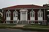 |
(#78000581) |
101 W. Church St. 35°09′04″N 92°44′45″W / 35.151111°N 92.745833°W |
Morrilton | |
| 8 | Cove Creek Bridge | Upload image | (#04000499) |
Highway 124 35°19′23″N 92°29′08″W / 35.323056°N 92.485556°W |
Martinville | |
| 9 | Cox House | Upload image | (#74000471) |
Bridge St. 35°08′30″N 92°44′06″W / 35.141667°N 92.735°W |
Morrilton | |
| 10 | Earl Building | Upload image | (#08001336) |
201 N. St. Joseph St. 35°09′12″N 92°44′28″W / 35.1534°N 92.7411°W |
Morrilton | |
| 11 | First National Bank of Morrilton | 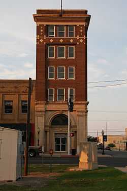 |
(#82000804) |
Main at Moose St. 35°09′10″N 92°44′38″W / 35.152778°N 92.743889°W |
Morrilton | |
| 12 | Grotto, Petit Jean No. 8 | Upload image | (#82002100) |
Address Restricted |
Oppelo | |
| 13 | Hardison Shelter, Petit Jean No. 3 | Upload image | (#82002101) |
Address Restricted |
Oppelo | |
| 14 | Indian Cave, Petit Jean No. 1 | Upload image | (#82002102) |
Address Restricted |
Oppelo | |
| 15 | Little Rock to Cantonment Gibson Road-Old Wire Road Segment | Upload image | (#07001465) |
Address Restricted |
Blackwell | A Trail of Tears site[6] |
| 16 | Mallettown United Methodist Church | Upload image | (#05000041) |
274 Mallett Town Rd. 35°17′02″N 92°29′23″W / 35.283889°N 92.489722°W |
Mallet Town | |
| 17 | Menifee High School Gymnasium | 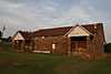 |
(#02000601) |
Junction of N. Park St. and E. Mustang St. 35°08′50″N 92°32′48″W / 35.147222°N 92.546667°W |
Menifee | |
| 18 | Moose Addition Neighborhood Historic District | Upload image | (#13000349) |
Roughly bounded by W. Valley, S. Moose, Green, Brown & S. Division Sts. 35°08′59″N 92°44′49″W / 35.1497°N 92.7470°W |
Morrilton | |
| 19 | Moose House | 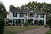 |
(#74000472) |
711 Green St. 35°08′56″N 92°44′15″W / 35.148889°N 92.7375°W |
Morrilton | |
| 20 | Morrilton Colored School | 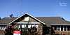 |
(#14000245) |
906 W. Rock St. 35°09′32″N 92°45′14″W / 35.1589°N 92.7539°W |
Morrilton | |
| 21 | Morrilton Commercial Historic District | Upload image | (#03000085) |
Roughly bounded by E. Railroad, Broadway, N. Division, and N. Moose Sts. 35°09′13″N 92°44′39″W / 35.153611°N 92.744167°W |
Morrilton | |
| 22 | Morrilton Post Office | 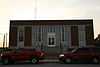 |
(#98000921) |
117 N. Division St. 35°09′14″N 92°44′42″W / 35.153889°N 92.745°W |
Morrilton | |
| 23 | Morrilton Railroad Station | 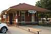 |
(#77000249) |
Railroad Ave. between Division and Moose Sts. 35°08′55″N 92°44′40″W / 35.148611°N 92.744444°W |
Morrilton | |
| 24 | Old US 64, Menifee Segment | Upload image | (#06000071) |
Canal Rd., approximately 0.5 miles southeast of U.S. Route 64 35°08′52″N 92°33′16″W / 35.147778°N 92.554444°W |
Menifee | |
| 25 | Petit Jean No. 4 | Upload image | (#82002105) |
Address Restricted |
Oppelo | |
| 26 | Petit Jean No. 5 | Upload image | (#82002106) |
Address Restricted |
Oppelo | |
| 27 | Petit Jean No. 6 | Upload image | (#82002107) |
Address Restricted |
Oppelo | |
| 28 | Petit Jean No. 7 | Upload image | (#82002108) |
Address Restricted |
Oppelo | |
| 29 | Petit Jean No. 9 | Upload image | (#82002109) |
Address Restricted |
Oppelo | |
| 30 | Petit Jean No. 10 | Upload image | (#82002103) |
Address Restricted |
Oppelo | |
| 31 | Petit Jean No. 11 | Upload image | (#82002104) |
Address Restricted |
Oppelo | |
| 32 | Petit Jean State Park-Administration Office | 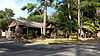 |
(#92000520) |
Highway 154 east of Bench Mark 914 in Petit Jean State Park 35°07′39″N 92°55′09″W / 35.1275°N 92.919167°W |
Winrock | |
| 33 | Petit Jean State Park-Blue Hole Road District | Upload image | (#92000513) |
Blue Hole Rd. in Petit Jean State Park 35°07′17″N 92°57′16″W / 35.121389°N 92.954444°W |
Winrock | |
| 34 | Petit Jean State Park-Cabin No. 1 | 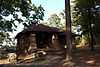 |
(#92000523) |
Campground access road in Petit Jean State Park 35°07′05″N 92°56′13″W / 35.118056°N 92.936944°W |
Winrock | |
| 35 | Petit Jean State Park-Cabin No. 6 | 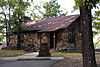 |
(#92000524) |
Campground access road in Petit Jean State Park 35°07′07″N 92°56′15″W / 35.118611°N 92.9375°W |
Winrock | |
| 36 | Petit Jean State Park-Cabin No. 9 | 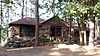 |
(#92000525) |
Campground access road in Petit Jean State Park 35°07′08″N 92°56′20″W / 35.118889°N 92.938889°W |
Winrock | |
| 37 | Petit Jean State Park-Cabin No. 16 | 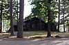 |
(#92000522) |
Campground access road in Petit Jean State Park 35°07′07″N 92°56′21″W / 35.118611°N 92.939167°W |
Winrock | |
| 38 | Petit Jean State Park-Cedar Falls Trail Historic District | 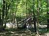 |
(#92000514) |
Adjacent to the main access road in Petit Jean State Park 35°07′01″N 92°56′30″W / 35.116944°N 92.941667°W |
Winrock | |
| 39 | Petit Jean State Park-Concrete Log Bridge | 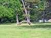 |
(#92000519) |
Highway 154 south of Bench Mark 914 in Petit Jean State Park 35°07′34″N 92°55′29″W / 35.126111°N 92.924722°W |
Winrock | |
| 40 | Petit Jean State Park-Culvert No. 1 | Upload image | (#92000518) |
Highway 154 in Petit Jean State Park 35°07′05″N 92°55′58″W / 35.118056°N 92.932778°W |
Winrock | |
| 41 | Petit Jean State Park-Lake Bailey-Roosevelt Lake Historic District | 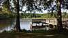 |
(#92000515) |
East and north of Highway 154 in Petit Jean State Park 35°07′45″N 92°54′54″W / 35.129167°N 92.915°W |
Winrock | |
| 42 | Mather Lodge |  |
(#92000521) |
Main access road in Petit Jean State Park 35°07′02″N 92°56′18″W / 35.117222°N 92.938333°W |
Petit Jean State Park | |
| 43 | Petit Jean State Park-Office Headquarters | Upload image | (#92000516) |
Highway 154, approximately 500 feet south of Bench Mark 914 in Petit Jean State Park 35°07′35″N 92°55′34″W / 35.126389°N 92.926111°W |
Winrock | |
| 44 | Petit Jean State Park-Water Treatment Building | Upload image | (#92000517) |
On a dirt access road south of its junction with Highway 154, approximately 800 feet east of Bench Mark 914 in Petit Jean State Park 35°07′31″N 92°55′20″W / 35.125278°N 92.922222°W |
Winrock | |
| 45 | Plumerville School Building |  |
(#92001193) |
Arnold St. 35°09′30″N 92°38′03″W / 35.158333°N 92.634167°W |
Plumerville | |
| 46 | Plummer's Station | Upload image | (#75000378) |
South of Plumerville on Gap Creek 35°09′21″N 92°38′33″W / 35.155833°N 92.6425°W |
Plumerville | |
| 47 | Rockhouse Cave, Petit Jean No. 2 | 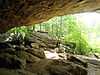 |
(#82002110) |
Address Restricted |
Oppelo | |
| 48 | Saint Anthony's Hospital | 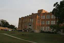 |
(#86000581) |
202 E. Green St. 35°08′51″N 92°44′37″W / 35.1475°N 92.743611°W |
Morrilton | |
| 49 | Seven Hollows-Petit Jean Mountain Site #1 | Upload image | (#06000833) |
Southeast of the junction of Highways 154 and 155 in Petit Jean State Park[7] 35°06′37″N 92°56′53″W / 35.110278°N 92.948056°W |
Winrock | |
| 50 | Sims Hotel | Upload image | (#75000379) |
Center of Plumerville 35°09′29″N 92°38′33″W / 35.158056°N 92.6425°W |
Plumerville | |
| 51 | Trinity Lutheran Church | Upload image | (#76000396) |
7.2 miles south of Atkins off Highway 154 35°07′58″N 92°55′31″W / 35.132778°N 92.925278°W |
Atkins | |
| 52 | W.L. Wood House | 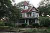 |
(#02000604) |
709 N. Morrill St. 35°09′40″N 92°44′46″W / 35.161111°N 92.746111°W |
Morrilton |
Former listings
| [3] | Name on the Register | Image | Date listed | Date removed | Location | City or town | Summary |
|---|---|---|---|---|---|---|---|
| 1 | Morrilton Male and Female College | Upload image | (#79000436) | E. Church St. |
Morrilton | ||
| 2 | Solgohachia Bridge | |
(#04000498) | County Road 67 35°16′17″N 92°42′48″W / 35.271389°N 92.713333°W |
Solgohachia |
See also
| Wikimedia Commons has media related to National Register of Historic Places in Conway County, Arkansas. |
- List of National Historic Landmarks in Arkansas
- National Register of Historic Places listings in Arkansas
References
- ↑ The latitude and longitude information provided in this table was derived originally from the National Register Information System, which has been found to be fairly accurate for about 99% of listings. For about 1% of NRIS original coordinates, experience has shown that one or both coordinates are typos or otherwise extremely far off; some corrections may have been made. A more subtle problem causes many locations to be off by up to 150 yards, depending on location in the country: most NRIS coordinates were derived from tracing out latitude and longitudes off of USGS topographical quadrant maps created under the North American Datum of 1927, which differs from the current, highly accurate WGS84 GPS system used by most on-line maps. Chicago is about right, but NRIS longitudes in Washington are higher by about 4.5 seconds, and are lower by about 2.0 seconds in Maine. Latitudes differ by about 1.0 second in Florida. Some locations in this table may have been corrected to current GPS standards.
- ↑ "National Register of Historic Places: Weekly List Actions". National Park Service, United States Department of the Interior. Retrieved on May 1, 2015.
- ↑ 3.0 3.1 Numbers represent an ordering by significant words. Various colorings, defined here, differentiate National Historic Landmarks and historic districts from other NRHP buildings, structures, sites or objects.
- ↑ "National Register Information System". National Register of Historic Places. National Park Service. 2009-03-13.
- ↑ The eight-digit number below each date is the number assigned to each location in the National Register Information System database, which can be viewed by clicking the number.
- ↑ "Trail Of Tears National Historic Trail: National Register Research". National Park Service. Retrieved January 22, 2013.
- ↑ Location derived from NRIS-provided coordinates; the NRIS provides the coordinates but lists the site as "Address Restricted".
| ||||||||||||||||||||||||||
| |||||||||||||||||||||||||