National Register of Historic Places listings in Columbia County, Florida
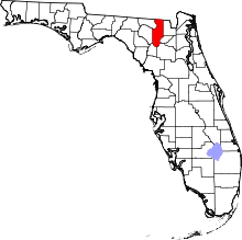
Location of Columbia County in Florida
This is a list of the National Register of Historic Places listings in Columbia County, Florida.
This is intended to be a complete list of the properties and districts on the National Register of Historic Places in Columbia County, Florida, United States. The locations of National Register properties and districts for which the latitude and longitude coordinates are included below, may be seen in a Google map.[1]
There are 11 properties and districts listed on the National Register in the county.
- This National Park Service list is complete through NPS recent listings posted May 1, 2015.[2]
Current listings
| [3] |
Name on the Register[4] |
Image |
Date listed[5] |
Location |
City or town |
Description |
|---|
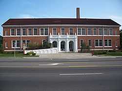
| 1 |
Columbia County High School |
|
01993-11-15-0000November 15, 1993
(#93001154) |
528 West Duval Street
30°11′20″N 82°38′27″W / 30.188889°N 82.640833°W / 30.188889; -82.640833 (Columbia County High School) |
Lake City |
Part of the Lake City MPS
|
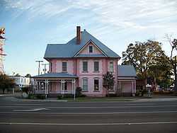
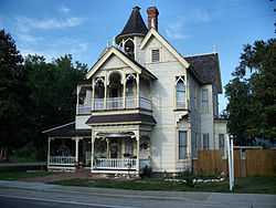
| 2 |
Horace Duncan House |
|
01993-11-15-0000November 15, 1993
(#93001155) |
202 West Duval Street
30°11′19″N 82°38′20″W / 30.188611°N 82.638889°W / 30.188611; -82.638889 (Horace Duncan House) |
Lake City |
Part of the Lake City MPS
|
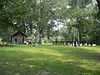
| 3 |
Falling Creek Methodist Church and Cemetery |
|
01996-04-04-0000April 4, 1996
(#96000359) |
State Road 131, 6 miles northwest of Lake City
30°15′32″N 82°39′52″W / 30.258889°N 82.664444°W / 30.258889; -82.664444 (Falling Creek Methodist Church and Cemetery) |
Lake City |
|
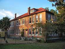
| 4 |
Fort White Public School Historic District |
|
01989-12-01-0000December 1, 1989
(#89002061) |
East Dorch at North Bryant Street
29°55′32″N 82°42′45″W / 29.925556°N 82.7125°W / 29.925556; -82.7125 (Fort White Public School Historic District) |
Fort White |
|
| 5 |
Goodbread-Black Farm Historic District |
Upload image |
01999-04-01-0000April 1, 1999
(#99000409) |
Off Corinth Road, south of the Suwannee River, east of U.S. Route 41, and west of U.S. Route 441
30°18′56″N 82°38′59″W / 30.315556°N 82.649722°W / 30.315556; -82.649722 (Goodbread-Black Farm Historic District) |
Lake City |
|
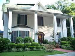
| 6 |
T. G. Henderson House |
|
01973-07-24-0000July 24, 1973
(#73000571) |
207 South Marion Street
30°11′15″N 82°38′14″W / 30.1875°N 82.637222°W / 30.1875; -82.637222 (T. G. Henderson House) |
Lake City |
|
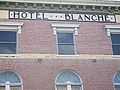
| 7 |
Hotel Blanche |
|
01990-01-18-0000January 18, 1990
(#89002320) |
212 North Marion Street
30°11′27″N 82°38′16″W / 30.190833°N 82.637778°W / 30.190833; -82.637778 (Hotel Blanche) |
Lake City |
|
| 8 |
Lake City Historic Commercial District |
|
01994-06-06-0000June 6, 1994
(#93001157) |
Roughly bounded by Railroad, North Hernando, Duval, and North Columbia Streets
30°11′32″N 82°38′14″W / 30.192222°N 82.637222°W / 30.192222; -82.637222 (Lake City Historic Commercial District) |
Lake City |
Part of the Lake City MPS
|
| 9 |
Lake Isabella Historic Residential District |
|
01993-11-15-0000November 15, 1993
(#93001156) |
Roughly bounded by East, Duval, and Columbia Streets, Baya Avenue, Church Street, and Lake Isabella
30°11′09″N 82°38′04″W / 30.185833°N 82.634444°W / 30.185833; -82.634444 (Lake Isabella Historic Residential District) |
Lake City |
Part of the Lake City MPS
|
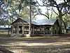
| 10 |
O'Leno State Park |
|
02014-06-09-0000June 9, 2014
(#14000282) |
410 SE. O'Leno Park Rd.
29°55′18″N 82°36′31″W / 29.921613°N 82.608634°W / 29.921613; -82.608634 (O'Leno State Park) |
High Springs |
|
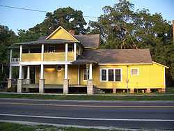
| 11 |
Sikes House |
|
02007-02-01-0000February 1, 2007
(#06001318) |
288 Ellis Street, just south of U.S. Route 27
29°55′21″N 82°42′48″W / 29.9225°N 82.713333°W / 29.9225; -82.713333 (Sikes House) |
Fort White |
|
See also
References
- ↑ The latitude and longitude information provided in this table was derived originally from the National Register Information System, which has been found to be fairly accurate for about 99% of listings. For about 1% of NRIS original coordinates, experience has shown that one or both coordinates are typos or otherwise extremely far off; some corrections may have been made. A more subtle problem causes many locations to be off by up to 150 yards, depending on location in the country: most NRIS coordinates were derived from tracing out latitude and longitudes off of USGS topographical quadrant maps created under the North American Datum of 1927, which differs from the current, highly accurate WGS84 GPS system used by most on-line maps. Chicago is about right, but NRIS longitudes in Washington are higher by about 4.5 seconds, and are lower by about 2.0 seconds in Maine. Latitudes differ by about 1.0 second in Florida. Some locations in this table may have been corrected to current GPS standards.
- ↑ "National Register of Historic Places: Weekly List Actions". National Park Service, United States Department of the Interior. Retrieved on May 1, 2015.
- ↑ Numbers represent an ordering by significant words. Various colorings, defined here, differentiate National Historic Landmarks and historic districts from other NRHP buildings, structures, sites or objects.
- ↑ "National Register Information System". National Register of Historic Places. National Park Service. 2009-03-13.
- ↑ The eight-digit number below each date is the number assigned to each location in the National Register Information System database, which can be viewed by clicking the number.
|
|---|
| | Lists by county | | |
|---|
| | Lists by city | |
|---|
| | Other lists | |
|---|
| |
|