National Register of Historic Places listings in Columbia County, Arkansas
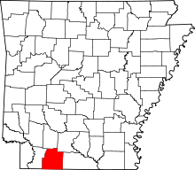
Location of Columbia County in Arkansas
This is a list of the National Register of Historic Places listings in Columbia County, Arkansas.
This is intended to be a complete list of the properties and districts on the National Register of Historic Places in Columbia County, Arkansas, United States. The locations of National Register properties and districts for which the latitude and longitude coordinates are included below, may be seen in a Google map.[1]
There are 20 properties and districts listed on the National Register in the county.
Contents: Counties in Arkansas
|
|
- This National Park Service list is complete through NPS recent listings posted May 1, 2015.[2]
Current listings
| [3] |
Name on the Register[4] |
Image |
Date listed[5] |
Location |
City or town |
Description |
|---|
| 1 |
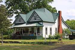
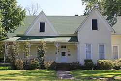
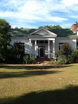
W. H. Allen House |
|
01976-10-14-0000October 14, 1976
(#76000395) |
Northwest of Spotville off Highway 98
33°11′31″N 93°01′25″W / 33.191944°N 93.023611°W / 33.191944; -93.023611 (W. H. Allen House) |
Spotville |
|
| 2 |
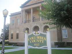
Columbia County Courthouse |
|
01978-04-15-0000April 15, 1978
(#78000580) |
Court Sq.
33°16′01″N 93°14′27″W / 33.266944°N 93.240833°W / 33.266944; -93.240833 (Columbia County Courthouse) |
Magnolia |
|
| 3 |
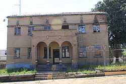
Columbia County Jail |
|
01982-12-22-0000December 22, 1982
(#82000802) |
Calhoun and Jefferson Sts.
33°15′55″N 93°14′30″W / 33.265278°N 93.241667°W / 33.265278; -93.241667 (Columbia County Jail) |
Magnolia |
|
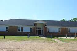
| 4 |
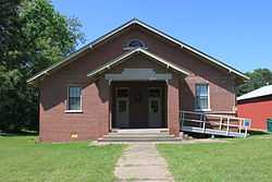
Harvey C. Couch School |
|
01993-06-08-0000June 8, 1993
(#93000482) |
Northeast of the junction of County Roads 11 (Calhoun Rd.) and 25
33°13′12″N 93°09′12″W / 33.22°N 93.153333°W / 33.22; -93.153333 (Harvey C. Couch School) |
Calhoun |
|
| 5 |
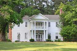
Couch-Marshall House |
|
01992-07-24-0000July 24, 1992
(#92000955) |
505 W. Monroe St.
33°15′56″N 93°14′41″W / 33.265556°N 93.244722°W / 33.265556; -93.244722 (Couch-Marshall House) |
Magnolia |
|
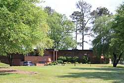
| 6 |
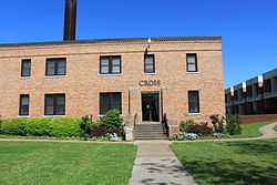
Cross and Nelson Hall Historic District |
|
02010-01-20-0000January 20, 2010
(#09001240) |
Southern Arkansas University campus at 100 E. University
33°17′25″N 93°14′07″W / 33.290272°N 93.235239°W / 33.290272; -93.235239 (Cross and Nelson Hall Historic District) |
Magnolia |
|
| 7 |
Dolph Camp, Bussey and Peace Halls Historic District |
|
02013-01-29-0000January 29, 2013
(#12001231) |
East side of Lane Dr., Southern Arkansas University
33°17′26″N 93°14′03″W / 33.290503°N 93.234274°W / 33.290503; -93.234274 (Dolph Camp, Bussey and Peace Halls Historic District) |
Magnolia |
|
| 8 |
Frog Level |
|
01972-09-22-0000September 22, 1972
(#72000201) |
West of Magnolia off Columbia Rd.[6]
33°16′44″N 93°21′13″W / 33.278889°N 93.353542°W / 33.278889; -93.353542 (Frog Level) |
Bussey |
|
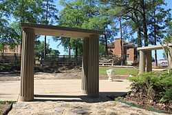
| 9 |
Greek Amphitheatre |
|
02005-06-01-0000June 1, 2005
(#05000488) |
Junction of East Lane Dr., E. University St., and Crescent Dr.
33°17′27″N 93°14′04″W / 33.290833°N 93.234444°W / 33.290833; -93.234444 (Greek Amphitheatre) |
Magnolia |
|
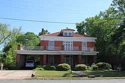
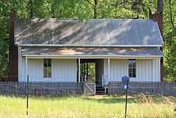
| 10 |
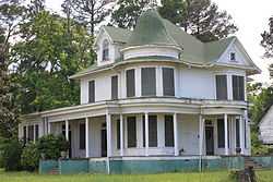
Dr. H.A. Longino House |
|
01982-06-14-0000June 14, 1982
(#82002098) |
317 W. Main St.
33°16′00″N 93°14′36″W / 33.266667°N 93.243333°W / 33.266667; -93.243333 (Dr. H.A. Longino House) |
Magnolia |
|
| 11 |
Magnolia Colored School Historic District |
|
02014-01-22-0000January 22, 2014
(#13001103) |
611 S. Madison
33°15′43″N 93°14′37″W / 33.26202°N 93.243602°W / 33.26202; -93.243602 (Magnolia Colored School Historic District) |
Magnolia |
|
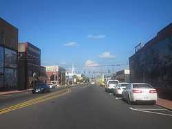
| 12 |
Magnolia Commercial Historic District |
|
02008-05-20-0000May 20, 2008
(#08000435) |
Roughly bounded by Madison Ave., Calhoun St., Jackson Ave., and Union St.
33°16′02″N 93°14′27″W / 33.267125°N 93.240831°W / 33.267125; -93.240831 (Magnolia Commercial Historic District) |
Magnolia |
|
| 13 |
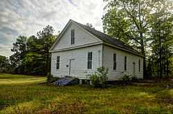
Mt. Prospect Methodist Church |
|
01990-03-22-0000March 22, 1990
(#90000428) |
Junction of County Roads 61 and 446
33°22′09″N 93°04′32″W / 33.369167°N 93.075556°W / 33.369167; -93.075556 (Mt. Prospect Methodist Church) |
Richland |
|
| 14 |
Old Alexander House |
Upload image |
01979-01-18-0000January 18, 1979
(#79000435) |
Northeast of Magnolia
33°19′24″N 93°08′26″W / 33.323333°N 93.140556°W / 33.323333; -93.140556 (Old Alexander House) |
Magnolia |
|
| 15 |
Ozmer House |
|
01986-11-20-0000November 20, 1986
(#86003226) |
Southern Arkansas University farm, U.S. Route 82 Bypass
33°17′16″N 93°13′13″W / 33.287778°N 93.220278°W / 33.287778; -93.220278 (Ozmer House) |
Magnolia |
|
| 16 |
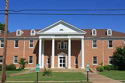
President's House |
|
02013-05-28-0000May 28, 2013
(#13000315) |
East Farm Road east of Washington Street, Southern Arkansas University
33°17′45″N 93°13′59″W / 33.295970°N 93.233050°W / 33.295970; -93.233050 (President's House) |
Magnolia |
|
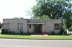
| 17 |
The Rushton Clinic |
|
02013-05-28-0000May 28, 2013
(#13000316) |
219 North Washington Street
33°16′09″N 93°14′26″W / 33.269081°N 93.240452°W / 33.269081; -93.240452 (The Rushton Clinic) |
Magnolia |
|
| 18 |
William H. Smith House |
|
01992-11-27-0000November 27, 1992
(#92001630) |
North of the junction of Highway 98 and County Road 85
33°07′12″N 93°03′12″W / 33.12°N 93.053333°W / 33.12; -93.053333 (William H. Smith House) |
Atlanta |
|
| 19 |
Kate Turner House |
|
01982-08-26-0000August 26, 1982
(#82002099) |
709 W. Main St.
33°16′00″N 93°14′53″W / 33.266667°N 93.248056°W / 33.266667; -93.248056 (Kate Turner House) |
Magnolia |
|
| 20 |
Waldo Water Tower |
Upload image |
02007-05-29-0000May 29, 2007
(#07000472) |
E. Main St., west of its junction with N. Skimmer
33°21′11″N 93°16′56″W / 33.353056°N 93.282222°W / 33.353056; -93.282222 (Waldo Water Tower) |
Waldo |
|
Former listings
| [3] |
Name on the Register |
Image |
Date listed | Date removed |
Location |
City or town |
Summary |
|---|
| 1 |
Bank of Waldo |
Upload image |
01982-01-01-00001982
(#82000801) | 01999-09-17-0000September 17, 1999 |
Locust and Main Sts.
|
Waldo |
|
| 2 |
Caraway Hall |
Upload image |
01993-01-01-00001993
(#93000088) | 01999-08-11-0000August 11, 1999 |
Southern Arkansas University, Adjacent to E. Lane Dr.
|
Magnolia |
|
| 3 |
Louisiana and Northwest Railroad Depot - Magnolia |
Upload image |
01993-01-01-00001993
(#92000614) | 02000-03-31-0000March 31, 2000 |
N side of Main St., between Clay and Walnut Sts.
|
Magnolia |
|
See also
References
- ↑ The latitude and longitude information provided in this table was derived originally from the National Register Information System, which has been found to be fairly accurate for about 99% of listings. For about 1% of NRIS original coordinates, experience has shown that one or both coordinates are typos or otherwise extremely far off; some corrections may have been made. A more subtle problem causes many locations to be off by up to 150 yards, depending on location in the country: most NRIS coordinates were derived from tracing out latitude and longitudes off of USGS topographical quadrant maps created under the North American Datum of 1927, which differs from the current, highly accurate WGS84 GPS system used by most on-line maps. Chicago is about right, but NRIS longitudes in Washington are higher by about 4.5 seconds, and are lower by about 2.0 seconds in Maine. Latitudes differ by about 1.0 second in Florida. Some locations in this table may have been corrected to current GPS standards.
- ↑ "National Register of Historic Places: Weekly List Actions". National Park Service, United States Department of the Interior. Retrieved on May 1, 2015.
- ↑ 3.0 3.1 Numbers represent an ordering by significant words. Various colorings, defined here, differentiate National Historic Landmarks and historic districts from other NRHP buildings, structures, sites or objects.
- ↑ "National Register Information System". National Register of Historic Places. National Park Service. 2009-03-13.
- ↑ The eight-digit number below each date is the number assigned to each location in the National Register Information System database, which can be viewed by clicking the number.
- ↑ Location derived from NRIS-provided coords; the NRIS lists the site as "Address unknown at this time".
|
|---|
| | Topics | |
|---|
| | Lists by states | |
|---|
| | Lists by insular areas | |
|---|
| | Lists by associated states | |
|---|
| | Other areas | |
|---|
|
-
 Category Category
-
 Portal Portal
-
 WikiProject WikiProject
|
|