National Register of Historic Places listings in Collier County, Florida
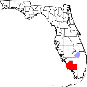
Location of Collier County in Florida
This is a list of the National Register of Historic Places listings in Collier County, Florida.
This is intended to be a complete list of the properties and districts on the National Register of Historic Places in Collier County, Florida, United States. The locations of National Register properties and districts for which the latitude and longitude coordinates are included below, may be seen in a map.[1]
There are 20 properties and districts listed on the National Register in the county.
- This National Park Service list is complete through NPS recent listings posted May 1, 2015.[2]
Current listings
| [3] |
Name on the Register[4] |
Image |
Date listed[5] |
Location |
City or town |
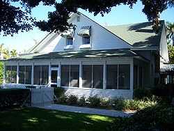
Description |
|---|
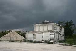
| 1 |
Bank of Everglades Building |
|
01999-07-15-0000July 15, 1999
(#99000825) |
201 West Broadway
25°51′27″N 81°23′13″W / 25.8575°N 81.386944°W / 25.8575; -81.386944 (Bank of Everglades Building) |
Everglades City |
|
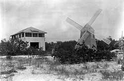
| 2 |
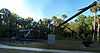
Bay City Walking Dredge |
|
02013-05-29-0000May 29, 2013
(#13000318) |
20200 E. Tamiami Trail
25°59′31″N 81°35′36″W / 25.991839°N 81.593211°W / 25.991839; -81.593211 (Bay City Walking Dredge) |
Naples |
On display at Collier-Seminole State Park.
|
| 3 |
Burns Lake Site (8CR259) |
Upload image |
01986-05-27-0000May 27, 1986
(#86001192) |
Address Restricted
|
Ochopee |
|
| 4 |
Everglades Laundry |
|
02001-09-22-0000September 22, 2001
(#01001012) |
105 West Broadway
25°51′24″N 81°23′08″W / 25.856667°N 81.385556°W / 25.856667; -81.385556 (Everglades Laundry) |
Everglades City |
|
| 5 |
Halfway Creek Site |
Upload image |
01980-08-15-0000August 15, 1980
(#80000365) |
Address Restricted
|
Carnestown |
|
| 6 |
Hinson Mounds |
Upload image |
01978-12-29-0000December 29, 1978
(#78000345) |
Address Restricted
|
Miles City |
|
| 7 |
Capt. John Foley Horr House |
|
01997-10-08-0000October 8, 1997
(#97001215) |
Northern side of Whiskey Creek Drive
25°54′12″N 81°41′16″W / 25.903333°N 81.687778°W / 25.903333; -81.687778 (Capt. John Foley Horr House) |
Key Marco |
|
| 8 |
Keewaydin Club |
|
01987-12-22-0000December 22, 1987
(#87001979) |
Northern end of Key Island
26°05′23″N 81°48′02″W / 26.089722°N 81.800556°W / 26.089722; -81.800556 (Keewaydin Club) |
Naples |
|
| 9 |
Monroe Station |
|
02000-05-11-0000May 11, 2000
(#00000427) |
Junction of the Tamiami Trail and Loop Road
25°51′46″N 81°06′01″W / 25.862778°N 81.100278°W / 25.862778; -81.100278 (Monroe Station) |
Ochopee |
|
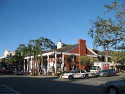
| 10 |
Naples Historic District |
|
01987-12-17-0000December 17, 1987
(#87002179) |
Roughly bounded by Ninth Avenue South, Third Street, Thirteenth Avenue South, and the Gulf of Mexico
26°08′00″N 81°48′17″W / 26.133333°N 81.804722°W / 26.133333; -81.804722 (Naples Historic District) |
Naples |
|
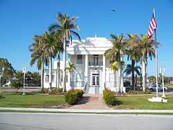
| 11 |
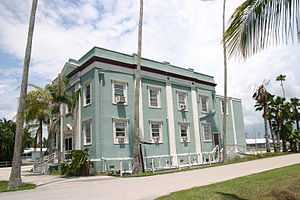
Old Collier County Courthouse |
|
02013-12-03-0000December 3, 2013
(#13000875) |
102 Copeland Ave., N.
25°51′27″N 81°23′05″W / 25.857582°N 81.384742°W / 25.857582; -81.384742 (Old Collier County Courthouse) |
Everglades City |
|
| 12 |
C. J. Ostl Site |
Upload image |
01978-12-15-0000December 15, 1978
(#78003380) |
Address Restricted
|
Ochopee |
|
| 13 |
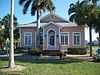
Palm Cottage |
|
01982-05-24-0000May 24, 1982
(#82002371) |
137 12th Avenue, South
26°07′54″N 81°48′15″W / 26.131667°N 81.804167°W / 26.131667; -81.804167 (Palm Cottage) |
Naples |
|
| 14 |
Platt Island |
Upload image |
01978-12-14-0000December 14, 1978
(#78000934) |
Northeast of Miles City off State Road 29[6]
26°12′46″N 81°44′15″W / 26.212778°N 81.737500°W / 26.212778; -81.737500 (Platt Island) |
Miles City |
|
| 15 |
Plaza Site (8CR303) |
Upload image |
01986-05-28-0000May 28, 1986
(#86001196) |
Address Restricted
|
Ochopee |
|
| 16 |
Roberts Ranch |
|
02003-10-04-0000October 4, 2003
(#03000990) |
1215 Roberts Avenue
26°25′15″N 81°25′54″W / 26.420833°N 81.431667°W / 26.420833; -81.431667 (Roberts Ranch) |
Immokalee |
|
| 17 |
Seaboard Coast Line Railroad Depot |
|
01974-09-10-0000September 10, 1974
(#74000613) |
1051 5th Avenue, South
26°08′33″N 81°47′36″W / 26.1425°N 81.793333°W / 26.1425; -81.793333 (Seaboard Coast Line Railroad Depot) |
Naples |
|
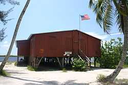
| 18 |
Ted Smallwood Store |
|
01974-07-24-0000July 24, 1974
(#74000612) |
State Road 29 in Everglades National Park
25°48′34″N 81°21′45″W / 25.809444°N 81.3625°W / 25.809444; -81.3625 (Ted Smallwood Store) |
Chokoloskee |
|
| 19 |
Sugar Pot Site |
Upload image |
01978-12-15-0000December 15, 1978
(#78000264) |
Address Restricted
|
Ochopee |
|
| 20 |
Turner River Site |
Upload image |
01978-12-14-0000December 14, 1978
(#78000263) |
Address Restricted
|
Ochopee |
|
See also
References
- ↑ The latitude and longitude information provided in this table was derived originally from the National Register Information System, which has been found to be fairly accurate for about 99% of listings. For about 1% of NRIS original coordinates, experience has shown that one or both coordinates are typos or otherwise extremely far off; some corrections may have been made. A more subtle problem causes many locations to be off by up to 150 yards, depending on location in the country: most NRIS coordinates were derived from tracing out latitude and longitudes off of USGS topographical quadrant maps created under the North American Datum of 1927, which differs from the current, highly accurate WGS84 GPS system used by most on-line maps. Chicago is about right, but NRIS longitudes in Washington are higher by about 4.5 seconds, and are lower by about 2.0 seconds in Maine. Latitudes differ by about 1.0 second in Florida. Some locations in this table may have been corrected to current GPS standards.
- ↑ "National Register of Historic Places: Weekly List Actions". National Park Service, United States Department of the Interior. Retrieved on May 1, 2015.
- ↑ Numbers represent an ordering by significant words. Various colorings, defined here, differentiate National Historic Landmarks and historic districts from other NRHP buildings, structures, sites or objects.
- ↑ "National Register Information System". National Register of Historic Places. National Park Service. 2009-03-13.
- ↑ The eight-digit number below each date is the number assigned to each location in the National Register Information System database, which can be viewed by clicking the number.
- ↑ Location derived from its GNIS feature record; the NRIS lists the site as "Address restricted"
|
|---|
| | Lists by county | | |
|---|
| | Lists by city | |
|---|
| | Other lists | |
|---|
| |
|