National Register of Historic Places listings in Cloud County, Kansas

Location of Cloud County in Kansas
This is a list of the National Register of Historic Places listings in Cloud County, Kansas.
This is intended to be a complete list of the properties and districts on the National Register of Historic Places in Cloud County, Kansas, United States. The locations of National Register properties and districts for which the latitude and longitude coordinates are included below, may be seen in a Google map.[1]
There are 10 properties and districts listed on the National Register in the county.
- This National Park Service list is complete through NPS recent listings posted May 1, 2015.[2]
Current listings
| [3] |
Name on the Register[4] |
Image |
Date listed[5] |
Location |
City or town |
Description |
|---|
| 1 |
Bankers Loan and Trust Company Building |
|
01977-11-09-0000November 9, 1977
(#77000576) |
101 E. 6th and 517 Broadway
39°34′18″N 97°39′31″W / 39.571667°N 97.658611°W / 39.571667; -97.658611 (Bankers Loan and Trust Company Building) |
Concordia |
|
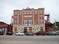
| 2 |
Brown Grand Opera House |
|
01973-07-26-0000July 26, 1973
(#73000747) |
310 W. 6th St.
39°34′17″N 97°39′46″W / 39.571389°N 97.662778°W / 39.571389; -97.662778 (Brown Grand Opera House) |
Concordia |
|
| 3 |
Clyde School |
Upload image |
02009-01-22-0000January 22, 2009
(#08001348) |
620 Broadway St.
39°35′25″N 97°24′11″W / 39.590244°N 97.403022°W / 39.590244; -97.403022 (Clyde School) |
Clyde |
|
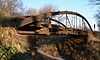
| 4 |
County Line Bowstring |
|
01990-01-04-0000January 4, 1990
(#89002192) |
Over West Creek, northwest of Hollis
39°39′12″N 97°34′21″W / 39.653333°N 97.5725°W / 39.653333; -97.5725 (County Line Bowstring) |
Hollis |
|
| 5 |
Glasco Downtown Historic District |
Upload image |
02002-11-17-0000November 17, 2002
(#02001307) |
Roughly along Main St. from Railroad Ave. to Fisher St., and along Railroad Ave. and Fisher St. between Main and Buffalo Sts.
39°21′40″N 97°50′23″W / 39.361111°N 97.839722°W / 39.361111; -97.839722 (Glasco Downtown Historic District) |
Glasco |
|
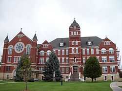
| 6 |
Nazareth Convent and Academy |
|
01973-01-18-0000January 18, 1973
(#73000748) |
13th and Washington Sts.
39°33′49″N 97°39′38″W / 39.563611°N 97.660556°W / 39.563611; -97.660556 (Nazareth Convent and Academy) |
Concordia |
|
| 7 |
Pott's Ford Bridge |
Upload image |
01990-01-04-0000January 4, 1990
(#89002173) |
Over Solomon River, southeast of Glasco
39°21′01″N 97°51′15″W / 39.350278°N 97.854167°W / 39.350278; -97.854167 (Pott's Ford Bridge) |
Glasco |
|
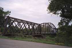
| 8 |
Republican River Pegram Truss |
|
01990-01-04-0000January 4, 1990
(#89002190) |
Route 795 over the Republican River
39°35′46″N 97°34′16″W / 39.596111°N 97.571111°W / 39.596111; -97.571111 (Republican River Pegram Truss) |
Concordia |
|
| 9 |
Union Pacific Railroad Depot |
|
02004-01-21-0000January 21, 2004
(#03001465) |
300 Washington St.
39°34′24″N 97°39′41″W / 39.573333°N 97.661389°W / 39.573333; -97.661389 (Union Pacific Railroad Depot) |
Concordia |
|
| 10 |
Charles W. Van De Mark House |
Upload image |
01985-07-05-0000July 5, 1985
(#85001492) |
504 Washington
39°35′27″N 97°24′01″W / 39.590833°N 97.400278°W / 39.590833; -97.400278 (Charles W. Van De Mark House) |
Clyde |
|
See also
References
- ↑ The latitude and longitude information provided in this table was derived originally from the National Register Information System, which has been found to be fairly accurate for about 99% of listings. For about 1% of NRIS original coordinates, experience has shown that one or both coordinates are typos or otherwise extremely far off; some corrections may have been made. A more subtle problem causes many locations to be off by up to 150 yards, depending on location in the country: most NRIS coordinates were derived from tracing out latitude and longitudes off of USGS topographical quadrant maps created under the North American Datum of 1927, which differs from the current, highly accurate WGS84 GPS system used by most on-line maps. Chicago is about right, but NRIS longitudes in Washington are higher by about 4.5 seconds, and are lower by about 2.0 seconds in Maine. Latitudes differ by about 1.0 second in Florida. Some locations in this table may have been corrected to current GPS standards.
- ↑ "National Register of Historic Places: Weekly List Actions". National Park Service, United States Department of the Interior. Retrieved on May 1, 2015.
- ↑ Numbers represent an ordering by significant words. Various colorings, defined here, differentiate National Historic Landmarks and historic districts from other NRHP buildings, structures, sites or objects.
- ↑ "National Register Information System". National Register of Historic Places. National Park Service. 2009-03-13.
- ↑ The eight-digit number below each date is the number assigned to each location in the National Register Information System database, which can be viewed by clicking the number.
.JPG)