National Register of Historic Places listings in Clinton County, Ohio

Location of Clinton County in Ohio
This is a list of the National Register of Historic Places listings in Clinton County, Ohio.
This is intended to be a complete list of the properties and districts on the National Register of Historic Places in Clinton County, Ohio, United States. The locations of National Register properties and districts for which the latitude and longitude coordinates are included below, may be seen in a Google map.[1]
There are 18 properties and districts listed on the National Register in the county. Another property was once listed but has been removed.
- This National Park Service list is complete through NPS recent listings posted May 1, 2015.[2]
Current listings
| [3] |
Name on the Register[4] |
Image |
Date listed[5] |
Location |
City or town |
Description |
|---|
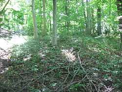
| 1 |
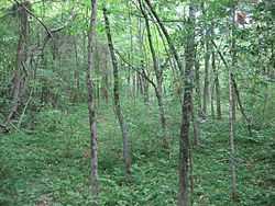
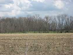
Beam Farm Woodland Archeological District |
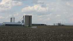
|
02006-03-22-0000March 22, 2006
(#05000340) |
3983 Stone Rd., southwest of Sabina[6]
39°29′56″N 83°42′32″W / 39.498889°N 83.708889°W / 39.498889; -83.708889 (Beam Farm Woodland Archeological District) |
Wilson Township |
|
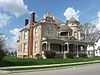
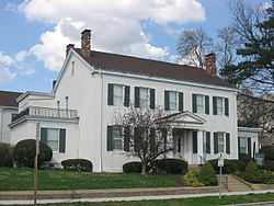
| 2 |
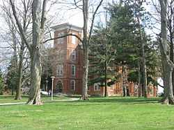
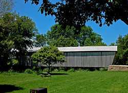
College Hall, Wilmington College |
|
01973-04-23-0000April 23, 1973
(#73001399) |
East of College St. between Douglas St. and Fife Ave. on the Wilmington College campus
39°26′41″N 83°49′06″W / 39.444722°N 83.818333°W / 39.444722; -83.818333 (College Hall, Wilmington College) |
Wilmington |
|
| 3 |
Cowan Creek Circular Enclosure |
|
01974-07-15-0000July 15, 1974
(#74001422) |
Southwest of Wilmington
39°23′24″N 83°54′37″W / 39.390000°N 83.910278°W / 39.390000; -83.910278 (Cowan Creek Circular Enclosure) |
Vernon Township |
|
| 4 |
Doan House |
|
01979-06-20-0000June 20, 1979
(#79001792) |
822 Fife Ave.
39°26′41″N 83°48′53″W / 39.444722°N 83.814722°W / 39.444722; -83.814722 (Doan House) |
Wilmington |
|
| 5 |
Frank Haines House |
|
01982-04-01-0000April 1, 1982
(#82003556) |
149 W. Elm St.
39°29′23″N 83°38′20″W / 39.489722°N 83.638889°W / 39.489722; -83.638889 (Frank Haines House) |
Sabina |
|
| 6 |
Eli Harvey House |
|
01978-02-14-0000February 14, 1978
(#78002024) |
1133 Lebanon Rd., north of Clarksville
39°26′36″N 83°57′37″W / 39.443333°N 83.960278°W / 39.443333; -83.960278 (Eli Harvey House) |
Adams Township |
|
| 7 |
Hillside Haven Mound |
|
01978-11-21-0000November 21, 1978
(#78002026) |
Thousand Trails Campground, 1786 State Route 380[7]:14
39°27′30″N 83°56′14″W / 39.458333°N 83.937222°W / 39.458333; -83.937222 (Hillside Haven Mound) |
Adams Township |
|
| 8 |
Hurley Mound |
|
01978-05-05-0000May 5, 1978
(#78002025) |
East of McKay Rd. above the Anderson Fork, southwest of Lumberton[7]:15
39°33′04″N 83°51′49″W / 39.551111°N 83.863611°W / 39.551111; -83.863611 (Hurley Mound) |
Liberty Township |
|
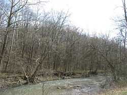
| 9 |
Keiter Mound |
|
01975-10-21-0000October 21, 1975
(#75001346) |
In woods west of McKay Rd., atop a bluff overlooking the Anderson Fork[7]:15
39°32′52″N 83°52′46″W / 39.547916°N 83.879583°W / 39.547916; -83.879583 (Keiter Mound) |
Liberty Township |
|
| 10 |
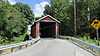
Lynchburg Covered Bridge |
|
01976-03-16-0000March 16, 1976
(#76001456) |
East Fork of Little Miami River
39°14′42″N 83°47′40″W / 39.245°N 83.794444°W / 39.245; -83.794444 (Lynchburg Covered Bridge) |
Lynchburg |
Extends into Highland County
|
| 11 |
Main Building School |
|
01980-11-21-0000November 21, 1980
(#80002960) |
Sugartree St.
39°26′36″N 83°50′04″W / 39.443333°N 83.834444°W / 39.443333; -83.834444 (Main Building School) |
Wilmington |
Demolished
|
| 12 |
Martinsville Road Covered Bridge |
|
01974-09-10-0000September 10, 1974
(#74001421) |
West of Martinsville
39°19′47″N 83°50′06″W / 39.329722°N 83.835°W / 39.329722; -83.835 (Martinsville Road Covered Bridge) |
Clark Township |
|
| 13 |
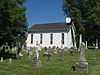
Pansy Methodist Church and School Historic District |
|
01973-03-20-0000March 20, 1973
(#73001398) |
South of Clarksville on State Route 730
39°20′55″N 83°56′41″W / 39.348611°N 83.944722°W / 39.348611; -83.944722 (Pansy Methodist Church and School Historic District) |
Vernon Township |
|
| 14 |
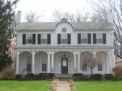
Rombach Place |
|
01979-06-20-0000June 20, 1979
(#79001793) |
149 E. Locust St.
39°26′48″N 83°49′33″W / 39.446667°N 83.825833°W / 39.446667; -83.825833 (Rombach Place) |
Wilmington |
|
| 15 |
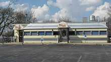
Silk City Diner #4655 |
|
02005-08-10-0000August 10, 2005
(#05000848) |
303 Washington St.
39°29′16″N 83°38′31″W / 39.487778°N 83.641944°W / 39.487778; -83.641944 (Silk City Diner #4655) |
Sabina |
|
| 16 |
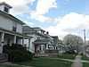
South South Street Historic District |
|
01993-05-06-0000May 6, 1993
(#93000396) |
151-515 S. South St.
39°26′32″N 83°49′45″W / 39.442222°N 83.829222°W / 39.442222; -83.829222 (South South Street Historic District) |
Wilmington |
|
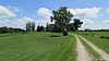
| 17 |
Underwood Farms Rural Historic District |
|
02006-01-11-0000January 11, 2006
(#05001519) |
Vicinity of State Route 73 and Brimstone Rd.
39°29′47″N 83°58′50″W / 39.496389°N 83.980556°W / 39.496389; -83.980556 (Underwood Farms Rural Historic District) |
Chester Township |
|
| 18 |
Wilmington Commercial Historic District |
|
01982-10-14-0000October 14, 1982
(#82001363) |
Roughly bounded by Columbus, Walnut, Sugartree, and Mulberry Sts.
39°26′44″N 83°49′44″W / 39.445556°N 83.828889°W / 39.445556; -83.828889 (Wilmington Commercial Historic District) |
Wilmington |
|
Former listing
| [3] |
Name on the Register |
Image |
Date listed | Date removed |
Location |
City or town |
Summary |
|---|
| 1 |
Smith Place School |
Upload image |
01980-11-25-0000November 25, 1980
(#80002961) | 01985-10-29-0000October 29, 1985 |
N. South St.
|
Wilmington |
|
See also
References
- ↑ The latitude and longitude information provided in this table was derived originally from the National Register Information System, which has been found to be fairly accurate for about 99% of listings. For about 1% of NRIS original coordinates, experience has shown that one or both coordinates are typos or otherwise extremely far off; some corrections may have been made. A more subtle problem causes many locations to be off by up to 150 yards, depending on location in the country: most NRIS coordinates were derived from tracing out latitude and longitudes off of USGS topographical quadrant maps created under the North American Datum of 1927, which differs from the current, highly accurate WGS84 GPS system used by most on-line maps. Chicago is about right, but NRIS longitudes in Washington are higher by about 4.5 seconds, and are lower by about 2.0 seconds in Maine. Latitudes differ by about 1.0 second in Florida. Some locations in this table may have been corrected to current GPS standards.
- ↑ "National Register of Historic Places: Weekly List Actions". National Park Service, United States Department of the Interior. Retrieved on May 1, 2015.
- ↑ 3.0 3.1 Numbers represent an ordering by significant words. Various colorings, defined here, differentiate National Historic Landmarks and historic districts from other NRHP buildings, structures, sites or objects.
- ↑ "National Register Information System". National Register of Historic Places. National Park Service. 2008-04-24.
- ↑ The eight-digit number below each date is the number assigned to each location in the National Register Information System database, which can be viewed by clicking the number.
- ↑ Location derived from this Ohio Historical Society webpage; the NRIS lists the site as "Address Restricted"
- ↑ 7.0 7.1 7.2 Koleszar, Stephen C. An Archaeological Survey of Southwestern Ohio. Columbus: Ohio Historical Society, 1970.
|
|---|
| | Lists by county | | |
|---|
| | Lists by city | |
|---|
| | Other lists | |
|---|
| |
|