| [3] |
Name on the Register |
Image |
Date listed[4] |
Location |
City or town |
Description |
|---|
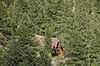
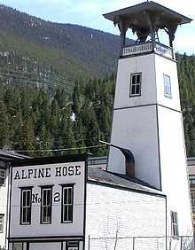
| 1 |
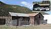
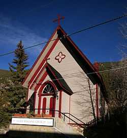
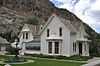
Alpine Hose Company No. 2 |
|
01973-01-25-0000January 25, 1973
(#73000464) |
507 5th St.
39°42′19″N 105°41′48″W / 39.705278°N 105.696667°W / 39.705278; -105.696667 (Alpine Hose Company No. 2) |
Georgetown |
|
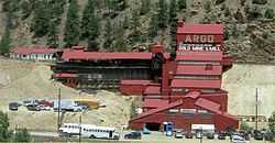
| 2 |
Argo Tunnel and Mill |
|
01978-01-31-0000January 31, 1978
(#78000836) |
2517 Riverside Dr.
39°44′35″N 105°30′17″W / 39.743056°N 105.504722°W / 39.743056; -105.504722 (Argo Tunnel and Mill) |
Idaho Springs |
|
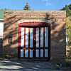
| 3 |
Bryan Hose House |
|
01998-03-19-0000March 19, 1998
(#98000174) |
Junction of Illinois and Virginia Sts.
39°44′37″N 105°30′46″W / 39.743611°N 105.512778°W / 39.743611; -105.512778 (Bryan Hose House) |
Idaho Springs |
|
| 4 |
Dumont School |
|
01996-03-01-0000March 1, 1996
(#96000201) |
150 County Road 260
39°45′56″N 105°36′13″W / 39.765556°N 105.603611°W / 39.765556; -105.603611 (Dumont School) |
Dumont |
|
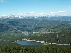
| 5 |
Echo Lake Park |
|
01995-02-24-0000February 24, 1995
(#95000109) |
Along State Highways 5 and 103 southwest of Idaho Springs
39°39′33″N 105°36′03″W / 39.659167°N 105.600833°W / 39.659167; -105.600833 (Echo Lake Park) |
Idaho Springs |
|
| 6 |
Anne Evans Mountain Home |
Upload image |
01992-01-28-0000January 28, 1992
(#91001530) |
Address Restricted
|
Evergreen |
|
| 7 |
Evans-Elbert Ranch |
Upload image |
01980-09-11-0000September 11, 1980
(#80000885) |
Upper Bear Creek Rd.
39°39′10″N 105°28′49″W / 39.652778°N 105.480278°W / 39.652778; -105.480278 (Evans-Elbert Ranch) |
Idaho Springs |
|
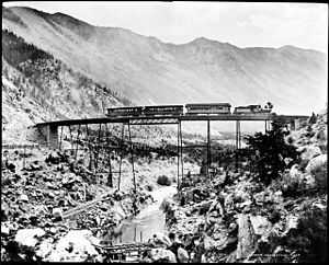
| 8 |
Georgetown Loop Railroad |
|
01970-12-18-0000December 18, 1970
(#70000909) |
Runs between Georgetown and Silver Plume
39°41′56″N 105°42′42″W / 39.698889°N 105.711667°W / 39.698889; -105.711667 (Georgetown Loop Railroad) |
Georgetown and Silver Plume |
|
| 10 |
Georgetown-Silver Plume Historic District |
|
01966-11-13-0000November 13, 1966
(#66000243) |
Interstate 70
39°41′55″N 105°42′48″W / 39.698611°N 105.713333°W / 39.698611; -105.713333 (Georgetown-Silver Plume Historic District) |
Georgetown and Silver Plume |
|
| 11 |
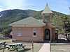
Grace Episcopal Church |
|
01973-08-14-0000August 14, 1973
(#73000465) |
Taos St. between 4th and 5th Sts.
39°42′19″N 105°41′46″W / 39.705278°N 105.696111°W / 39.705278; -105.696111 (Grace Episcopal Church) |
Georgetown |
|
| 12 |
Hamill House |
|
01972-05-31-0000May 31, 1972
(#72000267) |
Argentine and 3rd Sts.
39°42′17″N 105°41′55″W / 39.7047°N 105.6986°W / 39.7047; -105.6986 (Hamill House) |
Georgetown |
|
| 13 |
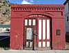
Hose House No. 2 |
|
01998-03-19-0000March 19, 1998
(#98000173) |
600 Colorado Boulevard
39°44′39″N 105°31′33″W / 39.744167°N 105.525833°W / 39.744167; -105.525833 (Hose House No. 2) |
Idaho Springs |
|
| 14 |
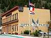
Hotel de Paris |
|
01970-04-28-0000April 28, 1970
(#70000154) |
Alpine St.
39°42′20″N 105°41′27″W / 39.705556°N 105.690833°W / 39.705556; -105.690833 (Hotel de Paris) |
Georgetown |
|
| 15 |
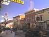
Idaho Springs Downtown Commercial District |
|
01984-01-05-0000January 5, 1984
(#84000801) |
Roughly bounded by Center Alley, 14th Ave., Riverside Dr., and Idaho St.
39°44′32″N 105°30′56″W / 39.742222°N 105.515556°W / 39.742222; -105.515556 (Idaho Springs Downtown Commercial District) |
Idaho Springs |
|
| 16 |
Lebanon and Everett Mine Tunnels |
|
01971-10-07-0000October 7, 1971
(#71000214) |
Northeast of Silver Plume, adjacent to the Interstate 70 right-of-way
39°41′54″N 105°42′47″W / 39.6983°N 105.7131°W / 39.6983; -105.7131 (Lebanon and Everett Mine Tunnels) |
Silver Plume |
|
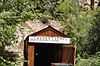
| 17 |
McClellan House |
|
01972-12-05-0000December 5, 1972
(#72000268) |
919 Taos St.
39°41′57″N 105°41′43″W / 39.699167°N 105.695278°W / 39.699167; -105.695278 (McClellan House) |
Georgetown |
|
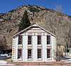
| 18 |
Methodist Episcopal Church |
|
01998-03-05-0000March 5, 1998
(#98000176) |
1440 Colorado Boulevard
39°44′35″N 105°31′00″W / 39.7431°N 105.5167°W / 39.7431; -105.5167 (Methodist Episcopal Church) |
Idaho Springs |
|
| 19 |
Mill City House |
|
02009-04-30-0000April 30, 2009
(#09000250) |
247 County Road 308
39°45′52″N 105°35′59″W / 39.76435°N 105.599614°W / 39.76435; -105.599614 (Mill City House) |
Dumont |
|
| 20 |
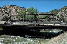
Miner Street Bridge |
|
01985-02-04-0000February 4, 1985
(#85000193) |
Miner St.
39°44′40″N 105°30′45″W / 39.744444°N 105.5125°W / 39.744444; -105.5125 (Miner Street Bridge) |
Idaho Springs |
|
| 21 |
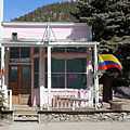
Mint Saloon |
|
01993-02-03-0000February 3, 1993
(#92001845) |
13 E. Park Ave. (U.S. Highway 40)
39°45′40″N 105°40′55″W / 39.761111°N 105.681944°W / 39.761111; -105.681944 (Mint Saloon) |
Empire |
|
| 22 |
Ore Processing Mill and Dam |
Upload image |
01971-05-06-0000May 6, 1971
(#71000213) |
1 mile southwest of Georgetown off Interstate 70
39°41′54″N 105°42′44″W / 39.698333°N 105.712222°W / 39.698333; -105.712222 (Ore Processing Mill and Dam) |
Georgetown |
|
| 23 |
Peck House |
|
01993-03-25-0000March 25, 1993
(#93000201) |
83 Sunny Ave.
39°45′46″N 105°40′59″W / 39.762778°N 105.683056°W / 39.762778; -105.683056 (Peck House) |
Empire |
|
| 24 |
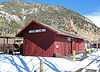
Silver Plume Depot |
|
01971-05-06-0000May 6, 1971
(#71000215) |
Off Interstate 70
39°41′44″N 105°43′24″W / 39.695556°N 105.723333°W / 39.695556; -105.723333 (Silver Plume Depot) |
Silver Plume |
|
| 25 |
Summit Lake Park |
|
01995-02-24-0000February 24, 1995
(#95000110) |
Mt. Evans Rd., southwest of Idaho Springs
39°35′55″N 105°38′40″W / 39.598611°N 105.644444°W / 39.598611; -105.644444 (Summit Lake Park) |
Idaho Springs |
|
| 26 |
Toll House |
|
01970-12-18-0000December 18, 1970
(#70000155) |
Southern side of Georgetown adjacent to Interstate 70
39°42′16″N 105°42′11″W / 39.7044°N 105.7031°W / 39.7044; -105.7031 (Toll House) |
Georgetown |
|
.JPG)