National Register of Historic Places listings in Clay County, Indiana

This is a list of the National Register of Historic Places listings in Clay County, Indiana.
This is intended to be a complete list of the properties and districts on the National Register of Historic Places in Clay County, Indiana, United States. Latitude and longitude coordinates are provided for many National Register properties and districts; these locations may be seen together in a Google map.[1]
There are 14 properties and districts listed on the National Register in the county. Another property was once listed but has been removed.
Properties and districts located in incorporated areas display the name of the municipality, while properties and districts in unincorporated areas display the name of their civil township. Properties and districts split between multiple jurisdictions display the names of all jurisdictions.
- This National Park Service list is complete through NPS recent listings posted May 1, 2015.[2]
Current listings
| [3] | Name on the Register[4] | Image | Date listed[5] | Location | City or town | Description |
|---|---|---|---|---|---|---|
| 1 | Aqueduct Bridge |  |
(#00000209) |
Towpath Rd. over Birch Creek, northwest of Clay City 39°19′36″N 87°10′46″W / 39.326667°N 87.179444°W |
Perry and Sugar Ridge Townships | |
| 2 | Brazil Downtown Historic District | 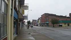 |
(#97000601) |
E. and W. National Ave. between Depot and Forest Aves. 39°31′23″N 87°07′39″W / 39.523056°N 87.1275°W |
Brazil | |
| 3 | Clay County Courthouse |  |
(#99001109) |
Bounded by U.S. Route 40, Harrison, Jackson, and Alabama Sts. 39°31′28″N 87°07′11″W / 39.524444°N 87.119722°W |
Brazil | |
| 4 | Clay County Hospital | 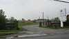 |
(#99001154) |
1200 E. National Ave. 39°31′43″N 87°06′41″W / 39.528611°N 87.111389°W |
Brazil | |
| 5 | Eaglefield Place |  |
(#98001104) |
4870 E. U.S. Route 40, east of Brazil 39°32′50″N 87°00′56″W / 39.547222°N 87.015556°W |
Van Buren Township | |
| 6 | Feeder Dam Bridge | 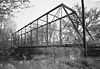 |
(#00000215) |
Towpath Rd. over the Eel River, north of Clay City 39°20′09″N 87°06′49″W / 39.335833°N 87.113611°W |
Harrison and Sugar Ridge Townships | |
| 7 | Indiana State Highway Bridge 42-11-3101 | 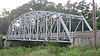 |
(#00000210) |
State Road 42 over the Eel River, west of Poland 39°26′40″N 86°59′37″W / 39.444444°N 86.993611°W |
Cass Township | |
| 8 | Indiana State Highway Bridge 46-11-1316 | 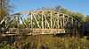 |
(#00000211) |
State Road 46 over the Eel River at Bowling Green 39°23′03″N 87°01′14″W / 39.384167°N 87.020556°W |
Washington Township | |
| 9 | Jeffers Bridge | 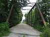 |
(#00000213) |
County Road 200S over Birch Creek, north of Clay City 39°21′31″N 87°08′32″W / 39.358611°N 87.142222°W |
Perry and Sugar Ridge Townships | |
| 10 | Meridian-Forest Historic District | 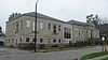 |
(#97000600) |
Roughly bounded by N. Meridian, E. Chestnut, N. Forest, E. and W. Church, and State Sts. 39°31′41″N 87°07′41″W / 39.528056°N 87.128056°W |
Brazil | |
| 11 | Poland Presbyterian Church and Cemetery | 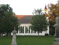 |
(#90001932) |
State Road 42 near County Road 56S at Poland 39°26′41″N 86°57′14″W / 39.444722°N 86.953889°W |
Cass Township | |
| 12 | Shakamak State Park Historic District | 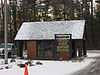 |
(#00000199) |
6265 W. State Road 48, northwest of Jasonville 39°10′35″N 87°14′04″W / 39.176250°N 87.234500°W |
Lewis Township | Extends into Greene and Sullivan counties |
| 13 | Tide Water Pumping Station | 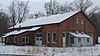 |
(#99001076) |
Southwestern corner of the junction of 900S and 300E, north of Coal City 39°15′16″N 87°03′21″W / 39.254444°N 87.055833°W |
Harrison Township | |
| 14 | US Post Office-Brazil |  |
(#94001132) |
100 E. National Ave. 39°31′26″N 87°07′33″W / 39.523889°N 87.125833°W |
Brazil |
Former listing
| [3] | Name on the Register | Image | Date listed | Date removed | Location | City or town | Summary |
|---|---|---|---|---|---|---|---|
| 1 | Coal Company Store | Upload image | (#86001121) | S. Harmony Rd. |
Harmony |
See also
| Wikimedia Commons has media related to National Register of Historic Places in Clay County, Indiana. |
- List of National Historic Landmarks in Indiana
- National Register of Historic Places listings in Indiana
- List of Indiana state historical markers in Clay County
References
- ↑ The latitude and longitude information provided in this table was derived originally from the National Register Information System, which has been found to be fairly accurate for about 99% of listings. For about 1% of NRIS original coordinates, experience has shown that one or both coordinates are typos or otherwise extremely far off; some corrections may have been made. A more subtle problem causes many locations to be off by up to 150 yards, depending on location in the country: most NRIS coordinates were derived from tracing out latitude and longitudes off of USGS topographical quadrant maps created under the North American Datum of 1927, which differs from the current, highly accurate WGS84 GPS system used by most on-line maps. Chicago is about right, but NRIS longitudes in Washington are higher by about 4.5 seconds, and are lower by about 2.0 seconds in Maine. Latitudes differ by about 1.0 second in Florida. Some locations in this table may have been corrected to current GPS standards.
- ↑ "National Register of Historic Places: Weekly List Actions". National Park Service, United States Department of the Interior. Retrieved on May 1, 2015.
- ↑ 3.0 3.1 Numbers represent an ordering by significant words. Various colorings, defined here, differentiate National Historic Landmarks and historic districts from other NRHP buildings, structures, sites or objects.
- ↑ "National Register Information System". National Register of Historic Places. National Park Service. 2009-03-13.
- ↑ The eight-digit number below each date is the number assigned to each location in the National Register Information System database, which can be viewed by clicking the number.
| ||||||||||||||||||||||||||