National Register of Historic Places listings in Clay County, Arkansas
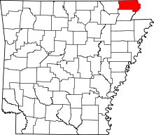
Location of Clay County in Arkansas
This is a list of the National Register of Historic Places listings in Clay County, Arkansas.
This is intended to be a complete list of the properties and districts on the National Register of Historic Places in Clay County, Arkansas, United States. The locations of National Register properties and districts for which the latitude and longitude coordinates are included below, may be seen in a Google map.[1]
There are 18 properties and districts listed on the National Register in the county.
Contents: Counties in Arkansas
|
|
- This National Park Service list is complete through NPS recent listings posted May 1, 2015.[2]
Current listings
| [3] |
Name on the Register[4] |
Image |
Date listed[5] |
Location |
City or town |
Description |
|---|
| 1 |
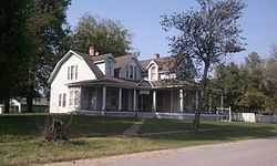
Baynham House |
Upload image |
01978-08-31-0000August 31, 1978
(#78000579) |
Stephens St.
36°27′05″N 90°43′29″W / 36.451389°N 90.724722°W / 36.451389; -90.724722 (Baynham House) |
Success |
|
| 2 |
Chalk Bluff |
Upload image |
01974-10-29-0000October 29, 1974
(#74000470) |
North of St. Francis
36°28′41″N 90°09′32″W / 36.478056°N 90.158889°W / 36.478056; -90.158889 (Chalk Bluff) |
St. Francis |
|
| 3 |
County Home Cemetery |
Upload image |
02005-03-22-0000March 22, 2005
(#04001495) |
3010 Heritage Park Rd.
36°23′11″N 90°12′39″W / 36.386389°N 90.210833°W / 36.386389; -90.210833 (County Home Cemetery) |
Piggott |
|
| 4 |
Eastern Star Lodge 207 F&AM |
Upload image |
02002-10-04-0000October 4, 2002
(#02001074) |
Approximately 1.5 miles west on County Road 336, then 0.5 miles south Cty Rte. 347
36°27′05″N 90°10′31″W / 36.451389°N 90.175278°W / 36.451389; -90.175278 (Eastern Star Lodge 207 F&AM) |
St. Francis |
|
| 5 |
Esso Station |
Upload image |
02000-06-02-0000June 2, 2000
(#00000604) |
287 W. Main
36°22′34″N 90°11′16″W / 36.376111°N 90.187778°W / 36.376111; -90.187778 (Esso Station) |
Piggott |
|
| 6 |
Knob School-Masonic Lodge |
Upload image |
01991-05-30-0000May 30, 1991
(#91000679) |
Highway 141
36°16′53″N 90°27′00″W / 36.281389°N 90.45°W / 36.281389; -90.45 (Knob School-Masonic Lodge) |
Knob |
|
| 7 |
Old US 67, Biggers to Datto |
Upload image |
02004-09-24-0000September 24, 2004
(#04001046) |
Biggers-Reyno Rd., 1st St., and County Road 111
36°21′35″N 90°46′37″W / 36.359722°N 90.776944°W / 36.359722; -90.776944 (Old US 67, Biggers to Datto) |
Datto |
Extends into Randolph County.
|
| 8 |
Oliver House |
|
01978-12-08-0000December 8, 1978
(#78000578) |
203 W. Front St.
36°24′35″N 90°34′44″W / 36.409722°N 90.578889°W / 36.409722; -90.578889 (Oliver House) |
Corning |
|
| 9 |
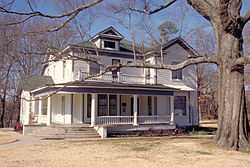
Pfeiffer House and Carriage House |
|
01982-06-10-0000June 10, 1982
(#82002097) |
10th and Cherry Sts.
36°23′04″N 90°12′00″W / 36.384444°N 90.2°W / 36.384444; -90.2 (Pfeiffer House and Carriage House) |
Piggott |
|
| 10 |
Piggott Commercial Historic District |
Upload image |
02009-11-04-0000November 4, 2009
(#09000867) |
Roughly bounded on the north by W. Cherry, on the south by W. Court, on the east by S. Throckmorton, and on the west by Clay
36°22′58″N 90°11′26″W / 36.382839°N 90.190656°W / 36.382839; -90.190656 (Piggott Commercial Historic District) |
Piggott |
|
| 11 |
Piggott National Guard Armory |
Upload image |
02006-05-31-0000May 31, 2006
(#06000440) |
775 E. Main St.
36°22′59″N 90°10′53″W / 36.383056°N 90.181389°W / 36.383056; -90.181389 (Piggott National Guard Armory) |
Piggott |
|
| 12 |
Piggott Post Office |
Upload image |
01998-08-14-0000August 14, 1998
(#98000917) |
119 N. 3rd St.
36°23′00″N 90°11′33″W / 36.383333°N 90.1925°W / 36.383333; -90.1925 (Piggott Post Office) |
Piggott |
|
| 13 |
Rector Commercial Historic District |
Upload image |
02009-06-01-0000June 1, 2009
(#09000369) |
Bounded by the former St. Louis Southwestern Railway railroad tracks on the east and south, S. Dodd on the west, and 3rd St. on the north
36°15′49″N 90°17′34″W / 36.263686°N 90.292717°W / 36.263686; -90.292717 (Rector Commercial Historic District) |
Rector |
|
| 14 |
Rector Waterworks Building |
Upload image |
02009-05-12-0000May 12, 2009
(#09000312) |
703 S. Main St.
36°15′39″N 90°17′34″W / 36.26075°N 90.292722°W / 36.26075; -90.292722 (Rector Waterworks Building) |
Rector |
|
| 15 |
Scatterville Cemetery |
Upload image |
01995-03-31-0000March 31, 1995
(#95000364) |
County Road 404, 1.5 miles west of Highway 90
36°16′55″N 90°18′47″W / 36.281944°N 90.313056°W / 36.281944; -90.313056 (Scatterville Cemetery) |
Rector |
|
| 16 |
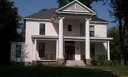
Sheeks House |
|
01975-08-22-0000August 22, 1975
(#75000376) |
502 Market St.
36°24′18″N 90°35′02″W / 36.405°N 90.583889°W / 36.405; -90.583889 (Sheeks House) |
Corning |
|
| 17 |
Sink-Crumb Post No. 72 American Legion Hut |
Upload image |
02008-09-25-0000September 25, 2008
(#08000934) |
Northeastern corner of the junction of 2nd and Cherry Sts.
36°19′13″N 90°36′01″W / 36.320308°N 90.600222°W / 36.320308; -90.600222 (Sink-Crumb Post No. 72 American Legion Hut) |
Knobel |
|
| 18 |
Waddle House |
Upload image |
01977-03-28-0000March 28, 1977
(#77000246) |
S. Erwin
36°27′04″N 90°43′21″W / 36.451111°N 90.7225°W / 36.451111; -90.7225 (Waddle House) |
Success |
|
See also
References
- ↑ The latitude and longitude information provided in this table was derived originally from the National Register Information System, which has been found to be fairly accurate for about 99% of listings. For about 1% of NRIS original coordinates, experience has shown that one or both coordinates are typos or otherwise extremely far off; some corrections may have been made. A more subtle problem causes many locations to be off by up to 150 yards, depending on location in the country: most NRIS coordinates were derived from tracing out latitude and longitudes off of USGS topographical quadrant maps created under the North American Datum of 1927, which differs from the current, highly accurate WGS84 GPS system used by most on-line maps. Chicago is about right, but NRIS longitudes in Washington are higher by about 4.5 seconds, and are lower by about 2.0 seconds in Maine. Latitudes differ by about 1.0 second in Florida. Some locations in this table may have been corrected to current GPS standards.
- ↑ "National Register of Historic Places: Weekly List Actions". National Park Service, United States Department of the Interior. Retrieved on May 1, 2015.
- ↑ Numbers represent an ordering by significant words. Various colorings, defined here, differentiate National Historic Landmarks and historic districts from other NRHP buildings, structures, sites or objects.
- ↑ "National Register Information System". National Register of Historic Places. National Park Service. 2009-03-13.
- ↑ The eight-digit number below each date is the number assigned to each location in the National Register Information System database, which can be viewed by clicking the number.
|
|---|
| | Topics | |
|---|
| | Lists by states | |
|---|
| | Lists by insular areas | |
|---|
| | Lists by associated states | |
|---|
| | Other areas | |
|---|
|
-
 Category Category
-
 Portal Portal
-
 WikiProject WikiProject
|
|