National Register of Historic Places listings in Clallam County, Washington

Location of Clallam County in Washington
This is a list of the National Register of Historic Places listings in Clallam County, Washington.
This is intended to be a complete list of the properties and districts on the National Register of Historic Places in Clallam County, Washington, United States. Latitude and longitude coordinates are provided for many National Register properties and districts; these locations may be seen together in a Google map.[1]
There are 49 properties and districts listed on the National Register in the county.
- This National Park Service list is complete through NPS recent listings posted May 1, 2015.[2]
Current listings
| [3] | Name on the Register[4] | Image | Date listed[5] | Location | City or town | Description |
|---|---|---|---|---|---|---|
| 1 | Aircraft Warning Service Observation Tower | 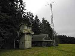 |
(#93000363) |
216 Spring Rd. 48°06′13″N 123°14′59″W / 48.103611°N 123.249722°W |
Agnew | |
| 2 | Altair Campground Community Kitchen | Upload image | (#07000732) |
Approx. 4 mi. S of US 101 48°00′42″N 123°35′30″W / 48.011667°N 123.591667°W |
Port Angeles | |
| 3 | Beaver School | Upload image | (#92001591) |
US 101 N, W side 48°03′50″N 124°18′38″W / 48.063889°N 124.310556°W |
Beaver | Rural Public Schools of Washington State MPS |
| 4 | Blue Mountain School | 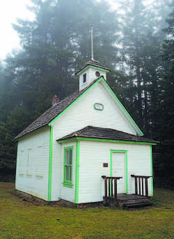 |
(#87001938) |
Blue Mountain Rd. 48°03′02″N 123°16′21″W / 48.050556°N 123.2725°W |
Port Angeles | Rural Public Schools of Washington State MPS |
| 5 | Canyon Creek Shelter | 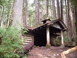 |
(#07000712) |
Approximately .9 miles north of the Upper Sol Duc River Trailhead Coordinates missing |
Port Angeles | |
| 6 | Clallam County Courthouse | 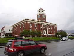 |
(#87001459) |
319 Lincoln St. 48°06′57″N 123°25′55″W / 48.115833°N 123.431944°W |
Port Angeles | |
| 7 | Dodger Point Fire Lookout | 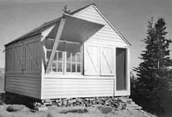 |
(#07000736) |
Approx. 13 mi. along Dodger Point Trail starting at the Whiskey Bend Trail 47°52′29″N 123°30′29″W / 47.874722°N 123.508056°W |
Port Angeles | |
| 8 | Dungeness River Bridge | 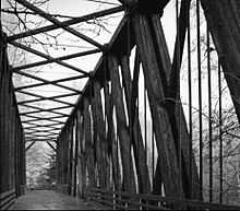 |
(#82004201) |
Spans Dungeness River 48°05′08″N 123°08′46″W / 48.085556°N 123.146111°W |
Sequim | Historic Bridges and Tunnels in Washington TR |
| 9 | Dungeness School | 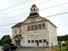 |
(#88000627) |
657 Towne Rd. 48°08′34″N 123°07′38″W / 48.142778°N 123.127222°W |
Dungeness | Rural Public Schools of Washington State MPS |
| 10 | Eagle Ranger Station | Upload image | (#07000713) |
Approximately 11.6 miles south of WA 101 on Upper Sol Duc Rd. 47°58′19″N 123°51′52″W / 47.971944°N 123.864444°W |
Port Angeles | |
| 11 | Elkhorn Guard Station | Upload image | (#07000714) |
Approximately 11.5 miles along Elwha River Trail from the Whiskey Bend Trailhead Coordinates missing |
Port Angeles | |
| 12 | Elwha Campground Community Kitchen | Upload image | (#07000735) |
3 miles south of U.S. Route 101 in Washington 48°01′39″N 123°35′13″W / 48.0275°N 123.586944°W |
Port Angeles | |
| 13 | Elwha Ranger Station | 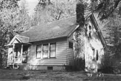 |
(#07000716) |
Approximately 3 miles southeast of WA 101 on the Olympic Hot Springs Rd. 48°01′00″N 123°35′27″W / 48.016667°N 123.590833°W |
Port Angeles | |
| 14 | Elwha River Bridge | 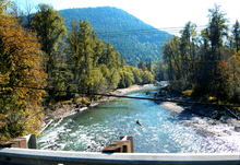 |
(#82004200) |
Old Hwy. 112 48°06′04″N 123°33′23″W / 48.101111°N 123.556389°W |
Elwha | Historic Bridges and Tunnels in Washington TR. Photo shows the view from the replacement bridge. |
| 15 | Elwha River Hydroelectric Power Plant | 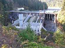 |
(#88002741) |
N end of Lake Aldwell 48°05′42″N 123°33′18″W / 48.095°N 123.555°W |
Port Angeles | |
| 16 | Emery Farmstead | Upload image | (#88002746) |
Emery Rd. 48°04′12″N 123°15′41″W / 48.07°N 123.261389°W |
Port Angeles | |
| 17 | Fifteen Mile Shelter | Upload image | (#07000715) |
Approx. 12.4 mi. from park boundary on N Fork Bogachiel R Trail 47°54′10″N 124°01′14″W / 47.902778°N 124.020556°W |
Port Angeles | |
| 18 | Glines Canyon Hydroelectric Power Plant | 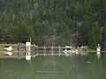 |
(#88002742) |
N end of Lake Mills at Elwha River 48°00′11″N 123°35′54″W / 48.003056°N 123.598333°W |
Port Angeles | |
| 19 | Hoko River Archeological Site |  |
(#78002735) |
Address Restricted |
Pysht | |
| 20 | Hoko River Rockshelter Archeological Site | |
(#80003997) |
Address Restricted |
Sekiu | |
| 21 | Humes Ranch Cabin | 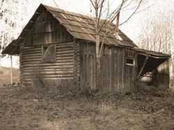 |
(#77001332) |
S of Port Angeles on Elwha River 47°56′53″N 123°32′39″W / 47.948056°N 123.544167°W |
Port Angeles | |
| 22 | Hyak Shelter | Upload image | (#07000721) |
Approx. 15.4 mi. from park boundary on N Fork Bogachiel River Trail 47°55′27″N 123°58′14″W / 47.924167°N 123.970556°W |
Port Angeles | |
| 23 | John A. Hyer Farm | |
(#94000797) |
Address Restricted |
Sequim | |
| 24 | Manis Mastodon Site | |
(#78002736) |
Address Restricted |
Sequim | |
| 25 | Masonic Temple | 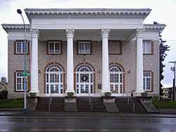 |
(#89000400) |
622 S. Lincoln St. 48°06′48″N 123°26′08″W / 48.113333°N 123.435556°W |
Port Angeles | |
| 26 | McAlmond House | Upload image | (#76001879) |
N of Sequim on Dungeness Bay 48°09′03″N 123°08′05″W / 48.150833°N 123.134722°W |
Sequim | |
| 27 | Michael's Cabin | Upload image | (#07000733) |
Along Elwha River Trail; approx 2 mi. from Whiskey Bend Trailhead 47°57′12″N 123°33′11″W / 47.953333°N 123.553056°W |
Port Angeles | |
| 28 | Naval Lodge Elks Building | 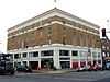 |
(#86000956) |
131 E. First St. 48°07′07″N 123°25′51″W / 48.118611°N 123.430833°W |
Port Angeles | |
| 29 | New Dungeness Light Station | .jpg) |
(#93001338) |
Dungeness Spit 48°10′56″N 123°06′17″W / 48.182222°N 123.104722°W |
Sequim | |
| 30 | North Fork Sol Duc Shelter | Upload image | (#07000725) |
Approx. 9.5 mi. from North Fork Sol Duc Trailhead 47°59′56″N 123°45′42″W / 47.998889°N 123.761667°W |
Port Angeles | |
| 31 | Olympic National Park Headquarters Historic District | 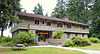 |
(#07000720) |
600 E. Park Ave. 48°06′03″N 123°25′58″W / 48.100833°N 123.432778°W |
Port Angeles | |
| 32 | Ozette Indian Village Archeological Site | 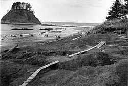 |
(#74000916) |
Address Restricted |
La Push | |
| 33 | Joseph Paris House | 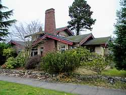 |
(#87001939) |
101 E. Fifth St. 48°06′57″N 123°26′06″W / 48.115833°N 123.435°W |
Port Angeles | |
| 34 | Port Angeles Civic Historic District | 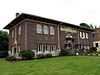 |
(#11000259) |
205, 215, 217 & 319 S. Lincoln St. 48°07′01″N 123°25′58″W / 48.116944°N 123.432778°W |
Port Angeles | Includes former Carnegie Library (1918), City Building (1930) and former Clallam County Courthouse, which is individually listed on the register. |
| 35 | Pyramid Peak Aircraft Warning Service Lookout | 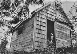 |
(#07000726) |
3.5 miles up Pyramid Pk.trail at end of Camp David Jr. Rd. 48°04′30″N 123°48′44″W / 48.075°N 123.812222°W |
Port Angeles | |
| 36 | Peter Roose Homestead | .JPG) |
(#07000723) |
Along Indian Village Trail; approximately 1.5 miles north of trailhead[6] 48°09′42″N 124°42′24″W / 48.1617°N 124.7067°W |
Port Angeles | |
| 37 | Rosemary Inn | 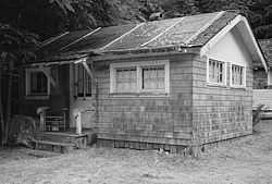 |
(#79001033) |
SW of Port Angeles on Barnes Point 48°03′36″N 123°47′33″W / 48.06°N 123.7925°W |
Port Angeles | |
| 38 | Sekiu School | Upload image | (#91000539) |
Rice St. 48°15′47″N 124°18′02″W / 48.263056°N 124.300556°W |
Sekiu | Rural Public Schools of Washington State MPS |
| 39 | Sequim Opera House | 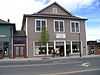 |
(#91000632) |
119 N. Sequim Ave. 48°04′49″N 123°06′04″W / 48.080278°N 123.101111°W |
Sequim | |
| 40 | Singer's Lake Crescent Tavern | 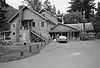 |
(#07000724) |
Barnes Point, south shore of Lake Crescent, WA 101 48°03′25″N 123°48′00″W / 48.056944°N 123.8°W |
Port Angeles | |
| 41 | St. Andrew's Episcopal Church | .jpg) |
(#87001942) |
206 S. Peabody St. 48°06′58″N 123°25′41″W / 48.116111°N 123.428056°W |
Port Angeles | |
| 42 | Storm King Ranger Station | 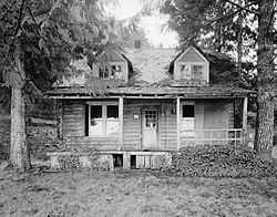 |
(#07000730) |
Barnes Pt., S side of Lake Crescent off US 101 48°03′29″N 123°47′14″W / 48.058056°N 123.787222°W |
Port Angeles | |
| 43 | Tatoosh Island | 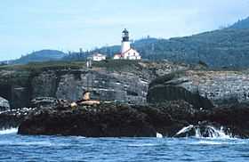 |
(#72001267) |
NW of Cape Flattery 48°23′31″N 124°44′01″W / 48.391944°N 124.733611°W |
Olympic Peninsula | |
| 44 | Three Forks Shelter | Upload image | (#07000728) |
Approx. 4.5 mi. from the Three Fords Trailhead at Deer Park Campground 47°54′56″N 123°14′44″W / 47.915556°N 123.245556°W |
Port Angeles | |
| 45 | Tse whit zen Village | Upload image | (#14000848) |
Address Restricted 48°07′49″N 123°27′42″W / 48.1302°N 123.4618°W |
Port Angeles vicinity | |
| 46 | U.S. Post Office | 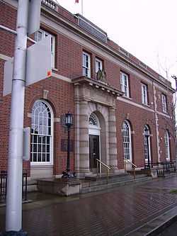 |
(#83003321) |
W. 1st and Oak Sts. 48°07′10″N 123°26′02″W / 48.119444°N 123.433889°W |
Port Angeles | |
| 47 | US Quarantine Station Surgeon's Residence | 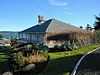 |
(#89000401) |
101 Discovery Way, Diamond Point 48°05′40″N 122°55′10″W / 48.094444°N 122.919444°W |
Sequim | |
| 48 | Wedding Rock Petroglyphs | 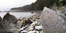 |
(#76000951) |
Address Restricted |
Forks | |
| 49 | Wendel Property | Upload image | (#07000739) |
5 miles north on East Shore Rd. 48°05′42″N 123°47′59″W / 48.095°N 123.799722°W |
Port Angeles |
See also
| Wikimedia Commons has media related to National Register of Historic Places in Clallam County, Washington. |
- National Register of Historic Places listings in Washington state
- List of National Historic Landmarks in Washington
References
- ↑ The latitude and longitude information provided in this table was derived originally from the National Register Information System, which has been found to be fairly accurate for about 99% of listings. For about 1% of NRIS original coordinates, experience has shown that one or both coordinates are typos or otherwise extremely far off; some corrections may have been made. A more subtle problem causes many locations to be off by up to 150 yards, depending on location in the country: most NRIS coordinates were derived from tracing out latitude and longitudes off of USGS topographical quadrant maps created under the North American Datum of 1927, which differs from the current, highly accurate WGS84 GPS system used by most on-line maps. Chicago is about right, but NRIS longitudes in Washington are higher by about 4.5 seconds, and are lower by about 2.0 seconds in Maine. Latitudes differ by about 1.0 second in Florida. Some locations in this table may have been corrected to current GPS standards.
- ↑ "National Register of Historic Places: Weekly List Actions". National Park Service, United States Department of the Interior. Retrieved on May 1, 2015.
- ↑ Numbers represent an ordering by significant words. Various colorings, defined here, differentiate National Historic Landmarks and historic districts from other NRHP buildings, structures, sites or objects.
- ↑ "National Register Information System". National Register of Historic Places. National Park Service. 2008-04-24.
- ↑ The eight-digit number below each date is the number assigned to each location in the National Register Information System database, which can be viewed by clicking the number.
- ↑ Geocode coordinates derived from The Ozette Prairies of Olympic National Park: Their Former Indigenous Uses and Management.
| |||||||||||||||||


| ||||||||||||||||||||||||||
| |||||||||||||||||||||||||