National Register of Historic Places listings in Citrus County, Florida
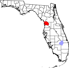
Location of Citrus County in Florida
This is a list of the National Register of Historic Places listings in Citrus County, Florida.
This is intended to be a complete list of the properties and districts on the National Register of Historic Places in Citrus County, Florida, United States. The locations of National Register properties and districts for which the latitude and longitude coordinates are included below, may be seen in a Google map.[1]
There are 10 properties and districts listed on the National Register in the county, including 1 National Historic Landmark.
- This National Park Service list is complete through NPS recent listings posted May 1, 2015.[2]
Current listings
| [3] |
Name on the Register[4] |
Image |
Date listed[5] |
Location |
City or town |
Description |
|---|
| 1 |
Crystal River Indian Mounds |
|
01970-09-29-0000September 29, 1970
(#70000178) |
2 miles northwest of Crystal River on U.S. Routes 19/98
28°55′01″N 82°36′33″W / 28.916944°N 82.609167°W / 28.916944; -82.609167 (Crystal River Indian Mounds) |
Crystal River |
|
| 2 |
Crystal River Old City Hall |
|
01998-05-29-0000May 29, 1998
(#98000588) |
532 North Citrus Avenue
28°53′55″N 82°35′36″W / 28.898611°N 82.593333°W / 28.898611; -82.593333 (Crystal River Old City Hall) |
Crystal River |
|
| 3 |
Etna Turpentine Camp Archeological Site |
|
02009-12-10-0000December 10, 2009
(#09001055) |
Address Restricted
|
Inverness vicinity |
|
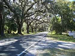
| 4 |
Floral City Historic District |
|
01993-12-01-0000December 1, 1993
(#93001357) |
Roughly Orange Avenue from South Old Floral City Road to South Annie Terrace and South Aroostook Way from Orange to Lake Tsala Apopka
28°45′02″N 82°17′27″W / 28.750556°N 82.290833°W / 28.750556; -82.290833 (Floral City Historic District) |
Floral City |
|
| 5 |
Fort Cooper |
|
01972-06-13-0000June 13, 1972
(#72000304) |
Address Restricted
28°48′36″N 82°18′19″W / 28.81°N 82.305278°W / 28.81; -82.305278 (Fort Cooper) |
Inverness |
|
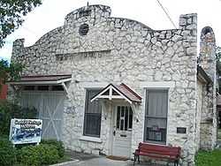
| 6 |
Masonic Temple of Citrus Lodge No. 18, F. and A.M. |
|
02010-06-23-0000June 23, 2010
(#10000387) |
111 West Main St
28°50′09″N 82°19′53″W / 28.835833°N 82.331389°W / 28.835833; -82.331389 (Masonic Temple of Citrus Lodge No. 18, F. and A.M.) |
Inverness |
NRHP No. 10000387
|
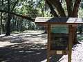
| 7 |
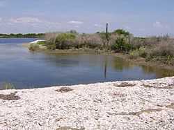
Mullet Key |
|
01986-07-03-0000July 3, 1986
(#86001409) |
In Crystal Bay, within Crystal River Preserve State Park[6]
28°52′52″N 82°41′32″W / 28.8811°N 82.6922°W / 28.8811; -82.6922 (Mullet Key) |
Crystal River |
|
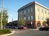
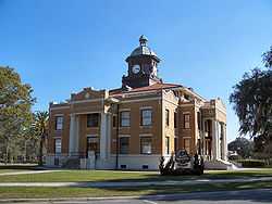
| 8 |
Old Citrus County Courthouse |
|
01992-04-17-0000April 17, 1992
(#92000340) |
1 Courthouse Square
28°50′08″N 82°19′49″W / 28.835556°N 82.330278°W / 28.835556; -82.330278 (Old Citrus County Courthouse) |
Inverness |
|
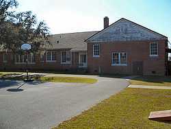
| 9 |
Old Hernando Elementary School |
|
02001-05-04-0000May 4, 2001
(#00001129) |
2435 North Florida Avenue
28°53′53″N 82°22′22″W / 28.898056°N 82.372778°W / 28.898056; -82.372778 (Old Hernando Elementary School) |
Hernando |
|
| 10 |
Yulee Sugar Mill Ruins |
|
01970-08-12-0000August 12, 1970
(#70000179) |
State Road 490 west of U.S. Route 19
28°47′01″N 82°36′28″W / 28.783611°N 82.607778°W / 28.783611; -82.607778 (Yulee Sugar Mill Ruins) |
Homosassa |
|
See also
References
- ↑ The latitude and longitude information provided in this table was derived originally from the National Register Information System, which has been found to be fairly accurate for about 99% of listings. For about 1% of NRIS original coordinates, experience has shown that one or both coordinates are typos or otherwise extremely far off; some corrections may have been made. A more subtle problem causes many locations to be off by up to 150 yards, depending on location in the country: most NRIS coordinates were derived from tracing out latitude and longitudes off of USGS topographical quadrant maps created under the North American Datum of 1927, which differs from the current, highly accurate WGS84 GPS system used by most on-line maps. Chicago is about right, but NRIS longitudes in Washington are higher by about 4.5 seconds, and are lower by about 2.0 seconds in Maine. Latitudes differ by about 1.0 second in Florida. Some locations in this table may have been corrected to current GPS standards.
- ↑ "National Register of Historic Places: Weekly List Actions". National Park Service, United States Department of the Interior. Retrieved on May 1, 2015.
- ↑ Numbers represent an ordering by significant words. Various colorings, defined here, differentiate National Historic Landmarks and historic districts from other NRHP buildings, structures, sites or objects.
- ↑ "National Register Information System". National Register of Historic Places. National Park Service. 2009-03-13.
- ↑ The eight-digit number below each date is the number assigned to each location in the National Register Information System database, which can be viewed by clicking the number.
- ↑ Location derived from its GNIS feature record; the NRIS lists the site as "Address restricted"
|
|---|
| | Lists by county | | |
|---|
| | Lists by city | |
|---|
| | Other lists | |
|---|
| |
|