| [3] |
Name on the Register[4] |
Image |
Date listed[5] |
Location |
City or town |
Description |
|---|
| 1 |
Alston-Bedwell House |
Upload image |
02005-09-08-0000September 8, 2005
(#05001002) |
315 N. State
35°55′00″N 94°58′28″W / 35.916667°N 94.974444°W / 35.916667; -94.974444 (Alston-Bedwell House) |
Tahlequah |
|
| 2 |
American Baptist Home Mission House |
Upload image |
02010-09-03-0000September 3, 2010
(#10000621) |
530 Summit St.
35°55′10″N 94°58′26″W / 35.919444°N 94.973889°W / 35.919444; -94.973889 (American Baptist Home Mission House) |
Tahlequah |
|
| 3 |
American Legion Hut |
Upload image |
02006-08-24-0000August 24, 2006
(#06000798) |
Tehlequah City Park, junction of E. Shawnee St. and N. Brookside Ave.
35°54′47″N 94°58′03″W / 35.913056°N 94.9675°W / 35.913056; -94.9675 (American Legion Hut) |
Tahlequah |
|
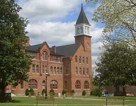
| 4 |
Cherokee Female Seminary |
|
01973-04-05-0000April 5, 1973
(#73001558) |
Northeastern State University campus
35°55′13″N 94°58′12″W / 35.920278°N 94.97°W / 35.920278; -94.97 (Cherokee Female Seminary) |
Tahlequah |
|
| 5 |
Cherokee National Capitol |
|
01966-10-15-0000October 15, 1966
(#66000627) |
Eastern side of Muskogee Ave. between Keetoowah and Delaware Sts.[6]
35°54′45″N 94°58′14″W / 35.9125°N 94.9706°W / 35.9125; -94.9706 (Cherokee National Capitol) |
Tahlequah |
|
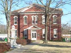
| 6 |
Cherokee National Jail |
|
01974-06-28-0000June 28, 1974
(#74001656) |
Choctaw St. and Water Ave.
35°54′43″N 94°58′02″W / 35.911944°N 94.967222°W / 35.911944; -94.967222 (Cherokee National Jail) |
Tahlequah |
|
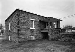
| 7 |
Cherokee Supreme Court Building |
|
01974-06-28-0000June 28, 1974
(#74001657) |
Keetoowah St. and Water Ave.
35°54′47″N 94°58′00″W / 35.913056°N 94.966667°W / 35.913056; -94.966667 (Cherokee Supreme Court Building) |
Tahlequah |
|
| 8 |
First Cherokee Female Seminary Site |
|
01974-04-30-0000April 30, 1974
(#74001658) |
21191 S. Keeler Dr.
35°51′59″N 94°57′11″W / 35.866389°N 94.953056°W / 35.866389; -94.953056 (First Cherokee Female Seminary Site) |
Park Hill |
|
| 9 |
M.E. Franklin House |
Upload image |
02006-09-05-0000September 5, 2006
(#06000791) |
415 N. College Ave.
35°55′03″N 94°58′13″W / 35.9175°N 94.970278°W / 35.9175; -94.970278 (M.E. Franklin House) |
Tahlequah |
|
| 10 |
French-Parks House |
Upload image |
01985-03-18-0000March 18, 1985
(#85000618) |
209 W. Keetoowah St.
35°54′45″N 94°58′23″W / 35.9125°N 94.973056°W / 35.9125; -94.973056 (French-Parks House) |
Tahlequah |
|
| 11 |
Illinois Campground |
Upload image |
02004-12-06-0000December 6, 2004
(#04001330) |
County Road DO775
35°53′42″N 94°57′38″W / 35.895°N 94.960556°W / 35.895; -94.960556 (Illinois Campground) |
Tahlequah |
|
| 12 |
Indian University of Tahlequah |
Upload image |
01976-07-06-0000July 6, 1976
(#76001557) |
320 Academy
35°55′05″N 94°58′20″W / 35.918056°N 94.972222°W / 35.918056; -94.972222 (Indian University of Tahlequah) |
Tahlequah |
|
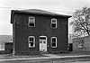
| 13 |
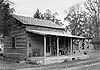
Dr. Irwin D. Loeser Log Cabin |
|
01978-11-17-0000November 17, 1978
(#78002221) |
121 E. Smith St.
35°55′05″N 94°58′02″W / 35.918056°N 94.967222°W / 35.918056; -94.967222 (Dr. Irwin D. Loeser Log Cabin) |
Tahlequah |
|
| 14 |
Leonard M. Logan House |
Upload image |
02005-10-12-0000October 12, 2005
(#05001165) |
531 Summit
35°55′08″N 94°58′26″W / 35.918889°N 94.973889°W / 35.918889; -94.973889 (Leonard M. Logan House) |
Tahlequah |
|
| 15 |
Murrell Home |
|
01970-06-22-0000June 22, 1970
(#70000530) |
19479 East Murrel Road
35°50′57″N 94°57′51″W / 35.849167°N 94.964167°W / 35.849167; -94.964167 (Murrell Home) |
Park Hill |
|
| 16 |
Park Hill Mission Cemetery |
Upload image |
02006-12-06-0000December 6, 2006
(#06001113) |
South Park Hill Rd., 0.5 miles south of East Murrell Rd.
35°50′58″N 94°57′57″W / 35.849444°N 94.965833°W / 35.849444; -94.965833 (Park Hill Mission Cemetery) |
Park Hill |
|
| 17 |
Rosamund |
Upload image |
02006-09-06-0000September 6, 2006
(#06000793) |
527 Seminary Ave.
35°55′05″N 94°58′14″W / 35.918056°N 94.970556°W / 35.918056; -94.970556 (Rosamund) |
Tahlequah |
|
| 18 |
Ross Cemetery |
Upload image |
02002-03-07-0000March 7, 2002
(#02000170) |
0.5 miles south of the junction of Murrell Rd. and N4530 Rd.
35°51′03″N 94°56′53″W / 35.850833°N 94.948056°W / 35.850833; -94.948056 (Ross Cemetery) |
Park Hill |
|
| 19 |
Tahlequah Armory |
Upload image |
01994-05-20-0000May 20, 1994
(#94000488) |
100 Water Ave.
35°54′47″N 94°58′08″W / 35.913056°N 94.968889°W / 35.913056; -94.968889 (Tahlequah Armory) |
Tahlequah |
|
| 20 |
Tahlequah Carnegie Library |
Upload image |
02003-06-05-0000June 5, 2003
(#03000516) |
120 S. College
35°54′48″N 94°58′22″W / 35.913333°N 94.972778°W / 35.913333; -94.972778 (Tahlequah Carnegie Library) |
Tahlequah |
|
| 21 |
Joseph M. Thompson House |
Upload image |
01993-03-11-0000March 11, 1993
(#93000155) |
300 S. College Ave.
35°54′48″N 94°58′33″W / 35.913333°N 94.975833°W / 35.913333; -94.975833 (Joseph M. Thompson House) |
Tahlequah |
|

.jpg)