National Register of Historic Places listings in Charlotte County, Florida

Location of Charlotte County in Florida
This is a list of the National Register of Historic Places listings in Charlotte County, Florida.
This is intended to be a complete list of the properties and districts on the National Register of Historic Places in Charlotte County, Florida, United States. The locations of National Register properties and districts for which the latitude and longitude coordinates are included below, may be seen in a Google map.[1]
There are 17 properties and districts listed on the National Register in the county.
- This National Park Service list is complete through NPS recent listings posted May 1, 2015.[2]
Current listings
| [3] |
Name on the Register[4] |
Image |
Date listed[5] |
Location |
City or town |
Description |
|---|
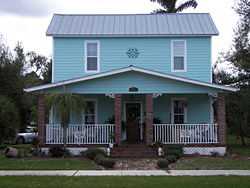
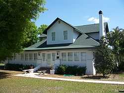
| 1 |
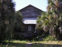
Clarence L. Babcock House |
|
02009-02-25-0000February 25, 2009
(#09000053) |
25537 Shore Drive
26°56′56″N 82°01′35″W / 26.948814°N 82.026356°W / 26.948814; -82.026356 (Clarence L. Babcock House) |
Punta Gorda |
|
| 2 |
Big Mound Key-Boggess Ridge Archeological District |
|
01990-12-03-0000December 3, 1990
(#90001764) |
Address Restricted
|
Placida |
|
| 3 |
Charlotte High School |
|
01990-12-12-0000December 12, 1990
(#90001796) |
1250 Cooper Street
26°55′36″N 82°02′21″W / 26.926667°N 82.039167°W / 26.926667; -82.039167 (Charlotte High School) |
Punta Gorda |
Part of the Punta Gorda MPS
|
| 4 |
El Jobean Hotel |
|
01999-09-29-0000September 29, 1999
(#99001203) |
4381 Garden Road
26°57′50″N 82°12′46″W / 26.963889°N 82.212778°W / 26.963889; -82.212778 (El Jobean Hotel) |
El Jobean |
|
| 5 |
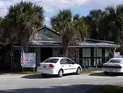
El Jobean Post Office and General Store |
|
01999-08-27-0000August 27, 1999
(#99001028) |
4370 Garden Road
26°57′51″N 82°12′43″W / 26.964167°N 82.211944°W / 26.964167; -82.211944 (El Jobean Post Office and General Store) |
El Jobean |
|
| 6 |
A. C. Freeman House |
|
01987-01-07-0000January 7, 1987
(#86003648) |
639 East Hargreaves Avenue
26°56′18″N 82°02′27″W / 26.938333°N 82.040833°W / 26.938333; -82.040833 (A. C. Freeman House) |
Punta Gorda |
|
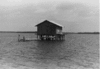
| 7 |
Icing Station at Bull Bay |
Upload image |
01991-04-11-0000April 11, 1991
(#91000399) |
Off Bull Key in Bull Bay
26°46′20″N 82°12′18″W / 26.772222°N 82.205°W / 26.772222; -82.205 (Icing Station at Bull Bay) |
Placida |
Part of the Fish Cabins of Charlotte Harbor MPS
|
| 8 |
Mott Willis Store |
|
01997-05-30-0000May 30, 1997
(#97000434) |
22960 Bayshore Road
26°57′29″N 82°04′31″W / 26.958056°N 82.075278°W / 26.958056; -82.075278 (Mott Willis Store) |
Charlotte Harbor |
Demolished in 1998[6]
|
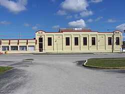
| 9 |
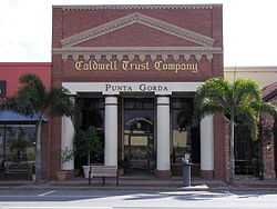
Old First National Bank of Punta Gorda |
|
01991-03-14-0000March 14, 1991
(#91000280) |
133 West Marion Avenue
26°56′06″N 82°03′02″W / 26.935°N 82.050556°W / 26.935; -82.050556 (Old First National Bank of Punta Gorda) |
Punta Gorda |
Part of the Punta Gorda MPS
|
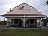
| 10 |
Punta Gorda Atlantic Coast Line Depot |
|
01990-12-12-0000December 12, 1990
(#90001797) |
1009 Taylor Road
26°55′44″N 82°02′46″W / 26.928889°N 82.046111°W / 26.928889; -82.046111 (Punta Gorda Atlantic Coast Line Depot) |
Punta Gorda |
Part of the Punta Gorda MPS
|
| 11 |
Punta Gorda Ice Plant |
|
01990-12-12-0000December 12, 1990
(#90001798) |
408 Tamiami Trail
26°55′57″N 82°02′50″W / 26.9325°N 82.047222°W / 26.9325; -82.047222 (Punta Gorda Ice Plant) |
Punta Gorda |
Part of the Punta Gorda MPS
|
| 12 |
Punta Gorda Residential District |
|
01991-01-07-0000January 7, 1991
(#90002103) |
Roughly bounded by West Retta Esplanade, Berry Street, West Virginia Avenue and Taylor Street
26°55′53″N 82°03′12″W / 26.93145°N 82.053333°W / 26.93145; -82.053333 (Punta Gorda Residential District) |
Punta Gorda |
Part of the Punta Gorda MPS
|
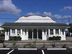
| 13 |
Punta Gorda Woman's Club |
|
01991-04-05-0000April 5, 1991
(#91000382) |
118 Sullivan Street
26°56′06″N 82°03′08″W / 26.935°N 82.052222°W / 26.935; -82.052222 (Punta Gorda Woman's Club) |
Punta Gorda |
Part of the Punta Gorda MPS
|
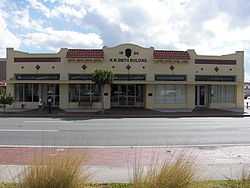
| 14 |
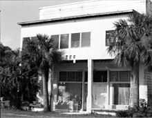
H. W. Smith Building |
|
01991-07-25-0000July 25, 1991
(#91000894) |
121 East Marion Avenue
26°56′09″N 82°02′57″W / 26.935833°N 82.049167°W / 26.935833; -82.049167 (H. W. Smith Building) |
Punta Gorda |
Part of the Punta Gorda MPS
|
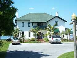
| 15 |
Villa Bianca |
|
01990-11-28-0000November 28, 1990
(#90001760) |
2330 Shore Drive
26°57′01″N 82°01′24″W / 26.950278°N 82.023333°W / 26.950278; -82.023333 (Villa Bianca) |
Punta Gorda |
|
| 16 |
West Coast Fish Company Residential Cabin at Bull Bay |
Upload image |
01991-04-11-0000April 11, 1991
(#91000401) |
Bull Bay north of Bull Key
26°46′33″N 82°12′14″W / 26.775833°N 82.203889°W / 26.775833; -82.203889 (West Coast Fish Company Residential Cabin at Bull Bay) |
Placida |
Part of the Fish Cabins of Charlotte Harbor MPS
|
| 17 |
Willis Fish Cabin at Bull Bay |
|
01991-04-11-0000April 11, 1991
(#91000400) |
Bull Bay north of Bull Key
26°46′28″N 82°12′29″W / 26.774444°N 82.208056°W / 26.774444; -82.208056 (Willis Fish Cabin at Bull Bay) |
Placida |
Part of the Fish Cabins of Charlotte Harbor MPS |
See also
References
- ↑ The latitude and longitude information provided in this table was derived originally from the National Register Information System, which has been found to be fairly accurate for about 99% of listings. For about 1% of NRIS original coordinates, experience has shown that one or both coordinates are typos or otherwise extremely far off; some corrections may have been made. A more subtle problem causes many locations to be off by up to 150 yards, depending on location in the country: most NRIS coordinates were derived from tracing out latitude and longitudes off of USGS topographical quadrant maps created under the North American Datum of 1927, which differs from the current, highly accurate WGS84 GPS system used by most on-line maps. Chicago is about right, but NRIS longitudes in Washington are higher by about 4.5 seconds, and are lower by about 2.0 seconds in Maine. Latitudes differ by about 1.0 second in Florida. Some locations in this table may have been corrected to current GPS standards.
- ↑ "National Register of Historic Places: Weekly List Actions". National Park Service, United States Department of the Interior. Retrieved on May 1, 2015.
- ↑ Numbers represent an ordering by significant words. Various colorings, defined here, differentiate National Historic Landmarks and historic districts from other NRHP buildings, structures, sites or objects.
- ↑ "National Register Information System". National Register of Historic Places. National Park Service. 2009-03-13.
- ↑ The eight-digit number below each date is the number assigned to each location in the National Register Information System database, which can be viewed by clicking the number.
- ↑ Charlotte County History Collections
|
|---|
| | Lists by county | | |
|---|
| | Lists by city | |
|---|
| | Other lists | |
|---|
| |
|

.JPG)