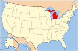
National Register of Historic Places listings in Charlevoix County, Michigan
The following is a list of Registered Historic Places in Charlevoix County, Michigan.
- This National Park Service list is complete through NPS recent listings posted May 1, 2015.[1]
| [2] | Name on the Register[3] | Image | Date listed[4] | Location | City or town | Description |
|---|---|---|---|---|---|---|
| 1 | Beaver Island Light Station | 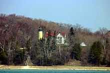 |
(#78001495) |
S of St. James on Beaver Island 45°34′35″N 85°34′21″W / 45.576389°N 85.5725°W |
St. James | |
| 2 | Boyne City Central Historic District | Upload image | (#12001071) |
Water, Pearl, Lake, Ray & Main Sts. 45°12′46″N 85°00′48″W / 45.21278°N 85.0133°W |
Boyne City | |
| 3 | Boyne City Water Works Building | Upload image | (#98001060) |
210 E. Division St. 45°12′17″N 85°00′49″W / 45.204722°N 85.013611°W |
Boyne City | |
| 4 | Charlevoix City Park Site |  |
(#72000602) |
Address Restricted |
Charlevoix | |
| 5 | Charlevoix South Pierhead Light | 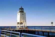 |
(#05000346) |
S pier at harbor entrance, 0.3 WNW of US 31 drawbridge 45°19′13″N 85°15′54″W / 45.320278°N 85.265°W |
Charlevoix | |
| 6 | Chicago and West Michigan Railroad Charlevoix Station | 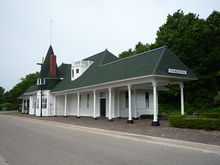 |
(#95001393) |
Chicago Ave. 45°19′03″N 85°14′35″W / 45.3175°N 85.243056°W |
Charlevoix | |
| 7 | East Jordan Lumber Company Store Building | Upload image | (#08000586) |
104 Main St. 45°09′15″N 85°07′39″W / 45.154246°N 85.127563°W |
East Jordan | |
| 8 | Garden Island Indian Cemetery | |
(#78001494) |
Address Restricted |
Charlevoix | |
| 9 | Greensky Hill Mission | Upload image | (#72000603) |
E of Charlevoix at jct. of US 31 and CR 630 45°19′42″N 85°11′05″W / 45.328333°N 85.184722°W |
Charlevoix | |
| 10 | Horton Bay General Store | Upload image | (#91001411) |
05115 Boyne City Rd., Bay Township 45°17′06″N 85°04′48″W / 45.285°N 85.08°W |
Horton Bay | |
| 11 | Horton Bay House-Red Fox Inn | Upload image | (#95000372) |
05156 Boyne City Rd., Bay Township 45°17′06″N 85°04′45″W / 45.285°N 85.079167°W |
Horton Bay | |
| 12 | Horton Bay School | Upload image | (#00001603) |
04991 Boyne City-Charlevoix Rd. 45°17′18″N 85°04′44″W / 45.288333°N 85.078889°W |
Bay Township | |
| 13 | Loeb Farms Barn Complex | Upload image | (#95001392) |
05052 M-66 Hwy. N., SE of Charlevoix, Marion Township 45°16′43″N 85°13′46″W / 45.278611°N 85.229444°W |
Charlevoix | |
| 14 | Mormon Print Shop | 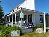 |
(#71000386) |
Main and Forest Sts. 45°44′46″N 85°31′16″W / 45.746111°N 85.521111°W |
St. James | |
| 15 | Mt. McSauba Site | |
(#76001025) |
Address Restricted |
Charlevoix | |
| 16 | O'Neill Site | |
(#71001019) |
Address Restricted |
Charlevoix | |
| 17 | Pewangoing Quarry | |
(#72001471) |
Address Restricted |
Norwood Township | |
| 18 | Pi-wan-go-ning Prehistoric District | |
(#73002153) |
Address Restricted |
Norwood | |
| 19 | Pine River Site | |
(#72001472) |
Address Restricted |
Charlevoix | |
| 20 | John J. and Eva Reynier Porter Estate | Upload image | (#98000269) |
01787 M-66 S 45°10′44″N 85°09′45″W / 45.178889°N 85.1625°W |
South Arm Township | |
| 21 | Feodar Protar Cabin | 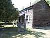 |
(#72000604) |
SW of St. James, on Beaver Island 45°42′13″N 85°33′48″W / 45.703611°N 85.563333°W |
St. James | |
| 22 | Votruba Block | Upload image | (#08000585) |
112 Main St. 45°09′16″N 85°07′39″W / 45.154352°N 85.127521°W |
East Jordan | |
| 23 | Wolverine Hotel | Upload image | (#86000261) |
300 Water St. 45°12′54″N 85°00′58″W / 45.215°N 85.016111°W |
Boyne City | |
| 24 | Wood Site | |
(#76001026) |
Address Restricted |
Charlevoix |
See also
| Wikimedia Commons has media related to National Register of Historic Places in Charlevoix County, Michigan. |
- List of Registered Historic Places in Michigan
References
- ↑ "National Register of Historic Places: Weekly List Actions". National Park Service, United States Department of the Interior. Retrieved on May 1, 2015.
- ↑ Numbers represent an ordering by significant words. Various colorings, defined here, differentiate National Historic Landmarks and historic districts from other NRHP buildings, structures, sites or objects.
- ↑ "National Register Information System". National Register of Historic Places. National Park Service. 2008-04-24.
- ↑ The eight-digit number below each date is the number assigned to each location in the National Register Information System database, which can be viewed by clicking the number.
| ||||||||||||

| ||||||||||||||||||||||||||