National Register of Historic Places listings in Charles Mix County, South Dakota

Location of Charles Mix County in South Dakota
This is a list of the National Register of Historic Places listings in Charles Mix County, South Dakota.
This is intended to be a complete list of the properties and districts on the National Register of Historic Places in Charles Mix County, South Dakota, United States. The locations of National Register properties and districts for which the latitude and longitude coordinates are included below, may be seen in a Google map.[1]
There are 13 properties and districts listed on the National Register in the county. Another property was once listed but has been removed.
- This National Park Service list is complete through NPS recent listings posted May 1, 2015.[2]
Current listings
| [3] |
Name on the Register[4] |
Image |
Date listed[5] |
Location |
City or town |
Description |
|---|
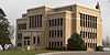
| 1 |
Charles Mix County Courthouse |
|
01993-02-10-0000February 10, 1993
(#92001856) |
Main St. between 4th and 5th Sts.
43°09′20″N 98°32′16″W / 43.155556°N 98.537778°W / 43.155556; -98.537778 (Charles Mix County Courthouse) |
Lake Andes |
|
| 2 |
Church of Christ in LaRoche Township |
Upload image |
01982-07-01-0000July 1, 1982
(#82003920) |
Highway 50
43°27′21″N 99°04′55″W / 43.455833°N 99.081944°W / 43.455833; -99.081944 (Church of Christ in LaRoche Township) |
Academy |
|
| 3 |
Engel Hotel |
Upload image |
02012-02-21-0000February 21, 2012
(#12000035) |
202 Main St.
43°09′22″N 98°32′34″W / 43.156107°N 98.542644°W / 43.156107; -98.542644 (Engel Hotel) |
Lake Andes |
|
| 4 |
Farmers State Bank of Platte |
Upload image |
01983-01-27-0000January 27, 1983
(#83003004) |
404 N. Main St.
43°23′13″N 98°50′40″W / 43.386944°N 98.844444°W / 43.386944; -98.844444 (Farmers State Bank of Platte) |
Platte |
|
| 5 |
Geddes Historic District |
Upload image |
01973-05-08-0000May 8, 1973
(#73001737) |
Off Highway 50
43°15′15″N 98°41′43″W / 43.254167°N 98.695278°W / 43.254167; -98.695278 (Geddes Historic District) |
Geddes |
|
| 6 |
Henry Cool Park |
Upload image |
02011-03-15-0000March 15, 2011
(#11000083) |
0.5 miles (0.80 km) north of the intersection of Highway 50 and 365th Ave
43°23′16″N 98°53′35″W / 43.387778°N 98.893056°W / 43.387778; -98.893056 (Henry Cool Park) |
Platte |
|
| 7 |
Holy Fellowship Episcopal Church |
Upload image |
01975-06-05-0000June 5, 1975
(#75001712) |
Southeast of Greenwood
42°55′23″N 98°23′10″W / 42.923056°N 98.386111°W / 42.923056; -98.386111 (Holy Fellowship Episcopal Church) |
Greenwood |
|
| 8 |
Jacobson School |
Upload image |
02003-02-05-0000February 5, 2003
(#02001762) |
289th St.
43°11′54″N 98°19′38″W / 43.198333°N 98.327222°W / 43.198333; -98.327222 (Jacobson School) |
Armour |
|
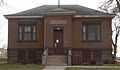
| 9 |
Lake Andes Carnegie Library |
|
02000-06-02-0000June 2, 2000
(#00000598) |
500 Main St.
43°09′21″N 98°32′18″W / 43.155833°N 98.538333°W / 43.155833; -98.538333 (Lake Andes Carnegie Library) |
Lake Andes |
|
| 10 |
Marty Mission School Gymnasium and St. Therese Hall |
Upload image |
02012-01-04-0000January 4, 2012
(#11001012) |
Southwest corner of 303rd St. & 388th Ave.
42°59′34″N 98°25′31″W / 42.992831°N 98.425397°W / 42.992831; -98.425397 (Marty Mission School Gymnasium and St. Therese Hall) |
Marty |
part of Schools in South Dakota MPS
|
| 11 |
Pratt & Cjolme Building |
Upload image |
02007-06-08-0000June 8, 2007
(#07000532) |
500 S. Main
43°23′17″N 98°50′42″W / 43.388056°N 98.845°W / 43.388056; -98.845 (Pratt & Cjolme Building) |
Platte |
|
| 12 |
Rising Hail Colony |
Upload image |
01975-04-28-0000April 28, 1975
(#75001713) |
5 miles (8.0 km) northwest of Greenwood along Seven Mile Creek
43°00′13″N 98°28′58″W / 43.003611°N 98.482778°W / 43.003611; -98.482778 (Rising Hail Colony) |
Greenwood |
|
| 13 |
Wagner House |
Upload image |
02007-11-19-0000November 19, 2007
(#07001209) |
29649 401st. Ave.
43°05′31″N 98°10′31″W / 43.091944°N 98.175278°W / 43.091944; -98.175278 (Wagner House) |
Wagner |
|
Former listing
| [3] |
Name on the Register |
Image |
Date listed | Date removed |
Location |
City or town |
Summary |
|---|
| 1 |
South Dakota Dept. of Transportation Bridge No. 12-503-230 |
Upload image |
01993-12-09-0000December 9, 1993
(#93001278) | 01999-12-15-0000December 15, 1999 |
Local road over Choteau Creek
|
Wagner |
|
See also
References
- ↑ The latitude and longitude information provided in this table was derived originally from the National Register Information System, which has been found to be fairly accurate for about 99% of listings. For about 1% of NRIS original coordinates, experience has shown that one or both coordinates are typos or otherwise extremely far off; some corrections may have been made. A more subtle problem causes many locations to be off by up to 150 yards, depending on location in the country: most NRIS coordinates were derived from tracing out latitude and longitudes off of USGS topographical quadrant maps created under the North American Datum of 1927, which differs from the current, highly accurate WGS84 GPS system used by most on-line maps. Chicago is about right, but NRIS longitudes in Washington are higher by about 4.5 seconds, and are lower by about 2.0 seconds in Maine. Latitudes differ by about 1.0 second in Florida. Some locations in this table may have been corrected to current GPS standards.
- ↑ "National Register of Historic Places: Weekly List Actions". National Park Service, United States Department of the Interior. Retrieved on May 1, 2015.
- ↑ 3.0 3.1 Numbers represent an ordering by significant words. Various colorings, defined here, differentiate National Historic Landmarks and historic districts from other NRHP buildings, structures, sites or objects.
- ↑ "National Register Information System". National Register of Historic Places. National Park Service. 2008-04-24.
- ↑ The eight-digit number below each date is the number assigned to each location in the National Register Information System database, which can be viewed by clicking the number.
|
|---|
| | Topics | |
|---|
| | Lists by states | |
|---|
| | Lists by insular areas | |
|---|
| | Lists by associated states | |
|---|
| | Other areas | |
|---|
|
-
 Category Category
-
 Portal Portal
-
 WikiProject WikiProject
|
|