| [3] |
Name on the Register[4] |
Image |
Date listed[5] |
Location |
City or town |
Description |
|---|
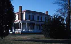
| 1 |
Brown-Graves House and Brown's Store |
Upload image |
01974-07-15-0000July 15, 1974
(#74001334) |
SW of Yanceyville on NC 150
36°21′36″N 79°27′04″W / 36.359872°N 79.451194°W / 36.359872; -79.451194 (Brown-Graves House and Brown's Store) |
Locust Hill |
|
| 2 |
Caswell County Courthouse |
|
01973-06-04-0000June 4, 1973
(#73001309) |
Courthouse Sq.
36°24′11″N 79°20′11″W / 36.402978°N 79.336333°W / 36.402978; -79.336333 (Caswell County Courthouse) |
Yanceyville |
|
| 3 |
Garland-Buford House |
Upload image |
01974-01-24-0000January 24, 1974
(#74001333) |
N of Leasburg on SR 1561
36°27′27″N 79°08′57″W / 36.457489°N 79.149039°W / 36.457489; -79.149039 (Garland-Buford House) |
Leasburg |
|
| 4 |
Graves House |
Upload image |
01974-11-20-0000November 20, 1974
(#74001335) |
U.S. 158 at NC 86
36°24′15″N 79°19′20″W / 36.404186°N 79.322264°W / 36.404186; -79.322264 (Graves House) |
Yanceyville |
|
| 5 |
Griers Presbyterian Church and Cemetery |
Upload image |
01985-12-30-0000December 30, 1985
(#85003187) |
SR 1710
36°20′50″N 79°13′10″W / 36.347222°N 79.219444°W / 36.347222; -79.219444 (Griers Presbyterian Church and Cemetery) |
Frogsboro |
|
| 6 |
William Henry and Sarah Holderness House |
Upload image |
02014-12-02-0000December 2, 2014
(#14000982) |
3082 US 158 W.
36°23′44″N 79°23′16″W / 36.3955°N 79.3877°W / 36.3955; -79.3877 (William Henry and Sarah Holderness House) |
Yanceyville vicinity |
|
| 7 |
John Johnston House |
Upload image |
01997-03-14-0000March 14, 1997
(#97000238) |
1325 NC 62, N.
36°26′08″N 79°16′59″W / 36.435556°N 79.283056°W / 36.435556; -79.283056 (John Johnston House) |
Yanceyville |
|
| 8 |
Longwood |
Upload image |
01976-09-15-0000September 15, 1976
(#76001312) |
SW of Milton on NC 62
36°31′40″N 79°13′10″W / 36.527778°N 79.219444°W / 36.527778; -79.219444 (Longwood) |
Milton |
|
| 9 |
James Malone House |
Upload image |
02008-04-30-0000April 30, 2008
(#08000367) |
7374 US 158
36°23′39″N 79°09′27″W / 36.394056°N 79.1576°W / 36.394056; -79.1576 (James Malone House) |
Leasburg |
|
| 10 |
Melrose/Williamson House |
|
01985-02-28-0000February 28, 1985
(#85000379) |
Off NC 62
36°25′42″N 79°17′51″W / 36.428333°N 79.2975°W / 36.428333; -79.2975 (Melrose/Williamson House) |
Yanceyville Township |
|
| 11 |
Milton Historic District |
Upload image |
01973-10-25-0000October 25, 1973
(#73001306) |
Runs along Main St. from Atlantic and Danville RR to County Line Creek
36°32′15″N 79°12′25″W / 36.5375°N 79.206944°W / 36.5375; -79.206944 (Milton Historic District) |
Milton |
|
| 12 |
Milton State Bank |
Upload image |
01973-04-13-0000April 13, 1973
(#73001307) |
Main (Broad) St.
36°32′19″N 79°12′17″W / 36.538611°N 79.204722°W / 36.538611; -79.204722 (Milton State Bank) |
Milton |
|
| 13 |
Moore House |
Upload image |
01973-08-28-0000August 28, 1973
(#73001304) |
E of Locust Hill off U.S. 158
36°22′12″N 79°25′44″W / 36.369986°N 79.428778°W / 36.369986; -79.428778 (Moore House) |
Locust Hill |
|
| 14 |
Poteat House |
|
01979-10-24-0000October 24, 1979
(#79001688) |
N of Yanceyville on NC 62
36°25′11″N 79°18′37″W / 36.419722°N 79.310278°W / 36.419722; -79.310278 (Poteat House) |
Yanceyville |
|
| 15 |
Red House Presbyterian Church |
Upload image |
02007-05-01-0000May 1, 2007
(#07000413) |
13409 NC 119 N
36°29′14″N 79°09′46″W / 36.487222°N 79.162778°W / 36.487222; -79.162778 (Red House Presbyterian Church) |
Semora |
|
| 16 |
Rose Hill |
|
01973-10-25-0000October 25, 1973
(#73001305) |
On U.S. 158 at jct. with NC 150
36°22′22″N 79°25′59″W / 36.372778°N 79.433153°W / 36.372778; -79.433153 (Rose Hill) |
Locust Hill |
|
| 17 |
Union Tavern |
|
01975-05-15-0000May 15, 1975
(#75001245) |
Main St.
36°32′18″N 79°12′24″W / 36.538333°N 79.206667°W / 36.538333; -79.206667 (Union Tavern) |
Milton |
|
| 18 |
Warren House and Warren's Store |
Upload image |
01973-06-19-0000June 19, 1973
(#73001308) |
On NC 86
36°14′56″N 79°11′24″W / 36.248889°N 79.19°W / 36.248889; -79.19 (Warren House and Warren's Store) |
Prospect Hill |
|
| 19 |
Wildwood |
Upload image |
02001-10-05-0000October 5, 2001
(#01001076) |
5680 Stephenton Rd.
36°27′20″N 79°11′47″W / 36.455556°N 79.196389°W / 36.455556; -79.196389 (Wildwood) |
Semora |
|
| 20 |
Woodside |
Upload image |
01986-03-06-0000March 6, 1986
(#86000420) |
NC 57
36°31′32″N 79°11′02″W / 36.525556°N 79.183889°W / 36.525556; -79.183889 (Woodside) |
Milton |
|
| 21 |
Bartlett Yancey House |
|
01973-12-04-0000December 4, 1973
(#73001310) |
Address Restricted
|
Yanceyville |
|
| 22 |
Yanceyville Historic District |
Upload image |
01973-10-15-0000October 15, 1973
(#73001311) |
W. Main St., Courthouse Sq., and North Ave. to Church St.
36°24′19″N 79°20′27″W / 36.405278°N 79.340833°W / 36.405278; -79.340833 (Yanceyville Historic District) |
Yanceyville |
|


.jpg)
.jpg)

.jpg)