National Register of Historic Places listings in Carter County, Oklahoma

Location of Carter County in Oklahoma
This is a list of the National Register of Historic Places listings in Carter County, Oklahoma.
This is intended to be a complete list of the properties and districts on the National Register of Historic Places in Carter County, Oklahoma, United States. The locations of National Register properties and districts for which the latitude and longitude coordinates are included below, may be seen in a Google map.[1]
There are 22 properties and districts listed on the National Register in the county.
- This National Park Service list is complete through NPS recent listings posted May 1, 2015.[2]
| Adair - Alfalfa - Atoka - Beaver - Beckham - Blaine - Bryan - Caddo - Canadian - Carter - Cherokee - Choctaw - Cimarron - Cleveland - Coal - Comanche - Cotton - Craig - Creek - Custer - Delaware - Dewey - Ellis - Garfield - Garvin - Grady - Grant - Greer - Harmon - Harper - Haskell - Hughes - Jackson - Jefferson - Johnston - Kay - Kingfisher - Kiowa - Latimer - Le Flore - Lincoln - Logan - Love - Major - Marshall - Mayes - McClain - McCurtain - McIntosh - Murray - Muskogee - Noble - Nowata - Okfuskee - Oklahoma - Okmulgee - Osage - Ottawa - Pawnee - Payne - Pittsburg - Pontotoc - Pottawatomie - Pushmataha - Roger Mills - Rogers - Seminole - Sequoyah - Stephens - Texas - Tillman - Tulsa - Wagoner - Washington - Washita - Woods - Woodward |
Current listings
| [3] | Name on the Register[4] | Image | Date listed[5] | Location | City or town | Description |
|---|---|---|---|---|---|---|
| 1 | Ardmore Carnegie Library | Upload image | (#00000620) |
511 Stanley, SW. 34°10′14″N 97°08′07″W / 34.170556°N 97.135278°W |
Ardmore | |
| 2 | Ardmore Historic Commercial District | 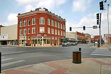 |
(#83002080) |
Main St. from the former Santa Fe railroad tracks to B St., N. Washington from Main to 2nd Ave., NE., and Caddo from Main to the northern side of 2nd Ave., NE. 34°10′16″N 97°07′41″W / 34.171111°N 97.128056°W |
Ardmore | |
| 3 | Ardmore Municipal Auditorium | Upload image | (#06000117) |
220 West Broadway 34°10′27″N 97°07′50″W / 34.174167°N 97.130556°W |
Ardmore | |
| 4 | Bethel Missionary Baptist Church | Upload image | (#94001519) |
Southeastern corner of the junction of Webster and Lane Sts. 34°28′56″N 97°27′41″W / 34.482222°N 97.461389°W |
Tatums | |
| 5 | Black Theater of Ardmore | Upload image | (#84002978) |
536 E. Main St. 34°10′13″N 97°07′22″W / 34.170278°N 97.122778°W |
Ardmore | |
| 6 | Brady Cabin | Upload image | (#77001090) |
38 miles northwest of Ardmore 34°25′21″N 97°25′45″W / 34.4225°N 97.429167°W |
Ardmore | |
| 7 | Carter County Courthouse | 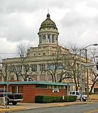 |
(#85000678) |
1st and B Sts., SW. 34°10′19″N 97°07′47″W / 34.171944°N 97.129722°W |
Ardmore | |
| 8 | Central Park Bandstand | 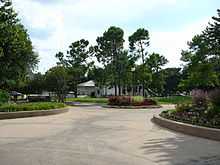 |
(#06001111) |
Southwest of the junction of W. Main and E St., SW. in about the middle of Central Park 34°10′25″N 97°08′03″W / 34.173611°N 97.134167°W |
Ardmore | |
| 9 | Choctaw, Oklahoma and Gulf Railroad Viaduct | Upload image | (#07001266) |
Junction of G St., NE. and the abandoned roadbed of the St. Louis – San Francisco Railway 34°10′44″N 97°07′06″W / 34.178889°N 97.118333°W |
Ardmore | |
| 10 | Dornick Hills Country Club | Upload image | (#03000877) |
519 N. Country Club Rd. 34°13′12″N 97°08′15″W / 34.22°N 97.1375°W |
Ardmore | |
| 11 | Douglass High School Auditorium | Upload image | (#84002981) |
800 M St., NE. 34°10′49″N 97°07′21″W / 34.180278°N 97.1225°W |
Ardmore | |
| 12 | Dunbar School | Upload image | (#84002985) |
13 6th St., SE. 34°10′10″N 97°07′14″W / 34.169444°N 97.120556°W |
Ardmore | |
| 13 | Galt-Franklin Home | Upload image | (#86001132) |
400 Country Club Rd. 34°12′56″N 97°08′08″W / 34.215556°N 97.135556°W |
Ardmore | |
| 14 | Hardy Murphy Coliseum | Upload image | (#06000118) |
600 Lake Murray Dr., S. 34°09′42″N 97°07′11″W / 34.161667°N 97.119722°W |
Ardmore | |
| 15 | Healdton Armory | Upload image | (#94000280) |
Junction of 4th and Franklin Sts. 34°14′01″N 97°29′13″W / 34.233611°N 97.486944°W |
Healdton | |
| 16 | Healdton Oil Field Bunk House | Upload image | (#85002518) |
North of Wilson 34°13′02″N 97°24′34″W / 34.217222°N 97.409444°W |
Wilson | |
| 17 | Johnson Home | Upload image | (#86001133) |
400 Country Club Rd. 34°12′54″N 97°08′04″W / 34.215°N 97.134444°W |
Ardmore | |
| 18 | Lake Murray State Park |  |
(#01001097) |
1.9 miles southeast of the junction of U.S. Routes 70 and 77 34°04′56″N 97°04′13″W / 34.082222°N 97.070278°W |
Ardmore | |
| 19 | Oklahoma, New Mexico and Pacific Railroad Depot | Upload image | (#82003671) |
N. Washington and NE. 3rd 34°10′35″N 97°07′36″W / 34.176389°N 97.126667°W |
Ardmore | |
| 20 | Sayre-Mann House | Upload image | (#82003672) |
323 F St., SW. 34°10′07″N 97°08′09″W / 34.168611°N 97.135833°W |
Ardmore | |
| 21 | Turner House | Upload image | (#13000703) |
1501 3rd Ave., SW. Coordinates missing |
Ardmore | |
| 22 | Zaneis School Teacher's Dormitory | Upload image | (#85001800) |
Off U.S. Route 70 34°10′20″N 97°29′58″W / 34.172222°N 97.499444°W |
Healdton |
See also
| Wikimedia Commons has media related to National Register of Historic Places in Carter County, Oklahoma. |
- List of National Historic Landmarks in Oklahoma
- National Register of Historic Places listings in Oklahoma
References
- ↑ The latitude and longitude information provided in this table was derived originally from the National Register Information System, which has been found to be fairly accurate for about 99% of listings. For about 1% of NRIS original coordinates, experience has shown that one or both coordinates are typos or otherwise extremely far off; some corrections may have been made. A more subtle problem causes many locations to be off by up to 150 yards, depending on location in the country: most NRIS coordinates were derived from tracing out latitude and longitudes off of USGS topographical quadrant maps created under the North American Datum of 1927, which differs from the current, highly accurate WGS84 GPS system used by most on-line maps. Chicago is about right, but NRIS longitudes in Washington are higher by about 4.5 seconds, and are lower by about 2.0 seconds in Maine. Latitudes differ by about 1.0 second in Florida. Some locations in this table may have been corrected to current GPS standards.
- ↑ "National Register of Historic Places: Weekly List Actions". National Park Service, United States Department of the Interior. Retrieved on May 1, 2015.
- ↑ Numbers represent an ordering by significant words. Various colorings, defined here, differentiate National Historic Landmarks and historic districts from other NRHP buildings, structures, sites or objects.
- ↑ "National Register Information System". National Register of Historic Places. National Park Service. 2009-03-13.
- ↑ The eight-digit number below each date is the number assigned to each location in the National Register Information System database, which can be viewed by clicking the number.
| ||||||||||||||||||||||||||
| |||||||||||||||||||||||||||||