| [3] |
Name on the Register[4] |
Image |
Date listed[5] |
Location |
City or town |
Description |
|---|
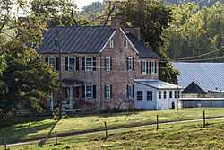
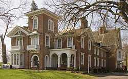
| 1 |
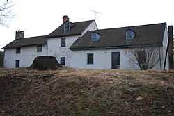
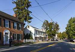
Antrim |
Upload image |
01977-09-16-0000September 16, 1977
(#77000686) |
South of Taneytown on Uniontown Rd.
39°39′15″N 77°10′29″W / 39.654167°N 77.174722°W / 39.654167; -77.174722 (Antrim) |
Taneytown |
|
| 2 |
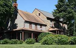
Appler-Englar House |
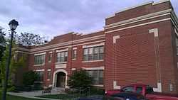
Upload image |
02001-04-05-0000April 5, 2001
(#01000338) |
916 Winter's Church Rd.
39°33′13″N 77°07′42″W / 39.553611°N 77.128333°W / 39.553611; -77.128333 (Appler-Englar House) |
New Windsor |
|
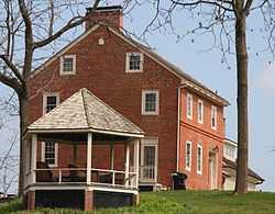
| 3 |
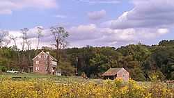
Philip and Uriah Arter Farm |
Upload image |
02006-12-12-0000December 12, 2006
(#06001124) |
10 Deep Run Rd., W.
39°40′10″N 77°00′50″W / 39.669522°N 77.013956°W / 39.669522; -77.013956 (Philip and Uriah Arter Farm) |
Union Mills |
|
| 4 |
Solomon Arter House |
Upload image |
01987-09-10-0000September 10, 1987
(#87001569) |
4029 Geeting Rd.
39°41′11″N 76°59′27″W / 39.686389°N 76.990833°W / 39.686389; -76.990833 (Solomon Arter House) |
Union Mills |
|
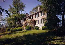
| 5 |
Avalon |
Upload image |
01987-09-03-0000September 3, 1987
(#87001407) |
Maryland Route 31
39°32′30″N 77°05′38″W / 39.541667°N 77.093889°W / 39.541667; -77.093889 (Avalon) |
New Windsor |
|
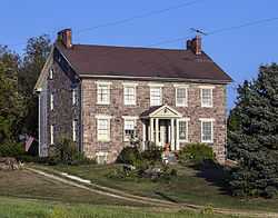
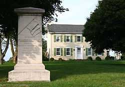
| 6 |
Avondale |
Upload image |
01975-10-10-0000October 10, 1975
(#75000877) |
2.5 miles southwest of Westminster on Maryland Route 31
39°33′33″N 77°01′49″W / 39.559167°N 77.030278°W / 39.559167; -77.030278 (Avondale) |
Westminster |
|
| 7 |
Bennett-Kelly Farm |
Upload image |
02004-12-23-0000December 23, 2004
(#04001378) |
5842 Oakland Rd.
39°24′51″N 76°53′46″W / 39.414167°N 76.896111°W / 39.414167; -76.896111 (Bennett-Kelly Farm) |
Sykesville |
|
| 8 |
William and Catherine Biggs Farm |
Upload image |
02001-11-02-0000November 2, 2001
(#01001197) |
8212 Sixes Bridge Rd.
39°37′40″N 77°17′12″W / 39.627778°N 77.286667°W / 39.627778; -77.286667 (William and Catherine Biggs Farm) |
Detour |
|
| 9 |
Branton Manor |
|
01978-08-18-0000August 18, 1978
(#78001450) |
2819 Old Liberty Rd.
39°23′42″N 76°53′43″W / 39.395°N 76.895278°W / 39.395; -76.895278 (Branton Manor) |
Sykesville |
|
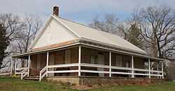
| 10 |
Moses Brown House |
|
01980-12-11-0000December 11, 1980
(#80001800) |
Southeast of Eldersburg at 7604 Ridge Rd.
39°23′18″N 76°55′36″W / 39.388333°N 76.926667°W / 39.388333; -76.926667 (Moses Brown House) |
Eldersburg |
|
| 11 |
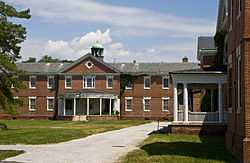
Carroll County Almshouse and Farm |
Upload image |
01975-12-04-0000December 4, 1975
(#75000878) |
500 S. Center St.
39°33′30″N 76°59′44″W / 39.558333°N 76.995556°W / 39.558333; -76.995556 (Carroll County Almshouse and Farm) |
Westminster |
|
| 12 |
Whittaker Chambers Farm |
Upload image |
01988-05-17-0000May 17, 1988
(#88001824) |
E. Saw Mill Rd.
39°39′35″N 76°58′35″W / 39.659722°N 76.976389°W / 39.659722; -76.976389 (Whittaker Chambers Farm) |
Westminster |
|
| 13 |
Cold Saturday |
Upload image |
02008-12-11-0000December 11, 2008
(#08001174) |
3251 Gamber Rd.
39°29′07″N 76°54′09″W / 39.485297°N 76.902392°W / 39.485297; -76.902392 (Cold Saturday) |
Finksburg |
|
| 14 |
Englar-Schweigart-Rinehart Farm |
Upload image |
02003-12-10-0000December 10, 2003
(#03001267) |
47 Rockland Rd.
39°34′50″N 77°02′20″W / 39.580556°N 77.038889°W / 39.580556; -77.038889 (Englar-Schweigart-Rinehart Farm) |
Westminster |
|
| 15 |
Christopher Erb House |
|
01985-06-19-0000June 19, 1985
(#85001269) |
3333 Flickinger Rd.
39°39′52″N 77°05′06″W / 39.664444°N 77.085°W / 39.664444; -77.085 (Christopher Erb House) |
Silver Run |
|
| 16 |
Farm Content |
Upload image |
01975-06-20-0000June 20, 1975
(#75000879) |
On Old New Winsor Rd. off Maryland Route 31
39°33′31″N 77°02′30″W / 39.558611°N 77.041667°W / 39.558611; -77.041667 (Farm Content) |
Westminster |
|
| 17 |
Friendship Valley Farm |
Upload image |
01977-09-16-0000September 16, 1977
(#77000688) |
South of Westminster at 950 Gist Rd.
39°32′49″N 77°00′04″W / 39.546944°N 77.001111°W / 39.546944; -77.001111 (Friendship Valley Farm) |
Westminster |
|
| 18 |
Andrew P. Frizzell House and Farm Complex |
Upload image |
01986-09-11-0000September 11, 1986
(#86002391) |
3801 Salem Bottom Rd.
39°27′30″N 77°03′08″W / 39.458333°N 77.052222°W / 39.458333; -77.052222 (Andrew P. Frizzell House and Farm Complex) |
Westminster |
|
| 19 |
Hampstead School |
|
02002-12-27-0000December 27, 2002
(#02001575) |
1211 N. Main St.
39°36′28″N 76°50′59″W / 39.607778°N 76.849722°W / 39.607778; -76.849722 (Hampstead School) |
Hampstead |
|
| 20 |
Hard Lodging |
|
01978-06-09-0000June 9, 1978
(#78001451) |
1 mile (1.6 km) east of Union Bridge on Ladiesburg Rd.
39°33′54″N 77°09′56″W / 39.565°N 77.165556°W / 39.565; -77.165556 (Hard Lodging) |
Union Bridge |
|
| 21 |
Isaac Hoffman House |
Upload image |
01985-07-25-0000July 25, 1985
(#85001612) |
364 Shamer Lane
39°35′18″N 76°53′20″W / 39.588333°N 76.888889°W / 39.588333; -76.888889 (Isaac Hoffman House) |
Houcksville |
|
| 22 |
Hopewell |
|
01980-12-08-0000December 8, 1980
(#80001803) |
Pearre and Clemsonville Rds.
39°31′48″N 77°10′13″W / 39.53°N 77.170278°W / 39.53; -77.170278 (Hopewell) |
Union Bridge |
|
| 23 |
Keefer-Brubaker Farm |
Upload image |
02007-12-20-0000December 20, 2007
(#07001286) |
2719 Roop Rd.
39°39′22″N 77°12′13″W / 39.656111°N 77.203611°W / 39.656111; -77.203611 (Keefer-Brubaker Farm) |
Taneytown |
|
| 24 |
Jacob Koons Farm |
|
02011-05-25-0000May 25, 2011
(#11000306) |
1151 Otterdale Mill Rd.
39°36′37″N 77°10′12″W / 39.610278°N 77.17°W / 39.610278; -77.17 (Jacob Koons Farm) |
Taneytown vicinity |
|
| 25 |
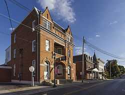
Lineboro Historic District |
Upload image |
01996-11-15-0000November 15, 1996
(#96001350) |
Main St, Church to Mill Sts.
39°36′27″N 76°10′04″W / 39.60744°N 76.16775°W / 39.60744; -76.16775 (Lineboro Historic District) |
Lineboro |
|
| 26 |
Linwood Historic District |
Upload image |
01980-09-27-0000September 27, 1980
(#80001801) |
McKinstry's Mill Rd.
39°33′39″N 77°08′30″W / 39.560833°N 77.141667°W / 39.560833; -77.141667 (Linwood Historic District) |
Linwood |
|
| 27 |
McKinstry's Mills Historic District |
|
01997-04-16-0000April 16, 1997
(#97000338) |
1494, 1498, and 10904 McKinstry's Mill Rd., 4500 and 4504 Sam's Creek Rd.
39°32′00″N 77°09′32″W / 39.533333°N 77.158897°W / 39.533333; -77.158897 (McKinstry's Mills Historic District) |
Union Bridge |
|
| 28 |
McMurray-Frizzell-Aldridge Farm |
|
02001-04-13-0000April 13, 2001
(#01000339) |
3708 Baker Rd.
39°28′19″N 77°03′20″W / 39.47186°N 77.05546°W / 39.47186; -77.05546 (McMurray-Frizzell-Aldridge Farm) |
Westminster |
|
| 29 |
Meadow Brook Farm |
Upload image |
01985-07-25-0000July 25, 1985
(#85001622) |
1006 Taneytown Pike
39°35′31″N 77°01′52″W / 39.591944°N 77.031111°W / 39.591944; -77.031111 (Meadow Brook Farm) |
Westminster |
|
| 30 |
Mount Airy Historic District |
|
01984-09-13-0000September 13, 1984
(#84001589) |
Roughly Main, Church, Maple, Park, Hill, and Warfield Sts.
39°22′31″N 77°09′21″W / 39.375278°N 77.155833°W / 39.375278; -77.155833 (Mount Airy Historic District) |
Mount Airy |
|
| 31 |
Mt. Pleasant |
|
01998-11-04-0000November 4, 1998
(#98001260) |
200 W. Locust St.
39°34′28″N 77°10′57″W / 39.574444°N 77.1825°W / 39.574444; -77.1825 (Mt. Pleasant) |
Union Bridge |
|
| 32 |
New Windsor Historic District |
Upload image |
01997-08-21-0000August 21, 1997
(#97000925) |
Roughly bounded by Park, and Springdale Aves., New Windsor Rd., Lambert Ave., Coe Dr., and Maine St.
39°32′33″N 77°06′21″W / 39.5425°N 77.105833°W / 39.5425; -77.105833 (New Windsor Historic District) |
New Windsor |
|
| 33 |
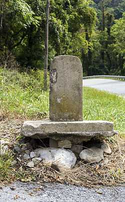
Old National Pike Milestones |
|
01975-11-27-0000November 27, 1975
(#75002107) |
U.S. Route 40, U.S. Route 40 Alternate, and U.S. Route 40 Scenic, and Maryland Routes 144 and 165
39°25′13″N 77°16′01″W / 39.420278°N 77.266944°W / 39.420278; -77.266944 (Old National Pike Milestones) |
Mount Airy |
|
| 34 |
John Orendorff Farm |
Upload image |
01997-03-07-0000March 7, 1997
(#97000102) |
412 Old Bachman's Valley Rd.
39°37′04″N 76°59′16″W / 39.617778°N 76.987778°W / 39.617778; -76.987778 (John Orendorff Farm) |
Westminster |
|
| 35 |
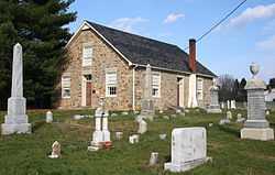
Pipe Creek Friends Meetinghouse |
|
01976-11-07-0000November 7, 1976
(#76000983) |
Quaker Hill Rd.
39°33′48″N 77°10′13″W / 39.563333°N 77.170278°W / 39.563333; -77.170278 (Pipe Creek Friends Meetinghouse) |
Union Bridge |
|
| 36 |
Rockland Farm |
Upload image |
01986-08-21-0000August 21, 1986
(#86001730) |
201 Rockland Rd.
39°34′30″N 77°02′50″W / 39.575°N 77.047222°W / 39.575; -77.047222 (Rockland Farm) |
Westminster |
|
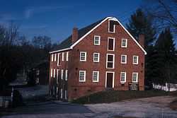
| 37 |
Roop's Mill |
Upload image |
02008-10-31-0000October 31, 2008
(#08000796) |
1001 and 1019 Taneytown Pike
39°35′30″N 77°02′02″W / 39.5918°N 77.0338°W / 39.5918; -77.0338 (Roop's Mill) |
Westminster |
|
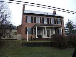
| 38 |
Christian Royer House |
Upload image |
01979-11-07-0000November 7, 1979
(#79001119) |
North of Westminster on Fridinger Mill Rd.
39°37′32″N 76°57′57″W / 39.625556°N 76.965833°W / 39.625556; -76.965833 (Christian Royer House) |
Westminster |
|
| 39 |
Ludwick Rudisel Tannery House |
|
01980-11-10-0000November 10, 1980
(#80001802) |
65 Frederick St.
39°39′27″N 77°10′45″W / 39.6575°N 77.179167°W / 39.6575; -77.179167 (Ludwick Rudisel Tannery House) |
Taneytown |
|
| 40 |
Robert and Phyllis Scott House |
Upload image |
02004-12-23-0000December 23, 2004
(#04001377) |
1805 Uniontown Rd.
39°35′12″N 77°03′40″W / 39.586667°N 77.061111°W / 39.586667; -77.061111 (Robert and Phyllis Scott House) |
Westminster |
|
| 41 |
Jacob F. Shaffer Farm |
Upload image |
01998-10-22-0000October 22, 1998
(#98001259) |
4758 Schalk Road One
39°42′N 76°50′W / 39.7°N 76.83°W / 39.7; -76.83 (Jacob F. Shaffer Farm) |
Millers |
|
| 42 |
Slagle-Byers House |
Upload image |
02007-06-21-0000June 21, 2007
(#07000566) |
1624 Littlestown Pike
39°37′17″N 76°59′51″W / 39.621389°N 76.9975°W / 39.621389; -76.9975 (Slagle-Byers House) |
Westminster |
|
| 43 |
Springfield Presbyterian Church |
|
01986-07-31-0000July 31, 1986
(#86002110) |
7300 Spout Hill Rd.
39°22′27″N 76°58′24″W / 39.374167°N 76.973333°W / 39.374167; -76.973333 (Springfield Presbyterian Church) |
Sykesville |
|
| 44 |
Stoner-Saum Farm |
|
01996-12-06-0000December 6, 1996
(#96001415) |
1500 McKinstry's Mill Rd.
39°32′05″N 77°09′54″W / 39.534722°N 77.165°W / 39.534722; -77.165 (Stoner-Saum Farm) |
Union Bridge |
|
| 45 |
Sykesville Historic District |
|
01985-09-25-0000September 25, 1985
(#85002498) |
Main St. and Springfield, Norwood, and Mellor Aves.
39°22′05″N 76°58′09″W / 39.368056°N 76.969167°W / 39.368056; -76.969167 (Sykesville Historic District) |
Sykesville |
|
| 46 |
Taneytown Historic District |
|
01986-10-09-0000October 9, 1986
(#86002850) |
Maryland Routes 140 and 194
39°39′30″N 77°10′26″W / 39.658333°N 77.173889°W / 39.658333; -77.173889 (Taneytown Historic District) |
Taneytown |
|
| 47 |
Taylor-Manning-Leppo House |
Upload image |
02009-07-15-0000July 15, 2009
(#09000519) |
2600 Patapsco Rd.
39°32′27″N 76°54′00″W / 39.540872°N 76.900119°W / 39.540872; -76.900119 (Taylor-Manning-Leppo House) |
Finksburg |
|
| 48 |
Terra Rubra |
|
01978-07-24-0000July 24, 1978
(#78001449) |
1 mile (1.6 km) south of Keysville
39°37′30″N 77°14′56″W / 39.625°N 77.248889°W / 39.625; -77.248889 (Terra Rubra) |
Keysville |
|
| 49 |
Trevanion |
|
01977-09-15-0000September 15, 1977
(#77000687) |
3 miles northwest of Uniontown on Trevanion Rd.
39°37′28″N 77°07′01″W / 39.624444°N 77.116944°W / 39.624444; -77.116944 (Trevanion) |
Uniontown |
|
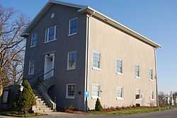
| 50 |
Union Bridge Historic District |
|
01994-08-17-0000August 17, 1994
(#94000820) |
Roughly bounded by Bellevue, E. Locust, Buttersburg Alley, Church, Whyte, W. Locust, and the Western Maryland Railway tracks
39°34′03″N 77°10′40″W / 39.5675°N 77.177778°W / 39.5675; -77.177778 (Union Bridge Historic District) |
Union Bridge |
|
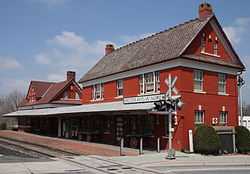
| 51 |
Union Bridge Station |
|
01976-11-07-0000November 7, 1976
(#76000984) |
Main St.
39°34′14″N 77°10′39″W / 39.570556°N 77.1775°W / 39.570556; -77.1775 (Union Bridge Station) |
Union Bridge |
Operated by the Western Maryland Railway
|
| 52 |
Union Mills Homestead Historic District |
|
01971-01-25-0000January 25, 1971
(#71000371) |
Junction of U.S. Route 140 and Deep Run Rd.
39°40′14″N 77°00′58″W / 39.670556°N 77.016111°W / 39.670556; -77.016111 (Union Mills Homestead Historic District) |
Westminster |
|
| 53 |
Uniontown Academy |
Upload image |
01973-08-14-0000August 14, 1973
(#73000911) |
Uniontown Rd.
39°35′32″N 77°10′57″W / 39.592222°N 77.1825°W / 39.592222; -77.1825 (Uniontown Academy) |
Uniontown |
|
| 54 |
Uniontown Historic District |
|
01986-01-03-0000January 3, 1986
(#86000059) |
Uniontown and Trevanion Rds.
39°35′40″N 77°06′55″W / 39.594444°N 77.115278°W / 39.594444; -77.115278 (Uniontown Historic District) |
Uniontown |
|
| 55 |
Warfield Complex, Hubner, and T Buildings |
|
02000-11-02-0000November 2, 2000
(#00001271) |
Springfield Hospital Center
39°22′43″N 76°57′41″W / 39.37861°N 76.96139°W / 39.37861; -76.96139 (Warfield Complex, Hubner, and T Buildings) |
Sykesville |
|
| 56 |
Weaver-Fox House |
Upload image |
01975-11-20-0000November 20, 1975
(#75000876) |
3411 Main St. (Uniontown Rd.)
39°35′36″N 77°06′53″W / 39.593333°N 77.114722°W / 39.593333; -77.114722 (Weaver-Fox House) |
Uniontown |
|
| 57 |
Wesley Chapel Methodist Episcopal Church |
|
01984-03-22-0000March 22, 1984
(#84001593) |
Liberty and Johnsville Rds.
39°24′26″N 76°57′45″W / 39.407222°N 76.9625°W / 39.407222; -76.9625 (Wesley Chapel Methodist Episcopal Church) |
Eldersburg |
|
| 58 |
Western Maryland College Historic District |
|
01976-03-26-0000March 26, 1976
(#76000985) |
W. Main and College Sts.
39°34′53″N 77°00′09″W / 39.581389°N 77.0025°W / 39.581389; -77.0025 (Western Maryland College Historic District) |
Westminster |
|
| 59 |
Westminster Historic District |
|
01980-08-06-0000August 6, 1980
(#80001804) |
Maryland Routes 32 and 97
39°34′30″N 76°59′43″W / 39.575°N 76.995278°W / 39.575; -76.995278 (Westminster Historic District) |
Westminster |
|
| 60 |
Wilson's Inheritance |
Upload image |
01985-06-19-0000June 19, 1985
(#85001270) |
4400 Green Valley Rd.
39°34′16″N 77°09′35″W / 39.571111°N 77.159722°W / 39.571111; -77.159722 (Wilson's Inheritance) |
Union Bridge |
|
| 61 |
Winemiller Family Farm |
Upload image |
02006-08-30-0000August 30, 2006
(#06000743) |
1909 Francis Scott Key Highway (Maryland Route 194)
39°37′46″N 77°13′12″W / 39.629444°N 77.22°W / 39.629444; -77.22 (Winemiller Family Farm) |
Taneytown |
|