National Register of Historic Places listings in Cape Cod National Seashore
This is a list of the National Register of Historic Places listings in Cape Cod National Seashore.
This is intended to be a complete list of the properties and districts on the National Register of Historic Places in Cape Cod National Seashore, Massachusetts, United States. The locations of National Register properties and districts for which the latitude and longitude coordinates are included below, may be seen in a Google map.[1]
There are 25 properties and districts listed on the National Register in the park, one of which is a National Historic Landmark.
- This National Park Service list is complete through NPS recent listings posted May 1, 2015.[2]
Current listings
| [3] | Name on the Register | Image | Date listed[4] | Location | City or town | Description |
|---|---|---|---|---|---|---|
| 1 | Ahearn House and Summer House | 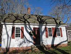 |
(#84000575) |
Pamet Point Rd. 41°57′33″N 70°02′42″W / 41.9592°N 70.045°W |
Wellfleet | |
| 2 | Atwood-Higgins Historic District |  |
(#10000508) |
Bound Brook Island Rd. 41°57′12″N 70°03′26″W / 41.9533°N 70.0572°W |
Wellfleet | Expansion of an earlier listing of the Thomas Atwood House. |
| 3 | Fort Hill Rural Historic District |  |
(#00001656) |
Fort Hill Rd, Cape Cod National Seashore 41°49′10″N 69°57′56″W / 41.8194°N 69.9656°W |
Eastham | |
| 4 | The Beacon | 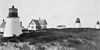 |
(#87001527) |
Off Cable Rd. 41°50′42″N 69°57′36″W / 41.845°N 69.96°W |
Eastham | The longest-used of the Three Sisters of Nauset. The other two are listed separately (see Three Sisters of Nauset (Twin Lights) below); the three decommissioned lighthouses have since been reunited. |
| 5 | French Cable Hut | 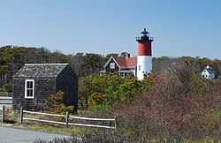 |
(#76000153) |
East of North Eastham at the junction of Cable Rd. and Ocean View Dr. 41°51′34″N 69°57′07″W / 41.8594°N 69.9519°W |
North Eastham | |
| 6 | Ruth and Robert Hatch, Jr., House |  |
(#14000018) |
309 Bound Brook Way 41°57′21″N 70°04′29″W / 41.955969°N 70.074643°W |
Wellfleet | Mid 20th Century Modern Residential Architecture on Outer Cape Cod MPS |
| 7 | Jedediah Higgins House |  |
(#84000550) |
Higgins Hollow Rd. 42°00′35″N 70°03′06″W / 42.0097°N 70.0517°W |
North Truro | |
| 8 | Highland House |  |
(#75000157) |
Off U.S. Route 6 on Cape Cod National Seashore 42°02′25″N 70°03′56″W / 42.0403°N 70.0656°W |
Truro | |
| 9 | Highland Light Station |  |
(#87001463) |
Off U.S. Route 6 42°02′48″N 70°04′10″W / 42.046667°N 70.069444°W |
Truro | |
| 10 | Peter Kugel House |  |
(#14000019) |
188 Long Pond Rd. 41°56′40″N 69°59′53″W / 41.944321°N 69.998033°W |
Wellfleet | Mid 20th Century Modern Residential Architecture on Outer Cape Cod MPS |
| 11 | Samuel and Minette Kuhn House | Upload image | (#14000020) |
420 Griffins Island Rd. 41°56′45″N 70°04′06″W / 41.945744°N 70.068283°W |
Wellfleet | Mid 20th Century Modern Residential Architecture on Outer Cape Cod MPS |
| 12 | Marconi Wireless Station Site |  |
(#75000158) |
1 mile northeast of Cape Cod National Seashore 41°54′50″N 69°58′20″W / 41.9139°N 69.9722°W |
South Wellfleet | |
| 13 | Nauset Archeological District |  |
(#93000607) |
Fort Hill Road area 41°49′08″N 69°57′46″W / 41.8189°N 69.9629°W |
Eastham | |
| 14 | Nauset Beach Light | 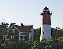 |
(#87001484) |
Nauset Beach 41°51′15″N 69°57′06″W / 41.8542°N 69.9517°W |
Eastham | |
| 15 | John Newcomb House | 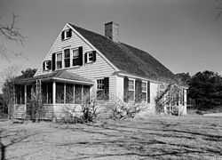 |
(#88001457) |
near Williams Pond 41°57′53″N 70°00′23″W / 41.9647°N 70.0064°W |
Wellfleet | Also known as Thoreau's "House of the Wellfleet Oysterman" |
| 16 | Old Harbor U.S. Life Saving Station | 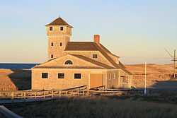 |
(#75000159) |
Northeast of Chatham on Nauset Beach 41°41′52″N 69°55′46″W / 41.6978°N 69.9294°W |
Chatham | |
| 17 | Edward Penniman House and Barn | 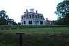 |
(#76000155) |
South of Eastham at Fort Hill and Governor Prence Rds. 41°49′07″N 69°57′57″W / 41.8185°N 69.9657°W |
Eastham | |
| 18 | Pine Grove Cemetery | 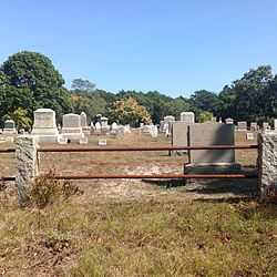 |
(#13000096) |
Cemetery Rd. 41°58′34″N 70°03′34″W / 41.975987°N 70.059435°W |
Truro | |
| 19 | Race Point Light Station | 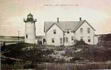 |
(#87001482) |
Race Point Beach 42°03′40″N 70°14′33″W / 42.0611°N 70.2425°W |
Provincetown | |
| 20 | Anthony and Allison Sirna Studio | 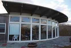 |
(#14000021) |
60 Way #4 41°57′29″N 69°59′38″W / 41.958045°N 69.99397°W |
Wellfleet | Mid 20th Century Modern Residential Architecture on Outer Cape Cod MPS |
| 21 | Samuel Smith Tavern Site | 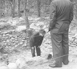 |
(#77000108) |
Great Island 41°55′12″N 70°03′26″W / 41.919906°N 70.05711°W |
Wellfleet | 17th century tavern site accessible via Great Island Trail |
| 22 | Three Sisters of Nauset (Twin Lights) | 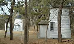 |
(#87001502) |
Off Cable Rd. 41°50′42″N 69°57′36″W / 41.845°N 69.96°W |
Eastham | Two of the three decommissioned lighthouses of the Three Sisters of Nauset; The Beacon (listed separately) is the third. At the time of their nomination, these two lights were separate from The Beacon; they have since been reunited. |
| 23 | Vera and Laszlo Tisza House | 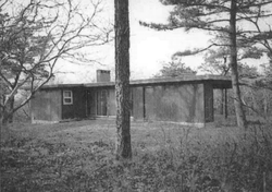 |
(#14000022) |
2 Deer Trail 41°57′36″N 69°59′55″W / 41.960074°N 69.998642°W |
Wellfleet | Mid 20th Century Modern Residential Architecture on Outer Cape Cod MPS |
| 24 | Truro Highlands Historic District | 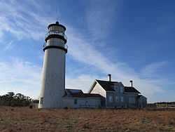 |
(#11000823) |
Highland Light Rd. 42°02′22″N 70°03′44″W / 42.039342°N 70.062253°W |
Truro | Includes Highland Light, Highland House, and other buildings along Highland Light Road. |
| 25 | Paul and Madeleine Weidlinger House |  |
(#14000023) |
54 Valley Rd. 41°57′36″N 70°00′24″W / 41.960013°N 70.006628°W |
Wellfleet | Mid 20th Century Modern Residential Architecture on Outer Cape Cod MPS |
See also
- National Register of Historic Places listings in Barnstable County, Massachusetts
- List of National Historic Landmarks in Massachusetts
- National Register of Historic Places listings in Massachusetts
References
- ↑ The latitude and longitude information provided in this table was derived originally from the National Register Information System, which has been found to be fairly accurate for about 99% of listings. For about 1% of NRIS original coordinates, experience has shown that one or both coordinates are typos or otherwise extremely far off; some corrections may have been made. A more subtle problem causes many locations to be off by up to 150 yards, depending on location in the country: most NRIS coordinates were derived from tracing out latitude and longitudes off of USGS topographical quadrant maps created under the North American Datum of 1927, which differs from the current, highly accurate WGS84 GPS system used by most on-line maps. Chicago is about right, but NRIS longitudes in Washington are higher by about 4.5 seconds, and are lower by about 2.0 seconds in Maine. Latitudes differ by about 1.0 second in Florida. Some locations in this table may have been corrected to current GPS standards.
- ↑ "National Register of Historic Places: Weekly List Actions". National Park Service, United States Department of the Interior. Retrieved on May 1, 2015.
- ↑ Numbers represent an ordering by significant words. Various colorings, defined here, differentiate National Historic Landmarks and historic districts from other NRHP buildings, structures, sites or objects.
- ↑ The eight-digit number below each date is the number assigned to each location in the National Register Information System database, which can be viewed by clicking the number.
External links
| Wikimedia Commons has media related to National Register of Historic Places in Cape Cod National Seashore. |
| ||||||||||||||||||
| |||||||||||||||||||||||||||||||||||||||||||||||||||||||
