National Register of Historic Places listings in Canyon County, Idaho

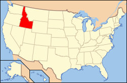
Location of Canyon County in Idaho
This is a list of the National Register of Historic Places listings in Canyon County, Idaho.
This is intended to be a complete list of the properties and districts on the National Register of Historic Places in Canyon County, Idaho, United States. Latitude and longitude coordinates are provided for many National Register properties and districts; these locations may be seen together in a Google map.[1]
There are 46 properties and districts listed on the National Register in the county. More may be added; properties and districts nationwide are added to the Register weekly.[2]
- This National Park Service list is complete through NPS recent listings posted May 1, 2015.[3]
Current listings
| [4] | Name on the Register[5] | Image | Date listed[6] | Location | City or town | Description |
|---|---|---|---|---|---|---|
| 1 | F. F. Beale House | Upload image | (#93000386) |
1802 Cleveland Boulevard 43°39′25″N 116°40′46″W / 43.656821°N 116.679326°W |
Caldwell | |
| 2 | Blatchley Hall | Upload image | (#78001055) |
College of Idaho campus 43°39′09″N 116°40′31″W / 43.652404°N 116.675328°W |
Caldwell | |
| 3 | Boise River and Canal Bridge | Upload image | (#07000003) |
Plymouth St. 43°41′20″N 116°41′13″W / 43.688899°N 116.686844°W |
Caldwell | |
| 4 | Caldwell Carnegie Library | Upload image | (#79000784) |
1101 Cleveland Boulevard 43°39′44″N 116°41′10″W / 43.662172°N 116.686124°W |
Caldwell | |
| 5 | Caldwell Historic District | Upload image | (#82002509) |
Roughly bounded by Railroad and Arthur Sts. and 7th and 9th Aves. 43°39′59″N 116°41′16″W / 43.666390°N 116.687872°W |
Caldwell | |
| 6 | Caldwell Odd Fellow Home for the Aged | Upload image | (#82000322) |
N. 14th Ave. 43°39′59″N 116°40′24″W / 43.666408°N 116.673251°W |
Caldwell | |
| 7 | Caldwell Residential Historic District | Upload image | (#02001064) |
Roughly bounded by Cleveland Boulevard, Everett St., S. 12th Ave., and S. 20th Ave. 43°39′28″N 116°40′56″W / 43.657885°N 116.682305°W |
Caldwell | |
| 8 | E. H. Dewey Stores | .jpg) |
(#82000323) |
1013-1015 1st St., S. 43°34′47″N 116°33′41″W / 43.579646°N 116.561474°W |
Nampa | |
| 9 | Diversion Dam and Deer Flat Embankments | 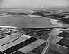 |
(#76000666) |
Southeast of Boise on the Boise River 43°34′26″N 116°42′23″W / 43.573889°N 116.706389°W |
Boise vicinity | Extends into Ada County |
| 10 | Henry W. and Ida Frost Dorman House | Upload image | (#00000756) |
114 E. Logan St. 43°39′17″N 116°41′50″W / 43.654812°N 116.697274°W |
Caldwell | |
| 11 | Farmers and Merchants Bank | .jpg) |
(#76000670) |
101 11th Ave., S. 43°34′46″N 116°33′40″W / 43.579534°N 116.561245°W |
Nampa | |
| 12 | Fort Boise and Riverside Ferry Sites | 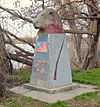 |
(#74000736) |
Northwest of Parma on the Snake River 43°49′25″N 117°01′13″W / 43.823644°N 117.020383°W |
Parma vicinity | |
| 13 | Guffey Butte – Black Butte Archeological District | 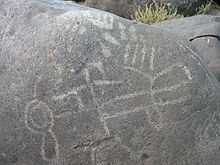 |
(#78001038) |
Along approximately 34 miles (55 km) of the Snake River in Canyon, Ada, Owyhee, and Elmore counties[7] 43°17′57″N 116°31′18″W / 43.299253°N 116.521777°W |
Grand View | |
| 14 | Horse Barn | Upload image | (#78001057) |
Northeast of Nampa at Idaho State School and Hospital 43°36′12″N 116°31′32″W / 43.603228°N 116.525637°W |
Nampa | |
| 15 | Ellen Houlder Farm | Upload image | (#94000631) |
Arena Valley Rd. (Route 2) west of Wilder 43°40′49″N 116°59′28″W / 43.680394°N 116.991113°W |
Wilder | |
| 16 | Idaho State Sanitarium Administration Building | Upload image | (#82000324) |
Northeast of Nampa on 11th Ave., N. 43°36′09″N 116°31′53″W / 43.602455°N 116.531301°W |
Nampa | |
| 17 | Thomas K. Little House | Upload image | (#80001295) |
703 E. Belmont St. 43°40′08″N 116°41′08″W / 43.668829°N 116.685467°W |
Caldwell | |
| 18 | Jacob P. Lockman House | Upload image | (#05000735) |
23 9th Ave. N 43°34′58″N 116°33′40″W / 43.582903°N 116.561160°W |
Nampa | |
| 19 | Map Rock Petroglyphs Historic District | Upload image | (#82000325) |
Map Rock Rd.[8] 43°25′16″N 116°42′17″W / 43.421078°N 116.704667°W |
Givens Hot Springs | |
| 20 | Mercy Hospital | Upload image | (#14000504) |
1615 8th St., S. 43°34′12″N 116°33′45″W / 43.569987°N 116.562380°W |
Nampa | |
| 21 | Middleton Substation | Upload image | (#73000683) |
State Highway 44 43°42′23″N 116°37′07″W / 43.706344°N 116.618536°W |
Middleton | |
| 22 | Nampa American Legion Chateau | .jpg) |
(#82000326) |
1508 2nd St., S. 43°34′33″N 116°33′26″W / 43.575885°N 116.557086°W |
Nampa | |
| 23 | Nampa and Meridian Irrigation District Office | .jpg) |
(#82000329) |
1503 1st St., S. 43°34′35″N 116°33′24″W / 43.576413°N 116.556612°W |
Nampa | |
| 24 | Nampa City Hall | 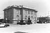 |
(#85000967) |
203 12th Ave., S. 43°34′41″N 116°33′41″W / 43.578051°N 116.561293°W |
Nampa | Demolished in 1991 |
| 25 | Nampa Department Store | Upload image | (#82000327) |
1st St., S. and 13th Ave. 43°34′40″N 116°33′31″W / 43.577765°N 116.558715°W |
Nampa | |
| 26 | Nampa Depot | .jpg) |
(#72000438) |
12th Ave. and Front St. 43°34′47″N 116°33′31″W / 43.579609°N 116.558675°W |
Nampa | |
| 27 | Nampa First Methodist Episcopal Church | Upload image | (#82000328) |
12th Ave., S. and 4th St. 43°34′34″N 116°33′46″W / 43.576210°N 116.562746°W |
Nampa | |
| 28 | Nampa Historic District |  |
(#83000284) |
1200 and 1300 blocks S. 1st St. 43°34′41″N 116°33′31″W / 43.578034°N 116.558694°W |
Nampa | |
| 29 | Nampa Presbyterian Church | 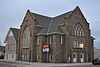 |
(#82000330) |
2nd St. and 15th Ave., S. 43°34′33″N 116°33′29″W / 43.575889°N 116.558007°W |
Nampa | |
| 30 | Nampa Valley Grange No.131 | Upload image | (#13000002) |
203 5th Ave., S. 43°34′59″N 116°34′07″W / 43.583062°N 116.568552°W |
Nampa | |
| 31 | North Caldwell Historic District | Upload image | (#79000785) |
9th, Albany, and Belmont Sts. 43°40′01″N 116°41′03″W / 43.667064°N 116.684258°W |
Caldwell | |
| 32 | George Obendorf Gothic Arch Truss Barn | 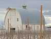 |
(#99001278) |
24047 Batt Corner Rd. 43°43′14″N 116°55′23″W / 43.720474°N 116.922969°W |
Wilder vicinity | |
| 33 | Old Nampa Neighborhood Historic District | Upload image | (#07000164) |
Roughly bounded by 4th Ave., S, 4th St., S, 11th Ave., S, and 9th St., S. 43°34′41″N 116°34′10″W / 43.578120°N 116.569400°W |
Nampa | |
| 34 | Peckham Barn | 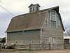 |
(#82000389) |
North of Wilder on U.S. Route 95 43°41′01″N 116°54′37″W / 43.683597°N 116.910336°W |
Wilder vicinity | |
| 35 | John C. Rice House | 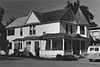 |
(#80001296) |
1520 Cleveland Boulevard 43°39′31″N 116°40′55″W / 43.658583°N 116.681878°W |
Caldwell | Building apparently no longer exists. |
| 36 | Roswell Grade School | .jpg) |
(#82000331) |
State Highway 18 and Stephan Lane 43°44′55″N 116°57′41″W / 43.748696°N 116.961497°W |
Roswell | |
| 37 | Sacred Hearts of Jesus and Mary Church | 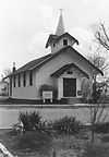 |
(#82000334) |
608 7th St. 43°47′15″N 116°56′17″W / 43.787473°N 116.938141°W |
Parma | Building no longer exists. |
| 38 | St. Mary's Catholic Church | 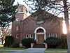 |
(#82000332) |
616 Dearborn St. 43°39′51″N 116°41′32″W / 43.664276°N 116.692252°W |
Caldwell | |
| 39 | St. Paul's Rectory and Sisters' House | 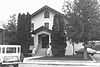 |
(#82000333) |
810 15th Ave., S. 43°34′15″N 116°33′49″W / 43.570822°N 116.563663°W |
Nampa | Building no longer exists. |
| 40 | Sterry Hall | Upload image | (#78001056) |
College of Idaho campus 43°39′14″N 116°40′36″W / 43.653816°N 116.676745°W |
Caldwell | |
| 41 | A. K. Steunenberg House | Upload image | (#82000335) |
409 N. Kimball Ave. 43°40′09″N 116°41′02″W / 43.669193°N 116.683897°W |
Caldwell | |
| 42 | A. H. Stewart House | 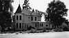 |
(#79000786) |
3rd St. and Bates Ave 43°47′10″N 116°56′37″W / 43.786237°N 116.943682°W |
Parma | Building no longer exists. |
| 43 | Carrie Adell Strahorn Memorial Library | Upload image | (#82002510) |
College of Idaho campus 43°39′10″N 116°40′36″W / 43.652800°N 116.676786°W |
Caldwell | |
| 44 | U.S. Post Office – Caldwell Main | Upload image | (#89000131) |
823 Arthur St. 43°39′55″N 116°41′14″W / 43.665299°N 116.687109°W |
Caldwell | |
| 45 | U.S. Post Office – Nampa Main | .jpg) |
(#89000132) |
123 11th Ave., S. 43°34′45″N 116°33′42″W / 43.579160°N 116.561767°W |
Nampa | |
| 46 | Orton H. Wiley House | Upload image | (#86002163) |
524 E. Dewey Ave. 43°33′49″N 116°33′58″W / 43.563665°N 116.566071°W |
Nampa |
Former listings
| [4] | Name on the Register | Image | Date listed | Date removed | Location | City or town | Summary |
|---|---|---|---|---|---|---|---|
| 1 | Academy Building, College of Idaho | Upload image | (#78001054) | 1015 Albany St. |
Caldwell |
See also
| Wikimedia Commons has media related to National Register of Historic Places in Canyon County, Idaho. |
References
- ↑ The latitude and longitude information provided in this table was derived originally from the National Register Information System, which has been found to be fairly accurate for about 99% of listings. For about 1% of NRIS original coordinates, experience has shown that one or both coordinates are typos or otherwise extremely far off; some corrections may have been made. A more subtle problem causes many locations to be off by up to 150 yards, depending on location in the country: most NRIS coordinates were derived from tracing out latitude and longitudes off of USGS topographical quadrant maps created under the North American Datum of 1927, which differs from the current, highly accurate WGS84 GPS system used by most on-line maps. Chicago is about right, but NRIS longitudes in Washington are higher by about 4.5 seconds, and are lower by about 2.0 seconds in Maine. Latitudes differ by about 1.0 second in Florida. Some locations in this table may have been corrected to current GPS standards.
- ↑ "National Register of Historic Places: Weekly List Actions". National Park Service. Retrieved March 29, 2009.
- ↑ "National Register of Historic Places: Weekly List Actions". National Park Service, United States Department of the Interior. Retrieved on May 1, 2015.
- ↑ 4.0 4.1 Numbers represent an ordering by significant words. Various colorings, defined here, differentiate National Historic Landmarks and historic districts from other NRHP buildings, structures, sites or objects.
- ↑ "National Register Information System". National Register of Historic Places. National Park Service. 2008-04-24.
- ↑ The eight-digit number below each date is the number assigned to each location in the National Register Information System database, which can be viewed by clicking the number.
- ↑ Map #8 - Guffey Butte / Black Butte Historical District (PDF) (Map). Bureau of Land Management. January 28, 2011. Retrieved March 14, 2015. Coordinates mark Celebration Park, which protects a set of archeological resources that are part of the historic district.
- ↑ Canyon County Parks, Recreation and Waterways, Map Rock, retrieved March 14, 2015.

| ||||||||||||||||||||||||||
| |||||||||||||||||