| [3] |
Name on the Register[4] |
Image |
Date listed[5] |
Location |
City or town |
Description |
|---|
| 1 |
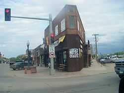
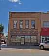
Belle Fourche Commercial Historic District |
|
01982-04-27-0000April 27, 1982
(#82003917) |
500-620 State St. and 608-622 5th Ave.
44°40′20″N 103°51′12″W / 44.672222°N 103.853333°W / 44.672222; -103.853333 (Belle Fourche Commercial Historic District) |
Belle Fourche |
|
| 2 |
Belle Fourche Dam |
|
01977-11-23-0000November 23, 1977
(#77001239) |
East of Belle Fourche off U.S. Route 212
44°44′06″N 103°40′28″W / 44.735°N 103.674444°W / 44.735; -103.674444 (Belle Fourche Dam) |
Belle Fourche |
|
| 3 |
Belle Fourche Experiment Farm |
Upload image |
01976-12-22-0000December 22, 1976
(#76001722) |
Northwest of Newell off Highway 79
44°43′45″N 103°27′01″W / 44.729167°N 103.450278°W / 44.729167; -103.450278 (Belle Fourche Experiment Farm) |
Newell |
|
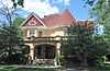
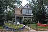
| 4 |
Charles Bolles House |
|
01982-07-01-0000July 1, 1982
(#82003918) |
919 State St.
44°40′18″N 103°50′44″W / 44.671667°N 103.845556°W / 44.671667; -103.845556 (Charles Bolles House) |
Belle Fourche |
|
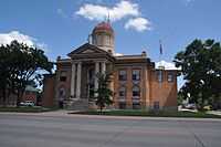
| 5 |
Butte County Courthouse and Historic Jail Building |
|
01998-12-03-0000December 3, 1998
(#98001398) |
839 5th Ave.
44°40′12″N 103°48′54″W / 44.67°N 103.815°W / 44.67; -103.815 (Butte County Courthouse and Historic Jail Building) |
Belle Fourche |
|
| 6 |
Butte-Lawrence County Fairgrounds |
Upload image |
01986-04-30-0000April 30, 1986
(#86000934) |
Southwest of Nisland
44°40′02″N 97°34′04″W / 44.667222°N 97.567778°W / 44.667222; -97.567778 (Butte-Lawrence County Fairgrounds) |
Nisland |
|
| 7 |
Ditchrider House |
Upload image |
02002-01-31-0000January 31, 2002
(#01000172) |
North of U.S. Route 212
44°40′46″N 103°33′31″W / 44.679444°N 103.558611°W / 44.679444; -103.558611 (Ditchrider House) |
Nisland |
|
| 8 |
First Congregational United Church of Christ |
Upload image |
02013-07-30-0000July 30, 2013
(#13000571) |
717 Jackson St
44°40′02″N 103°50′59″W / 44.6671°N 103.8496°W / 44.6671; -103.8496 (First Congregational United Church of Christ) |
Belle Fourche |
|
| 9 |
Fruitdale School |
Upload image |
01986-04-30-0000April 30, 1986
(#86000926) |
High St.
44°40′14″N 97°41′29″W / 44.670556°N 97.691389°W / 44.670556; -97.691389 (Fruitdale School) |
Fruitdale |
|
| 10 |
Fruitdale Store |
Upload image |
01986-04-30-0000April 30, 1986
(#86000927) |
Water and Main Sts.
44°40′09″N 97°41′44″W / 44.669167°N 97.695556°W / 44.669167; -97.695556 (Fruitdale Store) |
Fruitdale |
|
| 11 |
Carl Friedrick Gartner Homestead |
Upload image |
01986-04-30-0000April 30, 1986
(#86000930) |
West of Highway 79
44°42′29″N 97°29′21″W / 44.708056°N 97.489167°W / 44.708056; -97.489167 (Carl Friedrick Gartner Homestead) |
Newell |
|
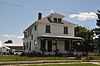
| 12 |
Thomas Haskins Gay House |
|
01982-07-19-0000July 19, 1982
(#82003919) |
704 Harding
44°40′13″N 103°51′00″W / 44.670278°N 103.85°W / 44.670278; -103.85 (Thomas Haskins Gay House) |
Belle Fourche |
|
| 13 |
Fred S. Harris House |
|
01988-07-13-0000July 13, 1988
(#88000575) |
826 State St.
44°40′17″N 103°50′51″W / 44.671389°N 103.8475°W / 44.671389; -103.8475 (Fred S. Harris House) |
Belle Fourche |
|
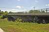
| 14 |
Hay Creek Bridge |
|
01993-12-09-0000December 9, 1993
(#93001274) |
8th Ave. over Hay Creek
44°39′54″N 103°51′05″W / 44.665°N 103.851389°W / 44.665; -103.851389 (Hay Creek Bridge) |
Belle Fourche |
Possibly replaced
|
| 15 |
Hoover Store |
Upload image |
01986-04-30-0000April 30, 1986
(#86000931) |
Highway 79
45°06′45″N 97°16′16″W / 45.1125°N 97.271111°W / 45.1125; -97.271111 (Hoover Store) |
Hoover |
|
| 16 |
Alexander Hoover House |
Upload image |
01986-04-30-0000April 30, 1986
(#86000929) |
Highway 59
45°06′46″N 97°16′06″W / 45.112778°N 97.268333°W / 45.112778; -97.268333 (Alexander Hoover House) |
Hoover |
|
| 17 |
William Johnson House |
Upload image |
01986-04-30-0000April 30, 1986
(#86000928) |
High St.
44°40′14″N 97°41′38″W / 44.670556°N 97.693889°W / 44.670556; -97.693889 (William Johnson House) |
Fruitdale |
|
| 18 |
William G. Kenaston House |
Upload image |
01984-02-23-0000February 23, 1984
(#84003246) |
301 Dartmouth
44°42′54″N 103°25′31″W / 44.715°N 103.425278°W / 44.715; -103.425278 (William G. Kenaston House) |
Newell |
|
| 19 |
Langdon School |
Upload image |
01986-04-30-0000April 30, 1986
(#86000935) |
Snoma Rd.
44°38′59″N 97°28′45″W / 44.649722°N 97.479167°W / 44.649722; -97.479167 (Langdon School) |
Nisland |
|
| 20 |
Lincoln School |
Upload image |
02001-02-09-0000February 9, 2001
(#01000098) |
706 Jackson
44°40′00″N 103°51′00″W / 44.666667°N 103.85°W / 44.666667; -103.85 (Lincoln School) |
Belle Fourche |
|
| 21 |
Minnesela Bridge |
Upload image |
01993-12-09-0000December 9, 1993
(#93001277) |
Local road over Redwater Creek
44°38′28″N 103°49′19″W / 44.641111°N 103.821944°W / 44.641111; -103.821944 (Minnesela Bridge) |
Belle Fourche |
|
| 22 |
Newell Depot Bridge |
Upload image |
01999-08-05-0000August 5, 1999
(#99000953) |
Local road over Horse Creek
44°42′20″N 103°29′10″W / 44.705556°N 103.486111°W / 44.705556; -103.486111 (Newell Depot Bridge) |
Newell |
|
| 23 |
Newell High School |
Upload image |
01986-05-01-0000May 1, 1986
(#86000947) |
Dartmouth St.
44°43′04″N 97°25′34″W / 44.717778°N 97.426111°W / 44.717778; -97.426111 (Newell High School) |
Newell |
|
| 24 |
John Aaron Scotney House |
|
01978-01-03-0000January 3, 1978
(#78002541) |
830 9th St.
44°40′09″N 103°50′55″W / 44.669167°N 103.848611°W / 44.669167; -103.848611 (John Aaron Scotney House) |
Belle Fourche |
|
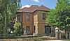
| 25 |
Charles and Eleanor Small House |
Upload image |
01991-11-01-0000November 1, 1991
(#91001617) |
825 5th Ave.
44°40′09″N 103°51′10″W / 44.669167°N 103.852778°W / 44.669167; -103.852778 (Charles and Eleanor Small House) |
Belle Fourche |
|
| 26 |
Snoma Finnish Cemetery |
Upload image |
01985-11-13-0000November 13, 1985
(#85003492) |
3.5 miles southeast of Fruitdale
44°37′59″N 103°41′06″W / 44.633056°N 103.685°W / 44.633056; -103.685 (Snoma Finnish Cemetery) |
Fruitdale |
|
| 27 |
Soper-Behymer Ranch |
Upload image |
01986-06-06-0000June 6, 1986
(#86001262) |
Highway 34
44°38′25″N 98°04′39″W / 44.640278°N 98.0775°W / 44.640278; -98.0775 (Soper-Behymer Ranch) |
Belle Fourche |
|
| 28 |
South Dakota Dept. of Transportation Bridge No. 10-109-360 |
Upload image |
01993-12-09-0000December 9, 1993
(#93001275) |
Local road over the Diversion Dam Inlet Canal in the Belle Fourche Irrigation District
44°41′27″N 103°49′52″W / 44.690833°N 103.831111°W / 44.690833; -103.831111 (South Dakota Dept. of Transportation Bridge No. 10-109-360) |
Belle Fourche |
|
| 29 |
South Dakota Dept. of Transportation Bridge No. 10-270-338 |
Upload image |
02000-02-18-0000February 18, 2000
(#00000124) |
Local road over Horse Creek
44°43′21″N 103°30′22″W / 44.7225°N 103.506111°W / 44.7225; -103.506111 (South Dakota Dept. of Transportation Bridge No. 10-270-338) |
Newell |
|
| 30 |
Stonelake Bridge |
Upload image |
01986-04-30-0000April 30, 1986
(#86000932) |
Winkler Rd.
44°43′21″N 103°30′24″W / 44.7225°N 103.506667°W / 44.7225; -103.506667 (Stonelake Bridge) |
Newell |
|
| 31 |
Tri State Bakery |
|
01993-08-05-0000August 5, 1993
(#93000781) |
705 State St.
44°40′18″N 103°50′58″W / 44.671667°N 103.849444°W / 44.671667; -103.849444 (Tri State Bakery) |
Belle Fourche |
|
| 32 |
Vale Bridge |
Upload image |
01999-08-05-0000August 5, 1999
(#99000954) |
Local road over the Belle Fourche River
44°37′45″N 103°23′13″W / 44.629167°N 103.386944°W / 44.629167; -103.386944 (Vale Bridge) |
Vale |
|
| 33 |
Vale Cut Off Belle Fourche River Bridge |
Upload image |
01986-04-30-0000April 30, 1986
(#86000937) |
7 miles southwest of Newell
44°40′17″N 97°29′32″W / 44.671389°N 97.492222°W / 44.671389; -97.492222 (Vale Cut Off Belle Fourche River Bridge) |
Belle Fourche |
|
| 34 |
Vale School |
Upload image |
01984-08-01-0000August 1, 1984
(#84003250) |
Off Highway 79
44°37′14″N 103°23′53″W / 44.620556°N 103.398056°W / 44.620556; -103.398056 (Vale School) |
Vale |
|
| 35 |
Nicholas Augustus Viken Homestead |
Upload image |
01986-04-30-0000April 30, 1986
(#86000933) |
North of Hope Cemetery Rd.
44°42′51″N 97°28′35″W / 44.714167°N 97.476389°W / 44.714167; -97.476389 (Nicholas Augustus Viken Homestead) |
Newell |
|
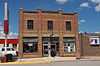
| 36 |
Wide Awake Grocery Building |
|
01978-03-30-0000March 30, 1978
(#78002542) |
520 State St.
44°40′15″N 103°51′02″W / 44.670833°N 103.850556°W / 44.670833; -103.850556 (Wide Awake Grocery Building) |
Belle Fourche |
|