National Register of Historic Places listings in Burnet County, Texas
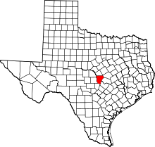
Location of Burnet County in Texas
This is a list of the National Register of Historic Places listings in Burnet County, Texas.
This is intended to be a complete list of properties and districts listed on the National Register of Historic Places in Burnet County, Texas. The locations of National Register properties and districts (at least for all showing latitude and longitude coordinates below) may be seen in a Google map by clicking on "Map of all coordinates".[1]
There are 8 properties and districts listed on the National Register in the county.
- This National Park Service list is complete through NPS recent listings posted May 1, 2015.[2]
Current listings
| [3] | Name on the Register | Image | Date listed[4] | Location | City or town | Description |
|---|---|---|---|---|---|---|
| 1 | Austin and Northwestern Railroad Historic District-Fairland to Llano | 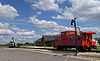 |
(#97001161) |
Roughly along RR tracks from Fairland to Llano 30°38′52″N 98°17′44″W / 30.647778°N 98.295556°W |
Kingsland | Extends into Llano County |
| 2 | Briggs State Bank | 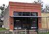 |
(#00000885) |
176 S. Loop 308 (approx. 0.5 mi. N of jct. with US 183) 30°53′17″N 97°55′28″W / 30.888056°N 97.924444°W |
Briggs | |
| 3 | Burnet County Courthouse | 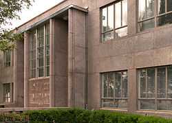 |
(#00001384) |
220 S. Pierce St. 30°45′25″N 98°13′37″W / 30.756944°N 98.226944°W |
Burnet | |
| 4 | Krause Spring Site | 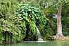 |
(#78002901) |
Off County Rd 404 30°28′50″N 98°08′43″W / 30.480556°N 98.145278°W |
Spicewood | |
| 5 | Louis Page Archeological Site | Upload image | (#78002900) |
Address Restricted |
Marble Falls | |
| 6 | Park Road 4 Historic District | 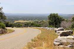 |
(#10001221) |
Park Road 4 from US 281 to TX 29 & Longhorn Cavern State Park 30°42′18″N 98°20′09″W / 30.705°N 98.335972°W |
Burnet vicinity | |
| 7 | Roper Hotel | 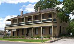 |
(#80004083) |
707 3rd St. 30°34′16″N 98°16′31″W / 30.571111°N 98.275278°W |
Marble Falls | |
| 8 | State Highway 29 Bridge at the Colorado River | 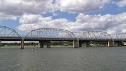 |
(#96001116) |
TX 29 at the Llano County line 30°44′53″N 98°23′54″W / 30.748056°N 98.398333°W |
Buchanan Dam | Extends into Llano County |
See also
| Wikimedia Commons has media related to National Register of Historic Places in Burnet County, Texas. |
References
- ↑ The latitude and longitude information provided in this table was derived originally from the National Register Information System, which has been found to be fairly accurate for about 99% of listings. For about 1% of NRIS original coordinates, experience has shown that one or both coordinates are typos or otherwise extremely far off; some corrections may have been made. A more subtle problem causes many locations to be off by up to 150 yards, depending on location in the country: most NRIS coordinates were derived from tracing out latitude and longitudes off of USGS topographical quadrant maps created under the North American Datum of 1927, which differs from the current, highly accurate WGS84 GPS system used by most on-line maps. Chicago is about right, but NRIS longitudes in Washington are higher by about 4.5 seconds, and are lower by about 2.0 seconds in Maine. Latitudes differ by about 1.0 second in Florida. Some locations in this table may have been corrected to current GPS standards.
- ↑ "National Register of Historic Places: Weekly List Actions". National Park Service, United States Department of the Interior. Retrieved on May 1, 2015.
- ↑ Numbers represent an ordering by significant words. Various colorings, defined here, differentiate National Historic Landmarks and historic districts from other NRHP buildings, structures, sites or objects.
- ↑ The eight-digit number below each date is the number assigned to each location in the National Register Information System database, which can be viewed by clicking the number.
 |
San Saba County | Lampasas County | Bell County | |
| Llano County | |
Williamson County | ||
| ||||
| | ||||
| Blanco County | Travis County |
| ||||||||||||||||||||||||||