| [2] |
Name on the Register[3] |
Image |
Date listed[4] |
Location |
City or town |
Description |
|---|
| 1 |
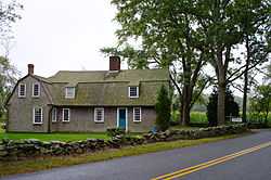
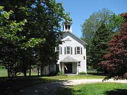
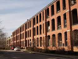
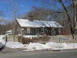
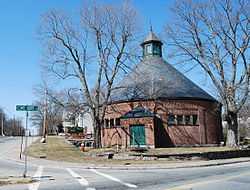
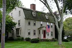
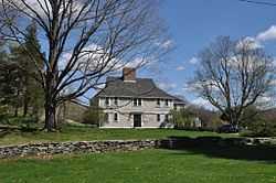
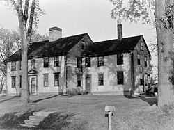
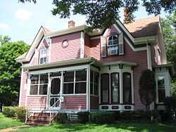
Elisha Allen House |
|
01983-06-06-0000June 6, 1983
(#83000616) |
108 Homestead Ave.
41°52′51″N 71°16′09″W / 41.8808°N 71.2692°W / 41.8808; -71.2692 (Elisha Allen House) |
Rehoboth |
|
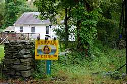
| 2 |
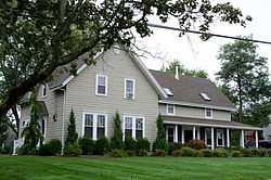
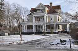
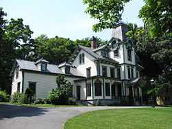
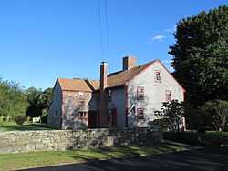
Anawan Club Clubhouse and Caretaker's House |
|
01983-06-06-0000June 6, 1983
(#83000618) |
13 Gorham St.
41°49′35″N 71°13′25″W / 41.826389°N 71.223611°W / 41.826389; -71.223611 (Anawan Club Clubhouse and Caretaker's House) |
Rehoboth |
|
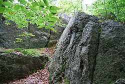
| 3 |
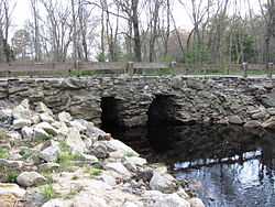
Anawan Rock |
|
01983-06-06-0000June 6, 1983
(#83000619) |
Anawan St.
41°51′54″N 71°12′52″W / 41.865°N 71.214444°W / 41.865; -71.214444 (Anawan Rock) |
Rehoboth |
|
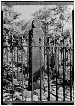
| 4 |
Angle Tree Stone |
|
01976-01-01-0000January 1, 1976
(#76000228) |
West of North Attleborough off High St.
41°59′06″N 71°21′54″W / 41.985°N 71.365°W / 41.985; -71.365 (Angle Tree Stone) |
North Attleborough |
Extends into Plainville in Norfolk County.
|
| 5 |
David M. Anthony House |
|
01990-02-16-0000February 16, 1990
(#90000059) |
98 Bay Point Ave.
41°42′37″N 71°12′37″W / 41.710278°N 71.210278°W / 41.710278; -71.210278 (David M. Anthony House) |
Swansea |
|
| 6 |
Harold H. Anthony House |
|
01990-02-12-0000February 12, 1990
(#90000058) |
132 Bay Point Ave.
41°42′39″N 71°12′43″W / 41.710833°N 71.211944°W / 41.710833; -71.211944 (Harold H. Anthony House) |
Swansea |
|
| 7 |
Apponegansett Meeting House |
|
01991-03-14-0000March 14, 1991
(#91000241) |
Russells Mills Rd. east of Fresh River Valley Rd.
41°35′02″N 70°59′43″W / 41.5839°N 70.9953°W / 41.5839; -70.9953 (Apponegansett Meeting House) |
Dartmouth |
|
| 8 |
Assonet Historic District |
|
01999-09-09-0000September 9, 1999
(#99001116) |
Roughly bounded by MA 24, a private lane, Conrail railroad racks, and High St.
41°47′36″N 71°04′12″W / 41.793333°N 71.07°W / 41.793333; -71.07 (Assonet Historic District) |
Freetown |
|
| 9 |
Attleborough Falls Gasholder Building |
|
01996-08-01-0000August 1, 1996
(#96000848) |
380 Elm St.
41°58′28″N 71°19′11″W / 41.974444°N 71.319722°W / 41.974444; -71.319722 (Attleborough Falls Gasholder Building) |
North Attleborough |
|
| 10 |
Attleborough Falls Historic District |
|
02004-01-06-0000January 6, 2004
(#03001372) |
Mt. Hope St., just west of Reservoir St. to the Ten Mile River, Towne St. from Mt. Hope St. to the Ten Mile River
41°35′02″N 70°59′43″W / 41.583889°N 70.995278°W / 41.583889; -70.995278 (Attleborough Falls Historic District) |
North Attleborough |
|
| 11 |
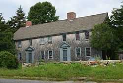
Baker House |
|
01983-06-06-0000June 6, 1983
(#83000622) |
191 Hornbine St.
41°47′31″N 71°11′36″W / 41.791944°N 71.193333°W / 41.791944; -71.193333 (Baker House) |
Rehoboth |
|
| 12 |
Bark Street School |
|
01990-02-16-0000February 16, 1990
(#90000062) |
Stevens Rd. at Bark St.
41°44′58″N 71°09′50″W / 41.749444°N 71.163889°W / 41.749444; -71.163889 (Bark Street School) |
Swansea |
|
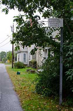
| 13 |
Barneyville Historic District |
|
01990-02-16-0000February 16, 1990
(#90000052) |
Old Providence and Barneyville Rds.
41°46′17″N 71°17′00″W / 41.771389°N 71.283333°W / 41.771389; -71.283333 (Barneyville Historic District) |
Swansea |
|
| 14 |
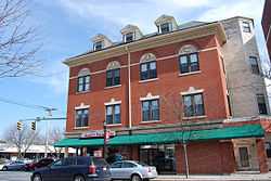
H.F. Barrows Manufacturing Company Building |
|
02001-08-30-0000August 30, 2001
(#01000907) |
102 S. Washington St.
41°58′45″N 71°20′00″W / 41.979167°N 71.333333°W / 41.979167; -71.333333 (H.F. Barrows Manufacturing Company Building) |
North Attleborough |
|
| 15 |
Bay Road |
|
01972-05-05-0000May 5, 1972
(#72000118) |
416-535 Bay Rd. (Foundry St. to the Norton town line)
42°00′36″N 71°07′17″W / 42.01°N 71.121389°W / 42.01; -71.121389 (Bay Road) |
Easton |
|
| 16 |
Bend of the Lane |
|
01990-02-12-0000February 12, 1990
(#90000057) |
181 Cedar Ave.
41°44′28″N 71°13′12″W / 41.7411°N 71.22°W / 41.7411; -71.22 (Bend of the Lane) |
Swansea |
|
| 17 |
Blackinton Houses and Park |
|
01979-04-20-0000April 20, 1979
(#79000326) |
N. Main St.
41°57′01″N 71°17′31″W / 41.950278°N 71.291944°W / 41.950278; -71.291944 (Blackinton Houses and Park) |
Attleboro |
|
| 18 |
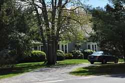
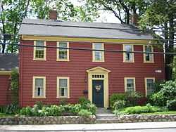
Abiah Bliss House |
|
01983-06-06-0000June 6, 1983
(#83000625) |
154 Agricultural Ave.
41°53′20″N 71°16′29″W / 41.888889°N 71.274722°W / 41.888889; -71.274722 (Abiah Bliss House) |
Rehoboth |
|
| 19 |
Daniel Bliss Homestead |
|
01983-06-06-0000June 6, 1983
(#83000626) |
76 Homestead Ave.
41°52′43″N 71°15′53″W / 41.878611°N 71.264722°W / 41.878611; -71.264722 (Daniel Bliss Homestead) |
Rehoboth |
|
| 20 |
Borderland Historic District |
|
01997-06-16-0000June 16, 1997
(#97000497) |
Massapoag Avenue
42°04′02″N 71°09′24″W / 42.0671°N 71.1567°W / 42.0671; -71.1567 (Borderland Historic District) |
Easton |
Coextensive with Borderland State Park, extending into Sharon in Norfolk County.
|
| 21 |
Nathan Bowen House |
|
01983-06-06-0000June 6, 1983
(#83000633) |
26 Kelton St.
41°49′50″N 71°13′47″W / 41.8306°N 71.2297°W / 41.8306; -71.2297 (Nathan Bowen House) |
Rehoboth |
|
| 22 |
Bramble Hill |
|
01983-06-06-0000June 6, 1983
(#83000634) |
32 Moulton St.
41°51′23″N 71°14′34″W / 41.8564°N 71.2428°W / 41.8564; -71.2428 (Bramble Hill) |
Rehoboth |
|
| 23 |
Briggs Tavern |
|
01983-06-06-0000June 6, 1983
(#83000636) |
2 Anawan St.
41°54′13″N 71°13′09″W / 41.903611°N 71.219167°W / 41.903611; -71.219167 (Briggs Tavern) |
Rehoboth |
|
| 24 |
Brown House |
|
01983-06-06-0000June 6, 1983
(#83000639) |
384 Tremont St.
41°54′07″N 71°15′48″W / 41.901944°N 71.263333°W / 41.901944; -71.263333 (Brown House) |
Rehoboth |
|
| 25 |
John Brown IV House |
|
01990-02-16-0000February 16, 1990
(#90000064) |
703 Pearse Rd.
41°43′40″N 71°13′41″W / 41.727778°N 71.228056°W / 41.727778; -71.228056 (John Brown IV House) |
Swansea |
|
| 26 |
Deacon John Buffington House |
|
01990-02-16-0000February 16, 1990
(#90000056) |
262 Cedar Ave.
41°44′25″N 71°13′05″W / 41.740278°N 71.218056°W / 41.740278; -71.218056 (Deacon John Buffington House) |
Swansea |
|
| 27 |
Cadman-White-Handy House |
|
01992-07-16-0000July 16, 1992
(#92000831) |
202 Hixbridge Rd.
41°34′18″N 71°04′36″W / 41.571667°N 71.076667°W / 41.571667; -71.076667 (Cadman-White-Handy House) |
Westport |
|
| 28 |
Capron House |
|
01978-07-21-0000July 21, 1978
(#78000426) |
42 North Ave.
41°57′19″N 71°17′50″W / 41.955278°N 71.297222°W / 41.955278; -71.297222 (Capron House) |
Attleboro |
|
| 29 |
Carpenter Bridge |
|
01983-06-06-0000June 6, 1983
(#83000641) |
Carpenter St.
41°49′41″N 71°15′20″W / 41.828056°N 71.255556°W / 41.828056; -71.255556 (Carpenter Bridge) |
Rehoboth |
|
| 30 |
Carpenter Homestead |
|
01993-09-17-0000September 17, 1993
(#93000902) |
80 Walnut St.
41°51′02″N 71°18′15″W / 41.850556°N 71.304167°W / 41.850556; -71.304167 (Carpenter Homestead) |
Seekonk |
|
| 31 |
Carpenter House |
|
01983-06-06-0000June 6, 1983
(#83000642) |
89 Carpenter St.
41°51′17″N 71°15′17″W / 41.854722°N 71.254722°W / 41.854722; -71.254722 (Carpenter House) |
Rehoboth |
|
| 32 |
Christopher Carpenter House |
|
01983-06-06-0000June 6, 1983
(#83000643) |
60 Carpenter St.
41°51′21″N 71°15′06″W / 41.855833°N 71.251667°W / 41.855833; -71.251667 (Christopher Carpenter House) |
Rehoboth |
|
| 33 |
Col. Thomas Carpenter III House |
|
01983-06-06-0000June 6, 1983
(#83000644) |
77 Bay State Rd.
41°50′40″N 71°14′36″W / 41.844444°N 71.243333°W / 41.844444; -71.243333 (Col. Thomas Carpenter III House) |
Rehoboth |
|
| 34 |
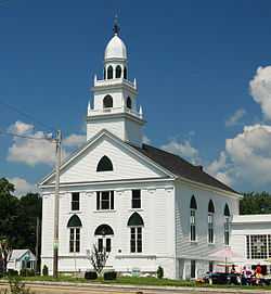
Church of Christ, Swansea |
|
01990-02-16-0000February 16, 1990
(#90000075) |
G.A.R. Highway/U.S. Route 6 at Maple Ave.
41°45′03″N 71°13′31″W / 41.750833°N 71.225278°W / 41.750833; -71.225278 (Church of Christ, Swansea) |
Swansea |
|
| 35 |
Pitt Clarke House |
|
01976-07-13-0000July 13, 1976
(#76000230) |
42 Mansfield Ave.
41°58′13″N 71°11′40″W / 41.970278°N 71.194444°W / 41.970278; -71.194444 (Pitt Clarke House) |
Norton |
|
| 36 |
The Codding Farm |
|
02009-04-22-0000April 22, 2009
(#09000236) |
217 High St.
41°59′09″N 71°20′33″W / 41.985697°N 71.342456°W / 41.985697; -71.342456 (The Codding Farm) |
North Attleborough |
|
| 37 |
Benjamin Cole House |
|
01990-02-16-0000February 16, 1990
(#90000066) |
412 Old Warren Rd.
41°44′31″N 71°13′57″W / 41.7419°N 71.2325°W / 41.7419; -71.2325 (Benjamin Cole House) |
Swansea |
|
| 38 |
Colony Historic District |
|
01990-02-16-0000February 16, 1990
(#90000079) |
Gardner's Neck and Mattapoisett Rds. at Mt. Hope Bay
41°42′35″N 71°12′23″W / 41.709722°N 71.206389°W / 41.709722; -71.206389 (Colony Historic District) |
Swansea |
|
| 39 |
Commonwealth Avenue Historic District |
|
02003-12-12-0000December 12, 2003
(#03001261) |
Northern side of Commonwealth Ave. from Stanley St. to beyond Robinson St.
41°58′11″N 71°18′37″W / 41.969722°N 71.310278°W / 41.969722; -71.310278 (Commonwealth Avenue Historic District) |
North Attleborough |
|
| 40 |
Coram Shipyard Historic District |
|
01998-01-05-0000January 5, 1998
(#97000625) |
2120, 2125, and 2130 Water St.
41°48′46″N 71°07′02″W / 41.8128°N 71.1172°W / 41.8128; -71.1172 (Coram Shipyard Historic District) |
Dighton |
|
| 41 |
Cottage-Freeman Historic District |
|
02003-12-12-0000December 12, 2003
(#03001263) |
Cottage St. and Freeman St., from Commonwealth Ave. to the Ten Mile River and Park Ln.
41°58′03″N 71°18′38″W / 41.9675°N 71.310556°W / 41.9675; -71.310556 (Cottage-Freeman Historic District) |
North Attleborough |
|
| 42 |
Paul Cuffe Farm |
|
01974-05-30-0000May 30, 1974
(#74000394) |
1504 Drift Rd.
41°32′57″N 71°04′06″W / 41.5492°N 71.0683°W / 41.5492; -71.0683 (Paul Cuffe Farm) |
Westport |
National Historic Landmark
|
| 43 |
Caleb Cushing House and Farm |
|
01983-06-06-0000June 6, 1983
(#83000660) |
186 Pine St.
41°51′04″N 71°17′17″W / 41.851111°N 71.288056°W / 41.851111; -71.288056 (Caleb Cushing House and Farm) |
Rehoboth |
|
| 44 |
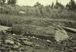
Dighton Rock |
|
01980-07-01-0000July 1, 1980
(#80000438) |
Across the Taunton River from Dighton in Dighton Rock State Park
41°48′46″N 71°06′38″W / 41.812778°N 71.110556°W / 41.812778; -71.110556 (Dighton Rock) |
Berkley |
|
| 45 |
Dighton Wharves Historic District |
|
01997-07-17-0000July 17, 1997
(#97000725) |
2298-2328 Pleasant St.
41°48′31″N 71°07′16″W / 41.8086°N 71.1211°W / 41.8086; -71.1211 (Dighton Wharves Historic District) |
Dighton |
|
| 46 |
Nathaniel Drown House |
|
01983-06-06-0000June 6, 1983
(#83000663) |
116 Summer St.
41°50′29″N 71°15′32″W / 41.841389°N 71.258889°W / 41.841389; -71.258889 (Nathaniel Drown House) |
Rehoboth |
|
| 47 |
East Attleborough Academy |
|
01985-04-04-0000April 4, 1985
(#85000694) |
28 Sanford St.
41°56′46″N 71°17′06″W / 41.9461°N 71.285°W / 41.9461; -71.285 (East Attleborough Academy) |
Attleboro |
|
| 48 |
East Freetown Historic District |
|
01999-09-09-0000September 9, 1999
(#99001115) |
Roughly along Howland, Gurney, and Washburn County Rds.
41°46′22″N 70°57′55″W / 41.7728°N 70.9653°W / 41.7728; -70.9653 (East Freetown Historic District) |
Freetown |
|
| 49 |
Elm Cottage/Blanding Farm |
|
01983-06-06-0000June 6, 1983
(#83000666) |
103 Broad St.
41°50′16″N 71°17′29″W / 41.8378°N 71.2914°W / 41.8378; -71.2914 (Elm Cottage/Blanding Farm) |
Rehoboth |
|
| 50 |
Fairhaven High School and Academy |
|
01981-01-22-0000January 22, 1981
(#81000121) |
Huttleston Ave.
41°38′35″N 70°54′23″W / 41.6431°N 70.9064°W / 41.6431; -70.9064 (Fairhaven High School and Academy) |
Fairhaven |
|
| 51 |
Fairhaven Town Hall |
|
01981-01-22-0000January 22, 1981
(#81000122) |
Center St.
41°38′11″N 70°54′14″W / 41.6364°N 70.9039°W / 41.6364; -70.9039 (Fairhaven Town Hall) |
Fairhaven |
|
| 52 |
Fire Barn |
|
01982-01-28-0000January 28, 1982
(#82004960) |
Commonwealth Ave.
41°58′17″N 71°18′52″W / 41.9714°N 71.3144°W / 41.9714; -71.3144 (Fire Barn) |
North Attleborough |
|
| 53 |
First Baptist Church and Society |
|
01990-02-16-0000February 16, 1990
(#90000060) |
Baptist St.
41°46′16″N 71°16′09″W / 41.7711°N 71.2692°W / 41.7711; -71.2692 (First Baptist Church and Society) |
Swansea |
|
| 54 |
First Parsonage for Second East Parish Church |
Upload image |
01980-04-02-0000April 2, 1980
(#80000429) |
41 S. Main St.
41°56′36″N 71°17′07″W / 41.9433°N 71.2853°W / 41.9433; -71.2853 (First Parsonage for Second East Parish Church) |
Attleboro |
Demolished.[5]
|
| 55 |
Fisher-Richardson House |
|
01998-02-11-0000February 11, 1998
(#98000096) |
354 Willow St.
42°00′37″N 71°13′42″W / 42.0103°N 71.2283°W / 42.0103; -71.2283 (Fisher-Richardson House) |
Mansfield |
|
| 56 |
Fort Phoenix |
|
01972-11-09-0000November 9, 1972
(#72000120) |
South of U.S. Route 6 in Fort Phoenix Park
41°37′26″N 70°54′11″W / 41.6239°N 70.9031°W / 41.6239; -70.9031 (Fort Phoenix) |
Fairhaven |
|
| 57 |
Furnace Village Historic District |
|
01983-10-06-0000October 6, 1983
(#83003938) |
MA 106/123
42°01′24″N 71°07′57″W / 42.0233°N 71.1325°W / 42.0233; -71.1325 (Furnace Village Historic District) |
Easton |
|
| 58 |
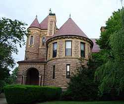
Francis L. Gardner House |
|
01990-02-16-0000February 16, 1990
(#90000077) |
1129 Gardner's Neck Rd.
41°43′15″N 71°12′09″W / 41.7208°N 71.2025°W / 41.7208; -71.2025 (Francis L. Gardner House) |
Swansea |
|
| 59 |
Joseph Gardner House |
|
01990-02-16-0000February 16, 1990
(#90000076) |
1205 Gardner's Neck Rd.
41°43′07″N 71°12′15″W / 41.7186°N 71.2042°W / 41.7186; -71.2042 (Joseph Gardner House) |
Swansea |
|
| 60 |
Preserved Gardner House |
|
01990-02-16-0000February 16, 1990
(#90000061) |
90 Milford Rd.
41°45′03″N 71°11′58″W / 41.7508°N 71.1994°W / 41.7508; -71.1994 (Preserved Gardner House) |
Swansea |
|
| 61 |
Samuel Gardner House |
|
01990-02-16-0000February 16, 1990
(#90000068) |
1035 Gardner's Neck Rd.
41°43′22″N 71°12′08″W / 41.722778°N 71.202222°W / 41.722778; -71.202222 (Samuel Gardner House) |
Swansea |
|
| 62 |
Goff Farm |
|
01983-06-06-0000June 6, 1983
(#83000672) |
157 Perryville Rd.
41°52′02″N 71°15′30″W / 41.867222°N 71.258333°W / 41.867222; -71.258333 (Goff Farm) |
Rehoboth |
Listed at 158 Perryville Rd.
|
| 63 |
Goff Homestead |
|
01983-06-06-0000June 6, 1983
(#83000673) |
40 Maple Lane
41°50′50″N 71°13′27″W / 41.847222°N 71.224167°W / 41.847222; -71.224167 (Goff Homestead) |
Rehoboth |
|
| 64 |
H. H. Richardson Historic District of North Easton |
|
01987-12-23-0000December 23, 1987
(#87002598) |
Main St., Elm St., and railway right-of-way off Oliver St.
42°04′12″N 71°06′02″W / 42.07°N 71.1006°W / 42.07; -71.1006 (H. H. Richardson Historic District of North Easton) |
Easton |
Five buildings designed by H. H. Richardson; contained within the North Easton Historic District
|
| 65 |
Head of the River Historic District |
|
02009-12-02-0000December 2, 2009
(#09000965) |
2-28 Main St.
41°40′54″N 70°55′09″W / 41.681736°N 70.919186°W / 41.681736; -70.919186 (Head of the River Historic District) |
Acushnet |
Extends into New Bedford.
|
| 66 |
Hebronville Mill Historic District |
|
01984-05-17-0000May 17, 1984
(#84002126) |
Knight Ave., Read St., and Phillip St.
41°54′18″N 71°19′12″W / 41.905°N 71.32°W / 41.905; -71.32 (Hebronville Mill Historic District) |
Attleboro |
|
| 67 |
High, Church and Gould Streets Historic District |
|
01999-11-12-0000November 12, 1999
(#99001305) |
56-60-122 High St., 29-117 Church St., and 9-17 Gould St.
41°59′00″N 71°20′12″W / 41.983267°N 71.336642°W / 41.983267; -71.336642 (High, Church and Gould Streets Historic District) |
North Attleborough |
|
| 68 |
Hill School |
|
01980-04-11-0000April 11, 1980
(#80000432) |
4 Middle St.
41°35′13″N 70°56′25″W / 41.5869°N 70.9403°W / 41.5869; -70.9403 (Hill School) |
Dartmouth |
|
| 69 |
Hixville Village Historic District |
|
01991-06-17-0000June 17, 1991
(#91000698) |
Junction of Old Fall River, Hixville, and N. Hixville Rds.
41°40′56″N 71°01′56″W / 41.6822°N 71.0322°W / 41.6822; -71.0322 (Hixville Village Historic District) |
Dartmouth |
|
| 70 |
Hooper House |
|
01990-08-08-0000August 8, 1990
(#90000074) |
306 Hortonville Rd.
41°45′30″N 71°11′49″W / 41.758333°N 71.196944°W / 41.758333; -71.196944 (Hooper House) |
Swansea |
|
| 71 |
Hornbine Baptist Church |
|
01983-06-06-0000June 6, 1983
(#83000678) |
141 Hornbine Rd.
41°47′55″N 71°12′03″W / 41.798611°N 71.200833°W / 41.798611; -71.200833 (Hornbine Baptist Church) |
Rehoboth |
|
| 72 |
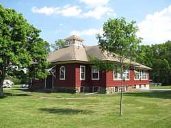
Hornbine School |
|
01983-06-06-0000June 6, 1983
(#83000679) |
144 Hornbine Road
41°47′53″N 71°12′07″W / 41.798056°N 71.201944°W / 41.798056; -71.201944 (Hornbine School) |
Rehoboth |
|
| 73 |
Welcome Horton Farm |
|
01983-06-06-0000June 6, 1983
(#83000680) |
122 Martin St.
41°47′58″N 71°14′14″W / 41.799444°N 71.237222°W / 41.799444; -71.237222 (Welcome Horton Farm) |
Rehoboth |
|
| 74 |
Hortonville Historic District |
|
01990-02-16-0000February 16, 1990
(#90000051) |
Locust St. from Oak St. to Hortonville Rd.
41°46′27″N 71°12′36″W / 41.774167°N 71.21°W / 41.774167; -71.21 (Hortonville Historic District) |
Swansea |
|
| 75 |
House at 197 Hornbine Road |
|
01983-06-06-0000June 6, 1983
(#83000681) |
197 Hornbine Rd.
41°47′28″N 71°12′02″W / 41.791111°N 71.200556°W / 41.791111; -71.200556 (House at 197 Hornbine Road) |
Rehoboth |
|
| 76 |
House at 30 Kelton Street |
|
01983-06-06-0000June 6, 1983
(#83000682) |
30 Kelton St.
41°49′50″N 71°13′51″W / 41.830556°N 71.230833°W / 41.830556; -71.230833 (House at 30 Kelton Street) |
Rehoboth |
|
| 77 |
Ingalls-Wheeler-Horton Homstead Site |
|
01983-06-06-0000June 6, 1983
(#83000684) |
214 Chestnut St.
41°49′02″N 71°14′49″W / 41.817222°N 71.246944°W / 41.817222; -71.246944 (Ingalls-Wheeler-Horton Homstead Site) |
Rehoboth |
|
| 78 |
J. V. Johnson House |
|
01990-08-08-0000August 8, 1990
(#90000069) |
36 Riverview Ave.
41°42′55″N 71°12′10″W / 41.715278°N 71.202778°W / 41.715278; -71.202778 (J. V. Johnson House) |
Swansea |
|
| 79 |
Kingsley House |
|
01983-06-06-0000June 6, 1983
(#83000688) |
108 Davis St.
41°46′44″N 71°15′39″W / 41.778889°N 71.260833°W / 41.778889; -71.260833 (Kingsley House) |
Rehoboth |
Listed at 96 Davis Street.
|
| 80 |
Seth Knapp, Jr. House |
|
01983-06-06-0000June 6, 1983
(#83000689) |
82 Water St.
41°48′46″N 71°16′52″W / 41.812778°N 71.281111°W / 41.812778; -71.281111 (Seth Knapp, Jr. House) |
Rehoboth |
|
| 81 |
Long Plain Friends Meetinghouse |
|
01986-06-26-0000June 26, 1986
(#86001374) |
1341 N. Main St.
41°44′50″N 70°54′07″W / 41.7472°N 70.9019°W / 41.7472; -70.9019 (Long Plain Friends Meetinghouse) |
Acushnet |
|
| 82 |
Long Plain School |
|
02012-07-17-0000July 17, 2012
(#12000413) |
1203 Main St.
41°44′15″N 70°53′47″W / 41.7375°N 70.8965°W / 41.7375; -70.8965 (Long Plain School) |
Acushnet |
now known as the Long Plain Museum
|
| 83 |
Luther House |
|
01990-08-08-0000August 8, 1990
(#90000073) |
177 Market St.
41°45′52″N 71°16′09″W / 41.764444°N 71.269167°W / 41.764444; -71.269167 (Luther House) |
Swansea |
|
| 84 |
Luther Store |
|
01978-05-22-0000May 22, 1978
(#78000438) |
West of Swansea at 160 Old Warren Rd.
41°44′41″N 71°13′25″W / 41.744722°N 71.223611°W / 41.744722; -71.223611 (Luther Store) |
Swansea |
|
| 85 |
Luther's Corner |
|
01990-02-16-0000February 16, 1990
(#90000054) |
Old Warren and Pierce Rds.
41°44′42″N 71°13′27″W / 41.745°N 71.224167°W / 41.745; -71.224167 (Luther's Corner) |
Swansea |
|
| 86 |
William Luther House |
|
01990-02-16-0000February 16, 1990
(#90000067) |
79 Old Warren Rd.
41°44′46″N 71°13′16″W / 41.746111°N 71.221111°W / 41.746111; -71.221111 (William Luther House) |
Swansea |
|
| 87 |
D. E. Makepeace Company |
|
01985-07-18-0000July 18, 1985
(#85001577) |
46 Pine St.
41°56′32″N 71°16′52″W / 41.942222°N 71.281111°W / 41.942222; -71.281111 (D. E. Makepeace Company) |
Attleboro |
|
| 88 |
Martin Farm |
|
01983-06-06-0000June 6, 1983
(#83000691) |
121 Martin St.
41°47′52″N 71°14′14″W / 41.797778°N 71.237222°W / 41.797778; -71.237222 (Martin Farm) |
Rehoboth |
|
| 89 |
Martin House |
|
01974-05-02-0000May 2, 1974
(#74000365) |
940 County St.
41°48′50″N 71°17′54″W / 41.813889°N 71.298333°W / 41.813889; -71.298333 (Martin House) |
Seekonk |
|
| 90 |
Martin House and Farm |
|
01978-10-02-0000October 2, 1978
(#78000437) |
22 Stoney Hill Rd.
41°45′50″N 71°15′36″W / 41.763889°N 71.26°W / 41.763889; -71.26 (Martin House and Farm) |
Swansea |
|
| 91 |
William P. Mason House |
|
01990-08-08-0000August 8, 1990
(#90000121) |
5 Mason St.
41°46′21″N 71°16′24″W / 41.7725°N 71.273333°W / 41.7725; -71.273333 (William P. Mason House) |
Swansea |
|
| 92 |
Millicent Library |
|
01986-05-15-0000May 15, 1986
(#86001051) |
45 Center St.
41°38′41″N 70°54′15″W / 41.6447°N 70.9042°W / 41.6447; -70.9042 (Millicent Library) |
Fairhaven |
|
| 93 |
North Attleborough Town Center Historic District |
|
01985-12-20-0000December 20, 1985
(#85003168) |
Roughly N. and S. Washington St. between Fisher and Bank Sts.
41°58′59″N 71°20′00″W / 41.983056°N 71.333333°W / 41.983056; -71.333333 (North Attleborough Town Center Historic District) |
North Attleborough |
|
| 94 |
North Easton Historic District |
|
01972-11-03-0000November 3, 1972
(#72000119) |
Section of town north of and including both sides of Main-Lincoln St.
42°04′13″N 71°05′59″W / 42.070278°N 71.099722°W / 42.070278; -71.099722 (North Easton Historic District) |
Easton |
|
| 95 |
North Easton Railroad Station |
|
01972-04-11-0000April 11, 1972
(#72000125) |
80 Mechanic St.
42°04′11″N 71°06′14″W / 42.069722°N 71.103889°W / 42.069722; -71.103889 (North Easton Railroad Station) |
Easton |
|
| 96 |
Northbound and Southbound Stations |
|
01989-01-05-0000January 5, 1989
(#88003128) |
1 and 3 Mill St.
41°56′31″N 71°17′06″W / 41.941944°N 71.285°W / 41.941944; -71.285 (Northbound and Southbound Stations) |
Attleboro |
|
| 97 |
Norton Center Historic District |
|
01977-12-23-0000December 23, 1977
(#77000170) |
MA 123
41°58′03″N 71°11′10″W / 41.9675°N 71.186111°W / 41.9675; -71.186111 (Norton Center Historic District) |
Norton |
|
| 98 |
Norton House |
|
01990-02-16-0000February 16, 1990
(#90000078) |
61 Old Providence Rd.
41°46′21″N 71°16′27″W / 41.7725°N 71.274167°W / 41.7725; -71.274167 (Norton House) |
Swansea |
|
| 99 |
Old Bay Road |
|
01974-11-08-0000November 8, 1974
(#74000362) |
From Easton town line to Taunton town line
41°58′54″N 71°07′35″W / 41.981667°N 71.126389°W / 41.981667; -71.126389 (Old Bay Road) |
Norton |
|
| 100 |
Old Town Historic District |
|
01991-05-30-0000May 30, 1991
(#91000599) |
Near the junction of Old Post Road and Mt. Hope St.
41°56′40″N 71°20′24″W / 41.9444°N 71.34°W / 41.9444; -71.34 (Old Town Historic District) |
North Attleborough |
|
| 101 |
Padanaram Village Historic District |
|
01985-09-05-0000September 5, 1985
(#85002010) |
Elm, Water, Middle, High, Pleasant, Prospect, Hill, School, Fremont, and Bridge Sts.
41°35′08″N 70°56′30″W / 41.5856°N 70.9417°W / 41.5856; -70.9417 (Padanaram Village Historic District) |
Dartmouth |
|
| 102 |
Peck-Bowen House |
|
01983-06-06-0000June 6, 1983
(#83000700) |
330 Fairview Ave.
41°52′20″N 71°13′42″W / 41.8722°N 71.2283°W / 41.8722; -71.2283 (Peck-Bowen House) |
Rehoboth |
|
| 103 |
James Perry House |
|
01983-06-06-0000June 6, 1983
(#83000701) |
121 Perryville Rd.
41°51′41″N 71°15′26″W / 41.861389°N 71.257222°W / 41.861389; -71.257222 (James Perry House) |
Rehoboth |
|
| 104 |
Capt. Mial Pierce Farm |
|
01983-06-06-0000June 6, 1983
(#83000703) |
177 Hornbine Rd.
41°47′41″N 71°11′56″W / 41.794722°N 71.198889°W / 41.794722; -71.198889 (Capt. Mial Pierce Farm) |
Rehoboth |
|
| 105 |
Rehoboth Village Historic District |
|
01983-06-06-0000June 6, 1983
(#83000707) |
Bay State Rd. and Locust Ave.
41°50′26″N 71°15′09″W / 41.840556°N 71.2525°W / 41.840556; -71.2525 (Rehoboth Village Historic District) |
Rehoboth |
|
| 106 |
Capt. Joel Robinson House |
|
01978-11-20-0000November 20, 1978
(#78000428) |
111 Rocklawn Ave.
41°56′17″N 71°19′57″W / 41.938056°N 71.3325°W / 41.938056; -71.3325 (Capt. Joel Robinson House) |
Attleboro |
|
| 107 |
Russells Mills Village Historic District |
|
01985-09-05-0000September 5, 1985
(#85002011) |
Russells Mills, Rock O' Dundee, Slades Corner, Horseneck, and Fisher Rds.
41°34′23″N 71°00′18″W / 41.5731°N 71.005°W / 41.5731; -71.005 (Russells Mills Village Historic District) |
Dartmouth |
|
| 108 |
Herbert A. Sadler House |
|
01982-10-21-0000October 21, 1982
(#82000489) |
574 Newport Ave.
41°55′20″N 71°21′16″W / 41.9222°N 71.3544°W / 41.9222; -71.3544 (Herbert A. Sadler House) |
Attleboro |
|
| 109 |
Ezekiel Sawin House |
|
01979-06-15-0000June 15, 1979
(#79000327) |
44 William St.
41°38′13″N 70°54′17″W / 41.636944°N 70.904722°W / 41.636944; -70.904722 (Ezekiel Sawin House) |
Fairhaven |
|
| 110 |
Short's Tavern |
|
01990-02-16-0000February 16, 1990
(#90000072) |
282 Market St.
41°45′42″N 71°16′09″W / 41.761667°N 71.269167°W / 41.761667; -71.269167 (Short's Tavern) |
Swansea |
|
| 111 |
Simcock House |
|
01990-02-16-0000February 16, 1990
(#90000063) |
1074 Sharps Lot Rd.
41°46′49″N 71°10′19″W / 41.780278°N 71.171944°W / 41.780278; -71.171944 (Simcock House) |
Swansea |
|
| 112 |
Smuggler's House |
|
01990-02-16-0000February 16, 1990
(#90000065) |
361 Pearse Rd.
41°44′05″N 71°13′26″W / 41.734722°N 71.223889°W / 41.734722; -71.223889 (Smuggler's House) |
Swansea |
|
| 113 |
Soldiers' Memorial Library |
|
01995-06-02-0000June 2, 1995
(#95000681) |
Junction of Park Row and Union St.
42°01′24″N 71°13′02″W / 42.023333°N 71.217222°W / 42.023333; -71.217222 (Soldiers' Memorial Library) |
Mansfield |
|
| 114 |
South Swansea Union Church |
|
01990-02-16-0000February 16, 1990
(#90000055) |
Gardner's Neck Rd.
41°43′27″N 71°12′05″W / 41.724167°N 71.201389°W / 41.724167; -71.201389 (South Swansea Union Church) |
Swansea |
|
| 115 |
South Washington Street Historic District |
|
01995-10-12-0000October 12, 1995
(#95001173) |
145-327 S. Washington St. and 1-6 Hunting St.
41°58′29″N 71°20′07″W / 41.9747°N 71.3353°W / 41.9747; -71.3353 (South Washington Street Historic District) |
North Attleborough |
|
| 116 |
Spring Brook Cemetery |
|
02007-12-06-0000December 6, 2007
(#07001240) |
Spring St
42°01′07″N 71°13′20″W / 42.018653°N 71.222114°W / 42.018653; -71.222114 (Spring Brook Cemetery) |
Mansfield |
|
| 117 |
Swansea Friends Meeting House and Cemetery |
|
02014-04-15-0000April 15, 2014
(#14000156) |
223 Prospect Street
41°44′19″N 71°09′25″W / 41.7387°N 71.1569°W / 41.7387; -71.1569 (Swansea Friends Meeting House and Cemetery) |
Somerset |
|
| 118 |
Swansea Village Historic District |
|
01990-02-16-0000February 16, 1990
(#90000053) |
Roughly Main St. from Gardners Neck Rd. to Stephens Rd., and Ledge Rd.
41°44′47″N 71°11′26″W / 41.746389°N 71.190556°W / 41.746389; -71.190556 (Swansea Village Historic District) |
Swansea |
|
| 119 |
Towne Street Historic District |
|
02003-11-26-0000November 26, 2003
(#03001210) |
Towne St. east of Jackson St.
41°58′21″N 71°18′44″W / 41.9725°N 71.3122°W / 41.9725; -71.3122 (Towne Street Historic District) |
North Attleborough |
|
| 120 |
Tucker Farm Historic District |
|
01988-08-25-0000August 25, 1988
(#88000705) |
1178 Tucker Rd.
41°37′46″N 70°58′55″W / 41.6294°N 70.9819°W / 41.6294; -70.9819 (Tucker Farm Historic District) |
Dartmouth |
|
| 121 |
Unitarian Memorial Church |
|
01996-11-22-0000November 22, 1996
(#96001374) |
102 Green St.
41°38′01″N 70°54′09″W / 41.6336°N 70.9025°W / 41.6336; -70.9025 (Unitarian Memorial Church) |
Fairhaven |
|
| 122 |
US Post Office-Attleboro Main |
|
01987-10-19-0000October 19, 1987
(#87001767) |
75 Park St.
41°56′38″N 71°16′54″W / 41.943889°N 71.281667°W / 41.943889; -71.281667 (US Post Office-Attleboro Main) |
Attleboro |
1916 building now used as office by county and city
|
| 123 |
Samuel Viall House |
|
01983-06-06-0000June 6, 1983
(#83000728) |
85 Carpenter St.
41°51′17″N 71°15′15″W / 41.854722°N 71.254167°W / 41.854722; -71.254167 (Samuel Viall House) |
Rehoboth |
|
| 124 |
Walkden Farm |
|
01990-02-16-0000February 16, 1990
(#90000071) |
495 Marvel St.
41°46′35″N 71°10′21″W / 41.776389°N 71.1725°W / 41.776389; -71.1725 (Walkden Farm) |
Swansea |
|
| 125 |
Westport Point Historic District |
|
01992-06-25-0000June 25, 1992
(#92000815) |
Roughly Main St. from Charles St. to the West Branch of the Westport River, including Cape Bial and Valentine Lns.
41°31′24″N 71°04′29″W / 41.523333°N 71.074722°W / 41.523333; -71.074722 (Westport Point Historic District) |
Westport |
|
| 126 |
Aaron Wheeler House |
|
01983-06-06-0000June 6, 1983
(#83000730) |
371 Fairview Ave.
41°52′28″N 71°13′24″W / 41.8744°N 71.2233°W / 41.8744; -71.2233 (Aaron Wheeler House) |
Rehoboth |
|
| 127 |
Wheeler-Ingalls House |
|
01983-07-05-0000July 5, 1983
(#83000731) |
51 Summer St.
41°50′04″N 71°14′51″W / 41.8344°N 71.2475°W / 41.8344; -71.2475 (Wheeler-Ingalls House) |
Rehoboth |
|
| 128 |
Woodcock-Hatch-Maxcy House Historic District |
|
01990-07-12-0000July 12, 1990
(#90001081) |
362 N. Washington St.
41°59′34″N 71°19′50″W / 41.9928°N 71.3306°W / 41.9928; -71.3306 (Woodcock-Hatch-Maxcy House Historic District) |
North Attleborough |
|


_-_general_view.JPG)