| [3] |
Name on the Register[4] |
Image |
Date listed[5] |
Location |
City or town |
Description |
|---|
| 1 |
Elliott and Anna Barham House |
Upload image |
02004-01-21-0000January 21, 2004
(#03001453) |
4085 West St.
36°17′02″N 92°54′58″W / 36.283889°N 92.916111°W / 36.283889; -92.916111 (Elliott and Anna Barham House) |
Zinc |
|
| 2 |
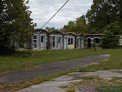
Bear Creek Motel |
|
02001-03-13-0000March 13, 2001
(#01000175) |
U.S. Highway 65
36°17′30″N 93°10′55″W / 36.291667°N 93.181944°W / 36.291667; -93.181944 (Bear Creek Motel) |
Bear Creek Springs |
|
| 3 |
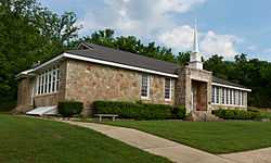
Bergman High School |
Upload image |
01992-09-10-0000September 10, 1992
(#92001203) |
County Road 48
36°18′48″N 93°01′02″W / 36.313333°N 93.017222°W / 36.313333; -93.017222 (Bergman High School) |
Bergman |
|
| 4 |
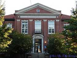
Boone County Courthouse |
|
01976-07-21-0000July 21, 1976
(#76000387) |
Courthouse Sq.
36°13′49″N 93°06′29″W / 36.230278°N 93.108056°W / 36.230278; -93.108056 (Boone County Courthouse) |
Harrison |
|
| 5 |
Boone County Jail |
Upload image |
01976-12-12-0000December 12, 1976
(#76000388) |
Central Ave. and Willow St.
36°13′45″N 93°06′30″W / 36.229167°N 93.108333°W / 36.229167; -93.108333 (Boone County Jail) |
Harrison |
|
| 6 |
Carrollton Road-Carrollton Segment |
Upload image |
02008-05-20-0000May 20, 2008
(#08000432) |
County Road 917, Terrapin Creek Rd., and Dunkard Rd. between U.S. Highway 412 and Green Hill Rd.
36°16′05″N 93°17′13″W / 36.268097°N 93.287067°W / 36.268097; -93.287067 (Carrollton Road-Carrollton Segment) |
Carrollton |
|
| 7 |
Cottonwood School #45 |
Upload image |
02002-10-04-0000October 4, 2002
(#02001078) |
Cottonwood and Dubuque Rd.
36°24′19″N 93°06′08″W / 36.405278°N 93.102222°W / 36.405278; -93.102222 (Cottonwood School #45) |
Self |
|
| 8 |
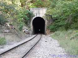
Cricket and Crest Tunnels Historic District |
|
02007-09-19-0000September 19, 2007
(#07000954) |
Under and west of Old U.S. Highway 65
36°26′39″N 93°11′29″W / 36.4442°N 93.1915°W / 36.4442; -93.1915 (Cricket and Crest Tunnels Historic District) |
Omaha |
A pair of railroad tunnels either side of Omaha.
|
| 9 |
Duncan House |
Upload image |
02005-09-28-0000September 28, 2005
(#05001065) |
610 W. Central Ave.
36°13′52″N 93°06′53″W / 36.231111°N 93.114722°W / 36.231111; -93.114722 (Duncan House) |
Harrison |
|
| 10 |
Evans-Kirby House |
Upload image |
02005-01-20-0000January 20, 2005
(#04001505) |
611 S. Pine St.
36°13′33″N 93°06′40″W / 36.225833°N 93.111111°W / 36.225833; -93.111111 (Evans-Kirby House) |
Harrison |
|
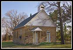
| 11 |
Everton School |
|
01992-09-10-0000September 10, 1992
(#92001205) |
Main St.
36°09′12″N 92°54′25″W / 36.153333°N 92.906944°W / 36.153333; -92.906944 (Everton School) |
Everton |
|
| 12 |
Grubb Springs School |
|
01996-03-29-0000March 29, 1996
(#96000329) |
Northeastern corner of the junction of Highways 43 and 397
36°13′12″N 93°08′59″W / 36.22°N 93.149722°W / 36.22; -93.149722 (Grubb Springs School) |
Harrison |
|
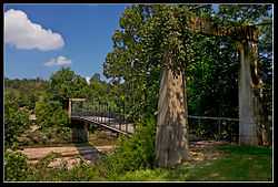
| 13 |
Haggard Ford Swinging Bridge |
|
01995-06-30-0000June 30, 1995
(#95000790) |
Over Bear Creek at Cottonwood Rd., 8 miles north of Harrison
36°20′45″N 93°07′50″W / 36.345833°N 93.130556°W / 36.345833; -93.130556 (Haggard Ford Swinging Bridge) |
Harrison |
|
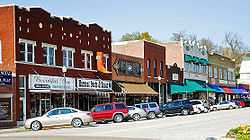
| 14 |
Harrison Courthouse Square Historic District |
|
01999-05-06-0000May 6, 1999
(#99000523) |
Roughly bounded by N. Walnut, W. Ridge, N. Willow, and W. Stephenson Sts.
36°13′51″N 93°06′28″W / 36.230833°N 93.107778°W / 36.230833; -93.107778 (Harrison Courthouse Square Historic District) |
Harrison |
|
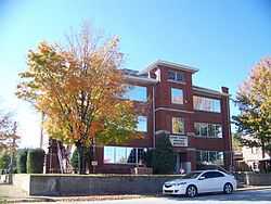
| 15 |
Harrison High School |
|
02007-01-24-0000January 24, 2007
(#06001284) |
124 S. Cherry St.
36°13′30″N 93°06′38″W / 36.225°N 93.110556°W / 36.225; -93.110556 (Harrison High School) |
Harrison |
|
| 16 |
Hotel Seville |
Upload image |
01994-05-19-0000May 19, 1994
(#94000443) |
Northwestern corner of the junction of Vine and Ridge Sts.
36°13′56″N 93°06′27″W / 36.232222°N 93.1075°W / 36.232222; -93.1075 (Hotel Seville) |
Harrison |
|
| 17 |
Missouri and North Arkansas Depot-Bellefonte |
Upload image |
01992-06-11-0000June 11, 1992
(#92000601) |
Southeastern corner of the junction of Center St. and Keeter Dr.
36°12′10″N 93°02′47″W / 36.202778°N 93.046389°W / 36.202778; -93.046389 (Missouri and North Arkansas Depot-Bellefonte) |
Bellefonte |
|
| 18 |
Twelve Oaks |
Upload image |
02010-01-20-0000January 20, 2010
(#09001237) |
7210 Highway 7 South
36°10′00″N 93°07′23″W / 36.166572°N 93.123103°W / 36.166572; -93.123103 (Twelve Oaks) |
Harrison |
|
| 19 |
Valley Springs School |
Upload image |
01992-09-10-0000September 10, 1992
(#92001204) |
1 School St.
36°09′28″N 92°59′36″W / 36.157778°N 92.993333°W / 36.157778; -92.993333 (Valley Springs School) |
Valley Springs |
|
| 20 |
Zinc Swinging Bridge-BO0162 |
Upload image |
02007-01-24-0000January 24, 2007
(#06001286) |
8039 Washington St.
36°17′05″N 92°54′55″W / 36.284722°N 92.915278°W / 36.284722; -92.915278 (Zinc Swinging Bridge-BO0162) |
Zinc |
|