National Register of Historic Places listings in Birmingham, Alabama

This is a list of the National Register of Historic Places listings in Birmingham, Alabama.
This is intended to be a complete list of the properties and districts on the National Register of Historic Places in Birmingham, Alabama, United States. Latitude and longitude coordinates are provided for many National Register properties and districts; these locations may be seen together in a Google map.[1]
There are 163 properties and districts listed on the National Register in Jefferson County, including 3 National Historic Landmarks. 141 of these sites, including all of the National Historic Landmarks, are located in Birmingham, and are listed here; the remaining 23 sites are listed separately. One district, the Red Mountain Suburbs Historic District, includes contributing properties located in the city of Birmingham and in adjacent parts of Jefferson County.
- This National Park Service list is complete through NPS recent listings posted May 1, 2015.[2]
Current listings
| [3] | Name on the Register[4] | Image | Date listed[5] | Location | City or town | Description |
|---|---|---|---|---|---|---|
| 1 | Age-Herald Building | 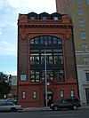 |
(#84000620) |
2107 5th Ave., N. 33°31′07″N 86°48′22″W / 33.518611°N 86.806111°W |
||
| 2 | Agee House | _Birmingham%2C_AL.JPG) |
(#86001962) |
1804 12th Ave., S. 33°29′55″N 86°47′54″W / 33.498611°N 86.798333°W |
||
| 3 | Alabama Penny Savings Bank | 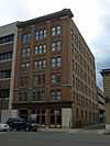 |
(#80004471) |
310 18th St., N. 33°30′54″N 86°48′37″W / 33.515°N 86.810278°W |
||
| 4 | Alabama Theatre | .jpg) |
(#79000386) |
1811 3rd Ave., N. 33°30′31″N 86°48′18″W / 33.508611°N 86.805°W |
||
| 5 | Anderson Place Historic District | 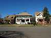 |
(#86001981) |
Roughly bounded by 14th Ave., S., 18th St., S., 16th Ave., S., and 15th St., S.; also roughly 16th Ave., S. from 15th St. to a line south from 18th St. 33°29′37″N 86°48′00″W / 33.493611°N 86.8°W |
Second set of boundaries represents a boundary increase of June 15, 1991 | |
| 6 | Arlington | 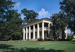 |
(#70000103) |
331 Cotton Ave., SW. 33°29′59″N 86°50′20″W / 33.499722°N 86.838889°W |
||
| 7 | Arlington Park | Upload image | (#95000097) |
800-840 1st St., W., 815-909 2nd St., W., and 100-269 Munger Ave. 33°29′58″N 86°50′12″W / 33.499444°N 86.836667°W |
||
| 8 | Automotive Historic District | 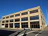 |
(#91000661) |
Roughly bounded by 1st Ave., N., 24th St., S., 5th Ave., S., and 20th St., S. 33°30′45″N 86°48′04″W / 33.5125°N 86.801111°W |
||
| 9 | Avalon | Upload image | (#85000444) |
3005-3015 Highland Ave. and 3000-3020 13th Ave. S 33°30′18″N 86°46′48″W / 33.505°N 86.78°W |
||
| 10 | Avondale Park Historic District | Upload image | (#98000106) |
Roughly bounded by 47th St., 7th Ave., 8th Court, 34th St., and State Route 4 33°31′09″N 86°46′21″W / 33.519167°N 86.7725°W |
||
| 11 | Bank of Ensley | 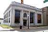 |
(#84000623) |
19th St. and Ave. E 33°30′18″N 86°53′50″W / 33.505°N 86.897222°W |
||
| 12 | Belcher-Nixon Building | Upload image | (#09000603) |
1728 20th Street Ensley 33°30′34″N 86°53′10″W / 33.509583°N 86.886111°W |
Location of the club from the song "Tuxedo Junction" | |
| 13 | Belview Heights Historic District | Upload image | (#00000713) |
Roughly along 41st, 42nd, 43rd, 44th and 45th Sts., and M and Martin Aves. 33°29′26″N 86°53′28″W / 33.490556°N 86.891111°W |
||
| 14 | Bethel Baptist Church, Parsonage, and Guardhouse |  |
(#05000455) |
3233, 3232, and 3236 29th Ave., N. 33°33′07″N 86°48′06″W / 33.551997°N 86.801739°W |
||
| 15 | Birmingham Civil Rights Historic District |  |
(#06000940) |
Roughly bounded by 9th Ave., Richard Arrington Jr. Boulevard, 1st Ave., and 14th St. 33°31′19″N 86°48′42″W / 33.521944°N 86.811667°W |
||
| 16 | Birmingham, Railway, Light and Power Building | 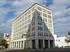 |
(#80000688) |
2100 N. 1st Ave. 33°30′55″N 86°48′15″W / 33.515278°N 86.804167°W |
||
| 17 | Birmingham–Southern College | 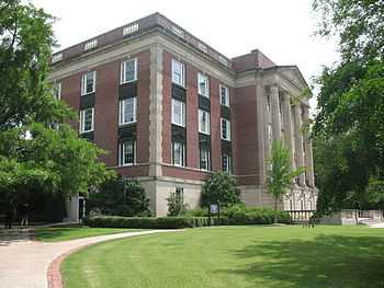 |
(#99000466) |
Arkadelphia Rd. between 8th Ave., W. and Interstates 20/59 33°30′46″N 86°51′07″W / 33.512778°N 86.851944°W |
||
| 18 | Blessed Sacrament Academy | Upload image | (#80000689) |
1525 Cotton Ave., SW. 33°29′21″N 86°51′24″W / 33.489167°N 86.856667°W |
||
| 19 | Bottega Favorita | _Birmingham%2C_AL.JPG) |
(#86001952) |
2240-2244 Highland Ave. 33°30′04″N 86°47′24″W / 33.501111°N 86.79°W |
||
| 20 | Bradshaw House | 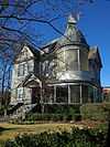 |
(#80000690) |
2154 Highland Ave. 33°30′00″N 86°47′30″W / 33.5°N 86.791667°W |
Built in 1892. | |
| 21 | Dr. A.M. Brown House | Upload image | (#74000413) |
319 N. 4th Terrace 33°30′34″N 86°49′51″W / 33.509444°N 86.830833°W |
||
| 22 | Caldwell-Milner Building | 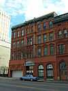 |
(#79000387) |
2015 1st Ave., N. 33°30′52″N 86°48′18″W / 33.514444°N 86.805°W |
||
| 23 | Center Street Historic District | Upload image | (#07001027) |
940-1145 Center St., 2-9th Ct., W., 4-10th Ave., N., 2-4 10th Ct., N., 16-24 11th Ave., N., and 1-2 11th Ct., N. 33°31′17″N 86°50′10″W / 33.521389°N 86.836111°W |
||
| 24 | Chestnut Hill Historic District | Upload image | (#87000940) |
Roughly bounded by Highland Ave. and 31st St. 33°30′37″N 86°46′48″W / 33.510278°N 86.78°W |
||
| 25 | Claridge Manor Apartments | Upload image | (#84000625) |
1100 27th St., S. 33°30′15″N 86°47′09″W / 33.504167°N 86.785833°W |
||
| 26 | Continental Gin Company | Upload image | (#80000691) |
4500 5th Ave., S. 33°31′40″N 86°45′51″W / 33.527778°N 86.764167°W |
||
| 27 | Country Club Historic District | Upload image | (#03001133) |
Roughly bounded by Highland Ave, 33rd St., 34th St., Pawnee Ave., and 29th St. 33°30′27″N 86°46′43″W / 33.5075°N 86.778611°W |
||
| 28 | Crittenden Building | 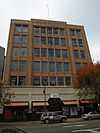 |
(#81000126) |
1914 3rd Ave., N. 33°30′58″N 86°48′29″W / 33.516111°N 86.808056°W |
||
| 29 | Cullom Street-Twelfth Street South Historic District | 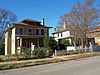 |
(#86001890) |
Roughly bounded by 11th Ave., 12th St., S, Cullom St., and 13th St., S. 33°29′33″N 86°48′26″W / 33.4925°N 86.807222°W |
||
| 30 | Downtown Birmingham Historic District | 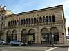 |
(#82002039) |
Roughly bounded by 3rd Ave., 24th St., 1st Ave., and 20th St.; also 312-322 21st St., N. and 1923 3rd Ave.; also roughly along 23rd St. and 3rd Ave., bounded by 5th Ave., 22nd St., and 2nd Ave.; also Portions of 1st, 2nd, 3rd, 4th , 5th, 20th, 22nd, 23rd, 24th & 25th Sts., N., Richard Arrington Jr. Blvd. 33°31′00″N 86°48′16″W / 33.516667°N 86.804444°W |
Second through fourth sets of boundaries represent boundary increases of February 21, 1985, February 20, 1998, and December 30, 2014 respectively | |
| 31 | Downtown Birmingham Retail and Theatre Historic District | 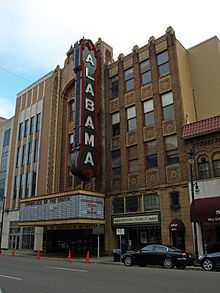 |
(#89000315) |
Roughly bounded by 3rd Ave., N., 20th St., N., Morris Ave., and 17th St., N.; also 1914, 1917, 1919, and 1930 4th Ave., N. 33°30′51″N 86°48′30″W / 33.514167°N 86.808333°W |
Second set of boundaries represent a boundary increase of June 26, 1998 | |
| 32 | Downtown Ensley Historic District | 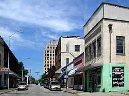 |
(#09000604) |
17th-21st Sts. Ensley & Avenues C-H 33°30′53″N 86°53′50″W / 33.514722°N 86.897222°W |
||
| 33 | Dr. Pepper Syrup Plant | _Birmingham%2C_AL.JPG) |
(#90001317) |
2829 2nd Ave., S. 33°31′00″N 86°48′06″W / 33.516667°N 86.801667°W |
||
| 34 | East End Baptist Church | _Birmingham%2C_AL.JPG) |
(#05000292) |
2609 6th Ave., S. 33°30′45″N 86°47′33″W / 33.5125°N 86.7925°W |
||
| 35 | Empire Building | 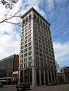 |
(#82002040) |
1928 1st Ave., N. 33°30′52″N 86°48′21″W / 33.514444°N 86.805833°W |
||
| 36 | Enslen House | _Birmingham%2C_AL.JPG) |
(#75000314) |
2737 Highland Ave. 33°30′13″N 86°47′02″W / 33.503611°N 86.783889°W |
Currently used as the Trimmier Law Firm. | |
| 37 | Cathedral Church of the Advent | 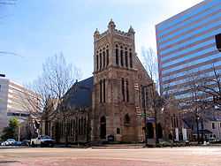 |
(#83002972) |
20th St. and 6th Ave., N. 33°31′09″N 86°48′30″W / 33.519167°N 86.808333°W |
||
| 38 | Exclusive Furniture Shop | Upload image | (#84000626) |
704 29th St., S. 33°30′42″N 86°47′16″W / 33.511667°N 86.787778°W |
||
| 39 | Federal Reserve Bank of Atlanta-Birmingham Branch | 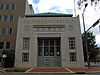 |
(#03000230) |
1801 5th Ave., N. 33°31′06″N 86°48′38″W / 33.518333°N 86.810556°W |
||
| 40 | Fire Station No. 3 | 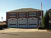 |
(#90001554) |
2210 Highland Ave. 33°30′08″N 86°47′25″W / 33.502222°N 86.790278°W |
||
| 41 | Fire Station No. 6 | 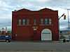 |
(#90001555) |
317 15th St., N. 33°30′46″N 86°48′48″W / 33.512778°N 86.813333°W |
||
| 42 | Fire Station No. 10 |  |
(#90001556) |
4120 2nd Ave., S. 33°31′30″N 86°46′27″W / 33.525°N 86.774167°W |
||
| 43 | Fire Station No. 11 |  |
(#90001557) |
1250 13th St., N. 33°31′30″N 86°49′24″W / 33.525°N 86.823333°W |
||
| 44 | Fire Station No. 12 |  |
(#90001558) |
15 57th St., S. 33°32′30″N 86°45′00″W / 33.541667°N 86.75°W |
||
| 45 | Fire Station No. 15 | Upload image | (#90001559) |
1345 Steiner Ave., SW. 33°29′25″N 86°51′12″W / 33.490278°N 86.853333°W |
||
| 46 | Fire Station No. 16 | Upload image | (#90001560) |
1621 Ave. G 33°30′52″N 86°53′34″W / 33.514444°N 86.892778°W |
||
| 47 | Fire Station No. 19 | Upload image | (#90001561) |
7713 Division Ave. 33°33′40″N 86°43′37″W / 33.561111°N 86.726944°W |
||
| 48 | Fire Station No. 22 | Upload image | (#90001562) |
3114 Clairmont Ave. 33°30′44″N 86°46′59″W / 33.512222°N 86.783056°W |
||
| 49 | First Baptist Church, East Thomas | Upload image | (#05000291) |
419 11th Court, W. 33°31′26″N 86°50′35″W / 33.523889°N 86.843056°W |
||
| 50 | First Baptist Church, Kingston | Upload image | (#05000300) |
4600 9th Ave., N. 33°32′30″N 86°46′06″W / 33.541667°N 86.768333°W |
||
| 51 | First Christian Church Education Building | Upload image | (#80000692) |
2100 7th Ave., N. 33°31′17″N 86°48′29″W / 33.521389°N 86.808056°W |
Demolished, now a parking lot for the Jefferson County Courthouse | |
| 52 | First Ebenezer Baptist Church | Upload image | (#05000299) |
420 Graymont Ave., N., Smithfield 33°30′47″N 86°49′44″W / 33.513056°N 86.828889°W |
||
| 53 | First National-John A. Hand Building |  |
(#83002976) |
17 N. 20th St. 33°30′51″N 86°48′19″W / 33.514167°N 86.805278°W |
||
| 54 | First Presbyterian Church | 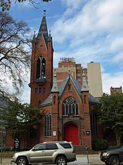 |
(#82001604) |
2100 4th Ave., N. 33°31′06″N 86°48′22″W / 33.518333°N 86.806111°W |
||
| 55 | First United Methodist Church |  |
(#82001605) |
6th Ave. and 19th St., N. 33°31′06″N 86°48′22″W / 33.518333°N 86.806111°W |
||
| 56 | Five Points South Historic District |  |
(#83002973) |
Roughly bounded by 10th and 15th Aves. and 19th and 21st Sts.; also roughly bounded by 12th Ave., 19th St., 13th Ave., and 17th St.; also roughly bounded by 15th Ave., S., 20th St., S., 16th Ave., S. and 18th St. 33°29′57″N 86°47′43″W / 33.499167°N 86.795278°W |
Second and third sets of boundaries represent boundary increases of August 28, 1986 and May 15, 1991 respectively | |
| 57 | Forest Park |  |
(#80000693) |
Roughly bounded by Highland Golf Course, 38th St. and Cherry St., Clairmont and Linwood Rds., and Overlook Ave. 33°30′50″N 86°46′05″W / 33.513889°N 86.768056°W |
||
| 58 | Fourth Avenue Historic District |  |
(#82002041) |
1600-1800 blocks of 4th Ave., N. and part of the 300 blocks of 17th and 18th Sts., N. 33°30′55″N 86°48′40″W / 33.515278°N 86.811111°W |
||
| 59 | Fox Building | Upload image | (#80000694) |
19th St. and 4th Ave. 33°30′59″N 86°48′34″W / 33.516389°N 86.809444°W |
Demolished in 1981[6] | |
| 60 | A. G. Gaston Building |  |
(#00001028) |
1527 5th Ave., N. 33°30′54″N 86°48′51″W / 33.515°N 86.814167°W |
||
| 61 | John D. and Katherine Gleissner Lustron House |  |
(#00000133) |
2420 Chahaba Rd. 33°29′27″N 86°46′44″W / 33.490833°N 86.778889°W |
||
| 62 | Glen Iris Park Historic District |  |
(#84000628) |
1-20 Glen Iris Park 33°29′22″N 86°48′41″W / 33.489444°N 86.811389°W |
||
| 63 | Graymont School | Upload image | (#07000838) |
300 8th Ave., W. 33°31′00″N 86°50′31″W / 33.516667°N 86.841944°W |
||
| 64 | Hanover Court Apartments | Upload image | (#88000446) |
2620 Highland Ave. 33°30′15″N 86°47′08″W / 33.504167°N 86.785556°W |
||
| 65 | Hanover Place Historic District | Upload image | (#03001132) |
Roughly bounded by Highland Ave., Hanover Cir., and U.S. Route 31 33°30′22″N 86°47′12″W / 33.506111°N 86.786667°W |
||
| 66 | Heaviest Corner on Earth |  |
(#85001502) |
1st Ave., N. and 20th St., N. 33°30′52″N 86°48′21″W / 33.514444°N 86.805833°W |
||
| 67 | Highland Avenue Historic District | 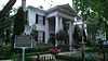 |
(#77000206) |
2000 block through the 3200 block of 11th Court, S. 33°30′18″N 86°46′59″W / 33.505°N 86.783056°W |
||
| 68 | Highland Plaza Apartments | 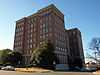 |
(#84000630) |
2250 Highland Ave., S 33°30′10″N 86°47′23″W / 33.502778°N 86.789722°W |
||
| 69 | Hotel Redmont | 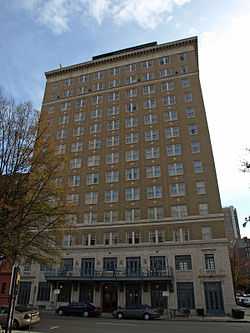 |
(#83002974) |
2101 5th Ave., N. 33°31′07″N 86°48′23″W / 33.518611°N 86.806389°W |
||
| 70 | Howard College Estates Historic District | Upload image | (#99000467) |
Roughly along 77th Way, 77th Place, Vanderbilt St., 8th Court, 8th, Rugby, and Belmont Aves. 33°33′21″N 86°42′58″W / 33.555833°N 86.716111°W |
||
| 71 | Ideal Department Store Building | 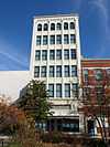 |
(#85000918) |
111 19th St., N. 33°30′52″N 86°48′26″W / 33.514444°N 86.807222°W |
||
| 72 | Jefferson County Courthouse |  |
(#82001606) |
716 21st St., N. 33°26′56″N 86°48′32″W / 33.448889°N 86.808889°W |
||
| 73 | A. D. King House | Upload image | (#08000428) |
721 12th St. Ensley 33°31′06″N 86°53′22″W / 33.518302°N 86.889582°W |
Civil Rights Movement in Birmingham, Alabama 1933-1979 MPS | |
| 74 | S. H. Kress and Company Building | 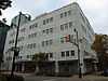 |
(#82002042) |
3rd Ave. and 19th St. 33°30′57″N 86°48′29″W / 33.515833°N 86.808056°W |
||
| 75 | Lakeview School | Upload image | (#77000207) |
2800 Clairmont Ave. 33°30′34″N 86°47′11″W / 33.509444°N 86.786389°W |
||
| 76 | Lakewood Historic District | Upload image | (#00000710) |
Roughly bounded by Lee Ave., 82nd St., Spring St., and 80th St. 33°33′38″N 86°42′44″W / 33.560556°N 86.712222°W |
||
| 77 | Joseph Loveman & Loeb Department Store | 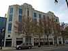 |
(#83002971) |
214-224 19th St., N. 33°30′54″N 86°48′30″W / 33.515°N 86.808333°W |
||
| 78 | Lustron House on Columbiana Road | Upload image | (#00000131) |
430 Columbiana Rd. 33°27′50″N 86°49′07″W / 33.463889°N 86.818611°W |
||
| 79 | Manchester Terrace | Upload image | (#89000163) |
720-728 S. 29th St. 33°30′43″N 86°47′17″W / 33.511944°N 86.788056°W |
||
| 80 | McAdory Building | 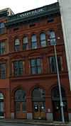 |
(#79000388) |
2013 1st Ave., N 33°30′52″N 86°48′18″W / 33.514444°N 86.805°W |
||
| 81 | Milner Heights Historic District | Upload image | (#03001130) |
Roughly bounded by 28th St., Highland Ave., 27th Ave., Arlington Ave., and 23rd St. 33°30′08″N 86°47′10″W / 33.502222°N 86.786111°W |
||
| 82 | Morris Avenue Historic District | Upload image | (#73000349) |
2000-2400 blocks of Morris Ave. 33°30′53″N 86°48′06″W / 33.514722°N 86.801667°W |
||
| 83 | Morris Avenue-First Avenue North Historic District | 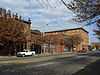 |
(#86000009) |
2000-2400 blocks of Morris Ave. and 2100-2500 blocks of 1st Ave., N. 33°30′58″N 86°48′05″W / 33.516111°N 86.801389°W |
||
| 84 | Mount Ararat Baptist Church | Upload image | (#05000307) |
1920 Slayden Ave., Ensley 33°31′06″N 86°54′29″W / 33.518333°N 86.908056°W |
||
| 85 | Morrow and Sinnige Nabers Building | 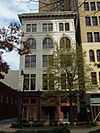 |
(#80000695) |
109 20th St., N. 33°30′53″N 86°48′21″W / 33.514722°N 86.805833°W |
||
| 86 | New Pilgrim Baptist Church | Upload image | (#05000306) |
903 6th Ave., S. 33°30′04″N 86°48′55″W / 33.501111°N 86.815278°W |
||
| 87 | New Rising Star Baptist Church | Upload image | (#05000305) |
3104 33rd Place N., Collegeville 33°33′22″N 86°47′58″W / 33.556111°N 86.799444°W |
||
| 88 | Norwood Boulevard Historic District | Upload image | (#01001166) |
2800-3624 Norwood Boulevard 33°32′22″N 86°48′04″W / 33.539444°N 86.801111°W |
||
| 89 | Oak Hill Cemetery | 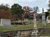 |
(#77000208) |
1120 N. 19th St. 33°31′32″N 86°49′00″W / 33.525556°N 86.816667°W |
||
| 90 | Orlando Apartments | 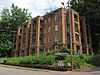 |
(#90000309) |
2301 15th Ave., S. 33°29′50″N 86°47′17″W / 33.497222°N 86.788056°W |
||
| 91 | Peace Baptist Church | Upload image | (#05000293) |
302 6th St., N. 33°30′32″N 86°49′37″W / 33.508889°N 86.826944°W |
||
| 92 | Phelan Park Historic District | 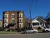 |
(#88003241) |
Roughly bounded by 13th Ave., S., 14th St., S., 16th Ave., S., and 13th Pl., S. 33°29′36″N 86°48′09″W / 33.493333°N 86.8025°W |
||
| 93 | Powell Avenue Steam Plant | Upload image | (#14001002) |
1800 Powell Ave., S. 33°30′41″N 86°48′25″W / 33.5115°N 86.8069°W |
||
| 94 | Powell School | 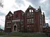 |
(#76000331) |
2331 6th Ave., N. 33°31′16″N 86°48′13″W / 33.521111°N 86.803611°W |
||
| 95 | Pratt City Carline Historic District | Upload image | (#89000118) |
Ave. U from Ave. A to Carline and Carline from Ave. W to 6th St. 33°31′57″N 86°53′01″W / 33.5325°N 86.883611°W |
||
| 96 | Pratt School | Upload image | (#93001591) |
306 Ave. U 33°31′58″N 86°53′31″W / 33.532778°N 86.891944°W |
||
| 97 | Quinlan Castle |  |
(#84000632) |
2030 9th Ave., S. 33°30′13″N 86°47′48″W / 33.503611°N 86.796667°W |
||
| 98 | Ramsay-McCormack Building | Upload image | (#08001273) |
1823-1825 Ave. E 33°30′50″N 86°53′47″W / 33.513825°N 86.896367°W |
||
| 99 | Red Mountain Suburbs Historic District | Upload image | (#85002719) |
Roughly bounded by Crest and Argyle and Altamont, Country Club, Salisbury, and Lanark Rds. 33°30′04″N 86°46′30″W / 33.501111°N 86.775°W |
Extends into Mountain Brook, elsewhere in Jefferson County | |
| 100 | William Reed House | Upload image | (#87001778) |
888 Twin Lake Dr. 33°37′05″N 86°40′30″W / 33.618056°N 86.675°W |
||
| 101 | Rhodes Park | Upload image | (#82002043) |
Roughly bounded by S. 10th, S. 13th, and Highland Aves. and S. 28th and S. 30th Sts. 33°30′22″N 86°46′42″W / 33.506111°N 86.778333°W |
||
| 102 | Rickwood Field | 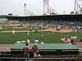 |
(#92001826) |
1137 2nd Ave., W. 33°30′22″N 86°50′33″W / 33.506111°N 86.8425°W |
||
| 103 | Ridgely Apartments | |
(#84000634) |
608 21st St., N. 33°31′11″N 86°48′28″W / 33.519722°N 86.807778°W |
||
| 104 | Roebuck Springs Historic District | Upload image | (#99000149) |
Roughly off of Blountsville County Road 33°34′38″N 86°42′16″W / 33.577222°N 86.704444°W |
||
| 105 | Saint Andrew's Episcopal Church | 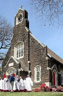 |
(#86001959) |
1164 11th Ave., S. 33°29′44″N 86°48′28″W / 33.495556°N 86.807778°W |
||
| 106 | St. Luke AME Church | Upload image | (#05000296) |
2803 21st Ave., N. 33°32′40″N 86°48′35″W / 33.544444°N 86.809722°W |
||
| 107 | St. Luke AME Zion Church | Upload image | (#05000295) |
3937 12th Ave., N. 33°32′40″N 86°46′51″W / 33.544444°N 86.780833°W |
||
| 108 | St. Paul's Catholic Church | 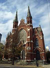 |
(#82001607) |
2120 3rd Ave., N. 33°31′04″N 86°48′18″W / 33.517778°N 86.805°W |
||
| 109 | Sardis Baptist Church | Upload image | (#05000298) |
1240 4th St., N. 33°31′26″N 86°49′49″W / 33.523767°N 86.83025°W |
||
| 110 | Second Presbyterian Church | 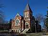 |
(#86002616) |
10th Ave. and 12th St., S. 33°29′50″N 86°48′33″W / 33.497222°N 86.809167°W |
||
| 111 | Shady Grove Baptist Church | Upload image | (#05000297) |
3444 31st Way, N., Collegeville 33°33′41″N 86°48′15″W / 33.561389°N 86.804167°W |
||
| 112 | Sixteenth Street Baptist Church |  |
(#80000696) |
1530 6th Ave., N. at 16th St. 33°31′00″N 86°48′53″W / 33.516667°N 86.814722°W |
||
| 113 | Sloss Blast Furnace Site | 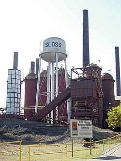 |
(#72000162) |
1st Ave. at 32nd St. 33°31′14″N 86°47′34″W / 33.520556°N 86.792778°W |
||
| 114 | Slossfield Community Center | Upload image | (#08000457) |
1901 25th Ct., N. 33°32′38″N 86°49′34″W / 33.543934°N 86.825981°W |
||
| 115 | Joseph Riley Smith Historic District | Upload image | (#85002898) |
300-400 blocks of 10th Ave., 100-400 blocks of 9th Ct., 944 4th St., W., and 948 3rd St., W. 33°31′02″N 86°50′26″W / 33.517222°N 86.840556°W |
||
| 116 | Smithfield Historic District | Upload image | (#85002899) |
Roughly bounded by 8th Ave., N., 6th St., N., 4th Terrace, N., and 1st St., N.; also roughly along 4th Ct. and Center St. 33°30′41″N 86°49′52″W / 33.511389°N 86.831111°W |
Second set of boundaries represent a boundary increase of August 14, 1998 | |
| 117 | South East Lake Historic District | Upload image | (#97000652) |
Roughly bounded by 78th and 8th Sts., and Division, 1st, 2nd, and 5th Aves. 33°33′56″N 86°43′14″W / 33.565556°N 86.720556°W |
||
| 118 | South Highlands of East Lake Historic District | Upload image | (#03001136) |
Roughly bounded by 8th Ave., 85th St., 5th Ave., and 78th St. 33°35′37″N 86°42′51″W / 33.593611°N 86.714167°W |
||
| 119 | Southside Historic District | Upload image | (#05000647) |
2800 University Boulevard, parts of 4th-7th Aves., S., and 22nd-32nd Sts., S. Boundary increase (listed June 30, 2011): Within same general boundaries as original listing 33°30′46″N 86°47′26″W / 33.5128°N 86.7906°W |
||
| 120 | Steiner Bank Building | 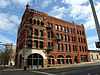 |
(#74000414) |
2101 1st Ave., N. 33°30′53″N 86°48′14″W / 33.514722°N 86.803889°W |
||
| 121 | Stonecroft | Upload image | (#01001290) |
1453 Shades Crest Rd. 33°26′16″N 86°49′11″W / 33.437778°N 86.819722°W |
||
| 122 | Thomas By-Product Coke Works Historic District | Upload image | (#95001060) |
Roughly bounded by railroad tracks and the sand and gravel quarry 33°31′33″N 86°51′36″W / 33.525833°N 86.86°W |
||
| 123 | Thomas Historic District | Upload image | (#89000119) |
Roughly the area between 1st and 8th Sts., north of Village Creek and west of the St. Louis and San Francisco railroad tracks 33°31′44″N 86°51′37″W / 33.528889°N 86.860278°W |
||
| 124 | U.S. Post Office | 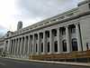 |
(#76000332) |
1800 5th Ave., N. 33°31′02″N 86°48′38″W / 33.517222°N 86.810556°W |
||
| 125 | Vulcan | 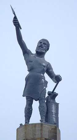 |
(#76000333) |
Vulcan Park, U.S. Route 31, S. 33°29′30″N 86°47′44″W / 33.491667°N 86.795556°W |
||
| 126 | Waters Building |  |
(#80000697) |
209-211 22nd St., N. 33°31′01″N 86°48′12″W / 33.516944°N 86.803333°W |
||
| 127 | Watts Building |  |
(#79000389) |
2008 3rd Ave., N. 33°31′00″N 86°48′25″W / 33.516667°N 86.806944°W |
||
| 128 | West End Hills Missionary Baptist Church | Upload image | (#05000303) |
1680 19th Place, SW. 33°28′11″N 86°52′10″W / 33.469722°N 86.869444°W |
||
| 129 | West End Masonic Temple | Upload image | (#87001417) |
1346 Tuscaloosa Ave. 33°29′33″N 86°51′19″W / 33.4925°N 86.855278°W |
||
| 130 | West Park |  |
(#84000636) |
5th Ave., N. and 16th St. 33°30′59″N 86°48′48″W / 33.516389°N 86.813333°W |
||
| 131 | Whilldin Building | 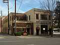 |
(#82002044) |
513-517 21st St., N. 33°31′09″N 86°48′25″W / 33.519167°N 86.806944°W |
||
| 132 | Wimberly-Thomas Warehouse | 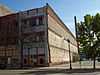 |
(#85002718) |
1809 1st Ave., S. 33°31′10″N 86°48′22″W / 33.519444°N 86.806111°W |
||
| 133 | Windham Construction Office Building | Upload image | (#84000638) |
528 8th Ave., N. 33°30′51″N 86°49′37″W / 33.514167°N 86.826944°W |
||
| 134 | Woodlawn City Hall | Upload image | (#88000990) |
5525 1st Ave., N. 33°32′20″N 86°45′11″W / 33.538889°N 86.753056°W |
||
| 135 | Woodlawn Commercial Historic District | Upload image | (#90002179) |
Area around the junction of 1st Ave., N. and 55th Pl. 33°32′24″N 86°45′09″W / 33.54°N 86.7525°W |
||
| 136 | Woodlawn Highlands Historic District | Upload image | (#06000438) |
Bounded by 5th Ave., S., Crestwood Boulevard, and 56th and 61st Sts., S. 33°32′13″N 86°45′02″W / 33.536944°N 86.750556°W |
||
| 137 | Woodlawn Historic District | Upload image | (#03001129) |
Roughly bounded by 1st Ave., N., 47th St., N., 61st St., N., and Interstates 20/59 33°32′25″N 86°45′27″W / 33.540278°N 86.7575°W |
||
| 138 | Woodward Building | 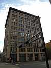 |
(#83002977) |
1927 1st Ave., N. 33°30′51″N 86°48′21″W / 33.514167°N 86.805833°W |
||
| 139 | Bernice L. Wright Lustron House | 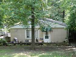 |
(#00000130) |
2424 Cahaba Rd. 33°29′26″N 86°46′43″W / 33.490556°N 86.778611°W |
||
| 140 | Wylam Fire Station | Upload image | (#90001563) |
Northeastern corner of the junction of 8th Ave. and Huron St. 33°30′17″N 86°55′17″W / 33.504722°N 86.921389°W |
||
| 141 | Peter Zinszer's Mammoth Furniture House | 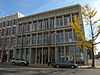 |
(#80000698) |
2115, 2117, and 2119 2nd Ave., N. 33°30′58″N 86°48′15″W / 33.516111°N 86.804167°W |
See also
| Wikimedia Commons has media related to National Register of Historic Places in Birmingham, Alabama. |
- List of National Historic Landmarks in Alabama
- National Register of Historic Places listings in Alabama
References
- ↑ The latitude and longitude information provided in this table was derived originally from the National Register Information System, which has been found to be fairly accurate for about 99% of listings. For about 1% of NRIS original coordinates, experience has shown that one or both coordinates are typos or otherwise extremely far off; some corrections may have been made. A more subtle problem causes many locations to be off by up to 150 yards, depending on location in the country: most NRIS coordinates were derived from tracing out latitude and longitudes off of USGS topographical quadrant maps created under the North American Datum of 1927, which differs from the current, highly accurate WGS84 GPS system used by most on-line maps. Chicago is about right, but NRIS longitudes in Washington are higher by about 4.5 seconds, and are lower by about 2.0 seconds in Maine. Latitudes differ by about 1.0 second in Florida. Some locations in this table may have been corrected to current GPS standards.
- ↑ "National Register of Historic Places: Weekly List Actions". National Park Service, United States Department of the Interior. Retrieved on May 1, 2015.
- ↑ Numbers represent an ordering by significant words. Various colorings, defined here, differentiate National Historic Landmarks and historic districts from other NRHP buildings, structures, sites or objects.
- ↑ "National Register Information System". National Register of Historic Places. National Park Service. 2009-03-13.
- ↑ The eight-digit number below each date is the number assigned to each location in the National Register Information System database, which can be viewed by clicking the number.
- ↑ "Case 53 - Committee to Save the Fox Building v. Birmingham Branch of the Federal Reserve Bank". An Overview of Federal Historic Preservation Law, 1966-1996. Advisory Council on Historic Preservation. Retrieved November 22, 2011.
| |||||||||||||||||||||

