| [3] |
Name on the Register |
Image |
Date listed[4] |
Location |
City or town |
Description |
|---|
| 1 |
American Legion Hall, Post 32 |
Upload image |
02014-06-27-0000June 27, 2014
(#14000386) |
130 N. 5th St.
44°29′26″N 108°03′14″W / 44.4905°N 108.054°W / 44.4905; -108.054 (American Legion Hall, Post 32) |
Greybull |
|
| 2 |
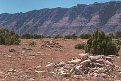
Bad Pass Trail |
|
01975-10-29-0000October 29, 1975
(#75000215) |
East of Warren along the Bighorn River in the Bighorn Canyon National Recreation Area
45°03′07″N 108°15′44″W / 45.051944°N 108.262222°W / 45.051944; -108.262222 (Bad Pass Trail) |
Warren |
|
| 3 |
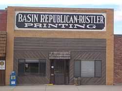
Basin Republican-Rustler Printing Building |
|
01976-07-19-0000July 19, 1976
(#76001948) |
409 W. C St.
44°22′51″N 108°02′22″W / 44.380833°N 108.039444°W / 44.380833; -108.039444 (Basin Republican-Rustler Printing Building) |
Basin |
|
| 4 |
Bear Creek Ranch Medicine Wheel (48BH48) |
Upload image |
01987-05-04-0000May 4, 1987
(#87000661) |
Address Restricted
|
Greybull |
|
| 5 |
Big Horn Academy Historic District |
Upload image |
01992-03-26-0000March 26, 1992
(#92000285) |
25 and 35 E. 1st S.
44°52′56″N 108°28′04″W / 44.882222°N 108.467778°W / 44.882222; -108.467778 (Big Horn Academy Historic District) |
Cowley |
|
| 6 |
Black Mountain Archeological District (48BH900/902/1064/106 7/1126/1127/1128/1129) |
Upload image |
01987-07-02-0000July 2, 1987
(#86003459) |
Summit and southeastern slopes of Black Mountain[5]
44°31′24″N 107°39′42″W / 44.523333°N 107.661667°W / 44.523333; -107.661667 (Black Mountain Archeological District (48BH900/902/1064/106 7/1126/1127/1128/1129)) |
Shell |
|
| 7 |
Bridger Immigrant Road-Dry Creek Crossing |
Upload image |
01975-01-17-0000January 17, 1975
(#75001900) |
26 miles east of Cody on U.S. Route 14
44°27′34″N 108°31′44″W / 44.459444°N 108.528889°W / 44.459444; -108.528889 (Bridger Immigrant Road-Dry Creek Crossing) |
Cody |
|
| 8 |
Carey Block |
Upload image |
02009-12-18-0000December 18, 2009
(#09001110) |
602 Greybull Ave.
44°29′20″N 108°03′19″W / 44.488906°N 108.055414°W / 44.488906; -108.055414 (Carey Block) |
Greybull |
|
| 9 |
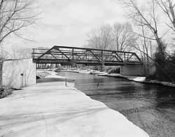
EJE Bridge over Shell Creek |
|
01985-02-22-0000February 22, 1985
(#85000415) |
County Road CN9-57
44°32′05″N 107°48′06″W / 44.534722°N 107.801667°W / 44.534722; -107.801667 (EJE Bridge over Shell Creek) |
Shell |
|
| 10 |
EJP County Line Bridge |
Upload image |
01985-02-22-0000February 22, 1985
(#85000412) |
Road CN9-60
44°09′59″N 107°41′01″W / 44.166389°N 107.683611°W / 44.166389; -107.683611 (EJP County Line Bridge) |
Hyattville |
|
| 11 |
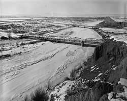
EJZ Bridge over Shoshone River |
|
01985-02-22-0000February 22, 1985
(#85000413) |
County Road CN9-111
44°50′18″N 108°26′03″W / 44.838333°N 108.434167°W / 44.838333; -108.434167 (EJZ Bridge over Shoshone River) |
Lovell |
|
| 12 |
Hanson Site |
Upload image |
01978-12-15-0000December 15, 1978
(#78002817) |
Address Restricted
|
Shell |
|
| 13 |
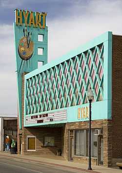
Hyart Theater |
|
02009-01-08-0000January 8, 2009
(#08001304) |
251 E. Main St.
44°50′15″N 108°23′18″W / 44.83758°N 108.38822°W / 44.83758; -108.38822 (Hyart Theater) |
Lovell |
|
| 14 |
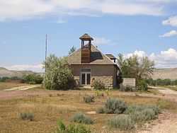
Lower Shell School House |
|
01985-02-07-0000February 7, 1985
(#85000247) |
U.S. Route 14
44°31′15″N 107°56′03″W / 44.520833°N 107.934167°W / 44.520833; -107.934167 (Lower Shell School House) |
Greybull |
|
| 15 |
M L Ranch |
|
01992-07-15-0000July 15, 1992
(#92000836) |
Off Alternate U.S. Route 14 near the eastern shore of Bighorn Lake, 13 miles east of Lovell, Bighorn Canyon National Recreation Area
44°49′49″N 108°09′28″W / 44.830278°N 108.157778°W / 44.830278; -108.157778 (M L Ranch) |
Lovell |
|
| 16 |
Medicine Lodge Creek Site |
Upload image |
01973-07-05-0000July 5, 1973
(#73001926) |
Address Restricted
|
Hyattville |
|
| 17 |
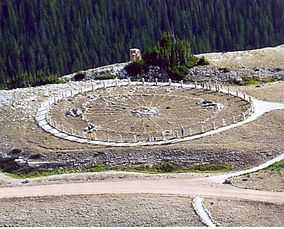
Medicine Wheel-Medicine Mountain |
|
01969-04-16-0000April 16, 1969
(#69000184) |
Near the summit of Medicine Mountain[6]
44°49′34″N 107°55′18″E / 44.826111°N 107.921667°E / 44.826111; 107.921667 (Medicine Wheel-Medicine Mountain) |
Kane |
|
| 18 |
Paint Rock Canyon Archeological Landscape District |
Upload image |
01990-07-12-0000July 12, 1990
(#80004881) |
Address Restricted
|
Hyattville |
|
| 19 |
Rairden Bridge |
Upload image |
01985-02-22-0000February 22, 1985
(#85000414) |
South of Big Horn County Road CN9-30
44°11′40″N 107°54′53″W / 44.194444°N 107.914722°W / 44.194444; -107.914722 (Rairden Bridge) |
Manderson |
|
| 20 |
Southsider Shelter |
Upload image |
02012-08-01-0000August 1, 2012
(#12000470) |
Address Restricted
|
Ten Sleep |
|
| 21 |
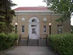
US Post Office-Basin Main |
|
01987-05-19-0000May 19, 1987
(#87000779) |
402 W. C St.
44°22′53″N 108°02′19″W / 44.381389°N 108.038611°W / 44.381389; -108.038611 (US Post Office-Basin Main) |
Basin |
|
| 22 |
US Post Office-Greybull Main |
Upload image |
01987-05-22-0000May 22, 1987
(#87000780) |
401 Greybull Ave.
44°29′19″N 108°03′08″W / 44.488611°N 108.052222°W / 44.488611; -108.052222 (US Post Office-Greybull Main) |
Greybull |
|