National Register of Historic Places listings in Bexar County, Texas
List of Registered Historic Places in Bexar County, Texas
This is intended to be a complete list of properties and districts listed on the National Register of Historic Places in Bexar County, Texas. The locations of National Register properties and districts (at least for all showing latitude and longitude coordinates below) may be seen in a Google map by clicking on "Map of all coordinates".[1]
- This National Park Service list is complete through NPS recent listings posted May 1, 2015.[2]
Current listings
| [3] | Name on the Register[4] | Image | Date listed[5] | Location | City or town | Description |
|---|---|---|---|---|---|---|
| 1 | Alamo Methodist Church |  |
(#79003446) |
1150 S. Alamo St. 29°24′41″N 98°29′35″W / 29.411417°N 98.492917°W |
San Antonio | A church built in 1912. |
| 2 | Alamo National Bank Building |  |
(#84001574) |
316 E. Commerce St. 29°25′26″N 98°29′21″W / 29.423833°N 98.489167°W |
San Antonio | |
| 3 | Alamo National Bank Building |  |
(#06000364) |
105 S. St. Mary's St. 29°25′27″N 98°29′30″W / 29.424167°N 98.491667°W |
San Antonio | |
| 4 | Alamo Plaza Historic District |  |
(#77001425) |
Roughly bounded by S. Broadway, Commerce, Bonham and Travis Sts. 29°25′31″N 98°29′08″W / 29.425278°N 98.485556°W |
San Antonio | |
| 5 | Alamo Portland and Roman Cement Works |  |
(#76002005) |
Brackenridge Park 29°27′38″N 98°28′36″W / 29.460556°N 98.476667°W |
San Antonio | |
| 6 | The Alamo |  |
(#66000808) |
Alamo Plaza 29°25′32″N 98°29′10″W / 29.425556°N 98.486111°W |
San Antonio | |
| 7 | Alamo Stadium and Gymnasium |  |
(#11000651) |
110 Tuleta Drive 29°27′46″N 98°28′42″W / 29.462847°N 98.478333°W |
San Antonio | |
| 8 | Aue Stagecoach Inn |  |
(#79002912) |
Boerne Stage Rd. and I-10 29°39′55″N 98°37′43″W / 29.6652°N 98.62875°W |
Leon Springs | |
| 9 | Aztec Theater |  |
(#92001403) |
104 N. St. Mary's St. 29°25′28″N 98°29′27″W / 29.424444°N 98.490833°W |
San Antonio | |
| 10 | Barnes-Laird House |  |
(#88001146) |
103 W. Ashby Pl. 29°26′58″N 98°29′40″W / 29.449444°N 98.494444°W |
San Antonio | |
| 11 | Barr Building |  |
(#85000766) |
213-219 Broadway 29°25′41″N 98°29′15″W / 29.428056°N 98.4875°W |
San Antonio | |
| 12 | Base Administration Building |  |
(#87001434) |
Randolph AFB 29°32′09″N 98°16′57″W / 29.535972°N 98.2825°W |
Randolph AFB | |
| 13 | Bexar County Courthouse |  |
(#77001426) |
Main Plaza 29°25′23″N 98°29′36″W / 29.423056°N 98.493333°W |
San Antonio | |
| 14 | Blue Star Street Industrial Historic District |  |
(#94000627) |
1432 S. Alamo St. 29°24′35″N 98°29′44″W / 29.409722°N 98.495556°W |
San Antonio | |
| 15 | James Butler Bonham Elementary School |  |
(#78002890) |
925 S. St. Mary's St. 29°24′50″N 98°29′20″W / 29.413889°N 98.488889°W |
San Antonio | |
| 16 | Brackenridge Park |  |
(#11000513) |
Roughly bounded by Hildebrand Ave., Broadway & Ave. B, Josephine St., US 281, River Rd., Alpine Dr., N. St. Mary's St. 29°27′21″N 98°28′23″W / 29.455833°N 98.473056°W |
San Antonio | |
| 17 | Brady Building-Empire Theater |  |
(#99000283) |
204 E. Houston St.-226 N. St. Mary's St. 29°25′34″N 98°29′28″W / 29.42605°N 98.49114°W |
San Antonio | |
| 18 | Brooke Army Medical Center |  |
(#01001281) |
Building 1000, Stanley Rd., Fort Sam Houston 29°27′58″N 98°26′57″W / 29.466111°N 98.449167°W |
San Antonio | |
| 19 | Buckeye Park Gate | 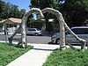 |
(#04001169) |
1600 W. Wildwood 29°28′45″N 98°31′17″W / 29.479167°N 98.521389°W |
San Antonio | Sculpture by Dionicio Rodriguez |
| 20 | Builders Exchange Building |  |
(#94001335) |
152 Pecan St. 29°25′42″N 98°29′30″W / 29.428472°N 98.491667°W |
San Antonio | |
| 21 | Bungalow Colony Historic District | Upload image | (#03000627) |
Roughly bounded by Duncan Dr., Crockett Dr., Walker Rd. and Robins Dr. 29°22′48″N 98°33′39″W / 29.38°N 98.560833°W |
San Antonio | |
| 22 | Burns Building |  |
(#99000284) |
401 E. Houston St. 29°25′35″N 98°29′18″W / 29.426389°N 98.488333°W |
San Antonio | |
| 23 | Bushnell |  |
(#82004491) |
240 Bushnell 29°27′44″N 98°29′16″W / 29.462222°N 98.487778°W |
San Antonio | |
| 24 | Calcasieu Building |  |
(#96000588) |
202-214 Broadway 29°25′40″N 98°29′14″W / 29.427639°N 98.487361°W |
San Antonio | |
| 25 | George Washington Carver Library and Auditorium | Upload image | (#03001162) |
226 N. Hackberry St. 29°25′19″N 98°28′21″W / 29.421944°N 98.4725°W |
San Antonio | |
| 26 | Central Trust Company Building |  |
(#82004492) |
603 Navarro St. 29°25′36″N 98°29′24″W / 29.426667°N 98.49°W |
San Antonio | |
| 27 | Chinese Sunken Garden Gate |  |
(#04001167) |
Brackenridge Park, 4000 N. St. Mary's St. 29°27′45″N 98°28′38″W / 29.4625°N 98.477222°W |
San Antonio | Sculpture by Dionicio Rodriguez |
| 28 | Church of Nuestra Senora de la Candelaria y Guadalupe |  |
(#75001949) |
115 Main Ave. 29°25′28″N 98°29′39″W / 29.424444°N 98.494167°W |
San Antonio | |
| 29 | City of San Antonio Municipal Auditorium |  |
(#81000624) |
100 Auditorium Circle 29°25′50″N 98°29′20″W / 29.430556°N 98.48875°W |
San Antonio | |
| 30 | City Public Service Company Building |  |
(#95001422) |
201 N. St. Mary's St. 29°25′31″N 98°29′30″W / 29.425278°N 98.491667°W |
San Antonio | |
| 31 | L. B. Clegg House |  |
(#79002913) |
123 W. Park Ave. 29°26′39″N 98°29′43″W / 29.44415°N 98.49533°W |
San Antonio | |
| 32 | Dionicio Rodriguez Bridge in Brackenridge Park | |
(#04001166) |
4000 N. St. Mary's St. 29°27′53″N 98°28′06″W / 29.464722°N 98.468472°W |
San Antonio | Sculpture by Dionicio Rodriguez |
| 33 | Emil Elmendorf House |  |
(#80004077) |
509 Burleson St. 29°25′58″N 98°28′22″W / 29.43282°N 98.47285°W |
San Antonio | |
| 34 | Espada Aqueduct |  |
(#66000809) |
Espada Rd., E of U.S. 281S 29°19′56″N 98°27′40″W / 29.332222°N 98.461111°W |
San Antonio | |
| 35 | The Fairmount Hotel | |
(#88000753) |
401 S. Alamo 29°25′14″N 98°29′18″W / 29.420556°N 98.488333°W |
San Antonio | |
| 36 | Fence at Alamo Cement Company |  |
(#05000861) |
7300 Jones Maltsberger Rd. 29°29′51″N 98°28′44″W / 29.4975°N 98.47875°W |
San Antonio | Sculpture by Dionicio Rodriguez |
| 37 | First National Bank of San Antonio |  |
(#72001348) |
239 E. Commerce St. 29°25′28″N 98°29′25″W / 29.4244°N 98.4902°W |
San Antonio | |
| 38 | Floore Country Store |  |
(#05001402) |
14492 Old Bandera Rd. 29°34′40″N 98°41′26″W / 29.577778°N 98.690556°W |
Helotes | |
| 39 | Fort Sam Houston |  |
(#75001950) |
N edge of San Antonio 29°26′52″N 98°27′52″W / 29.447778°N 98.464444°W |
San Antonio | |
| 40 | Fountain at Alamo Cement Company |  |
(#05000862) |
7300 Jones Maltsberger Rd. 29°29′51″N 98°28′45″W / 29.4975°N 98.479167°W |
San Antonio | Sculpture by Dionicio Rodriguez |
| 41 | Fourth Ward School | Upload image | (#78002891) |
141 Lavaca St. 29°25′02″N 98°29′12″W / 29.417222°N 98.486667°W |
San Antonio | |
| 42 | Thomas H. Franklin House |  |
(#86001135) |
105 E. French Pl. 29°27′02″N 98°29′37″W / 29.450556°N 98.493611°W |
San Antonio | |
| 43 | Friedrich Complex |  |
(#02001059) |
1617 E. Commerce St. 29°25′14″N 98°28′14″W / 29.420556°N 98.470556°W |
San Antonio | |
| 44 | Garcia-Garza House |  |
(#83003091) |
214 W. Salinas St. 29°25′41″N 98°29′42″W / 29.428056°N 98.495°W |
San Antonio | |
| 45 | Goad Motor Company Building |  |
(#97001530) |
317 Lexington Ave. 29°26′00″N 98°29′25″W / 29.433333°N 98.490278°W |
San Antonio | |
| 46 | Carl Hilmar Guenther House |  |
(#90001539) |
205 E. Guenther St. 29°24′41″N 98°29′45″W / 29.41145°N 98.49582°W |
San Antonio | |
| 47 | Gunter Hotel |  |
(#06001233) |
205 E. Houston St. 29°25′36″N 98°29′28″W / 29.42669°N 98.491111°W |
San Antonio | |
| 48 | A. H. Halff House |  |
(#86002180) |
601 Howard St. 29°26′31″N 98°29′45″W / 29.441944°N 98.495833°W |
San Antonio | |
| 49 | Hangar 9 |  |
(#70000895) |
Brooks Air Force Base Inner Circle Rd. 29°20′38″N 98°26′39″W / 29.343889°N 98.444167°W |
San Antonio | |
| 50 | Ethel Wilson Harris House |  |
(#01000325) |
6519 San Jose Dr.-San Antonio Missions NHP 29°21′48″N 98°28′50″W / 29.363333°N 98.480417°W |
San Antonio | Modern Movement house built in 1956, designed by Robert Harris, which happens to be included in the San Antonio Missions National Historical Park |
| 51 | John S. Harrison House |  |
(#06000551) |
14997 Evans Rd. 29°34′32″N 98°18′19″W / 29.5755°N 98.305306°W |
Selma | |
| 52 | The Havana |  |
(#86000725) |
1015 Navarro St. 29°25′51″N 98°29′23″W / 29.430833°N 98.489722°W |
San Antonio | |
| 53 | Hays Street Bridge |  |
(#12000787) |
Hays St. over UPRR, N. Cherry, & Chestnut Sts. 29°25′49″N 98°28′40″W / 29.43034°N 98.47772°W |
San Antonio | Historic Bridges of Texas MPS |
| 54 | Heidemann Ranch | Upload image | (#11000423) |
26090 Toutant Beauregard Rd. 29°41′18″N 98°42′13″W / 29.688333°N 98.703611°W |
San Antonio | Farms and Ranches of Bexar County, Texas MPS |
| 55 | Johann and Anna Heidgen House |  |
(#04000591) |
121 Starr St. 29°25′34″N 98°28′56″W / 29.426111°N 98.482222°W |
San Antonio | |
| 56 | Heimann Building |  |
(#04001396) |
118 N. Medina St. 29°25′37″N 98°30′17″W / 29.426806°N 98.504861°W |
San Antonio | |
| 57 | Herrera Ranch | Upload image | (#10000737) |
Old Somerset Rd. at Medina River 29°16′59″N 98°36′51″W / 29.283056°N 98.614028°W |
Von Ormy | |
| 58 | Huebner-Onion Homestead and Stagecoach Stop |  |
(#05000860) |
6613 Bandera Rd. 29°29′39″N 98°37′00″W / 29.494167°N 98.616667°W |
Leon Valley | |
| 59 | International & Great Northern Railroad Passenger Station |  |
(#75001951) |
Medina and Houston Sts. 29°25′37″N 98°30′19″W / 29.426944°N 98.505278°W |
San Antonio | |
| 60 | Jacala Restaurant |  |
(#04001168) |
2702 N. St. Mary's St. 29°27′01″N 98°29′13″W / 29.450278°N 98.486944°W |
San Antonio | Facade is a sculpture by Dionicio Rodriguez |
| 61 | Kelly Field Historic District |  |
(#03000626) |
Roughly encompassing the 1600 and 1700 Areas of Kelly AFB 29°22′57″N 98°34′15″W / 29.3825°N 98.570833°W |
San Antonio | |
| 62 | King William Historic District |  |
(#72001349) |
Roughly bounded by Durango, Alamo, Guenther Sts. and the San Antonio River 29°24′51″N 98°29′34″W / 29.414167°N 98.492778°W |
San Antonio | |
| 63 | Krause House | Upload image | (#10000469) |
8551 Old Pearsall Road 29°18′20″N 98°39′56″W / 29.305472°N 98.665444°W |
San Antonio | |
| 64 | La Villita Historic District |  |
(#72001350) |
Bounded by Durango, Navarro, Alamo Sts. and San Antonio River 29°25′17″N 98°29′20″W / 29.421389°N 98.488889°W |
San Antonio | |
| 65 | Lavaca Historic District | Upload image | (#00000773) |
Roughly bounded by S. Alamo St., S. Presa St., alley bet. Camargo St., Callahan Ave., Labor St., and Garfield Alley 29°24′47″N 98°29′14″W / 29.413056°N 98.487222°W |
San Antonio | |
| 66 | Robert E. Lee Hotel |  |
(#96000063) |
111 Travis St. 29°25′39″N 98°29′39″W / 29.4275°N 98.494167°W |
San Antonio | |
| 67 | Lerma's Nite Club |  |
(#11000135) |
1602-1612 N Zarzamora 29°26′40″N 98°31′29″W / 29.444306°N 98.524792°W |
San Antonio | |
| 68 | Light House |  |
(#11000131) |
300 Argyle Ave 29°28′32″N 98°28′10″W / 29.475417°N 98.469514°W |
Alamo Heights | |
| 69 | Live Oak Park Site | Upload image | (#78002889) |
Address Restricted |
Live Oak | 41BX435 |
| 70 | Livingston-Hess House |  |
(#96000036) |
228 W. Huisache Ave. 29°27′21″N 98°29′46″W / 29.455833°N 98.496111°W |
San Antonio | |
| 71 | Main and Military Plazas Historic District |  |
(#79002914) |
Roughly bounded by San Antonio River, E. Nueva, Laredo, and Houston Sts. 29°25′27″N 98°29′37″W / 29.424167°N 98.493611°W |
San Antonio | |
| 72 | Majestic Theatre | .JPG) |
(#75001952) |
230 E. Houston St. 29°25′35″N 98°29′26″W / 29.42625°N 98.490556°W |
San Antonio | |
| 73 | Maverick Building |  |
(#94001593) |
606 N. Presa 29°25′35″N 98°29′18″W / 29.42625°N 98.488472°W |
San Antonio | |
| 74 | Maverick-Altgelt Ranch and Fenstermaker-Fromme Farm | Upload image | (#79002915) |
Address Restricted |
San Antonio | 41BX493, 41BX494, 41BX495, 41BX496, 41BX497, 41BX498 |
| 75 | Maverick-Carter House |  |
(#98000844) |
119 Taylor St. 29°25′48″N 98°29′16″W / 29.42997°N 98.48779°W |
San Antonio | |
| 76 | Otto Meerscheidt House | Upload image | (#80004488) |
332 Adams St. 29°24′30″N 98°29′25″W / 29.408333°N 98.490278°W |
San Antonio | |
| 77 | Menger Soap Works |  |
(#73001958) |
400 block of N. Laredo St. 29°25′45″N 98°29′48″W / 29.429028°N 98.496667°W |
San Antonio | |
| 78 | Merchants Ice and Cold Storage Company |  |
(#02001060) |
1305 E. Houston St. 29°25′31″N 98°28′38″W / 29.425278°N 98.477222°W |
San Antonio | |
| 79 | Meyer Pottery Archeological Complex | Upload image | (#90000299) |
Address Restricted |
Atascosa | 41BX128, aka Black Hill Pottery |
| 80 | Miraflores Park |  |
(#04001176) |
800 Hildebrand 29°27′55″N 98°28′03″W / 29.46520°N 98.4675°W |
San Antonio | |
| 81 | Mission Concepcion |  |
(#70000740) |
807 Mission Rd. 29°23′27″N 98°29′28″W / 29.390833°N 98.49125°W |
San Antonio | |
| 82 | Mission Parkway | Upload image | (#75001953) |
Along San Antonio River 29°21′06″N 98°28′11″W / 29.351667°N 98.469722°W |
San Antonio | |
| 83 | Mission San Francisco de la Espada |  |
(#72001351) |
Espada Rd. 29°19′03″N 98°27′00″W / 29.3175°N 98.45°W |
San Antonio | Boundary increase January 28, 1974 |
| 84 | Mission San Juan Capistrano |  |
(#72001352) |
Mission Rd. 29°19′55″N 98°27′16″W / 29.331944°N 98.454444°W |
San Antonio | |
| 85 | Monastery of Our Lady of Charity |  |
(#99000719) |
1900 Montana 29°25′05″N 98°26′56″W / 29.418056°N 98.448889°W |
San Antonio | |
| 86 | Monte Vista Residential Historic District | Upload image | (#98001421) |
Roughly bounded by Hildebrand, Stadium, N. St. Mary's, Asby, and San Pedro Sts. 29°27′27″N 98°29′26″W / 29.4575°N 98.490556°W |
San Antonio | |
| 87 | William J. Morrison, Jr. House |  |
(#90001078) |
710 N. Olive St. 29°25′41″N 98°28′16″W / 29.428056°N 98.471111°W |
San Antonio | |
| 88 | Jose Antonio Navarro Elementary School |  |
(#78002892) |
623 S. Pecos St. 29°25′11″N 98°30′08″W / 29.419722°N 98.502222°W |
San Antonio | |
| 89 | Jose Antonio Navarro House Complex | |
(#72001353) |
228-232 S. Laredo St. 29°25′23″N 98°29′50″W / 29.423056°N 98.497361°W |
San Antonio | |
| 90 | Old Lone Star Brewery |  |
(#72001354) |
200 West Jones Ave. 29°26′13″N 98°28′53″W / 29.436944°N 98.481389°W |
San Antonio | October 26, 1972 and September 25, 1979 (boundary increase) |
| 91 | Our Lady of Mount Carmel and St. Therese Church |  |
(#98000843) |
906 Kentucky 29°26′45″N 98°31′30″W / 29.445833°N 98.525°W |
San Antonio | |
| 92 | Hiram Partee House |  |
(#84001576) |
605 Belknap Pl. 29°27′08″N 98°29′52″W / 29.452222°N 98.497778°W |
San Antonio | |
| 93 | Perez Rancho Site and Delores Crossing | Upload image | (#14000099) |
Address Restricted |
San Antonio | Lt. Col. Ygnacio Perez Stone Rancho Site, 41BX274 |
| 94 | Pershing House |  |
(#74002058) |
Staff Post Rd., Fort Sam Houston 29°26′42″N 98°28′10″W / 29.445°N 98.469306°W |
San Antonio | |
| 95 | Plehwe Complex |  |
(#83003755) |
W of Leon Springs on Boerne Stage Rd. 29°39′53″N 98°38′20″W / 29.6647°N 98.6388°W |
Leon Springs | |
| 96 | Post Chapel, Fort Sam Houston |  |
(#74002057) |
Bldg. 2200, Wilson St. 29°26′54″N 98°27′31″W / 29.448333°N 98.458611°W |
San Antonio | |
| 97 | Presnall-Watson Homestead | Upload image | (#12000192) |
Address Restricted |
San Antonio | Farms and Ranches of Bexar County, Texas Multiple Property Submission |
| 98 | Prospect Hill Missionary Baptist Church |  |
(#86002185) |
1601 Buena Vista 29°25′35″N 98°30′57″W / 29.42625°N 98.515972°W |
San Antonio | |
| 99 | The Quadrangle | |
(#74002059) |
Grayson St., Fort Sam Houston 29°26′40″N 98°27′44″W / 29.444444°N 98.462222°W |
San Antonio | |
| 100 | Randolph Field Historic District | |
(#96000753) |
Randolph Air Force Base, off Pat Booker Rd., 18 NE of San Antonio 29°31′56″N 98°16′48″W / 29.532222°N 98.28°W |
San Antonio | |
| 101 | Saint Anthony Hotel |  |
(#86002186) |
300 Travis St. 29°25′38″N 98°29′19″W / 29.427222°N 98.488611°W |
San Antonio | |
| 102 | St. Louis Hall at St. Mary's University |  |
(#08000239) |
1 Camino Santa Maria 29°27′10″N 98°33′40″W / 29.452778°N 98.561111°W |
San Antonio | |
| 103 | St. Mark's Episcopal Church |  |
(#98000103) |
315 E. Pecan St. 29°25′43″N 98°29′19″W / 29.428611°N 98.488611°W |
San Antonio | |
| 104 | Salado Battlefield and Archeological Site | Upload image | (#78002893) |
Address Restricted |
San Antonio | |
| 105 | San Antonio Casino Club Building |  |
(#80004078) |
102 W. Crockett St. 29°25′30″N 98°29′19″W / 29.425°N 98.488611°W |
San Antonio | |
| 106 | Old San Antonio City Cemeteries Historic District |  |
(#00000772) |
Roughly bounded by Nevada, New Braunfels, Paso Hondo, Palmetto, Potomac, St. James, Pine, E. Commerce, Dakota, Monumenta 29°25′08″N 98°27′52″W / 29.418889°N 98.464444°W |
San Antonio | |
| 107 | San Antonio Drug Company |  |
(#94000453) |
432 W. Market St. 29°25′25″N 98°29′29″W / 29.423611°N 98.491389°W |
San Antonio | |
| 108 | San Antonio Loan and Trust Building | Upload image | (#76002006) |
235 E. Commerce St. 29°25′25″N 98°29′26″W / 29.423611°N 98.490556°W |
San Antonio | |
| 109 | San Antonio Missions National Historical Park |  |
(#78003147) |
Mission and Espada Rds. and San Jose Dr. 29°21′42″N 98°28′49″W / 29.361667°N 98.480278°W |
San Antonio | |
| 110 | San Antonio National Cemetery |  |
(#99001395) |
517 Paso Hondo St. 29°25′20″N 98°28′05″W / 29.422222°N 98.468056°W |
San Antonio | |
| 111 | San Antonio US Post Office and Courthouse |  |
(#00001174) |
615 E. Houston St. 29°25′37″N 98°29′11″W / 29.426944°N 98.48625°W |
San Antonio | |
| 112 | San Antonio Water Works Pump Station No. 2 |  |
(#81000625) |
Brackenridge Park 29°26′55″N 98°28′37″W / 29.4487°N 98.4769°W |
San Antonio | |
| 113 | San Jose Mission National Historic Site |  |
(#66000810) |
6519 San Jose Dr. 29°21′44″N 98°28′47″W / 29.362222°N 98.479722°W |
San Antonio | |
| 114 | San Pedro Springs Park |  |
(#79002916) |
San Pedro Ave. 29°26′48″N 98°30′05″W / 29.446667°N 98.501389°W |
San Antonio | |
| 115 | Schroeder-Yturri House |  |
(#75001954) |
1040 E. Commerce St. 29°25′20″N 98°28′54″W / 29.422153°N 98.481667°W |
San Antonio | |
| 116 | Scottish Rite Cathedral |  |
(#96000068) |
308 Ave. E 29°25′39″N 98°29′03″W / 29.4275°N 98.484167°W |
San Antonio | |
| 117 | Smith-Young Tower |  |
(#91001682) |
310 S. St. Mary's St. 29°25′22″N 98°29′29″W / 29.422778°N 98.491319°W |
San Antonio | |
| 118 | Source of the River District | Upload image | (#78002894) |
Address Restricted |
San Antonio | |
| 119 | South Alamo Street-South Mary's Street Historic District | Upload image | (#84000026) |
Bounded by the San Antonio River, S. Alamo, S. St. Mary's, and Temple Sts. 29°24′29″N 98°29′25″W / 29.408056°N 98.490278°W |
San Antonio | |
| 120 | Southern Pacific Depot Historic District |  |
(#79002917) |
Roughly bounded by Crockett, Chestnut, Galveston, and Cherry Sts. 29°25′16″N 98°28′40″W / 29.421111°N 98.477778°W |
San Antonio | |
| 121 | Southern Pacific Railroad Passenger Station |  |
(#75001955) |
1174 E. Commerce St. 29°25′12″N 98°28′40″W / 29.42°N 98.477778°W |
San Antonio | |
| 122 | Spanish Governor's Palace | |
(#70000741) |
105 Military Plaza 29°25′30″N 98°29′45″W / 29.4249°N 98.4958°W |
San Antonio | |
| 123 | Staacke Brothers Building |  |
(#80004079) |
309 E. Commerce St. 29°25′28″N 98°29′22″W / 29.424306°N 98.489444°W |
San Antonio | |
| 124 | State Highway 3-A Bridge at Cibolo Creek |  |
(#96001112) |
I-10 at the Bexar and Guadalupe Cnty. line 29°30′05″N 98°11′11″W / 29.501389°N 98.186389°W |
Schertz | |
| 125 | Stations of the Cross and Grotto at the Shrine of St. Anthony de Padua |  |
(#04001170) |
100 Peter Baque Rd. 29°30′04″N 98°28′14″W / 29.501111°N 98.470556°W |
San Antonio | Sculpture by Dionicio Rodriguez |
| 126 | Stevens Building | |
(#84001614) |
315 E. Commerce St. 29°25′27″N 98°29′21″W / 29.424167°N 98.489167°W |
San Antonio | |
| 127 | Thiele House and Thiele Cottage |  |
(#83003092) |
411 and 415 Sixth St. 29°25′47″N 98°28′59″W / 29.429722°N 98.483056°W |
San Antonio | |
| 128 | Thomas Jefferson High School |  |
(#83003093) |
723 Donaldson Ave. 29°27′54″N 98°32′15″W / 29.465°N 98.5375°W |
San Antonio | |
| 129 | The Toltec |  |
(#10000498) |
131 Taylor Ave. 29°25′49″N 98°29′16″W / 29.430389°N 98.487694°W |
San Antonio | Apartment Complex built between 1910 and 1920[6] |
| 130 | Trolley Stop in Alamo Heights |  |
(#04001165) |
4900 blk of Broadway 29°28′17″N 98°27′48″W / 29.471389°N 98.463333°W |
Alamo Heights | Sculpture by Dionicio Rodriguez |
| 131 | U.S. San Antonio Arsenal |  |
(#69000200) |
Roughly bounded by S. Flores and E. Arsenal Sts., and the San Antonio River 29°24′28″N 98°29′44″W / 29.407778°N 98.495556°W |
San Antonio | |
| 132 | Gustav Uhl House and Store |  |
(#02001061) |
721 Avenue E 29°25′52″N 98°28′52″W / 29.431111°N 98.481111°W |
San Antonio | |
| 133 | University of Incarnate Word Administration Building |  |
(#10000267) |
4301 Broadway 29°28′01″N 98°27′54″W / 29.467083°N 98.465°W |
San Antonio | |
| 134 | Ursuline Academy |  |
(#69000201) |
300 Augusta St. 29°25′52″N 98°29′32″W / 29.431111°N 98.492222°W |
San Antonio | |
| 135 | Voelcker Farmstead Historic District | Upload image | (#14000402) |
Address Restricted |
San Antonio | |
| 136 | Vogel Belt Complex |  |
(#75001956) |
111-121 Military Plaza 29°25′28″N 98°29′45″W / 29.424444°N 98.495833°W |
San Antonio | |
| 137 | Walker Ranch | Upload image | (#75001957) |
Address Restricted |
San Antonio | |
| 138 | R.L. White Ranch | Upload image | (#08000474) |
18744 Bandera Rd. E. 29°37′04″N 98°45′02″W / 29.617778°N 98.750556°W |
Helotes | |
| 139 | David J. and May Bock Woodward House |  |
(#96000069) |
1717 San Pedro Ave. 29°27′01″N 98°29′59″W / 29.450278°N 98.499722°W |
San Antonio | |
| 140 | L. T. Wright House |  |
(#83003094) |
342 Wilkens Ave. 29°23′42″N 98°29′08″W / 29.395°N 98.485694°W |
San Antonio | |
| 141 | Ximenes Chapel |  |
(#80004080) |
113 Ruiz St. 29°26′03″N 98°30′13″W / 29.434167°N 98.503611°W |
San Antonio | |
| 142 | Yturri-Edmunds House |  |
(#96000870) |
257 Yellowstone St. 29°23′53″N 98°29′15″W / 29.398194°N 98.4875°W |
San Antonio |
Former listings
| [3] | Name on the Register | Image | Date listed | Date removed | Location | City or town | Summary |
|---|---|---|---|---|---|---|---|
| 1 | Daniel J. Sullivan Stable and Carriage House | Upload image | (#78002895) | 314 Fourth St. |
San Antonio | Delisted after relocation to the San Antonio Botanical Garden |
See also
| Wikimedia Commons has media related to National Register of Historic Places in Bexar County, Texas. |
References
- ↑ The latitude and longitude information provided in this table was derived originally from the National Register Information System, which has been found to be fairly accurate for about 99% of listings. For about 1% of NRIS original coordinates, experience has shown that one or both coordinates are typos or otherwise extremely far off; some corrections may have been made. A more subtle problem causes many locations to be off by up to 150 yards, depending on location in the country: most NRIS coordinates were derived from tracing out latitude and longitudes off of USGS topographical quadrant maps created under the North American Datum of 1927, which differs from the current, highly accurate WGS84 GPS system used by most on-line maps. Chicago is about right, but NRIS longitudes in Washington are higher by about 4.5 seconds, and are lower by about 2.0 seconds in Maine. Latitudes differ by about 1.0 second in Florida. Some locations in this table may have been corrected to current GPS standards.
- ↑ "National Register of Historic Places: Weekly List Actions". National Park Service, United States Department of the Interior. Retrieved on May 1, 2015.
- ↑ 3.0 3.1 Numbers represent an ordering by significant words. Various colorings, defined here, differentiate National Historic Landmarks and historic districts from other NRHP buildings, structures, sites or objects.
- ↑ "National Register Information System". National Register of Historic Places. National Park Service. 2008-04-24.
- ↑ The eight-digit number below each date is the number assigned to each location in the National Register Information System database, which can be viewed by clicking the number.
- ↑
 |
Bandera County | Kendall County and Comal County | Guadalupe County | |
| Medina County | |
|||
| ||||
| | ||||
| Atascosa County | Wilson County |
| ||||||||||||||||||||||||||