National Register of Historic Places listings in Berrien County, Michigan

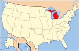
Location of Berrien County in Michigan
This is a list of the National Register of Historic Places listings in Berrien County, Michigan.
This is intended to be a complete list of the properties and districts on the National Register of Historic Places in Berrien County, Michigan, United States. Latitude and longitude coordinates are provided for many National Register properties and districts; these locations may be seen together in a Google map.[1]
There are 30 properties and districts listed on the National Register in the county.
- This National Park Service list is complete through NPS recent listings posted May 1, 2015.[2]
Current listings
| [3] | Name on the Register[4] | Image | Date listed[5] | Location | City or town | Description |
|---|---|---|---|---|---|---|
| 1 | Avery Road-Galien River Bridge | _01.JPG) |
(#99001577) |
Avery Rd. over the Galien River 41°52′27″N 86°33′17″W / 41.874167°N 86.554722°W |
Weesaw Township | |
| 2 | Berrien Springs Courthouse | 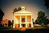 |
(#70000265) |
Corner of Union and Cass Sts. 41°57′27″N 86°20′28″W / 41.9575°N 86.341111°W |
Berrien Springs | |
| 3 | Blossomland Bridge | 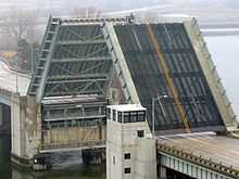 |
(#99001576) |
M-63 over the St. Joseph River 42°06′45″N 86°28′40″W / 42.1125°N 86.477778°W |
St. Joseph | |
| 4 | Buchanan Downtown Historic District | 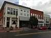 |
(#09000678) |
Front Street, between 117 West and 256 East; parts of Main Street, between 108 and 210-212; and 114 N. Oak Street 41°49′39″N 86°21′37″W / 41.8275°N 86.360278°W |
Buchanan | |
| 5 | Buchanan North and West Neighborhoods Historic District | Upload image | (#11000863) |
Roughly bounded by Main, 4th, Chippewa, W. Front, S. Detroit, Chicago, Clark, Roe, and Charles Sts. 41°49′42″N 86°21′54″W / 41.828378°N 86.36495°W |
Buchanan | |
| 6 | Henry A. Chapin House | 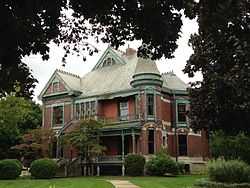 |
(#81000304) |
508 E. Main St. 41°49′45″N 86°15′12″W / 41.829167°N 86.253333°W |
Niles | |
| 7 | Rock S. Edwards Farmstead | Upload image | (#95000868) |
3503 Edwards Rd. 42°03′13″N 86°22′21″W / 42.053611°N 86.3725°W |
Sodus Township | |
| 8 | Fidelity Building | 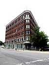 |
(#02000042) |
162 Pipestone St. 42°06′52″N 86°27′15″W / 42.114444°N 86.454167°W |
Benton Harbor | |
| 9 | Fort St. Joseph Site | 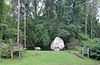 |
(#73000944) |
Bond St. along the St. Joseph River[6] 41°48′54″N 86°15′39″W / 41.815000°N 86.260833°W |
Niles | |
| 10 | Lakeside Inn | 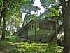 |
(#09000521) |
15251 Lakeshore Rd. 41°50′49″N 86°40′32″W / 41.846908°N 86.675422°W |
Lakeside | |
| 11 | Ring Lardner House |  |
(#72000595) |
519 Bond St. 41°49′39″N 86°15′17″W / 41.8275°N 86.254722°W |
Niles | |
| 12 | Mary's City of David | Upload image | (#09000201) |
1158 E. Britain Ave. 42°06′32″N 86°25′51″W / 42.108783°N 86.430797°W |
Benton Charter Township | |
| 13 | Moccasin Bluff Site |  |
(#77000710) |
Address Restricted |
Buchanan | |
| 14 | Niles Downtown Historic District |  |
(#07000568) |
Sycamore, Main, and Cedar between Front and 5th 41°49′47″N 86°15′22″W / 41.829722°N 86.256111°W |
Niles | |
| 15 | Niles Railroad Depot | 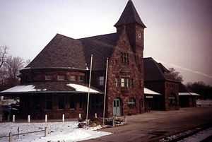 |
(#09000085) |
598 Dey St. 41°50′14″N 86°15′08″W / 41.837222°N 86.252222°W |
Niles | |
| 16 | Ninth District Lighthouse Depot | 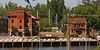 |
(#93001348) |
128 N. Pier 42°06′51″N 86°29′09″W / 42.114167°N 86.485833°W |
St. Joseph | |
| 17 | North Watervliet Road-Paw Paw Lake Outlet Bridge | 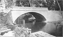 |
(#99001575) |
N. Watervliet Rd. over Paw Paw Lake outlet 42°12′28″N 86°15′00″W / 42.207778°N 86.25°W |
Watervliet Township | |
| 18 | Old Berrien County Courthouse Complex | Upload image | (#82004941) |
Roughly bounded by Cass, Kimmel, Madison, and Union Sts. 41°56′53″N 86°20′28″W / 41.948056°N 86.341111°W |
Berrien Springs | |
| 19 | Old US Post Office | 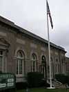 |
(#85002152) |
322 E. Main St. 41°49′46″N 86°16′02″W / 41.829444°N 86.267222°W |
Niles | |
| 20 | Paine Bank | 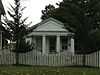 |
(#73000945) |
1008 Oak St. 41°49′35″N 86°14′50″W / 41.826389°N 86.247222°W |
Niles | |
| 21 | Wendell P. and Harriet Rounds Robbins House | Upload image | (#07000385) |
680 Pipestone St. 42°06′17″N 86°26′38″W / 42.104722°N 86.443889°W |
Benton Harbor | |
| 22 | Sandburg House | |
(#72001470) |
Address Restricted |
Harbert | |
| 23 | Shiloh House | 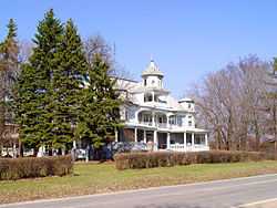 |
(#72000594) |
Britain Rd. 42°06′03″N 86°25′57″W / 42.100833°N 86.4325°W |
Benton Harbor | |
| 24 | Snow Flake Motel | 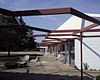 |
(#98000270) |
3822 Red Arrow Highway 42°02′55″N 86°30′56″W / 42.048611°N 86.515556°W |
Lincoln Township | Building demolished March 27, 2006[7] |
| 25 | South Berrien Center Union Church and Cemetery | 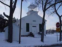 |
(#02001506) |
10408 M-140 41°55′46″N 86°16′19″W / 41.929444°N 86.271944°W |
Berrien | |
| 26 | St. Joseph North Pier Inner and Outer Lights |  |
(#05001211) |
On the north pier of the mouth of the St. Joseph River, 0.9 mi (1.4 km) west of the M-63 bridge 42°06′57″N 86°29′32″W / 42.115833°N 86.492222°W |
St. Joseph | |
| 27 | Union Block | 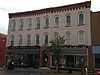 |
(#07000746) |
114 E. Front St. 41°49′37″N 86°21′38″W / 41.826944°N 86.360556°W |
Buchanan | |
| 28 | Union Meat Market | 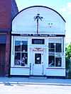 |
(#72000596) |
14 S. Elm St. 41°47′57″N 86°36′42″W / 41.799167°N 86.611667°W |
Three Oaks | |
| 29 | Warren Featherbone Company Office Building | 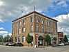 |
(#86000117) |
3 N. Elm St. 41°48′05″N 86°36′38″W / 41.801389°N 86.610556°W |
Three Oaks | |
| 30 | Zinc Collar Pad Company Building | 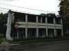 |
(#09000472) |
304 S. Oak St. 41°49′30″N 86°21′40″W / 41.82489°N 86.36111°W |
Buchanan |
See also
| Wikimedia Commons has media related to National Register of Historic Places in Berrien County, Michigan. |
- List of National Historic Landmarks in Michigan
- National Register of Historic Places listings in Michigan
- List of Michigan State Historic Sites in Berrien County, Michigan
References
- ↑ The latitude and longitude information provided in this table was derived originally from the National Register Information System, which has been found to be fairly accurate for about 99% of listings. For about 1% of NRIS original coordinates, experience has shown that one or both coordinates are typos or otherwise extremely far off; some corrections may have been made. A more subtle problem causes many locations to be off by up to 150 yards, depending on location in the country: most NRIS coordinates were derived from tracing out latitude and longitudes off of USGS topographical quadrant maps created under the North American Datum of 1927, which differs from the current, highly accurate WGS84 GPS system used by most on-line maps. Chicago is about right, but NRIS longitudes in Washington are higher by about 4.5 seconds, and are lower by about 2.0 seconds in Maine. Latitudes differ by about 1.0 second in Florida. Some locations in this table may have been corrected to current GPS standards.
- ↑ "National Register of Historic Places: Weekly List Actions". National Park Service, United States Department of the Interior. Retrieved on May 1, 2015.
- ↑ Numbers represent an ordering by significant words. Various colorings, defined here, differentiate National Historic Landmarks and historic districts from other NRHP buildings, structures, sites or objects.
- ↑ "National Register Information System". National Register of Historic Places. National Park Service. 2008-04-24.
- ↑ The eight-digit number below each date is the number assigned to each location in the National Register Information System database, which can be viewed by clicking the number.
- ↑ Nassaney, Michael S., et al. "The Search for Fort St. Joseph (1691-1781) in Niles, Michigan". Midcontinental Journal of Archaeology 28.2 (2003): 107-144: 122.
- ↑ "Demolition of Snowflake Motel begins". The Herald-Palladium. 2006-03-28. p. A1. Retrieved 2012-11-20.
| ||||||||||||

| |||||||||||||||||||||||||||||||||||||