| [3] |
Name on the Register[4] |
Image |
Date listed[5] |
Location |
City or town |
Description |
|---|
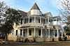
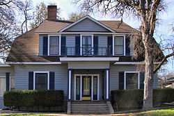
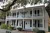
| 1 |
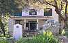
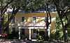
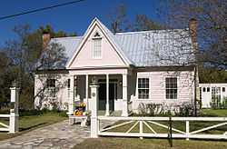
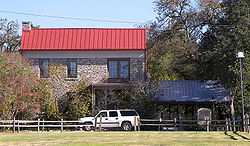
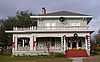
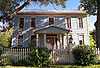
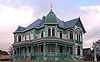
Anderson House and Store |
|
01983-04-05-0000April 5, 1983
(#83003076) |
Main St.
30°56′46″N 97°32′12″W / 30.946111°N 97.536667°W / 30.946111; -97.536667 (Anderson House and Store) |
Salado |
|
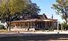
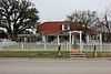
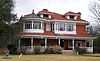
| 2 |
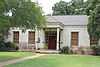
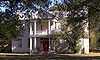
Armstrong-Adams House |
|
01983-04-05-0000April 5, 1983
(#83003077) |
Main St. and Thomas Arnold Rd.
30°56′49″N 97°32′14″W / 30.946944°N 97.537222°W / 30.946944; -97.537222 (Armstrong-Adams House) |
Salado |
|
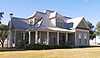
| 3 |
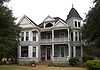
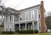
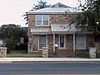
F. K. and Mary Austin House |
Upload image |
01990-12-26-0000December 26, 1990
(#90001891) |
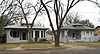
702 N. Penelope St.
31°03′44″N 97°27′35″W / 31.062222°N 97.459722°W / 31.062222; -97.459722 (F. K. and Mary Austin House) |
Belton |
|
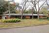
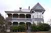
| 4 |
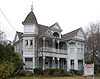
Ele Baggett House |
|
01990-12-26-0000December 26, 1990
(#90001882) |
1019 N. Main St.
31°03′57″N 97°27′36″W / 31.065833°N 97.46°W / 31.065833; -97.46 (Ele Baggett House) |
Belton |
|
| 5 |
Silas and Ellen Baggett House |
|
01990-12-26-0000December 26, 1990
(#90001881) |
1018 N. Main St.
31°03′58″N 97°27′38″W / 31.066111°N 97.460556°W / 31.066111; -97.460556 (Silas and Ellen Baggett House) |
Belton |
|
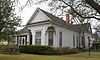
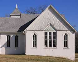
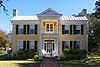
| 6 |
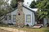
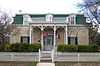
George Washington Baines House |
|
01983-04-05-0000April 5, 1983
(#83003078) |
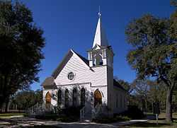
Royal St.
30°56′31″N 97°31′59″W / 30.941944°N 97.533056°W / 30.941944; -97.533056 (George Washington Baines House) |
Salado |
|
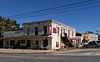
| 7 |
Barbee-Berry Mercantile Building |
|
01984-08-22-0000August 22, 1984
(#84001571) |
Main and Royal St.
30°56′35″N 97°32′13″W / 30.943056°N 97.536944°W / 30.943056; -97.536944 (Barbee-Berry Mercantile Building) |
Salado |
|
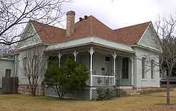
| 8 |
Barclay-Bryan House |
|
01984-05-10-0000May 10, 1984
(#84001572) |
804 S. 25th St.
31°05′32″N 97°21′28″W / 31.092222°N 97.357778°W / 31.092222; -97.357778 (Barclay-Bryan House) |
Temple |
|
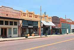
| 9 |
Bartlett Commercial Historic District |
|
01980-09-30-0000September 30, 1980
(#80004076) |
E. Clark St.
30°47′42″N 97°25′37″W / 30.795°N 97.426944°W / 30.795; -97.426944 (Bartlett Commercial Historic District) |
Bartlett |
|
| 10 |
Barton House |
|
01983-04-05-0000April 5, 1983
(#83003079) |
Main St.
30°56′51″N 97°32′07″W / 30.9475°N 97.535278°W / 30.9475; -97.535278 (Barton House) |
Salado |
|
| 11 |
Baylor Female College Historic District |
|
01990-12-26-0000December 26, 1990
(#90001869) |
Bounded by King, College and W. Ninth Sts.
31°04′01″N 97°27′50″W / 31.066944°N 97.463889°W / 31.066944; -97.463889 (Baylor Female College Historic District) |
Belton |
6 buildings
|
| 12 |
William Beamer House |
Upload image |
01990-12-26-0000December 26, 1990
(#90001875) |
1202 S. Beal St.
31°02′41″N 97°27′52″W / 31.044722°N 97.464444°W / 31.044722; -97.464444 (William Beamer House) |
Belton |
|
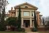
| 13 |
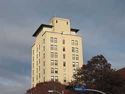
Bell County Courthouse |
|
01976-12-12-0000December 12, 1976
(#76002004) |
Public Sq.
31°03′21″N 97°27′49″W / 31.055833°N 97.463611°W / 31.055833; -97.463611 (Bell County Courthouse) |
Belton |
|
| 14 |
Belton Academy |
Upload image |
01990-12-26-0000December 26, 1990
(#90001937) |
404 E. Ninth St.
31°03′49″N 97°27′28″W / 31.063611°N 97.457778°W / 31.063611; -97.457778 (Belton Academy) |
Belton |
aka Charles Wedemeyer House
|
| 15 |
Belton Commercial Historic District |
Upload image |
01990-12-26-0000December 26, 1990
(#90001868) |
Roughly bounded by Nolan Valley Rd., Penelope St. and Nolan Cr..
31°03′23″N 97°27′45″W / 31.056389°N 97.4625°W / 31.056389; -97.4625 (Belton Commercial Historic District) |
Belton |
46 buildings
|
| 16 |
Belton Farmers' Gin Coop |
|
01990-12-26-0000December 26, 1990
(#90001870) |
219 S. East Ave., Building 4
31°03′18″N 97°27′45″W / 31.055°N 97.4625°W / 31.055; -97.4625 (Belton Farmers' Gin Coop) |
Belton |
|
| 17 |
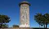
Belton Standpipe |
|
01990-12-26-0000December 26, 1990
(#90001900) |
NW of jct. of TX 317 & I-35
31°02′58″N 97°28′12″W / 31.049444°N 97.47°W / 31.049444; -97.47 (Belton Standpipe) |
Belton |
|
| 18 |
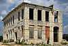
Belton Yarn Mill |
|
01990-12-26-0000December 26, 1990
(#90001899) |
805 E. Fourth St.
31°03′28″N 97°27′14″W / 31.0579°N 97.4539°W / 31.0579; -97.4539 (Belton Yarn Mill) |
Belton |
|
| 19 |
T. Hamp and Beulah Birdwell House |
Upload image |
01990-12-26-0000December 26, 1990
(#90001896) |
503 N. Wall
31°03′37″N 97°27′32″W / 31.060278°N 97.458889°W / 31.060278; -97.458889 (T. Hamp and Beulah Birdwell House) |
Belton |
|
| 20 |
R. F. and Lena Burford House |
|
01990-12-26-0000December 26, 1990
(#90001893) |
920 N. Penelope St.
31°03′01″N 97°27′33″W / 31.050278°N 97.459167°W / 31.050278; -97.459167 (R. F. and Lena Burford House) |
Belton |
|
| 21 |
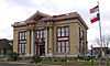
Carnegie Public Library |
|
01985-03-04-0000March 4, 1985
(#85000473) |
201 N. Main St.
31°03′27″N 97°27′48″W / 31.0575°N 97.463333°W / 31.0575; -97.463333 (Carnegie Public Library) |
Belton |
|
| 22 |
Cornelison House |
|
01990-12-26-0000December 26, 1990
(#90001886) |
1102 N. Pearl St.
31°04′01″N 97°27′41″W / 31.066944°N 97.461389°W / 31.066944; -97.461389 (Cornelison House) |
Belton |
|
| 23 |
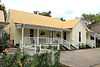
Davis House |
|
01983-04-05-0000April 5, 1983
(#83003080) |
Main St.
30°56′41″N 97°32′11″W / 30.944722°N 97.536389°W / 30.944722; -97.536389 (Davis House) |
Salado |
|
| 24 |
Joel Elliott House |
Upload image |
01990-12-26-0000December 26, 1990
(#90001876) |
716 N. College St.
31°03′50″N 97°27′51″W / 31.063889°N 97.464167°W / 31.063889; -97.464167 (Joel Elliott House) |
Belton |
|
| 25 |
Ferguson House |
|
01978-12-08-0000December 8, 1978
(#78002888) |
518 N. 7th St.
31°06′12″N 97°20′36″W / 31.103333°N 97.343472°W / 31.103333; -97.343472 (Ferguson House) |
Temple |
|
| 26 |
James A. Ferguson House |
|
01990-12-26-0000December 26, 1990
(#90001874) |
1123 N. Beal St.
31°03′57″N 97°27′19″W / 31.065833°N 97.455278°W / 31.065833; -97.455278 (James A. Ferguson House) |
Belton |
|
| 27 |
James E. and Miriam Ferguson House |
|
01990-12-26-0000December 26, 1990
(#90001889) |
604 N. Penelope St.
31°03′41″N 97°27′37″W / 31.061389°N 97.460139°W / 31.061389; -97.460139 (James E. and Miriam Ferguson House) |
Belton |
|
| 28 |
First Christian Church Parsonage |
|
01990-12-26-0000December 26, 1990
(#90001890) |
608 N. Penelope St.
31°03′43″N 97°27′36″W / 31.061944°N 97.46°W / 31.061944; -97.46 (First Christian Church Parsonage) |
Belton |
|
| 29 |
Fowler House |
|
01983-04-05-0000April 5, 1983
(#83003081) |
Main St.
30°57′30″N 97°31′58″W / 30.958333°N 97.532778°W / 30.958333; -97.532778 (Fowler House) |
Salado |
|
| 30 |
Dr. Jacob Moore Frazier House |
Upload image |
01990-12-26-0000December 26, 1990
(#90001897) |
618 N. Wall
31°03′42″N 97°27′32″W / 31.061667°N 97.458889°W / 31.061667; -97.458889 (Dr. Jacob Moore Frazier House) |
Belton |
|
| 31 |
Gray Rental Houses |
|
01990-12-26-0000December 26, 1990
(#90001934) |
702-708 N. Pearl St.
31°03′48″N 97°27′46″W / 31.063333°N 97.462778°W / 31.063333; -97.462778 (Gray Rental Houses) |
Belton |
3 buildings
|
| 32 |
Capt. Robert Halley House |
|
01983-04-05-0000April 5, 1983
(#83003082) |
Main St.
30°57′15″N 97°31′57″W / 30.954167°N 97.5325°W / 30.954167; -97.5325 (Capt. Robert Halley House) |
Salado |
|
| 33 |
John P. Hammersmith House |
Upload image |
01990-12-26-0000December 26, 1990
(#90001883) |
520 S. Main St.
31°03′10″N 97°27′56″W / 31.052778°N 97.465556°W / 31.052778; -97.465556 (John P. Hammersmith House) |
Belton |
|
| 34 |
Capt. Andrew Jackson Harris House |
Upload image |
01990-12-26-0000December 26, 1990
(#90001871) |
1001 W. Tenth Ave.
31°04′02″N 97°28′09″W / 31.067222°N 97.469167°W / 31.067222; -97.469167 (Capt. Andrew Jackson Harris House) |
Belton |
|
| 35 |
Hendrickson-Caskey House |
|
01995-02-10-0000February 10, 1995
(#95000054) |
Center Circle
30°56′42″N 97°31′54″W / 30.945°N 97.531528°W / 30.945; -97.531528 (Hendrickson-Caskey House) |
Salado |
|
| 36 |
House at 402 N. East St. |
Upload image |
01990-12-26-0000December 26, 1990
(#90001878) |
402 N. East St.
31°03′33″N 97°27′44″W / 31.059167°N 97.462222°W / 31.059167; -97.462222 (House at 402 N. East St.) |
Belton |
|
| 37 |
House at 730 N. Beal St. |
Upload image |
01990-12-26-0000December 26, 1990
(#90001936) |
730 N. Beal St.
31°03′45″N 97°27′26″W / 31.0625°N 97.457222°W / 31.0625; -97.457222 (House at 730 N. Beal St.) |
Belton |
|
| 38 |
Dr. Taylor Hudson House |
|
01990-12-26-0000December 26, 1990
(#90001879) |
324 N. Main St.
31°03′33″N 97°27′48″W / 31.059167°N 97.463333°W / 31.059167; -97.463333 (Dr. Taylor Hudson House) |
Belton |
|
| 39 |
James House |
Upload image |
01990-12-26-0000December 26, 1990
(#90001873) |
805 N. Beal St.
31°03′48″N 97°27′22″W / 31.063333°N 97.456111°W / 31.063333; -97.456111 (James House) |
Belton |
|
| 40 |
Killeen Downtown Historic District |
|
02014-03-31-0000March 31, 2014
(#14000098) |
Roughly bounded by Avenue A, Santa Fe Plaza, North 4th & North 8th Streets
31°07′19″N 97°43′38″W / 31.121839°N 97.727285°W / 31.121839; -97.727285 (Killeen Downtown Historic District) |
Killeen |
|
| 41 |
L. B. Kinchion House |
Upload image |
01990-12-26-0000December 26, 1990
(#90001887) |
702 S. Pearl St.
31°03′04″N 97°27′58″W / 31.051111°N 97.466111°W / 31.051111; -97.466111 (L. B. Kinchion House) |
Belton |
|
| 42 |
Kyle Hotel |
|
01993-08-05-0000August 5, 1993
(#93000772) |
111 Main St.
31°05′54″N 97°20′26″W / 31.098333°N 97.340556°W / 31.098333; -97.340556 (Kyle Hotel) |
Temple |
|
| 43 |
Walter J. Lee House |
Upload image |
01990-12-26-0000December 26, 1990
(#90001877) |
804 N. College St.
31°03′52″N 97°27′49″W / 31.064444°N 97.463611°W / 31.064444; -97.463611 (Walter J. Lee House) |
Belton |
|
| 44 |
George and Martha McWhirter House |
|
01990-12-26-0000December 26, 1990
(#90001884) |
400 N. Pearl St.
31°03′36″N 97°27′50″W / 31.06°N 97.463889°W / 31.06; -97.463889 (George and Martha McWhirter House) |
Belton |
|
| 45 |
V. R. Means House |
|
01990-12-26-0000December 26, 1990
(#90001938) |
609 E. 14th St.
31°04′04″N 97°27′05″W / 31.067778°N 97.451389°W / 31.067778; -97.451389 (V. R. Means House) |
Belton |
|
| 46 |
J. Z. Miller House |
Upload image |
01990-12-26-0000December 26, 1990
(#90001892) |
804 N. Penelope St.
31°03′47″N 97°27′33″W / 31.063056°N 97.459167°W / 31.063056; -97.459167 (J. Z. Miller House) |
Belton |
|
| 47 |
Miller-Curtis House |
|
01983-04-07-0000April 7, 1983
(#83003083) |
1004 N. Main St.
31°03′56″N 97°27′38″W / 31.065556°N 97.460694°W / 31.065556; -97.460694 (Miller-Curtis House) |
Belton |
aka Curtis Mansion
|
| 48 |
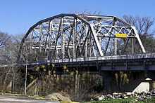
Missouri, Kansas & Texas Railroad Bridge at the Leon River |
Upload image |
01990-12-26-0000December 26, 1990
(#90001898) |
Across the Leon R. at Taylor's Valley Rd.
31°03′44″N 97°26′35″W / 31.062222°N 97.443056°W / 31.062222; -97.443056 (Missouri, Kansas & Texas Railroad Bridge at the Leon River) |
Belton |
|
| 49 |
Morey House |
|
01990-12-26-0000December 26, 1990
(#90001880) |
328 N. Main St.
31°03′33″N 97°27′47″W / 31.059167°N 97.463056°W / 31.059167; -97.463056 (Morey House) |
Belton |
|
| 50 |
Mount Zion United Methodist Church |
|
01990-12-26-0000December 26, 1990
(#90001872) |
218 Alexander St.
31°03′35″N 97°27′57″W / 31.05973°N 97.4658°W / 31.05973; -97.4658 (Mount Zion United Methodist Church) |
Belton |
|
| 51 |
Robert Naismith House |
Upload image |
01990-12-26-0000December 26, 1990
(#90001888) |
440 N. Penelope St.
31°03′36″N 97°27′39″W / 31.06°N 97.460833°W / 31.06; -97.460833 (Robert Naismith House) |
Belton |
|
| 52 |
Norton-Orgain House |
|
01992-03-25-0000March 25, 1992
(#92000185) |
Main St.
30°56′50″N 97°32′11″W / 30.947222°N 97.536389°W / 30.947222; -97.536389 (Norton-Orgain House) |
Salado |
|
| 53 |
Old St. Luke's Episcopal Church |
|
01974-01-17-0000January 17, 1974
(#74002056) |
438 N. Wall St.
31°03′36″N 97°27′33″W / 31.06°N 97.4593°W / 31.06; -97.4593 (Old St. Luke's Episcopal Church) |
Belton |
|
| 54 |
Arthur Potts House |
Upload image |
01990-12-26-0000December 26, 1990
(#90001895) |
445 N. Wall
31°03′35″N 97°27′33″W / 31.059722°N 97.459167°W / 31.059722; -97.459167 (Arthur Potts House) |
Belton |
|
| 55 |
Col. Elijah Sterling Clack Robertson Plantation |
|
01983-04-05-0000April 5, 1983
(#83003084) |
I-35
30°56′32″N 97°32′34″W / 30.942222°N 97.542778°W / 30.942222; -97.542778 (Col. Elijah Sterling Clack Robertson Plantation) |
Salado |
|
| 56 |
Maj. A. J. Rose House |
|
01978-05-22-0000May 22, 1978
(#78002887) |
Wm. Rose Way and Royal St.
30°56′26″N 97°31′46″W / 30.940556°N 97.529444°W / 30.940556; -97.529444 (Maj. A. J. Rose House) |
Salado |
|
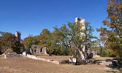
| 57 |
Salado College Archeological Site |
|
01985-03-01-0000March 1, 1985
(#85000403) |
Main St & College Hill
30°56′30″N 97°32′14″W / 30.941667°N 97.537222°W / 30.941667; -97.537222 (Salado College Archeological Site) |
Salado |
41BL241
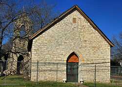
|
| 58 |
Salado United Methodist Church |
|
01984-08-22-0000August 22, 1984
(#84001573) |
Off Royal St.
30°56′30″N 97°31′44″W / 30.941667°N 97.528889°W / 30.941667; -97.528889 (Salado United Methodist Church) |
Salado |
Built in 1890. Moved from its original location in 2005.
|
| 59 |
Stagecoach Inn |
|
01983-04-05-0000April 5, 1983
(#83003085) |
Main and Front Sts.
30°56′31″N 97°32′15″W / 30.941944°N 97.5375°W / 30.941944; -97.5375 (Stagecoach Inn) |
Salado |
|
| 60 |
State Highway 53 Bridge at the Leon River |
|
01996-10-10-0000October 10, 1996
(#96001119) |
FM 817, 2.5 mi (4.0 km). E of jct. with FM 93
31°03′59″N 97°26′33″W / 31.066389°N 97.4425°W / 31.066389; -97.4425 (State Highway 53 Bridge at the Leon River) |
Belton |
|
| 61 |
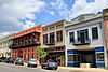
Temple Commercial Historic District |
|
02005-10-28-0000October 28, 2005
(#05001192) |
Roughly bounded by French Av., 3rd St., Av. D & 6th St.
31°05′53″N 97°20′28″W / 31.098056°N 97.341111°W / 31.098056; -97.341111 (Temple Commercial Historic District) |
Temple |
111 buildings
|
| 62 |
Levi Tenney House |
|
01983-04-05-0000April 5, 1983
(#83003086) |
Pace Park Dr.
30°56′49″N 97°32′08″W / 30.946944°N 97.535556°W / 30.946944; -97.535556 (Levi Tenney House) |
Salado |
|
| 63 |
Twelve Oaks |
|
01983-04-05-0000April 5, 1983
(#83003088) |
Center Cirlce
30°56′45″N 97°31′55″W / 30.945833°N 97.531944°W / 30.945833; -97.531944 (Twelve Oaks) |
Salado |
|
| 64 |
Tyler House |
|
01983-04-05-0000April 5, 1983
(#83003087) |
Main St.
30°56′45″N 97°32′15″W / 30.945833°N 97.5375°W / 30.945833; -97.5375 (Tyler House) |
Salado |
|
| 65 |
W. J. Venable House |
Upload image |
01990-12-26-0000December 26, 1990
(#90001894) |
426 N. Wall
31°03′32″N 97°27′34″W / 31.058889°N 97.459444°W / 31.058889; -97.459444 (W. J. Venable House) |
Belton |
|
| 66 |
Vickrey House |
|
01983-04-05-0000April 5, 1983
(#83003089) |
Main St.
30°57′04″N 97°32′11″W / 30.951111°N 97.536389°W / 30.951111; -97.536389 (Vickrey House) |
Salado |
|
| 67 |
H. A. and Helena Ware House |
Upload image |
01990-12-26-0000December 26, 1990
(#90001885) |
401 N. Pearl St.
31°03′35″N 97°27′48″W / 31.059722°N 97.463333°W / 31.059722; -97.463333 (H. A. and Helena Ware House) |
Belton |
|
| 68 |
White-Aiken House |
|
01983-04-05-0000April 5, 1983
(#83003090) |
I-35
30°57′36″N 97°31′58″W / 30.96°N 97.532778°W / 30.96; -97.532778 (White-Aiken House) |
Salado |
|
| 69 |
Ralph and Sunny Wilson Sr. House |
|
01998-11-25-0000November 25, 1998
(#98001374) |
1714 S. 61st. St.
31°05′17″N 97°22′50″W / 31.088056°N 97.380556°W / 31.088056; -97.380556 (Ralph and Sunny Wilson Sr. House) |
Temple |
|
.jpg)

.jpg)