| [4] |
Name on the Register[5] |
Image |
Date listed[6] |
Location |
City or town |
Description |
|---|
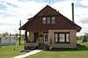
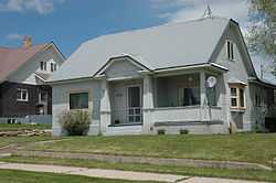
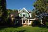
| 1 |
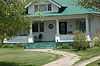
Ezra Allred Bungalow |
|
01982-11-18-0000November 18, 1982
(#82000258) |
95 W. Center St.
42°13′36″N 111°24′10″W / 42.226667°N 111.402778°W / 42.226667; -111.402778 (Ezra Allred Bungalow) |
Paris |
|
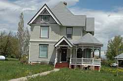
| 2 |
Ezra Allred Cottage |
Upload image |
01982-11-18-0000November 18, 1982
(#82000259) |
159 N. Main St.
42°13′50″N 111°24′03″W / 42.230556°N 111.400833°W / 42.230556; -111.400833 (Ezra Allred Cottage) |
Paris |
|
| 3 |
Dr. George Ashley House |
Upload image |
01982-11-18-0000November 18, 1982
(#82000261) |
40 W. 2nd North
42°13′53″N 111°24′06″W / 42.231389°N 111.401667°W / 42.231389; -111.401667 (Dr. George Ashley House) |
Paris |
|
| 4 |
George Ashley, Sr., House |
Upload image |
01982-11-18-0000November 18, 1982
(#82000260) |
W. 2nd North
42°13′54″N 111°24′08″W / 42.231667°N 111.402222°W / 42.231667; -111.402222 (George Ashley, Sr., House) |
Paris |
|
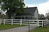
| 5 |
Sam Athay House |
Upload image |
01982-11-18-0000November 18, 1982
(#82004939) |
20 W. 2nd North
42°13′54″N 111°24′04″W / 42.231667°N 111.401111°W / 42.231667; -111.401111 (Sam Athay House) |
Paris |
|
| 6 |
John A. Bagley House |
Upload image |
01978-01-20-0000January 20, 1978
(#78001046) |
155 N. 5th St.
42°19′30″N 111°18′01″W / 42.325°N 111.300278°W / 42.325; -111.300278 (John A. Bagley House) |
Montpelier |
|
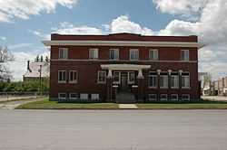
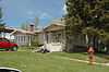
| 7 |
Bear Lake County Courthouse |
|
01977-10-07-0000October 7, 1977
(#77000454) |
7 E. Center St.
42°13′38″N 111°23′59″W / 42.227222°N 111.399722°W / 42.227222; -111.399722 (Bear Lake County Courthouse) |
Paris |
|
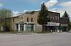
| 8 |
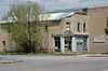
Bear Lake Market |
|
01982-11-18-0000November 18, 1982
(#82000262) |
5 N. Main St.
42°13′38″N 111°24′02″W / 42.227222°N 111.400556°W / 42.227222; -111.400556 (Bear Lake Market) |
Paris |
|
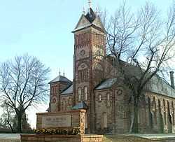
| 9 |
Bear Lake Stake Tabernacle |
|
01972-12-08-0000December 8, 1972
(#72000436) |
109 S. Main St.
42°13′33″N 111°24′01″W / 42.225833°N 111.400278°W / 42.225833; -111.400278 (Bear Lake Stake Tabernacle) |
Paris |
|
| 10 |
Beck Barns and Automobile Storage |
Upload image |
01982-11-18-0000November 18, 1982
(#82000263) |
Center St.
42°13′35″N 111°24′05″W / 42.226389°N 111.401389°W / 42.226389; -111.401389 (Beck Barns and Automobile Storage) |
Paris |
|
| 11 |
Bishop West Barn |
Upload image |
01982-11-18-0000November 18, 1982
(#82000264) |
W. 2nd South
42°13′20″N 111°24′13″W / 42.222222°N 111.403611°W / 42.222222; -111.403611 (Bishop West Barn) |
Paris |
|
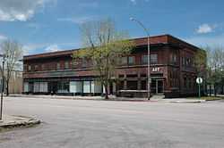
| 12 |
Browning Block |
|
01982-11-18-0000November 18, 1982
(#82000265) |
Main and Center Sts.
42°13′36″N 111°24′02″W / 42.226667°N 111.400556°W / 42.226667; -111.400556 (Browning Block) |
Paris |
|
| 13 |
Budge Cottage |
Upload image |
01982-11-18-0000November 18, 1982
(#82000266) |
Center St.
42°13′38″N 111°24′17″W / 42.227222°N 111.404722°W / 42.227222; -111.404722 (Budge Cottage) |
Paris |
|
| 14 |
Alfred Budge House |
Upload image |
01982-11-18-0000November 18, 1982
(#82000267) |
N. 1st West at W. 1st North
42°13′44″N 111°24′14″W / 42.228889°N 111.403889°W / 42.228889; -111.403889 (Alfred Budge House) |
Paris |
|
| 15 |
Julia Budge House |
Upload image |
01982-11-18-0000November 18, 1982
(#82000268) |
57 W. 1st North
42°13′43″N 111°24′06″W / 42.228611°N 111.401667°W / 42.228611; -111.401667 (Julia Budge House) |
Paris |
|
| 16 |
Taft Budge Bungalow |
|
01983-04-13-0000April 13, 1983
(#83000260) |
86 W. Center St.
42°13′38″N 111°24′08″W / 42.227222°N 111.402222°W / 42.227222; -111.402222 (Taft Budge Bungalow) |
Paris |
|
| 17 |
Russell Clayton Bungalow |
Upload image |
01983-04-13-0000April 13, 1983
(#83000261) |
147 E. Center St.
42°13′38″N 111°23′46″W / 42.227222°N 111.396111°W / 42.227222; -111.396111 (Russell Clayton Bungalow) |
Paris |
|
| 18 |
Cole House |
Upload image |
01982-11-18-0000November 18, 1982
(#82000269) |
Southwest of Paris
42°13′00″N 111°24′35″W / 42.216667°N 111.409722°W / 42.216667; -111.409722 (Cole House) |
Paris |
|
| 19 |
James Collings, Jr., House |
Upload image |
01982-11-18-0000November 18, 1982
(#82001888) |
South of Paris on U.S. Route 89
42°13′00″N 111°23′59″W / 42.216667°N 111.399722°W / 42.216667; -111.399722 (James Collings, Jr., House) |
Paris |
|
| 20 |
Joseph Cook House |
Upload image |
01982-11-18-0000November 18, 1982
(#82000270) |
63 W. 2nd South
42°13′20″N 111°24′08″W / 42.222222°N 111.402222°W / 42.222222; -111.402222 (Joseph Cook House) |
Paris |
|
| 21 |
E. F. Davis House |
Upload image |
01982-11-18-0000November 18, 1982
(#82000271) |
10 W. 2nd North
42°13′54″N 111°24′03″W / 42.231667°N 111.400833°W / 42.231667; -111.400833 (E. F. Davis House) |
Paris |
|
| 22 |
Georgetown Relief Society Hall |
Upload image |
01998-09-18-0000September 18, 1998
(#98001171) |
161 3rd NW. St.
42°28′27″N 111°22′10″W / 42.474167°N 111.369444°W / 42.474167; -111.369444 (Georgetown Relief Society Hall) |
Georgetown |
|
| 23 |
John Grimmett, Jr., House and Outbuildings |
Upload image |
01983-04-13-0000April 13, 1983
(#83000262) |
135 W. 2nd North
42°13′51″N 111°24′14″W / 42.230833°N 111.403889°W / 42.230833; -111.403889 (John Grimmett, Jr., House and Outbuildings) |
Paris |
|
| 24 |
Orson Grimmett Bungalow |
Upload image |
01983-04-13-0000April 13, 1983
(#83000263) |
28 W. 2nd North
42°13′54″N 111°24′05″W / 42.231667°N 111.401389°W / 42.231667; -111.401389 (Orson Grimmett Bungalow) |
Paris |
|
| 25 |
Grunder Cabin and Outbuildings |
Upload image |
01982-11-18-0000November 18, 1982
(#82000272) |
E. 1st North
42°13′45″N 111°23′31″W / 42.229167°N 111.391944°W / 42.229167; -111.391944 (Grunder Cabin and Outbuildings) |
Paris |
|
| 26 |
Hoffman Barn |
Upload image |
01982-11-18-0000November 18, 1982
(#82000273) |
N. 2nd East
42°13′48″N 111°23′35″W / 42.23°N 111.393056°W / 42.23; -111.393056 (Hoffman Barn) |
Paris |
|
| 27 |
Walter Hoge House |
Upload image |
01982-11-18-0000November 18, 1982
(#82000274) |
Center and N. 1st East
42°13′38″N 111°23′51″W / 42.227222°N 111.3975°W / 42.227222; -111.3975 (Walter Hoge House) |
Paris |
|
| 28 |
Hotel Paris |
|
01982-11-18-0000November 18, 1982
(#82000275) |
7 S. Main St.
42°13′36″N 111°23′59″W / 42.226667°N 111.399722°W / 42.226667; -111.399722 (Hotel Paris) |
Paris |
|
| 29 |
Amos Hulme Barn |
Upload image |
01982-11-18-0000November 18, 1982
(#82000276) |
N. 1st East
42°13′48″N 111°23′51″W / 42.23°N 111.3975°W / 42.23; -111.3975 (Amos Hulme Barn) |
Paris |
|
| 30 |
Kate Innes House |
Upload image |
01983-04-13-0000April 13, 1983
(#83000264) |
100 E. 2nd South
42°13′20″N 111°23′51″W / 42.222222°N 111.3975°W / 42.222222; -111.3975 (Kate Innes House) |
Paris |
|
| 31 |
Thomas Innes House |
Upload image |
01982-11-18-0000November 18, 1982
(#82000277) |
42 W. 1st South
42°13′30″N 111°24′05″W / 42.225°N 111.401389°W / 42.225; -111.401389 (Thomas Innes House) |
Paris |
|
| 32 |
Jaussi Bungalow |
Upload image |
01982-11-18-0000November 18, 1982
(#82000278) |
170 E. 2nd North
42°13′52″N 111°23′43″W / 42.231111°N 111.395278°W / 42.231111; -111.395278 (Jaussi Bungalow) |
Paris |
|
| 33 |
Keller House and Derrick |
Upload image |
01982-11-18-0000November 18, 1982
(#82001889) |
E. 1st North
42°13′43″N 111°23′38″W / 42.228611°N 111.393889°W / 42.228611; -111.393889 (Keller House and Derrick) |
Paris |
|
| 34 |
Robert Kelsey Bungalow |
Upload image |
01983-04-13-0000April 13, 1983
(#83000265) |
24 E. 2nd South
42°13′20″N 111°23′58″W / 42.222222°N 111.399444°W / 42.222222; -111.399444 (Robert Kelsey Bungalow) |
Paris |
|
| 35 |
Latham Bungalow |
Upload image |
01983-04-13-0000April 13, 1983
(#83000266) |
152 S. 1st East
42°13′26″N 111°23′51″W / 42.223889°N 111.3975°W / 42.223889; -111.3975 (Latham Bungalow) |
Paris |
|
| 36 |
Oren Law House and Outbuildings |
Upload image |
01982-11-18-0000November 18, 1982
(#82000281) |
592 N. Main St.
42°14′28″N 111°23′59″W / 42.241111°N 111.399722°W / 42.241111; -111.399722 (Oren Law House and Outbuildings) |
Paris |
|
| 37 |
LDS Seminary |
|
01982-11-18-0000November 18, 1982
(#82000279) |
Tabernacle Block
42°13′34″N 111°23′56″W / 42.226111°N 111.398889°W / 42.226111; -111.398889 (LDS Seminary) |
Paris |
|
| 38 |
LDS Stake Office Building |
|
01982-11-18-0000November 18, 1982
(#82000280) |
62 S. Main St.
42°13′32″N 111°24′03″W / 42.225556°N 111.400833°W / 42.225556; -111.400833 (LDS Stake Office Building) |
Paris |
|
| 39 |
Lewis Barn |
Upload image |
01982-11-18-0000November 18, 1982
(#82000282) |
W. 2nd North
42°13′52″N 111°24′19″W / 42.231111°N 111.405278°W / 42.231111; -111.405278 (Lewis Barn) |
Paris |
|
| 40 |
Lewis Bungalow |
Upload image |
01983-04-13-0000April 13, 1983
(#83000267) |
W. 2nd North
42°13′54″N 111°24′18″W / 42.231667°N 111.405°W / 42.231667; -111.405 (Lewis Bungalow) |
Paris |
|
| 41 |
Fred Lewis Cottage |
Upload image |
01983-04-13-0000April 13, 1983
(#83000268) |
W. 2nd North
42°13′54″N 111°24′20″W / 42.231667°N 111.405556°W / 42.231667; -111.405556 (Fred Lewis Cottage) |
Paris |
|
| 42 |
J.L. Linvall House and Outbuilding |
Upload image |
01982-11-18-0000November 18, 1982
(#82000283) |
E. 2nd South
42°13′23″N 111°23′38″W / 42.223056°N 111.393889°W / 42.223056; -111.393889 (J.L. Linvall House and Outbuilding) |
Paris |
|
| 43 |
Robb Linvall House |
Upload image |
01982-11-18-0000November 18, 1982
(#82000284) |
Paris Canyon Rd.
42°13′19″N 111°24′37″W / 42.221944°N 111.410278°W / 42.221944; -111.410278 (Robb Linvall House) |
Paris |
|
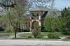
| 44 |
Morris Low Bungalow |
|
01982-11-18-0000November 18, 1982
(#82000285) |
48 W. Center St.
42°13′39″N 111°24′06″W / 42.2275°N 111.401667°W / 42.2275; -111.401667 (Morris Low Bungalow) |
Paris |
|
| 45 |
Montpelier Historic District |
Upload image |
01978-11-16-0000November 16, 1978
(#78001047) |
Washington Ave. and 6th St.
42°19′04″N 111°18′07″W / 42.317778°N 111.301944°W / 42.317778; -111.301944 (Montpelier Historic District) |
Montpelier |
|
| 46 |
Montpelier Odd Fellows Hall |
Upload image |
01978-04-15-0000April 15, 1978
(#78001048) |
843 Washington St.
42°19′02″N 111°18′27″W / 42.317222°N 111.3075°W / 42.317222; -111.3075 (Montpelier Odd Fellows Hall) |
Montpelier |
|
| 47 |
Wilhelmina Nelson House and Cabins |
Upload image |
01976-05-03-0000May 3, 1976
(#76000668) |
U.S. Route 89
42°06′36″N 111°23′15″W / 42.11°N 111.3875°W / 42.11; -111.3875 (Wilhelmina Nelson House and Cabins) |
St. Charles |
|
| 48 |
James Nye House |
Upload image |
01983-04-13-0000April 13, 1983
(#83000269) |
E. 1st South
42°13′38″N 111°23′46″W / 42.227222°N 111.396111°W / 42.227222; -111.396111 (James Nye House) |
Paris |
|
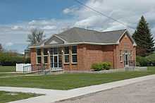
| 49 |
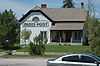
Old LDS Tithing/Paris Post Building |
|
01982-11-18-0000November 18, 1982
(#82000286) |
58 S. Main St.
42°13′33″N 111°24′03″W / 42.225833°N 111.400833°W / 42.225833; -111.400833 (Old LDS Tithing/Paris Post Building) |
Paris |
|
| 50 |
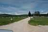
Paris Cemetery |
|
01982-11-18-0000November 18, 1982
(#82000287) |
South of Paris, west of U.S. Route 89
42°12′48″N 111°24′25″W / 42.213333°N 111.406944°W / 42.213333; -111.406944 (Paris Cemetery) |
Paris |
|
| 51 |
Paris Lumber Company Building |
Upload image |
01982-11-18-0000November 18, 1982
(#82000288) |
Main St.
42°13′23″N 111°24′02″W / 42.223056°N 111.400556°W / 42.223056; -111.400556 (Paris Lumber Company Building) |
Paris |
|
| 52 |
Paris Photo Studio |
Upload image |
01982-11-18-0000November 18, 1982
(#82000289) |
W. Center St.
42°13′36″N 111°24′03″W / 42.226667°N 111.400833°W / 42.226667; -111.400833 (Paris Photo Studio) |
Paris |
Formerly attached to the west side of the Browning Block, this building is no longer standing.
|
| 53 |
Paris Public School |
Upload image |
01982-11-18-0000November 18, 1982
(#82000290) |
Main and 1st North Sts.
42°13′43″N 111°23′58″W / 42.228611°N 111.399444°W / 42.228611; -111.399444 (Paris Public School) |
Paris |
|
| 54 |
Pendrey Drug Store Building |
|
01982-11-18-0000November 18, 1982
(#82000291) |
Main and Center Sts.
42°13′38″N 111°24′02″W / 42.227222°N 111.400556°W / 42.227222; -111.400556 (Pendrey Drug Store Building) |
Paris |
|
| 55 |
Arthur Pendrey Cottage |
Upload image |
01982-11-18-0000November 18, 1982
(#82004938) |
193 N. Main St.
42°13′51″N 111°24′02″W / 42.230833°N 111.400556°W / 42.230833; -111.400556 (Arthur Pendrey Cottage) |
Paris |
|
| 56 |
Joe and Zina Pendrey Bungalow |
Upload image |
01983-04-13-0000April 13, 1983
(#83000270) |
N. Main St.
42°13′40″N 111°24′02″W / 42.227778°N 111.400556°W / 42.227778; -111.400556 (Joe and Zina Pendrey Bungalow) |
Paris |
|
| 57 |
Jim Poulson House |
Upload image |
01982-11-18-0000November 18, 1982
(#82000292) |
146 E. 1st North
42°13′44″N 111°23′46″W / 42.228889°N 111.396111°W / 42.228889; -111.396111 (Jim Poulson House) |
Paris |
|
| 58 |
Preston Bungalow |
Upload image |
01983-04-13-0000April 13, 1983
(#83000271) |
W. Center St.
42°13′39″N 111°24′05″W / 42.2275°N 111.401389°W / 42.2275; -111.401389 (Preston Bungalow) |
Paris |
|
| 59 |
Dan Price House |
Upload image |
01982-11-18-0000November 18, 1982
(#82000293) |
W. 1st North and N. 1st West
42°13′46″N 111°24′09″W / 42.229444°N 111.4025°W / 42.229444; -111.4025 (Dan Price House) |
Paris |
|
| 60 |
Fred Price Bungalow |
Upload image |
01983-04-13-0000April 13, 1983
(#83000272) |
N. 1st West
42°13′47″N 111°24′12″W / 42.229722°N 111.403333°W / 42.229722; -111.403333 (Fred Price Bungalow) |
Paris |
|
| 61 |
Herber Price Bungalow |
Upload image |
01983-04-13-0000April 13, 1983
(#83000273) |
60 W. 1st North
42°13′46″N 111°24′06″W / 42.229444°N 111.401667°W / 42.229444; -111.401667 (Herber Price Bungalow) |
Paris |
|
| 62 |
Joe Price House |
Upload image |
01982-11-18-0000November 18, 1982
(#82000294) |
W. 1st North
42°13′46″N 111°24′04″W / 42.229444°N 111.401111°W / 42.229444; -111.401111 (Joe Price House) |
Paris |
|
| 63 |
Robert Price House |
Upload image |
01982-11-18-0000November 18, 1982
(#82000295) |
N. 1st West at W. 1st North
42°13′46″N 111°24′12″W / 42.229444°N 111.403333°W / 42.229444; -111.403333 (Robert Price House) |
Paris |
|
| 64 |
William and Nora Ream House |
|
01991-04-26-0000April 26, 1991
(#91000460) |
Dingle Rd. south of Ream Crockett Canal
42°12′09″N 111°15′58″W / 42.2025°N 111.266111°W / 42.2025; -111.266111 (William and Nora Ream House) |
Dingle |
|
| 65 |
Joseph Rich Barn |
Upload image |
01982-11-18-0000November 18, 1982
(#82004940) |
W. 2nd South
42°13′22″N 111°24′04″W / 42.222778°N 111.401111°W / 42.222778; -111.401111 (Joseph Rich Barn) |
Paris |
|
| 66 |
Landon Rich House |
Upload image |
01982-11-18-0000November 18, 1982
(#82000297) |
W. 1st South
42°13′31″N 111°24′23″W / 42.225278°N 111.406389°W / 42.225278; -111.406389 (Landon Rich House) |
Paris |
|
| 67 |
William L. Rich House |
Upload image |
01982-11-18-0000November 18, 1982
(#82000298) |
34 W. 2nd South
42°13′22″N 111°24′08″W / 42.222778°N 111.402222°W / 42.222778; -111.402222 (William L. Rich House) |
Paris |
|
| 68 |
Rich-Grandy Cabin |
Upload image |
01982-11-18-0000November 18, 1982
(#82000296) |
E. 2nd South
42°13′23″N 111°23′59″W / 42.223056°N 111.399722°W / 42.223056; -111.399722 (Rich-Grandy Cabin) |
Paris |
|
| 69 |
Franklin Rogers Bungalow |
Upload image |
01982-11-18-0000November 18, 1982
(#82000299) |
55 E. Center St.
42°13′38″N 111°23′57″W / 42.227222°N 111.399167°W / 42.227222; -111.399167 (Franklin Rogers Bungalow) |
Paris |
|
| 70 |
Frederick Rogers House |
Upload image |
01982-11-18-0000November 18, 1982
(#82000300) |
W. 2nd North
42°13′52″N 111°24′25″W / 42.231111°N 111.406944°W / 42.231111; -111.406944 (Frederick Rogers House) |
Paris |
|
| 71 |
Anna Nielsen Scofield House |
|
01999-04-01-0000April 1, 1999
(#99000417) |
2788 U.S. Route 89
42°02′18″N 111°23′45″W / 42.038333°N 111.395833°W / 42.038333; -111.395833 (Anna Nielsen Scofield House) |
Fish Haven |
|
| 72 |
John Sheidigger House and Outbuildings |
Upload image |
01982-11-18-0000November 18, 1982
(#82000303) |
South of Paris on U.S. Route 89
42°13′38″N 111°23′46″W / 42.227222°N 111.396111°W / 42.227222; -111.396111 (John Sheidigger House and Outbuildings) |
Paris |
|
| 73 |
Shepherd Bungalow |
Upload image |
01983-04-13-0000April 13, 1983
(#83000274) |
55 W. 1st North
42°13′44″N 111°24′06″W / 42.228889°N 111.401667°W / 42.228889; -111.401667 (Shepherd Bungalow) |
Paris |
|
| 74 |
Shepherd Hardware |
Upload image |
01982-11-18-0000November 18, 1982
(#82000304) |
Main St.
42°13′38″N 111°24′03″W / 42.227222°N 111.400833°W / 42.227222; -111.400833 (Shepherd Hardware) |
Paris |
|
| 75 |
Earl Shepherd Bungalow |
|
01982-11-18-0000November 18, 1982
(#82000301) |
104 W. Center St.
42°13′38″N 111°24′12″W / 42.227222°N 111.403333°W / 42.227222; -111.403333 (Earl Shepherd Bungalow) |
Paris |
|
| 76 |
J. R. Shepherd House |
|
01982-11-18-0000November 18, 1982
(#82000305) |
58 W. Center St.
42°13′39″N 111°24′07″W / 42.2275°N 111.401944°W / 42.2275; -111.401944 (J. R. Shepherd House) |
Paris |
|
| 77 |
Les and Hazel Shepherd Bungalow |
Upload image |
01982-11-18-0000November 18, 1982
(#82000306) |
185 N. Main St.
42°13′51″N 111°24′02″W / 42.230833°N 111.400556°W / 42.230833; -111.400556 (Les and Hazel Shepherd Bungalow) |
Paris |
|
| 78 |
Ted Shepherd Cottage |
Upload image |
01982-11-18-0000November 18, 1982
(#82000302) |
N. 1st West
42°13′42″N 111°24′13″W / 42.228333°N 111.403611°W / 42.228333; -111.403611 (Ted Shepherd Cottage) |
Paris |
|
| 79 |
Thomas Sleight Cabin |
Upload image |
01982-11-18-0000November 18, 1982
(#82000307) |
Main St.
42°13′26″N 111°24′03″W / 42.223889°N 111.400833°W / 42.223889; -111.400833 (Thomas Sleight Cabin) |
Paris |
|
| 80 |
Thomas Smedley House |
Upload image |
01982-11-18-0000November 18, 1982
(#82000308) |
E. 1st North
42°13′46″N 111°23′42″W / 42.229444°N 111.395°W / 42.229444; -111.395 (Thomas Smedley House) |
Paris |
|
| 81 |
George Spencer House |
Upload image |
01982-11-18-0000November 18, 1982
(#82000309) |
Center St. and N. 1st East
42°13′38″N 111°23′49″W / 42.227222°N 111.396944°W / 42.227222; -111.396944 (George Spencer House) |
Paris |
|
| 82 |
Henry Stoker House and Outbuildings |
Upload image |
01982-11-18-0000November 18, 1982
(#82000310) |
192 S. 2nd East
42°13′22″N 111°23′41″W / 42.222778°N 111.394722°W / 42.222778; -111.394722 (Henry Stoker House and Outbuildings) |
Paris |
|
| 83 |
J.U. Stucki House and Outbuildings |
Upload image |
01983-04-13-0000April 13, 1983
(#83000275) |
S. 1st West
42°13′32″N 111°24′13″W / 42.225556°N 111.403611°W / 42.225556; -111.403611 (J.U. Stucki House and Outbuildings) |
Paris |
|
| 84 |
John Sutton House |
Upload image |
01982-11-18-0000November 18, 1982
(#82000311) |
140 S. Main St.
42°13′26″N 111°24′02″W / 42.223889°N 111.400556°W / 42.223889; -111.400556 (John Sutton House) |
Paris |
|
| 85 |
Taylor's Candy Factory |
Upload image |
01983-04-13-0000April 13, 1983
(#83000276) |
Main St.
42°13′42″N 111°24′02″W / 42.228333°N 111.400556°W / 42.228333; -111.400556 (Taylor's Candy Factory) |
Paris |
|
| 86 |
Arthur Taylor House |
Upload image |
01982-11-18-0000November 18, 1982
(#82000312) |
W. 2nd North
42°13′54″N 111°24′22″W / 42.231667°N 111.406111°W / 42.231667; -111.406111 (Arthur Taylor House) |
Paris |
|
| 87 |
Telephone Company Bungalow |
Upload image |
01982-11-18-0000November 18, 1982
(#82000313) |
Center St.
42°13′38″N 111°24′05″W / 42.227222°N 111.401389°W / 42.227222; -111.401389 (Telephone Company Bungalow) |
Paris |
|
| 88 |
Jacob Tueller, Jr., House |
Upload image |
01982-11-18-0000November 18, 1982
(#82000314) |
75 S. 1st East
42°13′32″N 111°23′48″W / 42.225556°N 111.396667°W / 42.225556; -111.396667 (Jacob Tueller, Jr., House) |
Paris |
|
| 89 |
Jacob Tueller, Sr., House |
Upload image |
01982-11-18-0000November 18, 1982
(#82000315) |
165 E. 1st South
42°13′30″N 111°23′46″W / 42.225°N 111.396111°W / 42.225; -111.396111 (Jacob Tueller, Sr., House) |
Paris |
|
| 90 |
Wallentine Farmstead |
Upload image |
01982-11-18-0000November 18, 1982
(#82000316) |
Northwest of Paris
42°14′18″N 111°24′44″W / 42.238333°N 111.412222°W / 42.238333; -111.412222 (Wallentine Farmstead) |
Paris |
|
| 91 |
Gus Weilermann House |
Upload image |
01982-11-18-0000November 18, 1982
(#82000317) |
Southwest of Paris
42°13′05″N 111°24′39″W / 42.218056°N 111.410833°W / 42.218056; -111.410833 (Gus Weilermann House) |
Paris |
|
| 92 |
Wives of Charles C. Rich Historic District |
Upload image |
01982-11-18-0000November 18, 1982
(#82000318) |
S. 1st West
42°13′26″N 111°24′12″W / 42.223889°N 111.403333°W / 42.223889; -111.403333 (Wives of Charles C. Rich Historic District) |
Paris |
|