| [3] |
Name on the Register[4] |
Image |
Date listed[5] |
Location |
City or town |
Description |
|---|
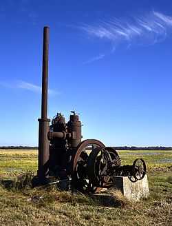
| 1 |
A.M. Bohnert Rice Plantation Pump #2 Engine |
|
02010-09-23-0000September 23, 2010
(#10000783) |
Southeast corner of U.S. Route 165 and Post Bayou Lane
34°02′35″N 91°22′24″W / 34.043165°N 91.373239°W / 34.043165; -91.373239 (A.M. Bohnert Rice Plantation Pump #2 Engine) |
Gillett vicinity |
|
| 2 |
Arkansas County Courthouse-Northern District |
Upload image |
01992-11-20-0000November 20, 1992
(#92001621) |
Southwestern corner of the junction of E. 3rd and S. College Sts.
34°29′59″N 91°33′06″W / 34.499722°N 91.551667°W / 34.499722; -91.551667 (Arkansas County Courthouse-Northern District) |
Stuttgart |
|
| 3 |
Arkansas County Courthouse-Southern District |
Upload image |
01992-11-20-0000November 20, 1992
(#92001620) |
Courthouse Sq.
34°17′42″N 91°20′06″W / 34.295°N 91.335°W / 34.295; -91.335 (Arkansas County Courthouse-Southern District) |
De Witt |
|
| 4 |
Arkansas Post National Memorial |
|
01966-10-15-0000October 15, 1966
(#66000198) |
8 miles (13 km) southeast of Gillett on Highways 1 and 169
34°01′15″N 91°20′54″W / 34.020833°N 91.348333°W / 34.020833; -91.348333 (Arkansas Post National Memorial) |
Gillett |
|
| 5 |
L.A. Black Rice Milling Association Inc. Office |
Upload image |
02013-01-29-0000January 29, 2013
(#12001229) |
508 S. Monroe St.
34°17′26″N 91°20′27″W / 34.290632°N 91.34072°W / 34.290632; -91.34072 (L.A. Black Rice Milling Association Inc. Office) |
DeWitt |
|
| 6 |
Crocketts Bluff Hunting Lodge |
Upload image |
02008-08-01-0000August 1, 2008
(#08000723) |
End of a dirt road north of the point at which Highway 153 turns south
34°26′51″N 91°13′15″W / 34.447519°N 91.220869°W / 34.447519; -91.220869 (Crocketts Bluff Hunting Lodge) |
Crocketts Bluff |
|
| 7 |
DeWitt Commercial Historic District |
Upload image |
02010-04-27-0000April 27, 2010
(#10000213) |
Roughly bounded by N. Washington, 2nd St., S. Adams and Gibson Ave.
34°17′41″N 91°20′06″W / 34.294778°N 91.33505°W / 34.294778; -91.33505 (DeWitt Commercial Historic District) |
De Witt |
|
| 8 |
DeWitt Post Office |
Upload image |
01998-08-14-0000August 14, 1998
(#98000915) |
221 W. Cross St.
34°17′42″N 91°20′14″W / 34.295°N 91.337222°W / 34.295; -91.337222 (DeWitt Post Office) |
De Witt |
|
| 9 |
First United Methodist Church |
Upload image |
01992-09-04-0000September 4, 1992
(#92001158) |
Junction of Jefferson and Cross Sts.
34°17′42″N 91°20′16″W / 34.295°N 91.337778°W / 34.295; -91.337778 (First United Methodist Church) |
De Witt |
|
| 10 |
Halliburton House |
Upload image |
01974-11-05-0000November 5, 1974
(#74000464) |
300 W. Halliburton St.
34°17′55″N 91°20′15″W / 34.298611°N 91.3375°W / 34.298611; -91.3375 (Halliburton House) |
De Witt |
|
| 11 |
Immanuel High School-AR0280 |
Upload image |
02007-01-24-0000January 24, 2007
(#06001282) |
68 Immanuel Rd.
34°24′06″N 91°19′19″W / 34.401667°N 91.321944°W / 34.401667; -91.321944 (Immanuel High School-AR0280) |
Almyra |
|
| 12 |
Maxwell Street Bridge |
Upload image |
02011-04-08-0000April 8, 2011
(#10001148) |
Maxwell St., east of Jefferson St.
34°17′51″N 91°20′15″W / 34.2975°N 91.3375°W / 34.2975; -91.3375 (Maxwell Street Bridge) |
De Witt |
|
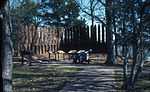
| 13 |
Menard-Hodges Mounds (3AR4) |
|
01985-10-31-0000October 31, 1985
(#85003542) |
Southern corner of the irregular Section 2303, Township 8 South, Range 2 West[6]
33°58′57″N 91°15′45″W / 33.982500°N 91.262500°W / 33.982500; -91.262500 (Menard-Hodges Mounds (3AR4)) |
Nady |
Now owned by the National Park Service and administered as part of the Arkansas Post National Memorial.
|
| 14 |
North Jackson Street Bridge |
Upload image |
02011-04-08-0000April 8, 2011
(#10001151) |
North Jackson St., over Holt Branch
34°17′51″N 91°20′29″W / 34.2975°N 91.341389°W / 34.2975; -91.341389 (North Jackson Street Bridge) |
De Witt |
|
| 15 |
North Washington Street Bridge |
Upload image |
02014-01-22-0000January 22, 2014
(#13001102) |
N. Washington St. over Holt Branch
34°18′02″N 91°20′00″W / 34.300679°N 91.333321°W / 34.300679; -91.333321 (North Washington Street Bridge) |
De Witt |
|
| 16 |
Old Arkansas 11, Kauffman Road Segment |
Upload image |
02006-09-20-0000September 20, 2006
(#06000834) |
Kauffman Rd.
34°22′59″N 91°32′26″W / 34.383056°N 91.540556°W / 34.383056; -91.540556 (Old Arkansas 11, Kauffman Road Segment) |
Stuttgart |
|
| 17 |
Old Gillett Jail |
Upload image |
02007-05-22-0000May 22, 2007
(#07000440) |
207 Main St.
34°07′09″N 91°22′45″W / 34.119167°N 91.379167°W / 34.119167; -91.379167 (Old Gillett Jail) |
Gillett |
|
| 18 |
Riceland Hotel |
|
01986-05-21-0000May 21, 1986
(#86001105) |
3rd and Main Sts.
34°30′00″N 91°33′10″W / 34.500116°N 91.552705°W / 34.500116; -91.552705 (Riceland Hotel) |
Stuttgart |
|
| 19 |
Roland Site |
Upload image |
01975-05-02-0000May 2, 1975
(#75000372) |
Address Restricted
|
Tichnor |
|
| 20 |
St. Charles Battle Monument |
Upload image |
01996-05-03-0000May 3, 1996
(#96000505) |
Junction of Arkansas St. and Broadway
34°22′26″N 91°08′08″W / 34.373889°N 91.135556°W / 34.373889; -91.135556 (St. Charles Battle Monument) |
St. Charles |
|
| 21 |
St. Charles Battle Site |
|
01974-12-02-0000December 2, 1974
(#74000465) |
Junction of Highway 1 and the White River
34°22′41″N 91°07′34″W / 34.378056°N 91.126111°W / 34.378056; -91.126111 (St. Charles Battle Site) |
St. Charles |
Site of the Civil War Battle of Saint Charles.
|
| 22 |
Standard Ice Company Building |
|
01979-07-02-0000July 2, 1979
(#79003433) |
517 S. Main St.
34°29′52″N 91°33′08″W / 34.497778°N 91.552222°W / 34.497778; -91.552222 (Standard Ice Company Building) |
Stuttgart |
|
| 23 |
Stuttgart Commercial Historic District |
Upload image |
02007-06-04-0000June 4, 2007
(#07000502) |
Roughly bounded by 1st St., College St., 6th St., and Maple St.
34°29′52″N 91°33′08″W / 34.497778°N 91.552222°W / 34.497778; -91.552222 (Stuttgart Commercial Historic District) |
Stuttgart |
|
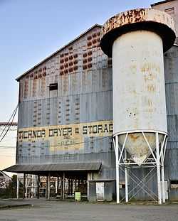
| 24 |
Tichnor Rice Dryer and Storage Building |
|
02006-09-22-0000September 22, 2006
(#06000911) |
1030 Highway 44
34°08′10″N 91°15′56″W / 34.13622°N 91.265522°W / 34.13622; -91.265522 (Tichnor Rice Dryer and Storage Building) |
Tichnor |
|
| 25 |
US Post Office-Stuttgart |
Upload image |
02004-01-14-0000January 14, 2004
(#03001380) |
302 S. Maple
34°29′59″N 91°33′14″W / 34.499722°N 91.553889°W / 34.499722; -91.553889 (US Post Office-Stuttgart) |
Stuttgart |
|

.jpg)
.jpg)