| [3] |
Name on the Register |
Image |
Date listed[4] |
Location |
City or town |
Description |
|---|
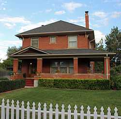
| 1 |
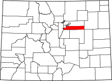
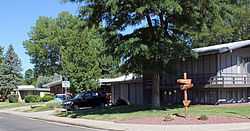
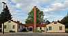
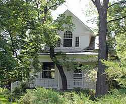
Arapahoe Acres |
|
01998-11-03-0000November 3, 1998
(#98001249) |
Roughly bounded by W. Bates and Dartmouth Aves. and S. Marion and Franklin Sts.
39°39′44″N 104°58′13″W / 39.662222°N 104.970278°W / 39.662222; -104.970278 (Arapahoe Acres) |
Englewood |
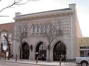
|
| 2 |
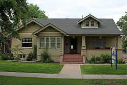
Arapaho Hills |
|
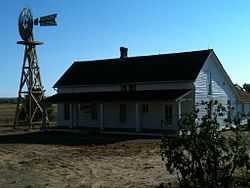
02012-08-28-0000August 28, 2012
(#12000550) |
Bounded by Arrowhead, W. Berry, & S. Manitou Rds., S. Lowell Blvd.
39°37′07″N 105°02′12″W / 39.618747°N 105.036691°W / 39.618747; -105.036691 (Arapaho Hills) |
Littleton |
part of the Residential Subdivisions of Metropolitan Denver, 1940-1965 Multiple Property Submission (MPS)
|
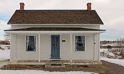
| 3 |
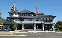
David W. Brown House |
|
01980-04-10-0000April 10, 1980
(#80000875) |
2303 E. Dartmouth Ave.
39°39′38″N 104°57′38″W / 39.660556°N 104.960556°W / 39.660556; -104.960556 (David W. Brown House) |
Englewood |
|
| 4 |
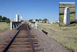
Comanche Crossing of the Kansas Pacific Railroad |
|
01970-08-10-0000August 10, 1970
(#70000152) |
On Union Pacific Railroad tracks east of the Strasburg depot
39°44′15″N 104°18′29″W / 39.7375°N 104.308056°W / 39.7375; -104.308056 (Comanche Crossing of the Kansas Pacific Railroad) |
Strasburg |
|
| 5 |
Commandant of Cadets Building, US Air Force Academy |
|
02007-04-24-0000April 24, 2007
(#07000340) |
1016 Boston St.
39°43′48″N 104°52′41″W / 39.73°N 104.878056°W / 39.73; -104.878056 (Commandant of Cadets Building, US Air Force Academy) |
Aurora |
|
| 6 |
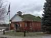
Curtis School |
|
01992-06-25-0000June 25, 1992
(#92000808) |
2349 E. Orchard Rd.
39°36′37″N 104°57′37″W / 39.610278°N 104.960278°W / 39.610278; -104.960278 (Curtis School) |
Greenwood Village |
part of the Rural School Buildings in Colorado MPS
|
| 7 |
DeLaney Barn |
|
01989-02-09-0000February 9, 1989
(#89000010) |
200 S. Chambers Rd.
39°42′48″N 104°48′27″W / 39.713333°N 104.8075°W / 39.713333; -104.8075 (DeLaney Barn) |
Aurora |
|
| 8 |
Englewood Post Office |
|
02011-07-20-0000July 20, 2011
(#11000465) |
3332 S. Broadway
39°39′22″N 104°59′14″W / 39.656111°N 104.987222°W / 39.656111; -104.987222 (Englewood Post Office) |
Englewood |
|
| 9 |
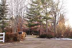
Foster-Buell Estate |
Upload image |
01998-04-01-0000April 1, 1998
(#98000294) |
2700 E. Hampden Ave.
39°38′50″N 104°57′01″W / 39.647222°N 104.950278°W / 39.647222; -104.950278 (Foster-Buell Estate) |
Cherry Hills Village |
|
| 10 |
Geneva Home |
|
01999-01-21-0000January 21, 1999
(#98001635) |
2305 W. Berry Ave.
39°37′04″N 105°00′53″W / 39.617778°N 105.014722°W / 39.617778; -105.014722 (Geneva Home) |
Littleton |
|
| 11 |
Gully Homestead |
|
01986-01-09-0000January 9, 1986
(#86000022) |
200 S. Chambers Rd.
39°42′44″N 104°48′32″W / 39.712222°N 104.808889°W / 39.712222; -104.808889 (Gully Homestead) |
Aurora |
|
| 12 |
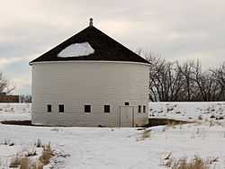
Hopkins Farm |
|
02007-04-24-0000April 24, 2007
(#07000341) |
4400 E. Quincy Ave.
39°38′15″N 104°56′17″W / 39.637447°N 104.93805°W / 39.637447; -104.93805 (Hopkins Farm) |
Cherry Hills Village |
|
| 13 |
Knight-Wood House |
|
02004-10-06-0000October 6, 2004
(#04001111) |
1860 W. Littleton Boulevard
39°36′47″N 105°00′34″W / 39.613056°N 105.009444°W / 39.613056; -105.009444 (Knight-Wood House) |
Littleton |
|
| 14 |
Little Estate |
|
01998-05-29-0000May 29, 1998
(#98000610) |
1 Littleridge Ln.
39°38′58″N 104°58′10″W / 39.649444°N 104.969444°W / 39.649444; -104.969444 (Little Estate) |
Cherry Hills Village |
|
| 15 |
Littleton Main Street |
|
01998-04-08-0000April 8, 1998
(#98000291) |
Roughly along W. Main St. from S. Curtice St. to S. Sycamore St.
39°36′50″N 105°00′58″W / 39.613889°N 105.016111°W / 39.613889; -105.016111 (Littleton Main Street) |
Littleton |
|
| 16 |
Littleton Town Hall |
|
01980-09-04-0000September 4, 1980
(#80000876) |
2450 W. Main St.
39°36′48″N 105°00′59″W / 39.613333°N 105.016389°W / 39.613333; -105.016389 (Littleton Town Hall) |
Littleton |
|
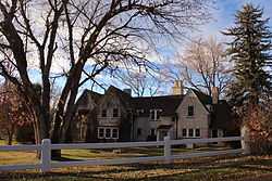
| 17 |
Maitland Estate |
|
01998-09-03-0000September 3, 1998
(#98001130) |
9 Sunset Dr.
39°38′52″N 104°57′35″W / 39.647778°N 104.959722°W / 39.647778; -104.959722 (Maitland Estate) |
Cherry Hills Village |
|
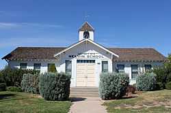
| 18 |
Melvin School |
|
01984-01-05-0000January 5, 1984
(#84000790) |
4950 S. Laredo St.
39°37′34″N 104°48′09″W / 39.626111°N 104.8025°W / 39.626111; -104.8025 (Melvin School) |
Aurora |
part of the Rural School Buildings in Colorado MPS
|
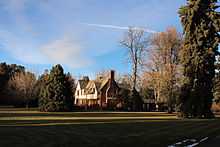
| 19 |
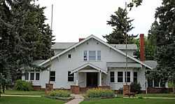
Owen Estate |
|
01999-09-17-0000September 17, 1999
(#99001143) |
3901 S. Gilpin St.
39°38′50″N 104°58′03″W / 39.647222°N 104.9675°W / 39.647222; -104.9675 (Owen Estate) |
Cherry Hills Village |
|
| 20 |
Seventeen Mile House |
|
01983-10-06-0000October 6, 1983
(#83003501) |
8181 S. Parker Rd.
39°34′05″N 104°47′14″W / 39.568056°N 104.787222°W / 39.568056; -104.787222 (Seventeen Mile House) |
Centennial |
|
| 21 |
William Smith House |
|
01985-09-26-0000September 26, 1985
(#85002565) |
412 Oswego Ct.
39°43′17″N 104°50′58″W / 39.721389°N 104.849444°W / 39.721389; -104.849444 (William Smith House) |
Aurora |
|