National Register of Historic Places listings in Alfalfa County, Oklahoma

Location of Alfalfa County in Oklahoma
This is a list of the National Register of Historic Places listings in Alfalfa County, Oklahoma.
This is intended to be a complete list of the properties on the National Register of Historic Places in Alfalfa County, Oklahoma, United States. The locations of National Register properties for which the latitude and longitude coordinates are included below, may be seen in a Google map.[1]
There are 12 properties listed on the National Register in the county.
- This National Park Service list is complete through NPS recent listings posted May 1, 2015.[2]
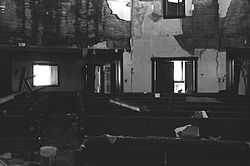
Current listings
| [3] |
Name on the Register[4] |
Image |
Date listed[5] |
Location |
City or town |
Description |
|---|
| 1 |
Alfalfa County Courthouse |
|
01984-08-23-0000August 23, 1984
(#84002937) |
Grand Ave.
36°45′18″N 98°21′22″W / 36.755°N 98.356111°W / 36.755; -98.356111 (Alfalfa County Courthouse) |
Cherokee |
|
| 2 |
Aline IOOF Lodge No. 263 |
Upload image |
01984-03-08-0000March 8, 1984
(#84002941) |
Off Main and Broadway
36°30′35″N 98°26′58″W / 36.509722°N 98.449444°W / 36.509722; -98.449444 (Aline IOOF Lodge No. 263) |
Aline |
|
| 3 |
Carmen IOOF Home |
Upload image |
01984-03-08-0000March 8, 1984
(#84002944) |
North of Carmen
36°35′43″N 98°27′43″W / 36.595278°N 98.461944°W / 36.595278; -98.461944 (Carmen IOOF Home) |
Carmen |
|
| 4 |
Carmen IOOF Lodge No. 84 |
Upload image |
01984-03-08-0000March 8, 1984
(#84002948) |
Main and 4th St.
36°34′45″N 98°27′30″W / 36.579167°N 98.458333°W / 36.579167; -98.458333 (Carmen IOOF Lodge No. 84) |
Carmen |
|
| 5 |
Cherokee Armory |
Upload image |
01988-09-08-0000September 8, 1988
(#88001371) |
2nd and Kansas Sts.
36°45′23″N 98°21′21″W / 36.756389°N 98.355833°W / 36.756389; -98.355833 (Cherokee Armory) |
Cherokee |
|
| 6 |
Cherokee Friends Church |
|
02004-12-06-0000December 6, 2004
(#04001337) |
120 S. Pennsylvania
36°45′25″N 98°21′14″W / 36.756944°N 98.353889°W / 36.756944; -98.353889 (Cherokee Friends Church) |
Cherokee |
|
| 7 |
Cherokee IOOF Lodge No. 219 |
Upload image |
01984-03-08-0000March 8, 1984
(#84002953) |
Grand Ave. and 2nd St.
36°45′23″N 98°21′25″W / 36.756389°N 98.356944°W / 36.756389; -98.356944 (Cherokee IOOF Lodge No. 219) |
Cherokee |
|
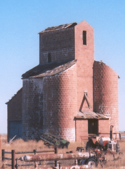
| 8 |
Farmers' Exchange Elevator |
Upload image |
01983-10-07-0000October 7, 1983
(#83004152) |
State Highway 45
36°31′57″N 98°09′15″W / 36.5325°N 98.154167°W / 36.5325; -98.154167 (Farmers' Exchange Elevator) |
Goltry |
|
| 9 |
Farmers' Federation Elevator |
Upload image |
01983-10-07-0000October 7, 1983
(#83004153) |
Ohio Ave. and 4th St.
36°45′23″N 98°21′34″W / 36.756389°N 98.359444°W / 36.756389; -98.359444 (Farmers' Federation Elevator) |
Cherokee |
|
| 10 |
Hotel Cherokee |
Upload image |
01998-03-05-0000March 5, 1998
(#98000200) |
117 W. Main
36°45′29″N 98°21′28″W / 36.758056°N 98.357778°W / 36.758056; -98.357778 (Hotel Cherokee) |
Cherokee |
|
| 11 |
Ingersoll Tile Elevator |
|
01983-10-07-0000October 7, 1983
(#83004156) |
Off U.S. Route 64
36°47′49″N 98°23′20″W / 36.796944°N 98.388889°W / 36.796944; -98.388889 (Ingersoll Tile Elevator) |
Ingersoll |
|
| 12 |
Sod House |
Upload image |
01970-09-29-0000September 29, 1970
(#70000526) |
About 4 miles north of Cleo Springs
36°28′17″N 98°25′23″W / 36.471389°N 98.423056°W / 36.471389; -98.423056 (Sod House) |
Cleo Springs |
|
See also
References
- ↑ The latitude and longitude information provided in this table was derived originally from the National Register Information System, which has been found to be fairly accurate for about 99% of listings. For about 1% of NRIS original coordinates, experience has shown that one or both coordinates are typos or otherwise extremely far off; some corrections may have been made. A more subtle problem causes many locations to be off by up to 150 yards, depending on location in the country: most NRIS coordinates were derived from tracing out latitude and longitudes off of USGS topographical quadrant maps created under the North American Datum of 1927, which differs from the current, highly accurate WGS84 GPS system used by most on-line maps. Chicago is about right, but NRIS longitudes in Washington are higher by about 4.5 seconds, and are lower by about 2.0 seconds in Maine. Latitudes differ by about 1.0 second in Florida. Some locations in this table may have been corrected to current GPS standards.
- ↑ "National Register of Historic Places: Weekly List Actions". National Park Service, United States Department of the Interior. Retrieved on May 1, 2015.
- ↑ Numbers represent an ordering by significant words. Various colorings, defined here, differentiate National Historic Landmarks and historic districts from other NRHP buildings, structures, sites or objects.
- ↑ "National Register Information System". National Register of Historic Places. National Park Service. 2009-03-13.
- ↑ The eight-digit number below each date is the number assigned to each location in the National Register Information System database, which can be viewed by clicking the number.
|
|---|
| | Topics | |
|---|
| | Lists by states | |
|---|
| | Lists by insular areas | |
|---|
| | Lists by associated states | |
|---|
| | Other areas | |
|---|
|
-
 Category Category
-
 Portal Portal
-
 WikiProject WikiProject
|
|