National Register of Historic Places listings in Alamosa County, Colorado

Location of Alamosa County in Colorado
This is a list of the National Register of Historic Places listings in Alamosa County, Colorado. It is intended to be a complete list of the properties and districts on the National Register of Historic Places in Alamosa County, Colorado, United States. The locations of National Register properties and districts for which the latitude and longitude coordinates are included below, may be seen in a Google map.[1]
There are 15 properties and districts listed on the National Register in the county.
- This National Park Service list is complete through NPS recent listings posted May 1, 2015.[2]
| Adams - Alamosa - Arapahoe - Archuleta - Baca - Bent - Boulder - Broomfield - Chaffee - Cheyenne - Clear Creek - Conejos - Costilla - Crowley - Custer - Delta - Denver - Dolores - Douglas - Eagle - El Paso - Elbert - Fremont - Garfield - Gilpin - Grand - Gunnison - Hinsdale - Huerfano - Jackson - Jefferson - Kiowa - Kit Carson - La Plata - Lake - Larimer - Las Animas - Lincoln - Logan - Mesa - Mineral - Moffat - Montezuma - Montrose - Morgan - Otero - Ouray - Park - Phillips - Pitkin - Prowers - Pueblo - Rio Blanco - Rio Grande - Routt - Saguache - San Juan - San Miguel - Sedgwick - Summit - Teller - Washington - Weld - Yuma |
Listings county-wide
| [3] | Name on the Register[4] | Image | Date listed[5] | Location | City or town | Description |
|---|---|---|---|---|---|---|
| 1 | Alamosa County Courthouse | |
(#95001149) |
702 4th St. 37°28′08″N 105°52′02″W / 37.468889°N 105.867222°W |
Alamosa | |
| 2 | Alamosa Post Office | |
(#09000544) |
703 4th St. 37°28′09″N 105°52′02″W / 37.4693°N 105.867153°W |
Alamosa | |
| 3 | American National Bank Building | 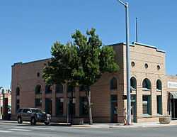 |
(#99000446) |
500 State Ave. 37°28′05″N 105°51′53″W / 37.468056°N 105.864722°W |
Alamosa | |
| 4 | Denver and Rio Grande Railroad Depot | |
(#93000034) |
610 State St. 37°28′00″N 105°51′53″W / 37.466667°N 105.864722°W |
Alamosa | |
| 5 | Denver and Rio Grande Railroad Locomotive No.169 | 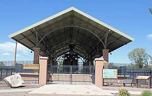 |
(#01000230) |
Along Chamber Dr. within Cole Park 37°28′10″N 105°51′45″W / 37.469444°N 105.8625°W |
Alamosa | |
| 6 | First Baptist Church | .JPG) |
(#05000425) |
408 State Ave. 37°28′08″N 105°51′53″W / 37.468889°N 105.864722°W |
Alamosa | |
| 7 | Howard Store | 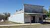 |
(#05001597) |
8681 Main St. 37°44′47″N 105°52′37″W / 37.746389°N 105.876944°W |
Hooper | |
| 8 | Husung Hardware | 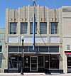 |
(#00000003) |
625 Main St. 37°28′06″N 105°51′57″W / 37.4683°N 105.8658°W |
Alamosa | |
| 9 | Medano Ranch Headquarters | 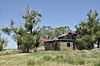 |
(#03001543) |
2.6 miles north of County Road 6N, Medano-Zapata Ranch 37°42′52″N 105°40′55″W / 37.7144°N 105.6819°W |
Mosca | A Nature Conservancy-owned historic ranch property located within Great Sand Dunes National Park; access is limited. |
| 10 | Mt. Pleasant School | 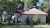 |
(#06000327) |
Junction of County Roads 3, S. and 103, S. 37°31′52″N 105°59′01″W / 37.531111°N 105.983611°W |
Alamosa | |
| 11 | Sacred Heart Catholic Church | .JPG) |
(#98000855) |
727 4th St. 37°28′11″N 105°52′04″W / 37.4697°N 105.8678°W |
Alamosa | |
| 12 | St. Thomas Episcopal Church | |
(#03000285) |
607 4th St. 37°28′10″N 105°51′57″W / 37.469444°N 105.865833°W |
Alamosa | |
| 13 | Superintendent's Residence, Great Sand Dunes National Monument | 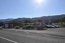 |
(#89001761) |
State Highway 150 southwest of Mosca 37°43′30″N 105°31′05″W / 37.725°N 105.5181°W |
Mosca | At the entrance gate to the Great Sand Dunes National Park. |
| 14 | Trujillo Homestead | 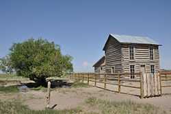 |
(#03001544) |
Medano-Zapata Ranch 37°44′00″N 105°44′09″W / 37.7333°N 105.7358°W |
Mosca | On Nature Conservancy land in or near the Great Sand Dunes National Park; access is limited. |
| 15 | Zapata Ranch Headquarters | 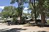 |
(#93000199) |
5303 State Highway 150 37°39′10″N 105°35′33″W / 37.6528°N 105.5925°W |
Mosca | A Nature Conservancy-owned historic ranch property located near the Great Sand Dunes National Park. |
See also
| Wikimedia Commons has media related to National Register of Historic Places in Alamosa County, Colorado. |
- List of National Historic Landmarks in Colorado
- National Register of Historic Places listings in Colorado
References
- ↑ The latitude and longitude information provided in this table was derived originally from the National Register Information System, which has been found to be fairly accurate for about 99% of listings. For about 1% of NRIS original coordinates, experience has shown that one or both coordinates are typos or otherwise extremely far off; some corrections may have been made. A more subtle problem causes many locations to be off by up to 150 yards, depending on location in the country: most NRIS coordinates were derived from tracing out latitude and longitudes off of USGS topographical quadrant maps created under the North American Datum of 1927, which differs from the current, highly accurate WGS84 GPS system used by most on-line maps. Chicago is about right, but NRIS longitudes in Washington are higher by about 4.5 seconds, and are lower by about 2.0 seconds in Maine. Latitudes differ by about 1.0 second in Florida. Some locations in this table may have been corrected to current GPS standards.
- ↑ "National Register of Historic Places: Weekly List Actions". National Park Service, United States Department of the Interior. Retrieved on May 1, 2015.
- ↑ Numbers represent an ordering by significant words. Various colorings, defined here, differentiate National Historic Landmarks and historic districts from other NRHP buildings, structures, sites or objects.
- ↑ "National Register Information System". National Register of Historic Places. National Park Service. 2008-04-24.
- ↑ The eight-digit number below each date is the number assigned to each location in the National Register Information System database, which can be viewed by clicking the number.
| ||||||||||||||||||||||||||
| |||||||||||||||||||||||||