National Register of Historic Places listings in Acadia National Park
This is a list of the National Register of Historic Places listings in Acadia National Park.
This is intended to be a complete list of the properties and districts on the National Register of Historic Places in Acadia National Park, Maine, United States. The locations of National Register properties and districts for which the latitude and longitude coordinates are included below, may be seen in a Google map.[1]
There are ten properties and districts listed on the National Register in the park.
- This National Park Service list is complete through NPS recent listings posted May 1, 2015.[2]
Current listings
| [3] |
Name on the Register |
Image |
Date listed[4] |
Location |
City or town |
Description |
|---|
| 1 |
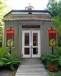
Robert Abbe Museum of Stone Antiquities |
|
01983-01-19-0000January 19, 1983
(#83000451) |
South of Bar Harbor off State Route 3
44°21′40″N 68°12′30″W / 44.361111°N 68.208333°W / 44.361111; -68.208333 (Robert Abbe Museum of Stone Antiquities) |
Bar Harbor |
|
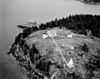
| 2 |
Baker Island Light Station |
|
01988-03-14-0000March 14, 1988
(#88000046) |
Baker Island in Acadia National Park
44°14′28″N 68°11′56″W / 44.241111°N 68.198889°W / 44.241111; -68.198889 (Baker Island Light Station) |
Islesford |
First light station serving Mount Desert Island—established in 1828—with a surviving 1855 light tower and keeper's house.[5]
|
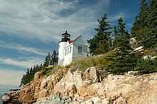
| 3 |
Bass Harbor Head Light Station |
|
01988-01-21-0000January 21, 1988
(#87002273) |
Bass Harbor Head
44°13′19″N 68°20′16″W / 44.221944°N 68.337778°W / 44.221944; -68.337778 (Bass Harbor Head Light Station) |
Bass Harbor |
|
| 4 |
Bear Island Light Station |
|
01988-03-14-0000March 14, 1988
(#88000043) |
Bear Island, Acadia National Park
44°17′00″N 68°16′14″W / 44.283333°N 68.270556°W / 44.283333; -68.270556 (Bear Island Light Station) |
Northeast Harbor |
Light station established in 1839 to serve Northeast Harbor, with a surviving 1889 light tower and keeper's house and 1905 outbuildings.[6]
|
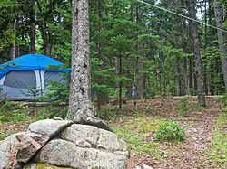
| 5 |
Blackwoods Campground |
|
02007-06-29-0000June 29, 2007
(#07000612) |
State Route 233, Eagle Lake Rd.
44°18′38″N 68°12′15″W / 44.310676°N 68.204094°W / 44.310676; -68.204094 (Blackwoods Campground) |
Bar Harbor |
CCC-built campground on the east side of the park.
|
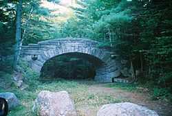
| 6 |
Carriage Paths, Bridges and Gatehouses |
|
01979-11-14-0000November 14, 1979
(#79000131) |
Acadia National Park and vicinity
44°20′32″N 68°15′30″W / 44.342222°N 68.258333°W / 44.342222; -68.258333 (Carriage Paths, Bridges and Gatehouses) |
Acadia National Park |
Network of scenic carriage roads with 13 bridges and two gatehouse complexes, established 1919–1931 by John D. Rockefeller, Jr. for automobile-free recreation by high-society vacationers. Now open to non-motorized use by the public.[7]
|
| 7 |
Fernald Point Prehistoric Site |
Upload image |
01978-07-21-0000July 21, 1978
(#78000164) |
Fernald Point[8]
44°17′53″N 68°18′35″W / 44.2980°N 68.3098°W / 44.2980; -68.3098 (Fernald Point Prehistoric Site) |
Southwest Harbor |
|
| 8 |
Islesford Historical Museum and Blue Duck Ships Store |
Upload image |
01980-09-30-0000September 30, 1980
(#80000224) |
Little Cranberry Island
44°15′42″N 68°14′25″W / 44.261667°N 68.240278°W / 44.261667; -68.240278 (Islesford Historical Museum and Blue Duck Ships Store) |
Islesford |
|
| 9 |
Schoodic Peninsula Historic District |
Upload image |
02007-06-29-0000June 29, 2007
(#07000614) |
1.5 miles south of State Route 186
44°22′30″N 68°03′50″W / 44.374975°N 68.063829°W / 44.374975; -68.063829 (Schoodic Peninsula Historic District) |
Winter Harbor |
|
| 10 |
Seawall Campground |
Upload image |
02007-06-29-0000June 29, 2007
(#07000613) |
State Route 233, Eagle Lake Rd.
44°14′26″N 68°18′16″W / 44.240495°N 68.304327°W / 44.240495; -68.304327 (Seawall Campground) |
Bar Harbor |
|
See also
References
- ↑ The latitude and longitude information provided in this table was derived originally from the National Register Information System, which has been found to be fairly accurate for about 99% of listings. For about 1% of NRIS original coordinates, experience has shown that one or both coordinates are typos or otherwise extremely far off; some corrections may have been made. A more subtle problem causes many locations to be off by up to 150 yards, depending on location in the country: most NRIS coordinates were derived from tracing out latitude and longitudes off of USGS topographical quadrant maps created under the North American Datum of 1927, which differs from the current, highly accurate WGS84 GPS system used by most on-line maps. Chicago is about right, but NRIS longitudes in Washington are higher by about 4.5 seconds, and are lower by about 2.0 seconds in Maine. Latitudes differ by about 1.0 second in Florida. Some locations in this table may have been corrected to current GPS standards.
- ↑ "National Register of Historic Places: Weekly List Actions". National Park Service, United States Department of the Interior. Retrieved on May 1, 2015.
- ↑ Numbers represent an ordering by significant words. Various colorings, defined here, differentiate National Historic Landmarks and historic districts from other NRHP buildings, structures, sites or objects.
- ↑ The eight-digit number below each date is the number assigned to each location in the National Register Information System database, which can be viewed by clicking the number.
- ↑ Mohney, Kirk F. (October 1987). "National Register of Historic Places Registration Form: Baker Island Light Station" (PDF). National Park Service. Retrieved 2013-03-23.
- ↑ Mohney, Kirk F. (October 1987). "National Register of Historic Places Registration Form: Bear Island Light Station" (PDF). National Park Service. Retrieved 2013-03-23.
- ↑ Krog, Bronwyn (1979-03-07). "National Register of Historic Places Registration Form: The Carriage Paths, Bridges and Gatehouses, Acadia National Park" (PDF). National Park Service. Retrieved 2013-03-30.
- ↑ "An Island In Time" (PDF). The Abbe Museum. Retrieved 2015-02-10.
|
|---|
| | Historic districts | |
|---|
| | Other properties | |
|---|
| |
|
|
|---|
| | Topics | |
|---|
| | Lists by states | |
|---|
| | Lists by insular areas | |
|---|
| | Lists by associated states | |
|---|
| | Other areas | |
|---|
|
-
 Category Category
-
 Portal Portal
-
 WikiProject WikiProject
|
|
.jpg)