National Bison Range
| National Bison Range | |
|---|---|
|
IUCN category IV (habitat/species management area) | |
 | |
 | |
| Location | Lake / Sanders counties, Montana, USA |
| Nearest city | Missoula, MT |
| Coordinates | 47°19′30″N 114°13′33″W / 47.32500°N 114.22583°WCoordinates: 47°19′30″N 114°13′33″W / 47.32500°N 114.22583°W[1] |
| Area | 18,800 acres (7,600 ha) |
| Established | 1908 |
| Visitors | est. 250,000 (in 2004) |
| Governing body | U.S. Fish and Wildlife Service |
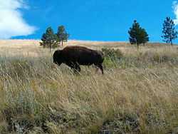
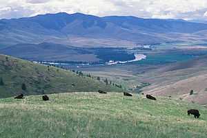
The National Bison Range (NBR) is a National Wildlife Refuge located in western Montana established in 1908 to provide a sanctuary for the American bison.[2][3] The NBR is one of the oldest National Wildlife Refuges in the United States. The size of the bison herd at the NBR is relatively small, numbering between 350 and 500 individuals. The initial herd of American bison was provided by organizations such as the American Bison Society, and today the refuge serves as the central point for bison research in the United States.
The NBR consists of approximately 18,800 acres (7,600 ha) and is managed by the U.S. Fish and Wildlife Service. Other nearby National Wildlife Refuges are managed as parts of the National Bison Range Complex and include the Lost Trail, Ninepipe, Pablo and the Swan River National Wildlife Refuges. Also affiliated is the Northwest Montana Wetland Management District.
The NBR has a visitor center, and two scenic roads that allow vehicular access to prime viewing areas. The refuge is approximately one hour north of Missoula, Montana with signs off of U.S. Highway 93 directing visitors to the entrance at Moiese, Montana, and the refuge headquarters.
Geology

The Refuge is essentially a small, low-rolling mountain connected to the Mission Mountain Range by a gradually descending spur. Range elevation varies from 2,585 feet at headquarters to 4,885 feet at High Point on Red Sleep Mountain, the highest point on the Range. Much of the National Bison Range was once under prehistoric Glacial Lake Missoula, which was formed by a glacial ice dam on the Clark Fork River about 13,000 to 18,000 years ago. The lake attained a maximum elevation of 4,200 feet, so the upper part of the Refuge was above water. Old beach lines are still evident on north-facing slopes. Topsoil on the Range is generally shallow and mostly underlain with rock which is exposed in many areas, forming ledges and talus slopes. Soils over the major portion of the Range were developed from materials weathered from strongly folded pre-Cambrian quartzite and argillite bedrock.[4]
Biology and Ecology
Fauna

Once believed to number in the tens of millions, bison once were found in all the current U.S. states, except Hawaii, and also throughout Canada.
Bison were nearly extinct by 1890, having been part of a Federal government sponsored program of eradication during the Indian Wars, thereby removing a vital food source from the Plains Indians diet, and ensuring easier relocation onto Indian reservations.
Bison were also considered to be a less desirable food source than domesticated cattle because of their wild nature. They were also viewed as competition for prime grazing lands that could be used by cattle.
By the beginning of the 20th century efforts were being made to preserve the remaining bison and protect areas in which they could reconstitute. Approximately 250,000 bison can be found on federal and state lands, and in privately owned herds.
Bison have an average of 60% of the fat content per pound of beef and more protein. Most of the private herds are used as a food source. Bison meat is gaining in popularity and often found in grocery stores and restaurants.
In addition to the 350 to 500 American bison (buffalo) on the National Bison Range, many other mammal species may be seen on the refuge, including elk (wapiti), mule deer, bighorn sheep, white-tailed deer, pronghorn, mountain cottontail, Columbian ground squirrel, muskrat, yellow-pine chipmunk, American badger, American black bear, cougar (mountain lion), and coyote.[5]
Over two hundred bird species have been seen on the refuge.[6]
-
American Bison
-

Western Meadowlark (Sturnella neglecta)
-

Bison at the National Bison Range
-
Ruffed grouse (Bonasa Umbellus)
-
A pronghorn (Antilocapra americana)
-
Elk (Cervus canadensis) in a creek
Flora
The National Bison Range contains many plant species, including the bitterroot, ponderosa pine, and buffalo grass.[7]
References
| Wikimedia Commons has media related to National Bison Range. |
- ↑ "National Bison Range". Geographic Names Information System. United States Geological Survey. Retrieved February 22, 2014.
- ↑ Ravalli, MT (Map). Topoquest (USGS Quads). Retrieved February 22, 2014.
- ↑ "Annual Report of Lands Under Control of the U.S. Fish and Wildlife Service" (PDF). U.S. Fish and Wildlife Service. September 30, 2010. p. 23. Retrieved February 22, 2014.
- ↑ About the Refuge, March 12, 2013, viewed November 6, 2013, U.S. Fish and Wildlife Service, http://www.fws.gov/refuge/National_Bison_Range/about.html
- ↑ Mammals - National Bison Range - U.S. Fish and Wildlife Service, 6 Feb. 2013. Web. 06 Nov. 2013. http://www.fws.gov/refuge/national_bison_range/wildlife_and_habitat/Animals.html
- ↑ U.S. Fish and Wildlife Service. No date. Birds of National Bison Range. U.S. Fish and Wildlife Service. Unpaginated. Jamestown, ND: Northern Prairie Wildlife Research Center Online. http://www.fws.gov/uploadedFiles/NBR%20bird%20list.usgs.pdf
- ↑ Plants of the National Bison Range, September 1985, viewed November 6, 2013, U.S. Fish and Wildlife Service, http://www.fws.gov/uploadedFiles/NBR%20plant%20list.pdf
| ||||||||||||||||||||||||||||||||||||||||||||||||||||||||||


