Nataf
| Nataf | |
|---|---|
 Nataf | |
| Coordinates: 31°49′56.28″N 35°4′4.44″E / 31.8323000°N 35.0679000°ECoordinates: 31°49′56.28″N 35°4′4.44″E / 31.8323000°N 35.0679000°E | |
| Council | Mateh Yehuda |
| Region | Jerusalem corridor |
| Founded | 1982 |
| Website | natafnik.com |
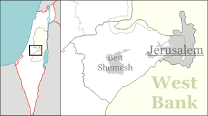
Nataf (Hebrew: נָטָף, eng. Stacte (a spice)) is a communal settlement in the Judean Mountains, 12 miles west of Jerusalem, Israel. Its biblical name is derived from "one of the spices used in the Temple".[1](Exodus 30:34) It is under the jurisdiction of Mateh Yehuda Regional Council. In 2006, Nataf had a population of 387.[2]
Geography
Nataf is situated on a ridge bounded by Kefira Valley to the north and Hamisha Valley to the south; the elevation is around 500m above MSL. It lies at the end of a 3-mile road that passes through Abu Ghosh.
History

Nataf was founded in 1982 on land belonging to the depopulated Palestinian village of Bayt Thul,[3] less than 1 km south of the village site of Nitaf.[4] It overlooks Nataf Valley, a popular hiking destination. Nataf spring is watered all year round and has a number of small freshwater pools. The name Nataf is of biblical origins and referred to the incense Stacte. Only 20% of the residents are Modern Orthodox; 80% of the residents are secular. The village has a unique unaffiliated synagogue with three sections for prayer: a men's section, a women's section and a mixed section.
Notable residents
- Avram Burg
- Bradley Burston
- Ehud Shapiro
References
| Wikimedia Commons has media related to Nataf. |
- ↑ Carta's Official Guide to Israel and Complete Gazetteer to all Sites in the Holy Land. (3rd edition 1993) Jerusalem, Carta, p.358, ISBN 965-220-186-3 (English)
Bitan, Hanna: 1948-1998: Fifty Years of 'Hityashvut': Atlas of Names of Settlements in Israel, Jerusalem 1999, Carta, p.47, ISBN 965-220-423-4 (Hebrew) - ↑ Terra Incognita: From Nataf to J'lem
- ↑ Khalidi, 1992, p. 290
- ↑ Khalidi, 1992, p. 307
Bibliography
- Khalidi, Walid (1992). All That Remains: The Palestinian Villages Occupied and Depopulated by Israel in 1948. Washington D.C.: Institute for Palestine Studies. ISBN 0-88728-224-5.