Napa, California
| City of Napa | |
|---|---|
| City, county seat | |
|
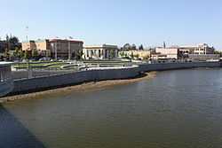
View of the Napa River flood wall, including part of downtown. | |
 Location in Napa County and the state of California | |
| Coordinates: 38°18′17″N 122°17′56″W / 38.30472°N 122.29889°WCoordinates: 38°18′17″N 122°17′56″W / 38.30472°N 122.29889°W[1] | |
| Country | United States |
| State | California |
| County | Napa |
| Incorporated | March 23, 1872[2] |
| Government | |
| • Mayor | Jill Techel[3] |
| Area[4] | |
| • City | 18.147 sq mi (47.000 km2) |
| • Land | 17.839 sq mi (46.203 km2) |
| • Water | 0.308 sq mi (0.797 km2) 1.69% |
| Elevation[5] | 20 ft (6 m) |
| Population (2010)[6] | |
| • City | 76,915 |
| • Density | 4,200/sq mi (1,600/km2) |
| • Metro | 136,484 |
| Time zone | Pacific (PST) (UTC-8) |
| • Summer (DST) | PDT (UTC-7) |
| ZIP codes[7] | 94558, 94559, 94581 |
| Area code | 707 |
| FIPS code | 06-50258 |
| GNIS feature IDs | 277561, 2411209 |
| Website |
www |
The city of Napa is the county seat of Napa County, California. It is the principal city of the Napa county Metropolitan Statistical Area, which encompasses Napa county. As of the 2010 census, the city had a total population of 76,915. Napa was incorporated as a city in 1872.
Geography and environment
According to the United States Census Bureau, the city has a total area of 18.1 square miles (47 km2). 17.8 square miles (46 km2) of it is land and 0.3 square miles (0.78 km2) of it (1.69%) is water. The Napa River traverses the city on its journey to the San Pablo Bay. The city has conducted a variety of waterfront development along the banks of the river including certain fill operations governed by the United States Army Corps of Engineers regulations.[8] The Napa River Flood Project has been in progress since the late 1990s with the goal of mitigating the risk of flooding along a 6-mile (9.7 km) stretch of the River and 1-mile (1.6 km) of Napa Creek.
Climate
| Climate data for Napa, California | |||||||||||||
|---|---|---|---|---|---|---|---|---|---|---|---|---|---|
| Month | Jan | Feb | Mar | Apr | May | Jun | Jul | Aug | Sep | Oct | Nov | Dec | Year |
| Record high °F (°C) | 85 (29) |
86 (30) |
92 (33) |
95 (35) |
104 (40) |
113 (45) |
112 (44) |
110 (43) |
110 (43) |
106 (41) |
90 (32) |
81 (27) |
113 (45) |
| Average high °F (°C) | 57.3 (14.1) |
62.2 (16.8) |
66.6 (19.2) |
71.2 (21.8) |
76.2 (24.6) |
81.1 (27.3) |
82.9 (28.3) |
83.0 (28.3) |
82.9 (28.3) |
76.7 (24.8) |
65.1 (18.4) |
57.1 (13.9) |
71.9 (22.2) |
| Average low °F (°C) | 39.4 (4.1) |
41.9 (5.5) |
43.5 (6.4) |
45.2 (7.3) |
49.6 (9.8) |
53.4 (11.9) |
55.1 (12.8) |
55.0 (12.8) |
53.2 (11.8) |
49.2 (9.6) |
43.7 (6.5) |
39.6 (4.2) |
47.4 (8.6) |
| Record low °F (°C) | 19 (−7) |
23 (−5) |
23 (−5) |
27 (−3) |
30 (−1) |
34 (1) |
38 (3) |
32 (0) |
36 (2) |
28 (−2) |
25 (−4) |
14 (−10) |
14 (−10) |
| Average precipitation inches (mm) | 5.13 (130.3) |
5.35 (135.9) |
3.87 (98.3) |
1.59 (40.4) |
1.03 (26.2) |
.19 (4.8) |
0 (0) |
.09 (2.3) |
.30 (7.6) |
1.48 (37.6) |
3.45 (87.6) |
5.23 (132.8) |
27.71 (703.8) |
| Source: Western Regional Climate Center (normals 1981–2010, extremes 1893–present)[9] | |||||||||||||
History


The name Napa was probably derived from the name given to a southern Nappan village whose people shared the area with elk, deer, grizzlies and cougars for many centuries, according to Napa historian Kami Santiago. At the time of the first recorded exploration into Napa Valley in 1823, the majority of the inhabitants consisted of Native American Indians. Padre José Altimira, founder of Mission San Francisco Solano in Sonoma, led the expedition. Spanish priests converted some natives; the rest were attacked and dispersed by Spanish soldiers.[10] American farmers began arriving in the 1830s.
When California was granted statehood in 1849, Napa Valley was in the Territory of California, District of Sonoma. In 1850 when counties were first organized, Napa became one of the original counties of California. At the time, its boundaries also included Lake County to the north. By this time, the indigenous people were either working as field laborers or living in small bands in the hills surrounding Napa Valley. Tensions between whites and Indians broke into war in 1850, with a white man's death resulting in soldiers hunting down and killing all the Indians they could find, driving the remainder north toward Clear Lake.[11] In 1851, the first courthouse was erected. By 1870, the Native American population consisted of only a few laborers and servants working for whites.
The City of Napa was founded by Nathan Coombs in 1847.[12] It was not the plan of General Mariano G. Vallejo. He had paid to survey for a township down river at Soscol Landing where riverboats could turn around. The Napa townsite was surveyed by James M. Hudspeth on property Coombs had received from Nicolas Higuera, original holder of the Rancho Entre Napa Mexican land grant. The first business establishment in the town was a saloon built by Harrison Pierce, a former miller at the Bale Grist Mill. Napa's first general store was opened a year later in 1848 by Joseph P. Thompson. The first record of a ship navigating the river was the Susana in 1842. John Sutter's schooner the Sacramento landed in 1844 to pick up a load of lime and deliver passengers.[13] By 1850 the Dolphin became the first passenger steamship to navigate the Napa River in order to open another path of commerce.
In the mid-1850s, Napa's Main Street rivaled that of many larger cities, with as many as 100 saddle horses tied to the fences on an average afternoon. Hotels were crowded, cash slugs and California coinage were plentiful. Saloons and gambling emporiums were numerous. John Patchett opened the first commercial winery in the county in 1859. The vineyard and wine cellar were located in an area that is now within the city limits of Napa.[14] The Lyceum movement established a facility and reading room and an agricultural society was started. The Napa Reporter founded by Alexander J. Cox in 1856 published its first weekly edition on July 4 of that year. The Napa Valley Register founded by J.I. Horrell and L. Hoxie Strong made its debut on August 10, 1863 with weekly publications until becoming a daily newspaper in 1872.[15]
Nathan Coombs and many other important city founders and builders are buried nearby in Tulocay Cemetery. Many Bear Flag Riders are buried here with their adversary Salvador Vallejo. At the entrance is the tomb of Mary (Mammy) Pleasant who is considered the Mother of Civil Rights in California.
The California Gold Rush of the late 1850s expanded Napa City. After the first severe winter in the gold fields, miners sought refuge in the young city from snow, cold, floods and disease. A tent city was erected along Main Street. There was plenty of work in the valley for disillusioned miners. Many cattle ranches were maintained, and the lumber industry had mushroomed. Sawmills in the valley were in operation cutting up timber that was hauled by team to Napa City, then shipped out on the river to Benicia and San Francisco.
In 1858 the great silver rush began in Napa Valley, and miners eagerly flocked to the eastern hills. In the 1860s, mining carried on, in a large scale, with quicksilver mines operating in many areas of Napa County. The most noted mine was the Silverado Mine, near the summit of Mt. St. Helena. The mine was immortalized by Robert Louis Stevenson in his classic The Silverado Squatters. At this time, the first wave of rural, foreign laborers from coastal villages of China's Canton province arrived in California, and at Napa County mines. Global investment bankers and national trading companies, especially British, imported this first wave of "cheap" workers to do the manual "dirty" jobs needed to build a country. In contrast, the 49ers were often literate, Anglo-Americans "from the East" concerned about the rights of labor. Gold rush wages were high with California enjoying an "island" demand for workers. This condition set in motion a clash that resulted in the White Workingman's Party movement. Napa Valley vintner Charles Krug was treasurer. The opportunistic "Socialist" Kearny led the Party to control the State government in the 1870s. These predominately "Irish-German" born newcomers eventually passed the "anti-stick" legislation that led to the 1882 Chinese Exclusion Act by the US Congress.
The racial "difference" against the Chinese, the end of slavery in Brazil, and the civil war in the United States, saw the need to recruit a new group for doing the dirty work to expand global trade and commerce for the "Whitening of America". For investors in Northern European ports engaged in Atlantic Ocean commerce, this reality changed the source of labor to Southern Europeans, mostly Catholic. The next wave of cheap laborers also came from coastal provinces; but close to the Port of Genova in Italy. In the 1880s, these illiterate young men from the hillside villages of Valbrevenna signed contracts as "bracianti" with shipping companies for passage to work in Napa County silver mines at Knoxville, Oat Hill, the Sierra foothills and on ranches in Uruguay-Argentina. "America" was continents of opportunity for young people to own good land. The wives and family came later. In the history of Napa, the names of Arata, Banchero, Borreo, Rossi, Navone, Bartolucci, Massa are surnames of many families who re-planted their roots as a separate community at "Spanish Town" around the St. John's Catholic Church, and Napa "Little Italy" on East First Street, Juarez, and Third Street.[16]
A settlement for Chinese laborers in Napa was established in the early 1860s. At its peak from the 1880s to the early 1900s the Chinese population grew to a population of over 300 people.[17] In 1869, F. A. Sawyer established Sawyer Tanning Company in Napa and was joined in the business by his father B. F. Sawyer a year later. It went on to become the largest tannery west of the Mississippi River. The world famous Nappa leather or Napa leather was invented by Emanuel Manasse in Napa in 1875 while working at the Sawyer Tanning Company.
Napa was incorporated on March 23, 1872, and reincorporated in 1874 as the City of Napa. Louis Bruck of Bremen, Germany was elected the first mayor. He was the Napa Valley pioneer (having arrived in California before 1850) that married Lolita Bale, eldest daughter of mill owner Edward Turner Bale. In 1848, Bale died and Bruck became the executor of Bale Grist Mill and the lands of Rancho Carne Humana.
The Napa State Asylum for the Insane, now called Napa State Hospital, located just south of Napa, received its first patients in 1876. The Napa Valley Opera House became popular after its debut on February 13, 1880, with a production of Gilbert and Sullivan’s HMS Pinafore but, it later languished and was closed for many years.[18] It was reestablished in the 1980s.
The Napa Journal began publication on May 16, 1890, and was succeeded by the Napa Daily Morning Journal on November 19, 1922.[19] The paper continued publishing until June 29, 1941.
Napa had become the primary business and economic center for the Napa Valley by the dawn of the 20th century. The San Francisco, Napa and Calistoga Railway was established in 1905 for passenger and freight service. The railroad carried passengers from ferry boats in Vallejo to stops in Napa and other locations in the valley.[20][21]
As agricultural and wine interests developed north of the city limits much of the light industry, banking, commercial and retail activity in the county evolved within the city of Napa and in earlier times along the Napa River through the historic downtown. Napa Glove Factory was established in 1903 and was the largest plant of its kind west of Chicago. The owners, Raymond brothers, went to Gloversville, New York. They wore sandwich boards to recruit the relocation of immigrant southern Italian workers. The surnames Greco and Lui are some of the many Napa families that followed this chain migration to work at factory jobs in the town, not to own land for farming. In 1915 Edwin Pridham and Peter L. Jensen invented the moving-coil loudspeaker in their Napa workshop while working on an improvement for the telephone receiver. Pridham and Jensen went on to found the Magnavox Company in 1917. In the late 19th century and early 20th century Napa was known for having the largest red-light district for a California city of its size. In 1905, Napa had brothels primarily concentrated on and around Clinton Street. [22]

Flooding of the river in downtown Napa during winter storms has been common since the town was first established. Records dating from 1862 describe twenty-seven significant flooding events. Following studies made by The United States Department of the Interior in the late 1930s and early 1940s, The United States Congress authorized channel improvements on the course of the Napa River and construction of a dam on Conn Creek as part of the Flood Control Act of 1944, however funding for the projects was never approved. The City of Napa funded and built the dam in order to create the water conservation reservoir Lake Hennessey in 1948, however flooding continued to be a problem. A large flood in February 1986 revived public interest in finding a remedy. After a traditional plan to widen the river channel proposed by the United States Army Corps of Engineers was presented in 1995 and roundly rejected, a group of special interests called Friends of the River formed. From January 1996 until May 1997, this coalition representing business, agricultural and environmental concerns met and achieved a consensus on a "living river" plan. Voters in the County of Napa narrowly approved an increase of .5 percent of the sales tax in a March 1998 election to fund the Napa River Flood Project.[24] Although revenues from the increased sales tax have outpaced expectations, the project has progressed slowly. Current projections show the remaining phases of the project being completed in 2015.[25] On December 31, 2005, the Napa River again overflowed and flooded the entire downtown area and thousands of acres all over Napa County. More than 4,000 residents were evacuated and 1,000 homes were flooded or destroyed.[26] The 2005 flood was the 23rd most serious flood of the Napa River on record since 1865. The restoration of the Napa River has been accompanied by returning fish and wildlife to the area, such as native beaver.
An ambitious redevelopment plan encompassing several blocks of downtown Napa's retail property was undertaken by the city in the early 1970s. The project failed to produce a satisfactory return on investment as most residents took their shopping to regional shopping malls in Fairfield, Concord and Santa Rosa while much of the downtown redevelopment area was under utilized. Meanwhile, other cities and towns to the north within the county flourished due to the rapidly expanding popularity of the county's wine industry. While the region gained worldwide fame as a desirable tourist destination, Napa languished while tourists bypassed the city. Downtown Napa finally began to recover and emerge from a long economic slumber in the 2000s, triggered by a significant growth in Main Street restaurants and hotels. The redevelopment of First and Main streets and the Napa Mill complex helped to stimulate investments along the Napa riverfront.
At 3:20am on August 24, 2014, the Napa area was struck by a magnitude 6.0 earthquake centered 3.7 miles (6.0 km) northwest of nearby American Canyon.[27][28][29]
Demographics
| Historical population | |||
|---|---|---|---|
| Census | Pop. | %± | |
| 1850 | 159 | — | |
| 1870 | 1,879 | — | |
| 1880 | 3,731 | 98.6% | |
| 1890 | 4,395 | 17.8% | |
| 1900 | 4,036 | −8.2% | |
| 1910 | 5,791 | 43.5% | |
| 1920 | 6,757 | 16.7% | |
| 1930 | 6,437 | −4.7% | |
| 1940 | 7,740 | 20.2% | |
| 1950 | 13,579 | 75.4% | |
| 1960 | 22,170 | 63.3% | |
| 1970 | 36,103 | 62.8% | |
| 1980 | 50,879 | 40.9% | |
| 1990 | 61,842 | 21.5% | |
| 2000 | 74,966 | 21.2% | |
| 2010 | 76,915 | 2.6% | |
| U.S. Decennial Census | |||
2010
The 2010 United States Census[30] reported that Napa had a population of 76,915. The population density was 4,238.5 people per square mile (1,636.5/km²). The racial makeup of Napa was 57,754 (75.1%) White, 486 (0.6%) African American, 637 (0.8%) Native American, 1,755 (2.3%) Asian, 144 (0.2%) Pacific Islander, 13,256 (17.2%) from other races, and 2,883 (3.7%) from two or more races. Hispanic or Latino of any race were 28,923 persons (37.6%).
The Census reported that 75,678 people (98.4% of the population) lived in households, 568 (0.7%) lived in non-institutionalized group quarters, and 669 (0.9%) were institutionalized.
There were 28,166 households, out of which 9,826 (34.9%) had children under the age of 18 living in them, 13,862 (49.2%) were opposite-sex married couples living together, 3,201 (11.4%) had a female householder with no husband present, 1,571 (5.6%) had a male householder with no wife present. There were 1,694 (6.0%) unmarried opposite-sex partnerships, and 221 (0.8%) same-sex married couples or partnerships. 7,457 households (26.5%) were made up of individuals and 3,278 (11.6%) had someone living alone who was 65 years of age or older. The average household size was 2.69. There were 18,634 families (66.2% of all households); the average family size was 3.25.
The population was spread out with 18,848 people (24.5%) under the age of 18, 6,724 people (8.7%) aged 18 to 24, 20,933 people (27.2%) aged 25 to 44, 19,919 people (25.9%) aged 45 to 64, and 10,491 people (13.6%) who were 65 years of age or older. The median age was 37.4 years. For every 100 females there were 97.4 males. For every 100 females age 18 and over, there were 94.8 males.
There were 30,149 housing units at an average density of 1,661.4 per square mile (641.5/km²), of which 16,148 (57.3%) were owner-occupied, and 12,018 (42.7%) were occupied by renters. The homeowner vacancy rate was 2.3%; the rental vacancy rate was 5.7%. 41,591 people (54.1% of the population) lived in owner-occupied housing units and 34,087 people (44.3%) lived in rental housing units.
2000
As of the census[31] of 2000, there were 74,966 people, 20,001 households, and 12,453 families residing in the city. The population density was 4,101.4 inhabitants per square mile (1,234.5/km²). There were 27,776 housing units at an average density of 1,569.5 per square mile (605.9/km²).
There were 26,978 households out of which 32.9% had children under the age of 18 living with them, 50.7% were married couples living together, 11.1% had a female householder with no husband present, and 33.5% were non-families. 26.8% of all households were made up of individuals and 12.1% had someone living alone who was 65 years of age or older. The average household size was 2.64 and the average family size was 3.20.
In the city the population was spread out, with 25.7% under the age of 18, 8.5% from 18 to 24, 29.6% from 25 to 44, 22.4% from 45 to 64, and 13.8% who were 65 years of age or older. The median age was 36 years. For every 100 females there were 96.4 males. For every 100 females age 18 and over, there were 93.5 males.
The median income for a household in the city was $49,154, and the median income for a family was $58,788. Males had a median income of $41,046 versus $31,334 for females. The per capita income for the city was $23,642. About 6.1% of families and 8.9% of the population were below the poverty line, including 11.4% of those under age 18 and 5.5% of those age 65 or over.
Economy
Major employers in Napa include:[32]
- Queen of the Valley Medical Center
- Walmart
- Napa Valley Marriott Hotel & Spa
- The Meritage Resort and Spa
- Kaiser Permanente
- Wells Fargo
- Central Valley Builders Supply
- Bell Products
Government
In the California State Legislature, Napa is in the 3rd Senate District, represented by Democrat Lois Wolk,[33] and in the 4th Assembly District, represented by Democrat Bill Dodd.[34]
In the United States House of Representatives, Napa is in California's 5th congressional district, represented by Democrat Mike Thompson.[35]
Transportation
Road
CA-29 runs through Napa, connecting to Vallejo and the East Bay Area to the south and the Napa Wine Country to the north. CA-12 runs to the south of the city, connecting to Fairfield and Interstate 80 to the east and Sonoma and US-101 to the west.
Air
Napa is served by Oakland International Airport, 50 miles to the south, or by Sacramento International Airport, 65 miles northeast. Napa County Airport to the south, also serves as a public airport.
Public transport
Bus
Valley Intercity Neighborhood Express,[36] or more commonly known by the anocronym VINE Transit, is the public transportation service for Napa as well as for Napa County. It is managed under the Napa County Transportation and Planning Agency and is operated by Veolia Transportation. In addition to providing service to Napa, the VINE has extensive service throughout the County and has connections to other public transportation systems in the nearby counties.
Sister cities
Napa has three sister cities, as designated by Sister Cities International:
-
 Iwanuma, Japan (1973)
 -
 Telavi, Georgia (1987)
 -
 Launceston, Tasmania, Australia (1988)
Notable residents
- Larry Allen, former NFL player
- Jerry Bohlander, professional MMA (mixed martial arts) fighter
- Phil Bonifield, NASCAR driver
- John Boyett, NFL player for the Denver Broncos
- Warren Brusstar, former MLB player
- Bill Buckner, former MLB player
- Cristina García, novelist
- Mike Gibson, NFL player for the Arizona Cardinals
- Adam Housley, Fox News Correspondent
- Joe Kmak, MLB player for the Milwaukee Brewers and Chicago Cubs
- Jim Landis, former MLB player
- Bill Green, former American Record holder in Track and Field, fifth in the 1984 Olympic Games in the hammer throw
- Eugene Levy, actor
- Ray Manzarek, the late The Doors keyboard player
- Peter Menzel, photographer
- Johnny Miller, golfer
- Donny Robinson, 2008 Summer Olympics BMX bronze medalist
See also
- KVON, an AM radio station
- List of cities and towns in California
- List of cities and towns in the San Francisco Bay Area
- Napa City-County Library
- Napa Valley AVA
- Napa Valley Register
- Wine Country
- Wine Country Broadcasting, an FM radio station
References
- ↑ "US Gazetteer files: 2010, 2000, and 1990". United States Census Bureau. 2011-02-12. Retrieved 2011-04-23.
- ↑ "California Cities by Incorporation Date" (WORD). California Association of Local Agency Formation Commissions. Retrieved August 25, 2014.
- ↑ "City Council". City of Napa. Retrieved August 25, 2014.
- ↑ "2010 Census Gazetteer Files - Places - California". United States Census Bureau. Retrieved March 26, 2015.
- ↑ "Napa". Geographic Names Information System. United States Geological Survey.
- ↑ "2010 Census Redistricting Data (Public Law 94-171) Summary File". American FactFinder. United States Census Bureau. Retrieved May 23, 2012.
- ↑ "ZIP Code(tm) Lookup". United States Postal Service. Retrieved November 23, 2014.
- ↑ Section 404 (b) 1 Alternatives Analysis Pursuant to 40 CFR 230.10 for the Safeway Longs Center, Napa, Ca., Earth Metrics Inc., U.S. Army Corps of Engineers Document, August, 1989
- ↑ "General Climate Summary Tables - Napa State Hospital, California". Western Regional Climate Center. Retrieved December 10, 2012.
- ↑ Heidenreich, Linda (2007). 4C&pg=PA5 This Land Was Mexican Once: Histories of Resistance from Northern California. University of Texas Press. p. 5. ISBN 0292779380.
- ↑ "Angwin: Then and Now". Angwin Community Council. Retrieved March 23, 2013.
- ↑ |Napa County Historical Society website
- ↑ Yerger, Rebecca (August 22, 2010). "Reflecting on Napa's busy riverfront history". Napa Valley Register (Napa, CA: Lee Enterprises, Inc.). Retrieved August 29, 2010.
- ↑ Brennen, Nancy (November 21, 2010). "John Patchett: Introducing one of Napa’s pioneers". Napa Valley Register (Napa, CA: Lee Enterprises, Inc.). Retrieved September 30, 2011.
- ↑ Peter Jensen (August 10, 2013). "Napa Valley Register turns 150". Napa Valley Register (Napa Valley Publishing).
- ↑ Villatoro, Carlos (August 9, 2010). "Old Little Italy neighborhood in East Napa revitalized during popular walking tour". Napa Valley Register (Napa, CA: Lee Enterprises, Inc.). Retrieved August 29, 2010.
- ↑ Yerger, Rebecca (http://napavalleyregister.com/news/local/flood-bypass-eradicates-last-vestige-of-napa-s-chinatown/article_60b75a22-1cb1-5d17-9a7e-caf503bb3d47.html). "Flood bypass eradicates last vestige of Napa's Chinatown". Napa Valley Register (Napa, CA: Lee Enterprises, Inc.). Check date values in:
|date=(help); - ↑ "The early Opera House". Napa Valley Register (Napa, CA: Lee Enterprises, Inc.). October 24, 2010. Retrieved October 24, 2010.
- ↑ http://chroniclingamerica.loc.gov/lccn/sn93051433/ Library of Congress
- ↑ Courtney, Kevin (2009-12-20). "Hidden history in Napa". Napa Valley Register. Retrieved 2013-02-11.
- ↑ Brennan, Nancy (2010-04-11). "Shock of the new: Harry Ayres and Napa's electric railway". Napa Valley Register. Retrieved 2013-02-11.
- ↑ Pogue, Lindsey (March 3, 2010). "Bawdy babes and brothels in Napa's infamous red light-district". Napa Valley Register (Napa, CA: Lee Enterprises, Inc.). Retrieved March 21, 2010.
- ↑ Lee, Henry K.; Kane, Will; Solis, Suzanne Espinosa; Ho, Vivian (August 24, 2014). "Napa damaged, more than 100 hurt in Northern California quake". San Francisco Chronicle. Retrieved August 24, 2014.
- ↑ http://www.countyofnapa.org/Pages/DepartmentContent.aspx?id=4294968277 Napa County Flood Control and Water Conervation District
- ↑ http://www.countyofnapa.org/Pages/DepartmentContent.aspx?id=4294968278 Project Construction Schedule
- ↑ Kevin Courtney (2005). "Severe flooding hits the Napa Valley". Napa Valley Register. Retrieved 2005-12-31.
- ↑ "BBC News - Earthquake rocks northern California". BBC Online. August 24, 2014. Retrieved August 24, 2014.
- ↑ "M6.0 - 6km NW of American Canyon, California". USGS. August 24, 2014. Retrieved August 24, 2014.
- ↑ Global Earthquake Epicenters. "Map of the earthquake M6.0 - 6km NW of American Canyon, California 2014-08-24 10:20:44 UTC". Geographic.org. Retrieved 2014-09-28.
- ↑ "2010 Census Interactive Population Search: CA - Napa city". U.S. Census Bureau. Retrieved July 12, 2014.
- ↑ "American FactFinder". United States Census Bureau. Retrieved 2008-01-31.
- ↑ Private-sector employers -- Napa County
- ↑ "Senators". State of California. Retrieved August 25, 2014.
- ↑ "Members Assembly". State of California. Retrieved August 25, 2014.
- ↑ "California's 5th Congressional District - Representatives & District Map". Civic Impulse, LLC. Retrieved March 3, 2013.
- ↑ Motor Bus Society, Convention Report, Spring 2005. April 18, 2005
External links
| Wikimedia Commons has media related to Napa, California. |
| Wikivoyage has a travel guide for Napa. |

| ||||||||||||||
| |||||||||||||||||||||||||||||||||||||||||

| ||||||||||||||||||||||||||
 |
Glen Ellen | Yountville | Winters | |
| Sonoma | |
Vacaville | ||
| ||||
| | ||||
| Novato | American Canyon Vallejo |
Fairfield |