Namyit Island
| Disputed island | |
|---|---|
| Geography | |
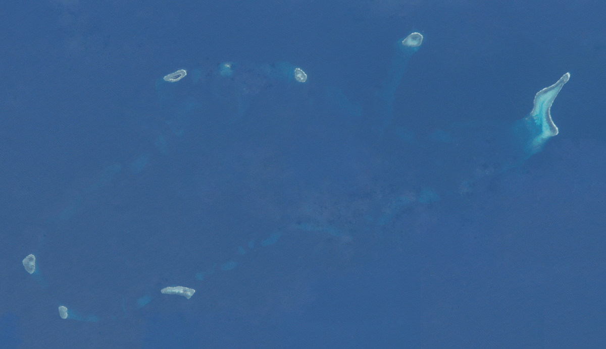 NASA's satellite photo of Namyit Island
 | |
| Location | South China Sea |
| Coordinates | 10°10′54″N 114°21′36″E / 10.18167°N 114.36000°ECoordinates: 10°10′54″N 114°21′36″E / 10.18167°N 114.36000°E |
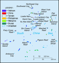
| Archipelago | Spratly Islands |
| Administered by | |
| Vietnam | |
| Claimed by | |
| People's Republic of China | |
| Philippines | |
| Republic of China (Taiwan) | |
| Part of a series on the |
| Spratly Islands |
|---|
 Spratly Islands military occupations map |
| Related articles |
| Confrontations |
|
Southwest Cay incident (1975) |
| Military occupations |
|
|
Namyit Island (Vietnamese: Đảo Nam Yết; Tagalog: Binago; simplified Chinese: 鸿庥岛; traditional Chinese: 鴻庥島; pinyin: Hongxiu Dao) is the third largest island on Tizard Bank in the Spratly Islands in South China Sea. With an area of 5.3 hectares, it is the twelfth largest Spratly island and the fifth largest among the Vietnamese-administered Spratly islands. The island is also claimed by the People's Republic of China, the Philippines and the Republic of China (Taiwan).
History in the 20th century
Although two South Vietnamese warships including HQ-04 Tuy Dong and HQ-05 Tay Ket stopped off Namyit Island in 1962,[1] South Vietnamese troops had only set up a permanent garrison on the islet since August 1973. On 6 September 1973, Republic of Vietnam's Ministry of the Interior signed Decree No. 420-BNV/HCĐP/26 merging some Spratly islands including Namyit into Phuoc Hai Commune, Dat Do District, Phuoc Tuy Province.[2] South Vietnam continued to administer the entity until 27 April 1975 when their troops were evicted by Vietnam People's Army.
Geography
Being 11 nautical miles (20 km) to the south of Itu Aba Island,[3] Namyit Island is a small oval-shaped coral island which is 600 metres (660 yd) in length and 125 metres (137 yd) in width. The coral reef on which the island lies is 0.2 metres (0.66 ft) to 0.4 metres (1.3 ft) above the sea during low tide.[3] There is a heliport at the end of island.[4]
Namyit Island Light is a white round tower with red bands standing 23m in height.
Ecology
Namyit Island has no source of fresh water, and its coral sand is not suitable for plants in general. The island is covered with small trees, bushes and grass and is inhabited by sea birds.[4] The surrounding water is home to four hundred and ninety-two species of plankton, eighty-six species of seaweed, two species of seagrass, two hundred and twenty-five species of benthic organisms, one hundred and sixty species of coral, four hundred and fourteen species of reef fish and two species of sea turtles.[5]
See also
- Truong Sa District
- Spratly Islands dispute
References
- ↑ "White Paper on the Hoang Sa (Paracel) and Truong Sa (Spratly) Islands (1975) [part 2, split by uploading site]". Ministry of Foreign Affairs (Republic of Vietnam). Retrieved March 21, 2013.
- ↑ "A number historical and juridical documents on Vietnam’s sovereignty over the Truong Sa and Hoang Sa archipelagoes- Part 3". Authority of Foreign Information Service, Ministry of Information and Communications (Vietnam). October 21, 2011. Retrieved March 21, 2013.
- ↑ 4.0 4.1 "Digital Gazetter of Spratly Islands". Retrieved 22 March 2008.
- ↑ (Vietnamese) Nguyễn Đình Quân (September 15, 2012). "Lập Khu bảo tồn biển Nam Yết". Tiền phong online. Retrieved March 21, 2013.
External links
- Namyit Island, Google Maps