Namur (province)
Namur (Dutch:  Namen , Walloon: Nameur) is a province of Wallonia, one of the three regions of Belgium. It borders (clockwise from the West) on the Walloon provinces of Hainaut, Walloon Brabant, Liège and Luxembourg in Belgium, and on France. Its capital is the city of Namur.
Subdivisions

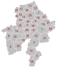
Municipal divisions of Namur (click on image for full legend).
It has an area of 3,664 square kilometres (1,415 sq mi) and is divided into three administrative districts (arrondissements in French) containing a total of 38 municipalities (communes in French).
Arrondissement of Dinant
Arrondissement of Namur
Arrondissement of Philippeville
List of Governors
- 1830 - 1834: Goswin de Stassart (Liberal)
- 1834 - 1840: Joseph Lebeau (Liberal)
- 1840 - 1847: Edouard d'Huart (Liberal)
- 1887 - 1848: Adolphe de Vrière (Liberal)
- 1848 - 1851: François Pirson (Liberal)
- 1853 - 1875: Charles de Baillet (Catholic Party)
- 1876 - 1877: D. de Mevius
- 1877 - 1881: Albert de Beauffort (Catholic Party)
- 1881 - 1882: Léon Pety de Thozée (Liberal)
- 1882 - 1884: Auguste Vergote
- 1884 - 1914: Charles de Montpellier de Vedrin
- 1919 - 1937: Pierre de Gaiffier d'Hestroy
- 1937 - 1944: François Bovesse (Liberal)
- 1945 - 1968: Robert Gruslin
- 1968 - 1977: René Close (PS)
- 1977 - 1980: Pierre Falize (PS)
- 1980 - 1987: Emile Lacroix
- 1987 - 1994: Emile Wauthy (PSC)
- 1994 - 2007: Amand Dalem (PSC)
- 2007–present: Denis Mathen (MR)
See also
References
External links

![]() Namen , Walloon: Nameur) is a province of Wallonia, one of the three regions of Belgium. It borders (clockwise from the West) on the Walloon provinces of Hainaut, Walloon Brabant, Liège and Luxembourg in Belgium, and on France. Its capital is the city of Namur.
Namen , Walloon: Nameur) is a province of Wallonia, one of the three regions of Belgium. It borders (clockwise from the West) on the Walloon provinces of Hainaut, Walloon Brabant, Liège and Luxembourg in Belgium, and on France. Its capital is the city of Namur.


.svg.png)
