Namangan Region
Coordinates: 41°0′N 71°10′E / 41.000°N 71.167°E
| Namangan Province | |
| Namangan viloyati Наманган вилояти | |
| Province | |
| Country | Uzbekistan |
|---|---|
| Capital | Namangan |
| Area | 7,900 km2 (3,050 sq mi) |
| Population | 1,862,000 (2005) |
| Density | 236 / km2 (611 / sq mi) |
| ISO 3166-2 | UZ-NG |
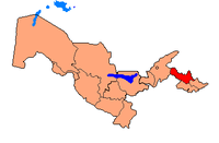 | |
Namangan Province (Uzbek: Namangan viloyati, Russian: Наманганская область) is a viloyat (province) of Uzbekistan, located in the southern part of the Fergana Valley in far eastern part of the country. It is on the right bank of Syr Darya River and borders with Kyrgyzstan, Fergana Province and Andijan Province. It covers an area of 7,900 km2. The population is estimated to be around 1,970,000, with over 62% of the population living in rural areas.
Districts
Namangan Province is divided into 11 administrative districts.
| Key | District name | District capital |
|---|---|---|
| 1 | Chartak District | Chartak |
| 2 | Chust District | Chust |
| 3 | Kasansay District | Kasansay |
| 4 | Mingbulak District | Jumashuy |
| 5 | Namangan District | Tashbulak |
| 6 | Naryn District | Khakkulabad |
| 7 | Pap District | Pap |
| 8 | Turakurgan District | Turakurgan |
| 9 | Uchkurgan District | Uchkurgan |
| 10 | Uychi District | Uychi |
| 11 | Yangikurgan District | Yangikurgan |
The climate is a typically continental climate with extreme differences between winter and summer temperatures.
Natural resources include deposits of petroleum, natural gas, gold, lead, copper, quartz and antimony. Main agriculture includes cotton, horticulture and sericulture, animal husbandy, including breeding of Angora goats for their valuable down hair.
Industry is primarily based on textiles, with two large silk production complexes, a non-woven fabric manufacturing plant, cotton yarn processing, and numerous smaller textile, leather and footwear plants. The area is also a center for the production of traditional Uzbek handicrafts, especially knives.
References
- Uzbekistan CIA - The World Factbook
External links
- Official site of Namangan Province (Russian).
 |
Jalal-Abad Province, |
| ||
| Tashkent Province | |
|||
| ||||
| | ||||
| Sughd Province, |
Fergana Province | Andijon Province |
| ||||||||