Nakhon Ratchasima
| Nakhon Ratchasima, Thailand นครราชสีมา Korat City | |
|---|---|
| City Municipality | |
| Nakhon Ratchasima City | |
|
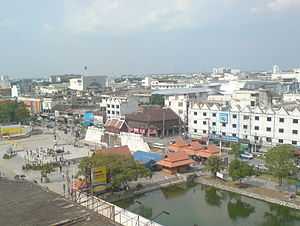
Downtown Nakhon Ratchasima | |
| Nickname(s): Khorat / Korat | |
 Nakhon Ratchasima, Thailand | |
| Coordinates: 14°58′50″N 102°6′00″E / 14.98056°N 102.10000°E | |
| Country |
|
| District | Mueang Nakhon Ratchasima |
| Province | Nakhon Ratchasima |
| - Settled | AD.1656 (Ayutthaya Period) |
| - as Sanitary districts | 3 Jan 1908 |
| - as Municipality | 7 Dec 1935 |
| Government | |
| • Type | City Municipality |
| • Mayor | Surawuth Cherdchai |
| • Municipal Clerk | Arlom Tangtaku |
| Area | |
| • City Municipality | 37.5 km2 (14.5 sq mi) |
| • Land | 37.4 km2 (14.45 sq mi) |
| • Metro | 767.98 km2 (296.52 sq mi) |
| Population (2011) | |
| • City Municipality | 166,217 |
| • Density | 4,432.45/km2 (11,480.0/sq mi) |
| • Metro | 444,023 |
| • Metro density | 578.17/km2 (1,497.5/sq mi) |
| • Demonym | Korat |
| Time zone | ICT (UTC+7) |
| Area code(s) | 044 |
Nakhon Ratchasima (Thai: นครราชสีมา, pronounced [náʔkʰɔːn râːt.tɕʰa.sǐː.maː]) or (Khmer: នគររាជសីមា) is one of the four major cities of Isan, Thailand, known as the "Big 4 of Isan". The city is commonly known as Korat (RTGS Khorat, โคราช), a short form of its previous name. It is the capital of the Nakhon Ratchasima Province and Nakhon Ratchasima District. Nakhon Ratchasima is the heart of the Nakhon Ratchasima metropolitan area.
Khorat is at the western edge of the Khorat Plateau. Historically, it has marked the boundary between Lao and Siamese territory. Today it is considered a gateway to the northeast (Isan). Its geographical location is 14°58.5′N 102°6′E / 14.9750°N 102.100°ECoordinates: 14°58.5′N 102°6′E / 14.9750°N 102.100°E. As of 2010, the municipal area had a population of 142,645.[1]
Etymology
Archeological evidence suggests that in Sung Noen District, 32 km west of present-day Nakhon Ratchasima (Khorat), there were two ancient towns called Sema ("Bai sema" (ใบเสมา) are notable artifacts of the Khorat plateau)[2] and Khorakapura. (Pali púra becomes Sanskrit puri, hence Thai บุรี, บูรี (buri), all connoting the same as Thai mueang: "city with defensive wall".) Noting that, the real names of the two ancient towns are not known and the names "Sema" and "Khorakapura" were only assigned in the 20th century. The latter name was shortened to Nakhon Raj. (Nakhon (นคร) derives from Sanskrit nagara (नगर), "city"; Raj (ราช), from Sanskrit Raj, "sovereign.") The present city name is a portmanteau of Nakhon Raj and Sema.
The city is commonly known as "Khorat" or "Korat" (Thai: โคราช), which is a short version of the ancient Khmer name "ankor raj".
History

Prior to the 14th century, the area of Nakhon Ratchasima was under Khmer empire suzerainty and known in Khmer as Nokor Reach Seyma / Nokor Reach Borei, and Koreach, while Phimai to the north was probably more important.
King Narai of Ayutthaya in the 17th century, ordered a new city built on the site to serve as a stronghold on Ayutthaya's northeastern frontier. Nakhon Ratchasima was thereafter mentioned in Siamese chronicles and legal documents as a "second-class" city of the Ayutthaya Kingdom. A royal governor ruled the city in a hereditary position.
After the final phase of the Ayutthaya kingdom ended with its complete destruction by the Burmese in 1767, a son of King Boromakot attempted to set himself up ruler in Phimai, holding sway over Khorat and other eastern provinces. King Taksin of the Thonburi Kingdom (1768–1782) sent two of his generals, brothers Thong Duang and Boonma, to defeat the prince, who was executed in 1768. Thong Duang later became King Rama I of the kingdom, and Khorat became his strategic stronghold on the northeastern frontier to supervise the Lao and Khmer tributary states.

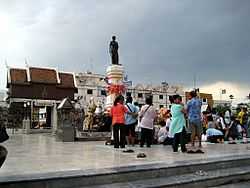
In 1826, Vientiane King Chao Anouvong, perceiving Siam as weakened, attacked Khorat in the Laotian Rebellion against King Rama III that was to rage on for two years.[3] Lady Mo, the wife of the deputy governor at the time, is credited with having freed the city from Anouvong's army, and has been honored with a statue in the center of downtown Khorat. A full account of the war and its impact on Laos and Siam, is well-detailed in the book, Lady Mo and Heroism at Tung Samrit, written by Frank G Anderson. The city's old wall, east of the monument was designed and built by a French engineer who is believed to be the one who also built Naraimaharaj Palace in Lopburi. The French-based design is reflected in the moat system that surrounds the innermost portion of the city.
Nakhon Ratchasima continued to be an important political and economic center in the northeastern region under the Monthon administrative reforms of the late 19th century. In November 1900, the Royal State Railways of Siam began operation of the Nakhon Ratchasima Line from Bangkok with Khorat Station as its terminus. The Ubon Ratchathani Line to the town of Warin opened 1 November 1922. The Thanon Chira Junction to Khon Kaen opened on 1 April 1933. Khorat station was changed to Nakhon Ratchasima Railway Station in 1934.
In October 1933, after the Siamese revolution of 1932 ended the absolute monarchy, the city became the headquarters of the Boworadet Rebellion, an abortive uprising against the new government in Bangkok.
In April 1981 during another attempted coup, the government, together with the royal family, took refuge in Khorat.
From 1962-1976, during the Vietnam War, Korat Royal Thai Air Force Base hosted components of the Royal Thai Air Force, the United States Air Force, and a complement of the Royal New Zealand Air Force (RNZAF). After the US withdrawal in 1976, the Thai Air Force assumed full control. During the 1980s and early 1990s, the airfield was jointly operated as a civil airport for Nakhon Ratchasima. This ended with the opening of Nakhon Ratchasima Airport in the early 1990s.
In August 1993, Thailand's worst hotel disaster happened in the city, the collapse of the Royal Plaza Hotel, killing more than 130 people.

Transportation

Nakhon Ratchasima is on the northeastern railway line, connecting Bangkok with Ubon Ratchathani and Nong Khai. Also passing the city is Mittraphap Road (Thailand Route 2).
26 km east of the city is the Nakhon Ratchasima Airport. As at 30 November 2006, however, the airport does not handle passenger traffic, and shipping has not been seen as a major commercial possibility. Several attempts to run passenger services have ended in failure, despite charges as low as 99 baht to fly to Bangkok, and authorities are still discussing ways to make the 400 million baht investment a paying venture. Happy Air (HPY) planned to fly from Nakhon Ratchasima to Chiang Mai and Bangkok with the 33-seat Swedish built Saab 340 with services intended to begin in August 2010. However, there are still no scheduled air services operating from the airport.[4]
Major points of interest


- Thao Suranaree Monument - Currently (2014) under renovation.
- Wat Sala Loi
- Khorat Zoo - The zoo is about 13 km (8.1 mi) south of the city on Hwy 304.
- Korat Royal Thai Air Force Base was used by the United States Air Force during the Vietnam War. It is some 8 km south of the city.
Khorat has becoming increasingly attractive to foreigners over the last five years, with growing numbers mostly from North America and Europe moving to the province. Still rustic, with cheap housing and land prices, the province is only three hours drive from Bangkok, (by bus or train) and as its '"gateway to the northeast" moniker suggests, Khorat connects the other 18 northeast Thailand provinces with the central region by rail and highway.
Korat cat

(Thai: โคราช, มาเลศ, สีสวาด, rtgs: Khorat, Malet, Sisawat)
The Korat is a natural breed, and one of the oldest stable cat breeds. Originating in Thailand, it is named after the Nakhon Ratchasima province (widely called "Korat" by Thai people). In Thailand the breed is known as Si-Sawat, meaning "colour of the sawat seed". They are known colloquially as the "good luck cat" and are given in pairs to newlyweds or to people who are highly esteemed, for good luck. Until recently, Korats were not sold, but only given as gifts.
Korats first appeared in Britain under the name "Blue Siamese" in 1889 and 1896, but as these solid blue cats did not conform to the cat show judges' perception of a Siamese cat they disappeared by 1901. One early import, "Dwina", owned by Russian Blue breeder Mrs Constance Carew-Cox and mentioned in Frances Simpson's The Book of the Cat (1903), reputedly produced a large number of "Siamese" kittens; the other, Mrs B. Spearman's Blue Siamese male, "Nam Noi", was disqualified as a Siamese, but accepted in the Russian or Any Other Blue class in which he placed first (WR Hawkins, "Around the Pens" July 1896). Spearman tried unsuccessfully to import more of these "Blue Siamese".
Korats first appeared in America in the 1950s. In 1959, Cedar Glen cattery was the first to import a pair of Korats to the US for breeding: a male named Nara and a female named Darra. The Korat was introduced to the UK by Betty Munford of the High Street, Hungerford.
Climate
There are generally three seasons in the region: Hot (February - May), Rainy (May - October), Cold (October - February). In the cold season, minimum temperatures in Korat proper will drop to about 18 °C (64 °F), and in rural areas, down to about 12 °C (54 °F).
| Climate data for Nakhon Ratchasima(1981–2010) | |||||||||||||
|---|---|---|---|---|---|---|---|---|---|---|---|---|---|
| Month | Jan | Feb | Mar | Apr | May | Jun | Jul | Aug | Sep | Oct | Nov | Dec | Year |
| Average high °C (°F) | 30.7 (87.3) |
33.6 (92.5) |
35.6 (96.1) |
36.5 (97.7) |
35.0 (95) |
34.4 (93.9) |
33.8 (92.8) |
33.2 (91.8) |
32.2 (90) |
31.0 (87.8) |
30.1 (86.2) |
29.3 (84.7) |
32.95 (91.32) |
| Average low °C (°F) | 18.5 (65.3) |
21.0 (69.8) |
23.2 (73.8) |
24.9 (76.8) |
25.0 (77) |
25.1 (77.2) |
24.7 (76.5) |
24.5 (76.1) |
24.0 (75.2) |
23.2 (73.8) |
21.1 (70) |
18.3 (64.9) |
22.79 (73.03) |
| Average rainfall mm (inches) | 8.2 (0.323) |
16.1 (0.634) |
37.1 (1.461) |
72.2 (2.843) |
154.1 (6.067) |
104.5 (4.114) |
120.9 (4.76) |
157.2 (6.189) |
228.3 (8.988) |
146.3 (5.76) |
23.9 (0.941) |
2.7 (0.106) |
1,071.5 (42.186) |
| Avg. rainy days (≥ 1 mm) | 1 | 2 | 5 | 8 | 15 | 13 | 15 | 16 | 19 | 12 | 4 | 1 | 111 |
| Average relative humidity (%) | 64 | 62 | 61 | 65 | 73 | 72 | 73 | 75 | 80 | 78 | 71 | 66 | 70 |
| Mean monthly sunshine hours | 284.2 | 245.1 | 253.8 | 248.1 | 237.5 | 208.6 | 194.6 | 187.3 | 169.0 | 233.4 | 257.3 | 282.0 | 2,800.9 |
| Source: Thai Meteorological Department (Normal 1981-2010), (Avg. rainy days 1961-1990) | |||||||||||||
Education
Universities
There are 4 universities in the area.
- Suranaree University of Technology
- Nakhon Ratchasima Rajabhat University
- Rajamangala University of Technology Isan
- Vongchavalitkul University
Schools
- Saint Mary's College Nakhon Ratchasima
- Suratham Pitak School
- Rajsima Wittayalai School
- Suranaree Witthaya School
- Boonwattana School
- St.Mary Business Administration College
- Assumption School Nakhon Ratchasima
- Marie vitthaya School Nakhon Ratchasima
International schools
- Anglo Singapore International School (Korat Campus)
Facilities
Hospitals
.jpg)
- Fort Suranaree Hospital
- Saint Mary's Hospital
- Korat Memorial Hospital
- Bangkok-Ratchasima Hospital
- Po-Pat Hospital
- Maharat Nakhon Ratchasima Hospital
- The Golden Gate Hospital
Shopping centres and department stores
- The Mall Nakhon Ratchasima including Home Pro and EGV Cinemas, on Mittraphap Road
- Big C Supercenter, on Mittraphap-Nong Khai Road
- Klang Plaza Atsadang, on Atsadang Road.
- Klang Plaza Chomsurang, on Chomsurangyat Road
- Klang Villa Suranarai Road
- IT City, on Mittraphap Road.
- Makro, on Mittraphap-Nong Khai Road.
- Tesco Lotus Nakhon Ratchasima 1 Hypermarket, on Road No.2 (Mittraphap)
- Tesco Lotus Nakhon Ratchasima 2 Departmentstore, on Road No.224 (Ratchasima-Chok Chai)
- Home Pro Nakhon Ratchasima, on Road No.204 (By Pass Mittraphap)
- Central Plaza Nakhon Ratchasima (opening in early 2016)
- Terminal 21 Nakhon Ratchasima(opening in early 2015)
Sports

80th Birthday Stadium
The 80th Birthday Stadium is a sports facility in Nakhon Ratchasima, Thailand. It is the main stadium in His Majesty the King's 80th Birthday Anniversary, 5th December 2007 Sports Complex. It is home to Nakhon Ratchasima FC, a Thailand Premier League team and was used for the 2007 SEA Games.
The stadium is in the former SEA Games sports complex on Highway 304 (Pak Thong Chai Road) to the southwest of the city of Nakhon Ratchasima. The stadium is all-seater with capacity for 20,000 spectators. The tribunes form a continuous ring, almost a perfect circle, around the pitch and running track. The stands are uncovered on three sides but a huge cantilevered roof provides cover for about 7,000 seats on one side where the ring rises to approximately double the height of the tribune it faces. Most of the seats in the stadium are bright orange (the same colour as Nakhon Ratchasima FC's home kit) and are the fixed-bucket style. In the main stand some of the seats at the top of the tribune are red and those in the VIP section are not fixed bucket, but the tip-up type favoured in the UK. In the lower sections of the main stand the initials SAT (Sports Authority of Thailand) are picked out in blue. The equivalent letters in Thai script are also picked out in blue. There are commentary boxes and private suites at the top of the main stand. There is also a large royal box in the middle of the main stand. At the northern end of the stadium is a large scoreboard. At the opposite end are the three flagpoles used for the SEA Games and the place where the Olympic flame burned.
Football clubs
- Nakhon Ratchasima FC
- Pakchong United F.C.
Local media
Newspapers
- The Korat Daily. Thai language.
- The Korat Post. English-language monthly.
See also
- Nakhon Ratchasima Province
- List of Cities, Towns and Townships in Nakhon Ratchasima Province
- Korat (cat)
References
- ↑ Department of Provincial Administration, Ministry of Interior, Royal Thai Government. 16 August 2010
- ↑ Phetsanghan, Phairot; Chantachon, Songkoon; Yodmalee, Boonsom (2009). "Sema Hin Isan, the Origin of the Temple Boundary Stones in Northeast Thailand". The Social Sciences (Medwell Journals) 4 (2): 186–190. Retrieved 2015-01-04.
- ↑ Chandler, David P.; Roff, William R.; Smail, John R.W.; Steinberg, David Joel; Taylor, Robert H.; Woodside, Alexander & Wyatt, David K. (1987) [1971]. "13 Siam, 1767–1868". In David, Steinberg. In search of Southeast Asia (Revised ed.). Honolulu: University of Hawaii Press. pp. 113–117. ISBN 0-8248-1110-0. OCLC 500095794. Lay summary (Jan 8, 2008).
- ↑ "Nakhon Ratchasima Airport". Flightstats.com. Retrieved 29 April 2012.
External links
| Wikimedia Commons has media related to Nakhon Ratchasima. |
 Nakhon Ratchasima travel guide from Wikivoyage
| |||||||||||||||||||||||||||||||||||||||||||||||
| ||||||||||